Showing 1923 items
matching https://www.lynxlace.com/kindsoflace.html
-
 St Kilda Historical Society
Photograph - Photo map, Department of Crown Lands and Survey, 22/01/1970
One of a series of photo-maps produced for the Department of Crown Lands and Survey (1857-1983). For correlation with a current map, and access to other historical photo maps of Victoria, see the Historic Photo-Maps Index published by the Department of Environment, Land, Water and Planning at https://services.land.vic.gov.au/DELWPmaps/historical-photomaps/Black and white aerial photographVic 2358 Department of Crown Lands and Survey Victoria,.© Melbourne 1970 Project Run 42E 22.1.70 5,100 ASL 75st kilda, st kilda beach, st kilda marina, point ormond, st kilda pier, 1970 -
 St Kilda Historical Society
Photograph - Photo map, 14/12/1963
One of a series of photo-maps produced for the Department of Crown Lands and Survey (1857-1983). For correlation with a current map, and access to other historical photo maps of Victoria, see the Historic Photo-Maps Index published by the Department of Environment, Land, Water and Planning at https://services.land.vic.gov.au/DELWPmaps/historical-photomaps/Black and white aerial photographVic 1807 Melbourne 1963 Project Run 16 14.12.1963 Lens 205 152.70 M/M 5.150 177st kilda, st kilda pier, catani gardens, middle park, albert park, st kilda west, st kilda beach, 1963 -
 St Kilda Historical Society
Photograph - Photo map, Department of Crown Lands and Survey, 22/01/1970
One of a series of photo-maps produced for the Department of Crown Lands and Survey (1857-1983). For correlation with a current map, and access to other historical photo maps of Victoria, see the Historic Photo-Maps Index published by the Department of Environment, Land, Water and Planning at https://services.land.vic.gov.au/DELWPmaps/historical-photomaps/Black and white aerial photographVic 2358 Department of Crown Lands and Survey Victoria,.© Melbourne 1970 Project Run 41E 22.1.70 5,100 ASL 64st kilda, st kilda cemetery, balaclava, st kilda east, windsor, caulfield north, alma park, 1970 -
 St Kilda Historical Society
Photograph - Photo map, Department of Crown Lands and Survey, 08/01/1970
One of a series of photo-maps produced for the Department of Crown Lands and Survey (1857-1983). For correlation with a current map, and access to other historical photo maps of Victoria, see the Historic Photo-Maps Index published by the Department of Environment, Land, Water and Planning at https://services.land.vic.gov.au/DELWPmaps/historical-photomaps/Black and white arial photographVic 2345 Department of Crown Lands and Survey Victoria,.© Melbourne 1970 Project Run 40 8.1.70 5,100 ASL 77albert park, fawkner park, south yarra, middle park, prahran, windsor, st kilda, st kilda west, 1970 -
 St Kilda Historical Society
Photograph - Photo map, 22/01/1970
One of a series of photo-maps produced for the Department of Crown Lands and Survey (1857-1983). For correlation with a current map, and access to other historical photo maps of Victoria, see the Historic Photo-Maps Index published by the Department of Environment, Land, Water and Planning at https://services.land.vic.gov.au/DELWPmaps/historical-photomaps/Black and white aerial photographVic 2358 Department of Crown Lands and Survey Victoria,.© Melbourne 1970 Project Run 43E 22.1.70 5,100 ASL 206elwood, elsternwick, elsternwick park, 1970 -
 Bendigo Historical Society Inc.
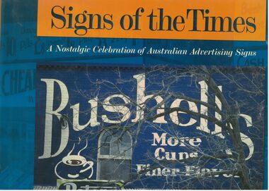
Book - Signs of the Times
Well-known as an artist, author, historian, illustrator and publisher, Geoff Hocking grew up in the goldfields city of Bendigo and lives today in Castlemaine. His work reflects a passion for the heritage of the goldfields region. https://artsopen.com.au/wp-content/uploads/2021/11/geoff-hocking-CV-2019.pdf Full title. "Signs of the Times. A nostalgic Celebration of Australian Advertising Signs. Written by Geoff Hocking. Published by Five Mile Press in 2007. Hard cover book with dust jacket. Blue and gold colouring. Front cover has a picture of a Bushells sign on a brick wall with a peters Ice cream sign in the corner. Back cover has eight smaller advertising signs. 228 pp. containing advertising signs from across Australia with historical notes and descriptions.signs, geoff hocking, photographs, advertising -
 Eltham District Historical Society Inc
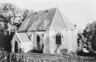
Photograph, Catholic Church, Main Street, Diamond Creek, c.1963
Photo sourced from N. Stone reproduced on p178 of The Diamond Valley Story by Dianne H. Edwards, Shire of Diamond Valley 1979. "The first Catholic Church, Main Street, Diamond Creek. Opened in 1874, it has been replaced by the new Sacred Heart Church next to the railway station. Additions built during the 1970s have transformed it into an abbey-like restaurant. This photo shows the building before the alterations." Similar image by John T. Collins held by State Library of Victoria dated 1963 http://search.slv.vic.gov.au/permalink/f/1o9hq1f/SLV_VOYAGER1672213 Former Catholic church with significant development became the Abbey Reception Centre and now Tobin Brothers 49-55 Main Street See images https://tobinbrothers.com.au/diamond-creek/Black and white copy of photo printed on glossy photographic paper 30.5 x 40.5 cm (12 x 16 inch); image size approx. 18.5 x 28 cmabbey reception centre, catholic church, diamond creek, diamond valley story, tobin brothers, main street -
 Eltham District Historical Society Inc
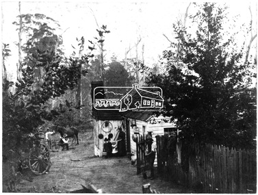
Photograph, H.J. Trowbridge, First kitchen at the first Post Office, Kinglake, c.1905, 1905
Reproduced 'Pioneers & Painters' p43 Source: Mrs. McMinn, Kinglake The photo is embossed in the lower left hand "H.J. Trowbridge," a photographer operating from at least 1895 and a photo stock dealer, developer and printer operating from Camera House in Collins St, Melbourne importing the finest English photographic equipment, paper, etc from 1905 through 1910 when he retired (Photo-focus. (1910, September 1). Punch (Melbourne, Vic. : 1900 - 1918; 1925), p. 3. Retrieved from http://nla.gov.au/nla.news-article175606285). He produced a 200 page catalogue in 1906 (H. J. TROWBRIDGE'S CATALOGUE. (1906, November 22). Punch (Melbourne, Vic. : 1900 - 1918; 1925), p. 3. Retrieved from http://nla.gov.au/nla.news-article175379934)This photo forms part of a collection of photographs gathered by the Shire of Eltham for their centenary project book,"Pioneers and Painters: 100 years of the Shire of Eltham" by Alan Marshall (1971). The collection of over 500 images is held in partnership between Eltham District Historical Society and Yarra Plenty Regional Library (Eltham Library) and is now formally known as 'The Shire of Eltham Pioneers Photograph Collection.' It is significant in being the first community sourced collection representing the places and people of the Shire's first one hundred years.Digital image of 4 x 5 inch B&W Negative Also 19 x 25 cm printPhotographers name H.J. Trowbridge Lwr LHsepp, shire of eltham pioneers photograph collection, kinglake, post office -
 Federation University Historical Collection
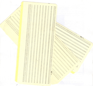
Document - Computer card, IBM, 80 Column IBM Computer punch card
This IBM card format, designed in 1928, had rectangular holes, 80 columns with 12 punch locations each, one character to each column. Card size was exactly 7-3/8 inch by 3-1/4 inch (187.325 by 82.55 mm). The cards were made of smooth stock, 0.007 inch (0.178 mm) thick. There are about 143 cards to the inch. In 1964, IBM changed from square to round corners. They came typically in boxes of 2000 cards.[20] (Reference and more information at http://en.wikipedia.org/wiki/Punched_card ) Early digital computers used punched cards, often prepared using keypunch machines, as the primary medium for input of both computer programs and data. (http://en.wikipedia.org/wiki/Punched_card) Yellow card with printed numbers. Used for feeding information into a computer.computer, computer card, ibm, data, punch card, punched card, binary -
 St Kilda Historical Society
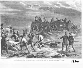
Photograph - Photograph of artwork, Illustrated Sydney News, Erection of New Butts by the Members of the St Kilda Battery R.V.V.A, 28/02/1874
Erection of new butts by the members of the St Kilda Volunteer Army Corps in 1874, after the government took possession of the land that the Volunteer Army Corps had been using. The butts were banks constructed of sand and earth, kept together with saplings, to create areas for shooting practice. They were constructed on the beach at Hobson's Bay, half a mile from the St Kilda jetty. An article about this appeared in the Illustrated Australian News for Home Readers on 25 February 1874, available on the National Library of Australia Trove site https://trove.nla.gov.au/newspaper/article/63105925. The lithograph appeared in the Illustrated Sydney News and New South Wales Agriculturalist and Grazier on 28 February 1874, available on the National Library of Australia Trove site https://trove.nla.gov.au/newspaper/article/63105925Photograph of black and white lithograph Erection of New Butts by the Members of the St Kilda Battery R.V.V.A. 1874st kilda volunteer army corps -
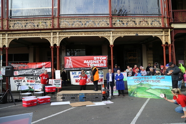
 Victorian Farmers Federation
Photograph - Digital Photograph, Stop Ausnet Rally Ballarat - Katherine Myers, Scott Young, Charles Everist, 15 July 2022
VFF is seeking an appropriate framework to ensure farmers do not bear the cost of infrastructure on their farms. Overhead powerlines are proposed through the rich volcanic soils around Ballarat. This land supports 1200 jobs in processing in Ballarat. The towers would impact on the ability to irrigate crops, to use tractors around them, on biosecurity and on ability to use emergency equipment near them. VFF wants assurances that the managing entry to farm policy position will be adhered to and that a statewide strategic plan for renewable energy is prepared. https://www.vff.org.au/wp-content/uploads/2021/09/PS210901LG-Managing-Entry-to-Farms-adopted.pdf https://www.vff.org.au/wp-content/uploads/2021/09/VFF-Renewable-Energy-and-Energy-Efficiency-Policy-Statement-Meeting-172-June-2021.pdfadvocacy, renewable energy, farmers, protest, rally, managing entry to farm, victorian farmers federation, ballarat -
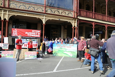
 Victorian Farmers Federation
Photograph - Digital Photograph, Stop Ausnet Rally Ballarat - post event scenes, 15 July 2022
VFF is seeking an appropriate framework to ensure farmers do not bear the cost of infrastructure on their farms. Overhead powerlines are proposed through the rich volcanic soils around Ballarat. This land supports 1200 jobs in processing in Ballarat. The towers would impact on the ability to irrigate crops, to use tractors around them, on biosecurity and on ability to use emergency equipment near them. VFF wants assurances that the managing entry to farm policy position will be adhered to and that a statewide strategic plan for renewable energy is prepared. https://www.vff.org.au/wp-content/uploads/2021/09/PS210901LG-Managing-Entry-to-Farms-adopted.pdf https://www.vff.org.au/wp-content/uploads/2021/09/VFF-Renewable-Energy-and-Energy-Efficiency-Policy-Statement-Meeting-172-June-2021.pdfadvocacy, renewable energy, farmers, protest, rally, managing entry to farm, victorian farmers federation, ballarat -
 Victorian Farmers Federation
Photograph - Digital Photograph, Stop Ausnet Rally Ballarat, 15 July 2022
VFF is seeking an appropriate framework to ensure farmers do not bear the cost of infrastructure on their farms. Overhead powerlines are proposed through the rich volcanic soils around Ballarat. This land supports 1200 jobs in processing in Ballarat. The towers would impact on the ability to irrigate crops, to use tractors around them, on biosecurity and on ability to use emergency equipment near them. VFF wants assurances that the managing entry to farm policy position will be adhered to and that a statewide strategic plan for renewable energy is prepared. https://www.vff.org.au/wp-content/uploads/2021/09/PS210901LG-Managing-Entry-to-Farms-adopted.pdf https://www.vff.org.au/wp-content/uploads/2021/09/VFF-Renewable-Energy-and-Energy-Efficiency-Policy-Statement-Meeting-172-June-2021.pdfadvocacy, renewable energy, farmers, protest, rally, managing entry to farm, victorian farmers federation, ballarat -
 Victorian Farmers Federation
Photograph - jpg image, Lisa Gervasoni, Stop Ausnet Rally Ballarat, 15 July 2022
VFF is seeking an appropriate framework to ensure farmers do not bear the cost of infrastructure on their farms. Overhead powerlines are proposed through the rich volcanic soils around Ballarat. This land supports 1200 jobs in processing in Ballarat. The towers would impact on the ability to irrigate crops, to use tractors around them, on biosecurity and on ability to use emergency equipment near them. VFF wants assurances that the managing entry to farm policy position will be adhered to and that a statewide strategic plan for renewable energy is prepared. https://www.vff.org.au/wp-content/uploads/2021/09/PS210901LG-Managing-Entry-to-Farms-adopted.pdf https://www.vff.org.au/wp-content/uploads/2021/09/VFF-Renewable-Energy-and-Energy-Efficiency-Policy-Statement-Meeting-172-June-2021.pdfphotos of Lydiard St Stop Ausnet Rallyadvocacy, renewable energy, farmers, protest, rally, managing entry to farm, victorian farmers federation, ballarat -
 Victorian Farmers Federation
Film - mp4 clip, Stop Ausnet Rally Ballarat Katherine Myers VFF speech
VFF is seeking an appropriate framework to ensure farmers do not bear the cost of infrastructure on their farms. Overhead powerlines are proposed through the rich volcanic soils around Ballarat. This land supports 1200 jobs in processing in Ballarat. The towers would impact on the ability to irrigate crops, to use tractors around them, on biosecurity and on ability to use emergency equipment near them. VFF wants assurances that the managing entry to farm policy position will be adhered to and that a statewide strategic plan for renewable energy is prepared. https://www.vff.org.au/wp-content/uploads/2021/09/PS210901LG-Managing-Entry-to-Farms-adopted.pdf https://www.vff.org.au/wp-content/uploads/2021/09/VFF-Renewable-Energy-and-Energy-Efficiency-Policy-Statement-Meeting-172-June-2021.pdfphotos of Lydiard St Stop Ausnet Rallyadvocacy, renewable energy, farmers, protest, rally, managing entry to farm, victorian farmers federation, ballarat -
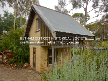 Eltham District Historical Society Inc
Photograph - Digital Photograph, Jim Connor, Mudbrick cottage, 62 Bougham Street, Eltham, 23 December 2012
The mud-brick cottage and the adjacent shed at 62 Brougham Street, Eltham were built in 1969 by Peter Garner, who was in his mid-teenage years at the time. PETER GARNER MUD BRICK STUDIO AND ADJACENT SHED 62 BROUGHAM STREET ELTHAM, NILLUMBIK SHIRE https://vhd.heritagecouncil.vic.gov.au/places/55317jim connor collection, mudbrick construction, brougham steet, eltham, peter garner -
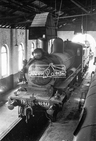 Eltham District Historical Society Inc
Photograph, Steam locomotive D3-640 in the Locomotive Shed, Echuca Railway Station, 1962, 1962
Image dated as 1962 based on same image in Port of Echuca collection (print 20 x 25.5cm) On reverse in pencil: "351, D3 Intro 1902 DD, Converted 1929 D3" In blue pen:" Echuca Locomotive shed 1962 Photograph: George L. Coop" https://victoriancollections.net.au/items/59d5663721ea6e1278d00bdcDigital TIFF file Scan of 35mm Ilford FP3 black and white negative transparencyd3-640, echuca railway station, george coop collection, railway workshop -
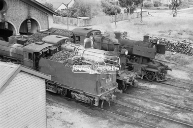 Eltham District Historical Society Inc
Photograph, Steam locomotives K-155, D3-677 and J-511 ouside the locomotive shed, Echuca Railway Station, November 1962, 1962
Note: D3-677 has a large amount of calcification accumulated on its boiler Image dated as November 1962 based on same image in Port of Echuca collection (print 19.5 x 24.5cm) On reverse in blue pen:" Photo by: George L. Coop Nov 1962" https://victoriancollections.net.au/items/59dead0921ea6e12dc45fc25Digital TIFF file Scan of 35mm Ilford FP3 black and white negative transparencyd3-677, d3-class steam locomotive, echuca railway station, george coop collection, j-511, j-class steam locomotive (vulcan foundry), k-155, k-class steam locomotive (vr newport workshops), railway workshop -
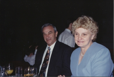 Ballarat Heritage Services
Photograph - Digital photograph, Keith and Kathleen Hamilton
Keith and Kath Hamilton at Blythwood Grange chapel, the former St Joseph's Home. Keith Hamilton, born 9 May 1936 in Ballarat was the MP for Morwell for the Labour Party. He was Minister for Aboriginal Affairs, and Minister for Agriculture for some years. See more information https://en.wikipedia.org/wiki/Keith_Hamilton_(politician)Digital photograph pf Keith and Kathleen Hamilton. keith hamilton, kath hamilton, ballarat, morwell, member of parliament, minister for agriculture, minister for aboriginal affairs -
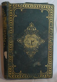 Buninyong Visitor Information Centre
Book, Groombridge and Sons, The Vicar of Wakefield, by Dr. Goldsmith
The Vicar of Wakefield, subtitled A Tale, Supposed to be written by Himself, is a novel by Anglo-Irish writer Oliver Goldsmith (1728–1774). It was written from 1761 to 1762 and published in 1766. It was one of the most popular and widely read 18th-century novels among Victorians. Source: Wikipedia: https://en.wikipedia.org/wiki/The_Vicar_of_WakefieldHard cover, cloth bound book with gold embossed design on the cover. The book is entitled The Vicar of Wakefield, by Dr. Goldsmith. Undated.'Buninyong Public Library' stamp used in several places in the book. novels, oliver goldsmith, literature -
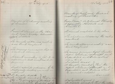 Bendigo Historical Society Inc.
Administrative record - McDonald's Reef Gold Mining Company Minute Book, 1913 to 1915
McDonalds Reef Gold Mining Company was located at Fryerstown. The registered office of the Company was at View Street, Bendigo. It was registered in the Government Gazette 28, Date: Friday, April 14th 1899 .https://gazette.slv.vic.gov.au/view.cgi?year=1899&class=general&page_num=1256&state=V&classNum=G28&searchCode=8966129Minute book of the McDonald's Reef Gold Mining Company. Black cover with maroon binding, one hundred and eighty-nine pages, hand written entries dating from Monday June 30th, 1913 to 23rd July 1915. The first meeting of shareholders was held at Scotts Hotel, Collins Street, Melbourne. bendigo, gold mining, share transfers, margaret roberts collection, mcdonald reef gold mining company, fryerstown, castlemaine -
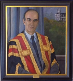 Geoffrey Kaye Museum of Anaesthetic History
Painting - Portrait, Audrey Wilson, Presidential Portrait of Dr Michael J H Hodgson, 1995
Dr Michael Hodgson was apppointed ANZCA President in 1992 until 1993. The painting, undertaken in 1995, was later unveiled in 1996 with Dr. Hodgson present. Further information about Dr. Hodgson can be found on The Lives of the Fellows, http://anzca.online-exhibition.net/fellows/fellows-1992/michael-john-hind-hodgson/ Oil painting on canvas of Dr Michael J H Hodgson seated in front of blue-grey drapery and a window showing Ulimaroa in the distance. The subject is wearing the Presidential gown but not the Presidential badge. Framed in a plain grey and gold frame with a brass plaque affixed on bottom center front of frame. [plaque] Dr Michael J H Hodgson / President 1992 - 1993 [Artist's signature lower right corner] Audrey Wilson / 1995hodgson, michael, anzca president, ulimaroa -
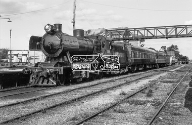 Eltham District Historical Society Inc
Photograph, Steam locomotive J-521 with the Royal Train at Echuca Railway Station during a visit by the new Governor of Victoria, His Excellency Sir Rohan Delacombe, c.May 1963
In this picture can be seen steam locomotive J-521 and tender to which is attached State Car No. 5. It is believed that the other support carriages have been de-attached and the train has pulled up at the front of the platform allowing room for other trains to pull in. Immediately behind on the same track at the platform is a Diesel Electric Rail Motor (DERM) and C-class bogey (luggage) then a small (articulated) rail car (articulated) then a cattle van. On the adjacent track is State Car No. 2 (Melville) and a C-van. State Car No. 2 (Melville) was used a power generation car for special trains and the Train of Knowledge. State Car No. 5 is in the design of the Spirit of Progress. George Coop advised that the occasion is the visit of the Governor of Victoria, Sir Rohan Delacombe to Echuca in 1963. Delacombe had replaced Sir Dallas Brooks in May 1963 who had departed for England on the liner Iberia,11 April 1963 (1963 'SIR DALLAS ON WAY TO U.K.', The Canberra Times (ACT : 1926 - 1995), 9 April, p. 9. , viewed 27 Jan 2020, http://nla.gov.au/nla.news-article104249252) George believes the Governor was doing a considerable formal train ride around the State and Echuca was on the schedule. The ‘platform’ was a special creation for such purposes, located on the wharf spur line that ran behind the Echuca Civic Centre. The large notice board commemorates the Queen’s visit on March 5th, 1954 for which the platform was initially built. From time to time it would get spruced up with pot plants, fresh paint and repaired hand rails for formal functions. George attended the Civic Reception held for the Governor. A picture of His Excellency Sir Rohan Delacombe, Governor of Victoria, and Lady Delacombe about to entrain at Spencer Street for a visit to western Victoria is available on page 4 of VICTORIAN RAILWAYS REPORT OF THE VICTORIAN RAILWAYS COMMISSIONERS FOR THE YEAR ENDED 30th JUNE, 1963. (http://www.victorianrailways.net/vr%20history/annual_reports/vrar1963.pdf) More information about the Victorian Railways Royal Train https://en.wikipedia.org/wiki/Victorian_Railways_Royal_Train State Car No. 5 https://www.pjv101.net/cd/pages/c160v06.htm State Car No. 2 (Melville) https://www.pjv101.net/cd/pages/c160v03.htmDigital TIFF file Scan of 35mm Ilford FP3 black and white negative transparencycattle van, c-van, diesel electric rail motor (derm), echuca, echuca rail yard, echuca railway station, george coop collection, governor of victoria, j-521, rail car, royal train, power car, sir rohan delacombe, state car no. 2 (melville), state car no. 5, train of knowledge, victorian railways -
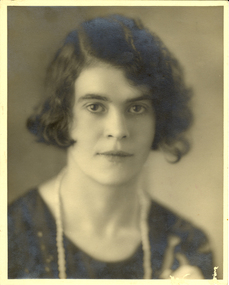 Federation University Historical Collection
Photograph - Photograph - black and white, Ivy Wilson, c1930
Ivy Wilson was the daughter of an orthopedic bootmaker 17 Mair Street, Ballarat. Ivy studied Art at the Ballarat School of Mines Technical Art School in 1920 - 1922. She later became an expert dressmaker. Her primary education was undertaken at Humffray Street State School. See http://victoriancollections.net.au/items/50651fd52162ef01087e8f50.1) A black and white photograph of the head and shoulders of a young woman - Ivy Wilson .2) Beasley Family Home associated with Ivy Wilson whose mother, Charlotte Beasley, is in the photograph. Left to right: John Lane, Frederick Beasley, Frederick Beasley Jnr (B. 1861)), Alexander Williamson, Annie Eaves, Jack Beasley (b. 1861), Frances, ?, Charlotte Beasley (B. 1873), Enoch Beasley (B. 1869), Harry Beasley (b. 1866), Thomas Eaves.]]ballarat school of mines, wilson, ballarat technical art school, dressmaking, art, ivy wilson -
 South West Healthcare
Carmalt's tongue holding forceps, Medical Equipment, ca 1920
Used for surgery in a mental health hospital in Victoria circa 1920. Positions the tongue of an unconscious patient forward; possibly used during tonsillectomies. May also have been used for patients with epilepsy. http://museumvictoria.com.au/collections/items/259059/carmalt-s-tongue-holding-forceps-medicon-metal-circa-1920Stainless steel forcep with punch arm and base with matching hole"STAINLESS STEEL", "F.G & D" "C.TURTIN & SONS. SHEFIELD"oral & tonsil instrument, mental health, epilepsy -
 Unions Ballarat
Diagnostic & Statistical Manual (DSM) - Psychiatry's Deadliest Scam, Citizens Commission on Human Rights International, 2011
The film is an exposé alleging that the DSM is used to justify psychiatric fraudulence and quackery. The DSM is portrayed as a highly contentious manual used by psychiatrists for diagnostic purposes. ALLEGATIONS are made in relation to how the guide may be used to unnecessarily medicate and manipulate patients. Also available online at: http://www.cchr.org/videos/diagnostic-statistical-manual.htmlRelevant to civil liberties, patient rights and the profession of psychiatry.DVDbtlc, ballarat trades hall, ballarat trades and labour council, dsm, diagnostic & statistical manual, psychiatry, psychiatrists, psychiatric diagnoses and treatment, patients - rights, mental illness, pharmaceutical companies, civil liberties -
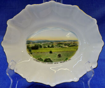 Orbost & District Historical Society
dish, 1950-1970
Small china pieces carrying scenic views of holiday destinations were a popular kind of souvenir during much of the 20th century. The pictures on the souvenirs ranged across natural beauty spots (beaches, waterfalls, rivers), civic buildings and monuments (town halls, war memorials), and indicators of local progress (commercial centres and occasionally even industrial sites). Ref: Powerhouse Museum Sydney.Small souvenir dish. White with gold edging and a picture of Orbost in bottom centre. Picture is a view from Grandview Heights. White, square, bone china dish with fluted rim trimmed with gold. In the centre of the dish there is a coloured transfer of a scene labelled as 'Sturt Street, Ballarat'. The scene shows grand Victorian buildings in the background, shops with verandahs and verandah posts lining one side of Sturt Street, trees on the other side of the street, and a tram in the foreground. A transfer on the underside gives manufacturer's information. Read more: http://www.powerhousemuseum.com/collection/database/?irn=12118#ixzz23rwkysrO Under Creative Commons License: Attribution Non-CommercialUnderneath- Royal Stafford -Bone China, Made in England, 3444 Top- Orbost From Grandview Heights, Vic.souvenir dish orbost grandview-heights crockery domestic stafford-royal -
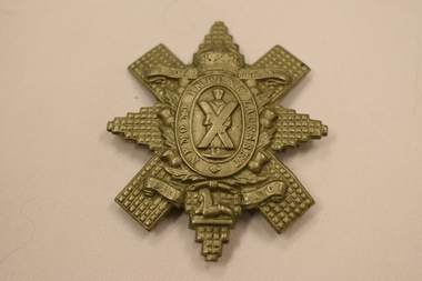 Dandenong/Cranbourne RSL Sub Branch
Cap Badge, Black Watch, 1902-1935
Cap Badge ,Black Watch, Royal Highlanders 1902-1935. Badge features a rayed and faceted star similar to the Star of the Order of Thistles. Upon the centre, within a wreath of thistles, an oval frosted circle bears the burnished motto: 'Nemo Me Impune Lacesset' ( Meaning no one attacks me with impunity) This is surmounted by a monarchial crown. Within the circlet the figure of St Andrew is depicted holding his cross on a frosted ground On either side of the crown bears ' The Royal Highlanders' . On the bottom of the badge a scroll with the words 'Black Watch". refer https://collection.nam.ac.uk/detail.php?acc=1963-12-74-1See "Description"