Showing 1290 items
matching lands
-
 Ringwood and District Historical Society
Receipt Books, North Ringwood Maroondah Hospital Auxiliary financial records and documents - 1967 to 1981, 1967-1981
Collection of note books and papers belonging to the North Ringwood Maroondah Hospital Auxiliary funds. Bank deposit books and record of term deposits - one for $1,000 and one for $3,112.19. Interest rate was 17% in 1982.Small Landseer note book - receipts and expenditure for the North Ringwood Maroondah Hospital Auxiliary 1967-1981; 3 RESI-Statewide Building Society deposit books; 2 term deposit notes for N.R.H.A. dated 1982 -
Bendigo Historical Society Inc.
Map - BAMAWM : COUNTY OF BENDIGO, 19-8-24
Map. Bamawm, County of Bendigo, Turrumberry, Pannoobamawm, Diggorra, Ballendella, Millewa. Photo-Lithographed at the Department of Lands and Survey, Melbourne by W.J. Butson, 19-8-24, Price 1/-. (number 50 in map cupboard 1)W.J. Butsonmap, bendigo, bamawm -
 Bendigo Historical Society Inc.
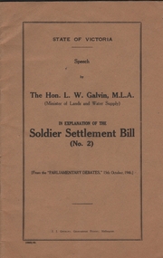
Book - SOLDIER SETTLMENT BILL (NO.2)
Twenty six pages booklet. State of Victoria - Speech by The Hon. L.W. Galvin M.L.A. (Minister of Lands and Water Supply) in Explanation ot the Soldier Settlment Bill (No. 2) from the Parliamentary Debates 15th October 1946.government, state, soldier settlment bill -
Lakes Entrance Historical Society
Book, Australian Aboriginal Culture, 1974
A revised edition of the brochure which accompanied the touring exhibition of Australian Aboriginal Culture promoted by UNESCO and funded by the Austalian government early 1950's. Briefly describes origins, dwellings, tribal lands, dress, hunting, toos anaboriginals -
 Bendigo Historical Society Inc.
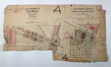
Map - LOCAL AREA PLANS, See above
Map: Compilation of maps: Town lots Bridgewater dated April 29 1871. Village of Colbinnabbin, dated 5 December 1866, Township of Axedale 1858 (Larritt). Suburban lands Axedale dated April 12 1871map, bendigo, parish plan, bridgewater, colbinnabbin, axedale, suburban lands -
 Bendigo Historical Society Inc.
Map - JACK FLYNN COLLECTION: ARCHDALE, 15/01/1936
Map: Parish of Archdale, County of Gladstone. Parish plan. The Allotments have been coloured in with pencil.By Authority H.J. Green, Government Printer Melbourne. Drawn and Reproduced at the Dept, of Lands and Survey, Melbourne, Victoria. 15/01/36map, gladstone, parish plan, archdale , gladstone -
Stawell Historical Society Inc
Map, Easton Johnstone, Map of Stawell Surveyed by Easton Johnstone 1872, 1872
Victoria Co Crushing Machine. St Georges Co Crushing machine. Wimmera Co Crushing Machine. Government Reservoir and Drainage. Sloan Street, Skene Street Mines. old Mine WorkingsA2 map of Stawell Reefs Area. Showing Crushing Machines & Title InfoSurveyed by Easton Johnstone Contract Surveyor. Photo-Lithographed at the Department of Lands & Survey. Melbourne By J Noone 9th May 1872mining -
Friends of Ballarat Botanical Gardens History Group
Work on paper - Plant Transportation, A Brief History, July, 2007
Plant transportation was important especially in establishing new gardens and in reminding those living in strange lands, of home.The transportation of plants from other parts of the world was important in establishing the Ballarat Botanical Gardens and other gardens in Australia.4 pages with subheadings on pp. 1-4.Nonejohn garner, doctor john garner, plant transportation, ballarat botanical gardens, friends of ballarat botanical gardens, the australian experience of plant transportation, ballarat experience of plant transportaion, john garner collection, gardens, ballarat -
 Mont De Lancey
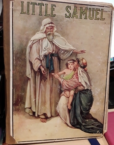
Book, John F. Shaw & Co. Ltd, Little Samuel : bible stories, Unknown
A collection of bible stories for young children Retold by Catherine Shaw.A young children's collection of Bible stories with an illustration of a man talking to a mother and her child on the front cover. The title, Little Samuel is printed at the top of the front cover in green text.fictionA collection of bible stories for young children Retold by Catherine Shaw.children's books, bible stories, children's fiction -
 Ringwood and District Historical Society
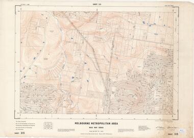
Map - Melbourne Metropolitan Area Base Map Series, Sheet 215 - Ringwood area, 1967
Map prepared by Dept of Lands and Survey and MMBW from State Aerial Survey June 1957 and Cadastral Survey information July 1967. This sheet comprises parts of Municipalities of Doncaster & Templestowe, Nunawading and Ringwood, and Parishes of Nunawading and Warrandyte.Scale: 400 feet to 1 inch. Contours at 5 feet vertical interval. By Authority: A.C. Brooks, Commonwealth Printer, Melbourne. -
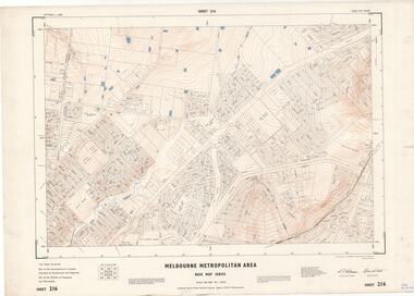 Ringwood and District Historical Society
Map - Melbourne Metropolitan Area Base Map Series, Sheet 216 - Ringwood area, 1967
Map prepared by Dept of Lands and Survey and MMBW from State Aerial Survey June 1957 and Cadastral Survey information July 1967. This sheet comprises parts of Municipalities of Croydon, Doncaster & Templestowe, and Ringwood, and Parishes of Ringwood and Warrandyte.Scale: 400 feet to 1 inch. Contours at 5 feet vertical interval. By Authority: A.C. Brooks, Commonwealth Printer, Melbourne. -
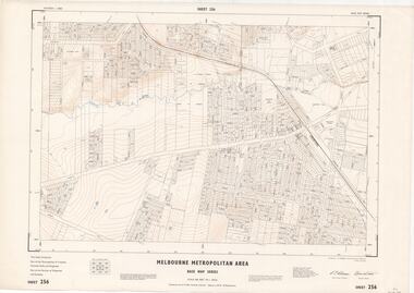 Ringwood and District Historical Society
Map - Melbourne Metropolitan Area Base Map Series, Sheet 256 - Ringwood area, 1962
Map prepared by Dept of Lands and Survey and MMBW from State Aerial Survey December 1956 and Cadastral Survey information December 1962. This sheet comprises parts of the Municipalities of Croydon, Ferntree Gully, and Ringwood, and Parishes of Ringwood and Scoresby.Scale: 400 feet to 1 inch. Contours at 5 feet vertical interval. By Authority: A.C. Brooks, Commonwealth Printer, Melbourne. -
Bendigo Historical Society Inc.
Map - NEILBOROUGH : COUNTY OF BENDIGO, 13-10-27
Map. Neilborough, County of Bendigo, Tandarra, Whirrakee, Huntly, Nerring, Yarraberb, Yallook, Photo-Lithographed at the Department of Lands and Survey, Melbourne by W.J. Butson 13-10-27, Price 1/- (number 77 in map cupboard 1)W.J. Butson.map, bendigo, neilborough -
Bendigo Historical Society Inc.
Map - MANDURANG : COUNTY OF BENDIGO, 1962
Map. Mandurang, County of Bendigo. Sandhurst, Strathfieldsaye, Sedgwick, Lockwood. By authority A.C. Brooks, Government Printer, Melbourne. Drawn and Reproduced at the Department of Lands and Survey, Melbourne, 1962, Price 2/-. (number 67 in map cupboard 1)A.C. Brooks, Government Printer, Melbourne.map, bendigo, mandurang -
Bendigo Historical Society Inc.
Map - TALAMBE : COUNTY OF BENDIGO, 21-3-27
Map. Talambe, County of Bendigo, Hayanmi, Calivil, Pompapiel, Yallook, Tandarra, Dingee. Photo-Lithographed at the Department of Lands and Survey, Melbourne, by W.J. Butson 21-3-27, Price 2/-. (number 27 in map cupboard 1)W.J. Butsonmap, bendigo, talambe -
Bendigo Historical Society Inc.
Map - CAMPBELL COLLECTION: BENDIGO AND DISTRICT MAPS, 11-2-37
Map. Parish of Shelbourne, County of Bendigo. Scale 40 chains to 1 inch. Drawn and reproduced at the Department of Lands and Survey, Melbourne, Victoria. Price 2/-.11-2-37. By Authority H.J. Green, Government Printer, Melbourne.H.J. Green, Government Printermap, bendigo, agricultural lands -
Bendigo Historical Society Inc.
Map - EPPALOCK : COUNTY OF BENDIGO, 2-11-14
Map. Eppalock, County of Bendigo,Lyell, Sedgwick, Strathfieldsaye, Axedale, Knowsley, Kimbolton. Photo-Lithographed at the Department of Lands and Survey, Melbourne by W.J. Butson, 2-11-14. Price 1/-. (number 39 in map cupboard 1)W.J. Butson.map, bendigo, eppalock -
Bendigo Historical Society Inc.
Map - YARRAYNE : COUNTY OF BENDIGO, 6-1-32
Map. Yarrayne, County of Bendigo, Janiember East; Pompapiel, Salisbury, Bridgewater, Salisbury West, Powlett. Photo-Lithographed at the Department of Lands and Survey, Melbourne. Price 2/-. 6-1-32. (number 12 in map cupboard 1)H.J. Green, Government Printermap, bendigo, yarrayne -
Bendigo Historical Society Inc.
Map - PANNOOMILLOO : COUNTY OF BENDIGO, 1957
Map. Pannoomilloo, County of Bendigo, Milloo, Warragamba, Diggorra, Pannoobamawm. Drawn and reproduced at the Department of Lands and Survey, Melbourne,1957. Price 2/-. By Appointment W.M. Houston, Government Printer, Melbourne. (number 3 in map cupboard 1)W.M. Houston, Government Printermap, bendigo, pannoomilloo -
 Bendigo Historical Society Inc.
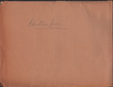
Document - MCCOLL, RANKIN AND STANISTREET COLLECTION: CHRISTMAS LEASE DOCUMENTS, 1941
Documents: folder contains - 'Consent to the Inclusion of Certain Lands in a Mining Lease', forms for Lease No. 11106, Map of No. 11106, List of land owners re: Lease 11106, Blank consent forms, Lease 11106 was below the 400foot level.MCCOLL RANKIN AND STANSISTREETorganization, business, gold mining, mccoll rankin and stansistreet, christmas gold mine. -
Bendigo Historical Society Inc.
Map - WANURP: COUNTY OF BENDIGO, 1/12/33
Map. Wanurp, County of Bendigo, Terrick Terrick East, Mitiamo, Dingee, Milloo, Pannoobamawm. L422+. Photo-Lithographed at the Department of Lands and Survey, Melbourne, Price 2/-. 1/12/33 ( number 411 in Map Cupboard 1 )H.J. Green, Government Printerbendigo, hospital -
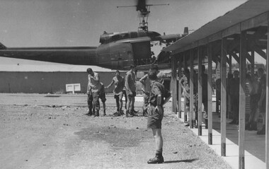 National Vietnam Veterans Museum (NVVM)
Photograph, Gibbons, Denis, Waiting for Incoming Dustoff 4
Denis Gibbons (1937 – 2011) Trained with the Australian Army, before travelling to Vietnam in January 1966, Denis stayed with the 1st Australian Task Force in Nui Dat working as a photographer. For almost five years Gibbons toured with nine Australian infantry battalions, posting compelling war images from within many combat zones before being flown out in late November 1970 after sustaining injuries. The images held within the National Vietnam Veterans Museum make up the Gibbons Collection.A black and white photograph of medics at the 1st Australian Field Hospital turn their heads to escape rotor wash as an American "Dustoff" medivac evacuation helicopter lands with a battle casuality. The Medics are ready to transfer the casavac to the hospital triage for assessment.photograph, 1st australian field hospital, vung tau, dustoff, medivac, gibbons collection catalogue, medics, wounded servicemen, denis gibbons -
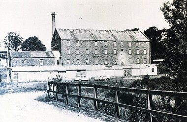 City of Ballarat Libraries
Photograph - Card Box Photographs, Anderson's Mill, Smeaton circa 1960
Acquired by the then Dept of Conservation Forests & Lands who restored the building & replaced long iron shed with timber veranda.anderson's mill, smeaton, building, manufacturing, vehicle -
Linton and District Historical Society Inc
Purchase Document, Grant By Purchase, Special Land Sale,1861: Sale of land to Henry Franks
The Allotment was purchased as part of a sale of Special Lands at Linton on the 9th of April 1861 The amount paid was £16 15s.Photocopy of a document which records the purchase by H. Franks of Allotment 15, Section 1, Township of Linton. henry franks, allotment 15 section 1 township of linton, special land sale 1861, documents and records -
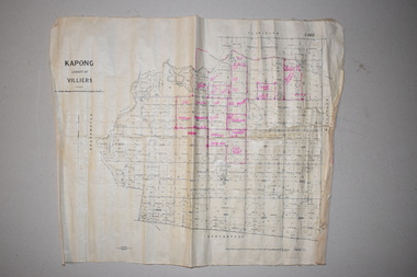 Warrnambool and District Historical Society Inc.
Maps (2), 1 Kapong .2 Hawkesdale, 1 1913 .2 1942
These two maps of the Kapong/ Hawkesdale area in Victoria show the original lands that belonged to the pioneer settler, Charles Hamilton MacKnight and the handwritten annotations that show the subsequent owners of these lands. Charles Hamilton Macknight (1819-1873) came to Australia from Scotland in 1841 and in 1842, with partners, James Irvine and William Campbell, established the property of Dunmore in Broadwater (24 kilometres from Hawkesdale). He was a prominent breeder of sheep, cattle and horses. Sections of his lands were acquired by the Baulch family and these maps were acquired from a member of the Baulch family, with Stanley Baulch being the possible annotator of the Kapong map. These maps are of interest as they show the properties that belonged to the pioneer settler, Charles Hamilton MacKnight and the subsequent division of these lands, some of these passing into the hands of the Baulch family. As the Kapong map also shows other original landowners, it will be a useful tool for researchers..1 This is a map of Kapong in the County of Villiers. It is on a rectangular-shaped piece of linen-backed paper with black printing and some handwritten annotations in red ink. It is crumpled at the edges. .2 This is a rectangular-shaped piece of paper showing a map of the Hawkesdale area. The printed material is in grid form in black, green and red. At the left bottom edge it has a mauve stamp. kapong, victoria, hawkesdale, victoria, dunmore estate, victoria, charles hamilton macknight, baulch family, western victoria, history of warrnambool -
 Creswick Campus Historical Collection - University of Melbourne
Map, Creswick, 1943
Dept of Lands and Survey map of Creswick and county of Talbot. 2 linen backed sheets rolled into white cardboard cylinderMaps -
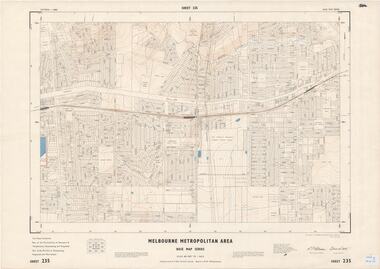 Ringwood and District Historical Society
Map - Melbourne Metropolitan Area Base Map Series, Sheet 235 - Ringwood area, 1960
Map prepared by Dept of Lands and Survey and MMBW from State Aerial Survey June 1957 and Cadastral Survey information August 1960. This sheet comprises parts of Municipalities of Doncaster & Templestowe, Nunawading and Ringwood, and Parishes of Nunawading, Ringwood and Warrandyte.Scale: 400 feet to 1 inch. Contours at 5 feet vertical interval. By Authority: A.C. Brooks, Commonwealth Printer, Melbourne. -
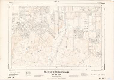 Ringwood and District Historical Society
Map - Melbourne Metropolitan Area Base Map Series, Sheet 255 - Ringwood area, 1963
Map prepared by Dept of Lands and Survey and MMBW from State Aerial Survey December 1956 and Cadastral Survey information May 1963. This sheet comprises parts of the Municipalities of Ferntree Gully, Nunawading and Ringwood, and Parishes of Nunawading, Ringwood and Scoresby.Scale: 400 feet to 1 inch. Contours at 5 feet vertical interval. By Authority: A.C. Brooks, Commonwealth Printer, Melbourne. -
Bendigo Historical Society Inc.
Map - RAVENSWOOD : COUNTY OF BENDIGO, 28-7-14
Map. Ravenswood, County of Bendigo, County of Talbot, Lockwood, Sutton Grange, Harcourt, Walmer, Bradford, Shelbourne, Mandurang, Photo-Lithographed at the Department of Lands and Survey by T.F. McGauran 28-7-14. (number 86 in map cupboard 1)T.F. McGauranmap, bendigo, ravenswood -
Bendigo Historical Society Inc.
Map - ROCHESTER WEST : COUNTY OF BENDIGO, 30-10-12
Map. Rochester West, County of Bendigo, Ballendella, Giggorra, Township of Rochester. Campaspe River. Photo-lithographed at the Department of Lands and Survey, Melbourne, by W.J. Butson 30-10-12. Price 1/-. (number 22 in map cupboard 1)W.J. Butson, Government Printer.map, bendigo, rochester west