Showing 5243 items
matching level
-
 Glenelg Shire Council Cultural Collection
Photograph - Photograph - Cape Grant Quarry, 03/09/1954
Port of Portland Authority ArchivesBack: Purple PHT stampport of portland archives, cape grant quarry -
 Halls Gap & Grampians Historical Society
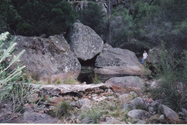
Photograph - Coloured, 24/04/2005
The photo shows a small weir on the Stoney Creek which used to supply water to a number of early businesses in Halls Gap, such as the general store and Grampians House. Each business ran a pipe from the weir to their premises and three outlets can still be seen embedded in the wall. Record 248 was taken at the same time.Photograph of a woman approaching a small weir with three large boulders behind it. The original level of the weir can be seen on the boulders. The additional image is a description of how to get to the weir.scenery, stoney creek -
 Federation University Historical Collection
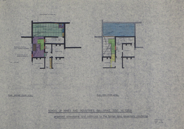
Plans, Preliminary Measured Drawings of the Former Gaol Governor's Residence Lydiard St, 1977
Four measured drawings on paper, with coloured shading: .1) Plan ground floor and first floor level .2) Proposed alterations and additions .3) as above .4) as abovegaol governor's residence, g. hewitt, smb, ballarat school of mines, architectural plans -
Glenelg Shire Council Cultural Collection
Photograph - Photograph - Alcoa berth, Portland Harbour, 1981
Port of Portland Authority ArchivesBack: PRE-CAST DECK SLABS 4 ALCOA WHARF 8.1.81 - pencilport of portland archives, alcoa berth, silos, portland harbour trust -
Bendigo Historical Society Inc.
Document - NEW CHUM & VICTORIA LINES OF REEF - NEW CHUM & VICTORIA MINE MANAGER'S REPORT
Handwritten notes on New Chum & Victoria formed 1870. Mentions machinery, working depth and levels. Number of men employed, loads of ore, amount of gold, profit and dividendsdocument, gold, new chum & victoria lines of reef, new chum & victoria lines of reef, new chum & victoria mine manager's report, new chum & victoria tribute -
Port Melbourne Historical & Preservation Society
Photograph - Unichema offices, Ingles Street, Port Melbourne, David Thompson, May 1996
Photos taken prior to moving offices from 1920s building to renovated factory around the cornerColour photo Unichema offices 164 Ingles Street (formerly J Kitchen & Sons) taken May 1996: View of interior: office partitioning from ground levelbuilt environment - commercial, business and traders - soaps/candles, david thompson -
Whitehorse Historical Society Inc.
Article, Turn Minor Upgrade to Major one, 2015
Blackburn traders are lobbying the State Government to rebuild the Blackburn Station underground when the level crossing is removed.Blackburn traders are lobbying the State Government to rebuild the Blackburn Station underground when the level crossing is removed, in order to unite the shopping centre north & south of the railway line.Blackburn traders are lobbying the State Government to rebuild the Blackburn Station underground when the level crossing is removed. blackburn village shopping centre, blackburn railway crossing, blackburn railway station -
Whitehorse Historical Society Inc.
Article, Family Digs In Over Land, 2016
The level crossing removal Authority intended to use a narrow strip of land next to the railway tracks in Heatherdale Road only to discover that it was privately owned and negotiations are proceeding with the owners.The level crossing removal Authority intended to use a narrow strip of land next to the railway tracks in Heatherdale Road only to discover that it was privately owned and negotiations are proceeding with the owners.The level crossing removal Authority intended to use a narrow strip of land next to the railway tracks in Heatherdale Road only to discover that it was privately owned and negotiations are proceeding with the owners.heatherdale railway station, level crossing removal authority -
 Whitehorse Historical Society Inc.
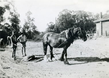
Photograph, St Lukes Vermont Tennis Working Bee, C1947
Black & white photograph of working bee making the tennis court in Grove Street Vermont, now the site of the Vicarage. In photo are Bruce & Ross Livermore with horse levelling the ground.st lukes tennis courts, livermore bruce, livermore ross -
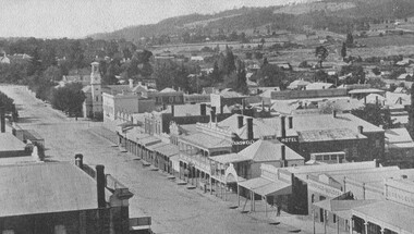
 Ballarat Tramway Museum
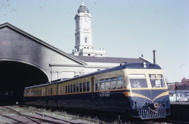
Slide - 35mm slide/s, Robert Thomson, 27/03/1964 12:00:00 AM
Yields information about the type of rail motor or rail car that served Ballarat's railway stations.Ilford Ilfochrome cardboard mount, colour slide of 280HP Rail motor at the Ballarat Railway Station, taken from the level crossing. Has the clock tower in the background, but no clock."Rail Motor, Ballarat Station - 37- 27/3/1964" in ink.tramways, trams, lydiard st north, railway station, railcar, ballarat station -
 Bayside Gallery - Bayside City Council Art & Heritage Collection
Sculpture - ceramic, Alnis Ansons, Brighton Council Chambers Mural, 1961
Alnis Ansons (1928-2015) was introduced to architect Kevin Knight in the lead-up to the opening of the Brighton Municipal Offices in 1961. The architect, on seeing some relief work in the artist’s home, asked Ansons if he would attempt an ambitious 70 square metre work within the council building which would wrap around the lift shaft of the three storey building. The tight deadlines and budgetary constraints imposed on the project impacted on the artist’s process but, in adapting to these limitations, Ansons developed a bold and original technique for producing commercial ceramic works. The mural, which symbolises the people of Brighton at work, worship and play, is constructed from hundreds of individual ceramic casts that have been treated with an engobe, similar to an underglaze, to produce a myriad of colours. The pieces were then fired only once, and grouted with copper grouting from top to bottom, creating a three-dimensional effect on the central column in the council chambers. Ansons was assisted during the installation by his future wife, Ralda, who was tasked with holding the pieces in position as they dried, to prevent them from sliding or shifting.Alnis Ansons, Brighton Council Chambers Mural 1961, ceramic. 750 x 595 cm. Bayside City Council Art and Heritage Collection. Commissioned c. 1960Circular ceramic relief mural around lift well in Brighton Council Chambers. The work begins on the ground floor of the Brighton Library, through to the mezzanine level up to the Chambers. mural, public art, alnis ansons, brighton council chambers, brighton library, ceramic, kevin knight, bayside chambers, bayside city council -
 Queen Victoria Women's Centre
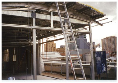
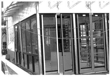
Photograph, August 1996
Colour photograph. Rooftop, level five facing north east looking at the frame and basic structure of what was to be the atrium. Ladder in centre of photo. Taken during restoration inspection. building construction, historic buildings -
 City of Kingston
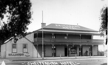
Photograph - Black and white, Percy Fairlam, Cheltenham Hotel - Keighrans, c. 1918
This image shows the importance of a reasonably large pub offering accommodation and a meeting place for a relatively small community in a regional area during the World War I (WWI) periodBlack and white image of Keighrans Hotel which is a two Storey building with a wrought iron balcony with a man standing at ground level with his bicycle and a big sign billiardsRound red sticker:X3 Handwritten in blue ink: A16 Handwritten in red ink 72% Handwritten in black ink: CHAP 4? / CHELTENHAM HOTEL / EXCHANGE HOTEL [crossed out] / Cheltenham / Pre WW [crossed out] about / WWI / BUILT ON THE SITE / of the ORIGINAL / CHELTENHAM INNcommerce, trade, hotel, pub, public house, cheltenham, world war i, first world war, wwi -
 Bendigo Historical Society Inc.
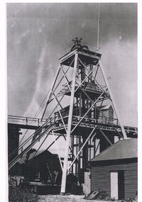
Photograph - NORTH DEBORAH POPPET HEAD
North Deborah Mine in Eve Street, Bendigo, operated between 1937 and 1954. In that time it produced 128,000 ounces of gold.Black and white photo of the North Deborah poppet head with associated buildings beside its feet. Name sign attached at level two has damage to the left side.mining, surface equipment, north deborah mine. -
 The Beechworth Burke Museum
Photograph, c1900
Taken in Beechworth c1920, this photograph was taken from the tower of Christ Church (Anglican) looking down at Ford Street. Black and white rectangular postcard. Obverse: Beautiful Beechworth (Vic) 1800 ft. above Sea Level- Ford Street (Looking East) Copyright. F Foxcroft Photo. Reverse: AO3104 Post Cardbeechworth, ford street, burke museum, post card, photograph, 1920, church tower, anglican church, church -
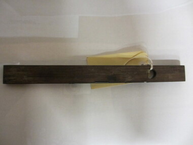 Seaworks Maritime Museum
Spirit Level
long wooden instrument with sealed glass tube containing liquid. With metal plate with moon and star design and writing.Attached tag, written in pencil: "SPIRIT LEVEL/ PWO 1488.1" Metal plate: "A MATHIESON & SON/ 21 C/ GLASGOW & EDINBURGH" written with white pen: "PWO 1488.1" -
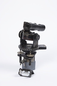 Nhill Aviation Heritage Centre
Instrument - Astro Compass Mk.II, c1940
This instrument was one of the type used for training night navigation at the Nhill Air SchoolBlack metal instrument with pivot points and white markings to 360 degrees. Telescope sighting piece and bubble level gauges and screw adjusters. Includes separate sight original fitting.AM Astro Compass Mk.II, REF 6A/1174, 4C astro compass, compass, instrument, navigation, cramer -
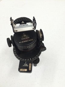 Nhill Aviation Heritage Centre
Instrument - Astro Compass
This instrument is the type used in the Nhill Air School navigation trainingBlack metal instrument with pivot points and white markings to 360 degrees. Telescope sighting piece and bubble level gauges and screw adjusters. Includes separate sight original fitting.AM, Astro Compass Mk.Ii, 6A/1174O, 4Pastro compass, navigation, instrument -
Glenelg Shire Council Cultural Collection
Photograph - Photograph - Cape Grant Quarry, n.d
Port of Portland Authority Archives -
Glenelg Shire Council Cultural Collection
Photograph - Photograph - Cape GRant Quarry, Portland, n.d
Port of Portland Authority Archivesport of portland archives, cape grant quarry, harbour development -
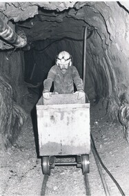 Bendigo Historical Society Inc.
Photograph - CENTRAL DEBORAH GOLD MINE, 1985 ?
Black and white photograph of underground mining scene, showing helmeted male with wheeled skip on rails. Level 2 Centrel Deborah Gold Mine 1985 ( j. Lerk 11.2.2000 )organization, business, central deborah gold mine -
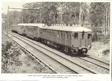 Bendigo Historical Society Inc.
Photograph - BASIL MILLER COLLECTION: DOUBLE DECK TRAILER CAR
Black and white photograph of new double deck (tri Level) tailer car which had just been introduced on Sydney Suburban railway. Probably clipped from a magazine.person, individual, basil miller -
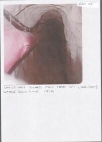 Bendigo Historical Society Inc.
Photograph - KEN BICE COLLECTION: WATTLE GULLY GOLD MINE
Laminated, faded colour photograph. Image shows stope with air lines. On bottom of image: ' looking east towards main shaft No. 1 level, Wattle Gully Mine 1979'mining, equipment, wattle gully gold mine -
Bendigo Historical Society Inc.
Document - PUBLIC OFFICE DRAWINGS: BENDIGO
Six photocopied undated draftsman drawings of New Public Offices Sandhurst. [Post office] Upstairs, ground level, basement, front and rear side elevations along with clock tower.bendigo, buildings, state public offices -
Port Melbourne Historical & Preservation Society
Plan - Proposed bridge under Hobsons Bay railway at Clarendon Street, Emerald Hill, 1854 - 1884
Plan of proposed bridge under Hobson's Bay Railway at Clarendon Street, Emerald Hill, affecting Sandridge railway and Sandridge Road. Flood level re Sandridge line is shown.transport - railways, flood, emerald hill, town planning -
Whitehorse Historical Society Inc.
Article, Talks on Crossings, 2015
The Victorian State Government has signed the contracts for the renewal of the Blackburn and Heatherdale Roads level crossings.The Victorian State Government has signed the contracts for the renewal of the Blackburn and Heatherdale Roads level crossings. However Blackburn traders are seeking improvements to facilitate easier pedestrian traffic movements.The Victorian State Government has signed the contracts for the renewal of the Blackburn and Heatherdale Roads level crossings. blackburn railway crossing, heatherdale railway crossing, railway crossings -
 Whitehorse Historical Society Inc.
Photograph, Brittania Street, 13/06/1986 12:00:00 AM
2 Coloured photos of Britannia Street looking South towards Whitehorse Road.Prior to the redevelopment of Britannia Mall and construction of 3 level carpark. The present Post Office is seen in the background.britannia street mitcham -
 Queen Victoria Women's Centre
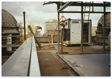
Photograph, c.1996
Black and white photograph. Level five taken from rooftop area towards what is the Atrium when it was being constructed. Walls and windows are erected. Taken during restoration inspection. historic buildings, building construction, cultural structures and establishments -
 Queen Victoria Women's Centre
Photograph, c.1996
Colour photograph. Level 5 and rooftop. taken on the eastern side of floor, facing south towards Lonsdale street. Only the basic structure is erected. Taken during restoration inspection. building construction, historic buildings, cultural structures and establishments -
 Lakes Entrance Regional Historical Society (operating as Lakes Entrance History Centre & Museum)
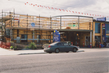
Photograph, M Holding, 28/09/2007 12:00:00 AM
Colour photograph of Heyfield Motel and Apartments taken during additions to building showing scaffolding around building and framing in place for upper level, 115 Esplanade Lakes Entrance Victoriaaccommodation