Showing 1093 items matching "mini-computer"
-
 Port Melbourne Historical & Preservation Society
Document - Manuscript, Shirley Margaret Hart Hellier, Shirley Hellier, 'Shirl's World', 2004
Draft manuscript 'Shirl's World 1934-1961' by Shirley Margaret Hart Hellier, covering her Port Melbourne experience until marriage, including her overseas travel. 106pp of computer printout held by bulldog clip.domestic life, families, shirley margaret hellier, albert street -
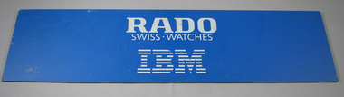 Tennis Australia
Court barrier, Circa 1988
A court barrier used during a tennis tournament, advertising IBM and Rado, providers of the computer technology and the stadium timepieces, respectively, during that event. Inscription: RADO/SWISS - WATCHES/IBM. Materials: Fibreboard, Paint, Adhesive labeltennis -
Federation University Art Collection
Book - Artist's Book, Mann, Allan, 'Confined Fires' by Allan Mann, 1998
This item is part of the Federation University Art Collection. The Art Collection features over 2000 works and was listed as a 'Ballarat Treasure' in 2007.Red hard covered book with images from numerous sources which have been collaged, scanned, and manipulated on computer before being ink-jet printed in an edition of twenty two, utilising Zerkan and Toshi papers. 16/22art, artwork, allan mann, printmaking, artist's book -
 Bacchus Marsh & District Historical Society
Map, Gorrockburkchap Parish Map, County of Grant c.1915
The parish of Gorrockburkchap (sometimes spelled Gorrockburkghap) lies to the west and south west of the township of Bacchus Marsh. The locality of Rowsley is situated within this parish area.A single page paper map showing the parish plan for Gorrockburkchap in the County of Grant. The map is pasted into a bound volume containing 76 maps or plans in total. High resolution digital image stored on BMDHS computer network. gorrockburkchap parish maps, rowsley victoria maps -
 Bacchus Marsh & District Historical Society
Map, Gorrockburkchap Parish Map, County of Grant
The parish of Gorrockburkchap (sometimes spelled Gorrockburkghap) lies to the west and south west of the township of Bacchus Marsh. The locality of Rowsley is situated within this parish area.A single page paper map showing the parish plan for Gorrockburkchap in the County of Grant. The map is pasted into a bound volume containing 76 maps or plans in total. High resolution digital image stored on BMDHS computer network. gorrockburkchap parish maps, rowsley victoria maps -
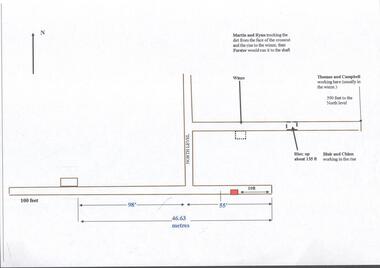 Bendigo Historical Society Inc.
Plan - Great Extended Hustlers, April, 2014
Seven men were killed at the Great Extended Hustler's mine disaster on 2nd May 1914 by an explosion of dynamite occurring as the men were waiting at the plat to ascend the mine at the end of their shift. No blame was attached to anyone in the findings of the inquisition. It was unknown what caused the dynamite to explode. This document formed part of the research done at the time by Bendigo Historical Society, of the 100 years commemoration of the mine disaster, held at Hustler's Hill in 2014. One page plan, computer generated, annotated to show the worksite of the miners prior to when the explosion occurred at the Great Extended Hustlers mine in May 1914. The location of Martin, Ryan, Thomas, Campbell, Blair and Chinn are described. great extended hustlers, goldmining, accident, 1914 -
Tatura Irrigation & Wartime Camps Museum
List, New Caledonian Descendants, 2005
Borrowed for copying to computer, during visit by a group of New Caledonian descendants of internees in Camp 4 and the donor who was interned from Thursday Island to Camp 4.documents, reports -
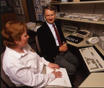
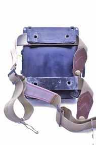 Montmorency–Eltham RSL Sub Branch
Equipment - Navigational Computer
Rectangular calculating instrument with (1) 'hinged lid' fitted with circular rotating dial for setting/reading altitude, speed, distance and temperature, (2) notebook inside lid, (3) circular dial with perspex cover, beneath which is (4) graph chart, moveable up-and-down by means of rotating knob on side of device. Curved brackets and elasticized straps on back for strapping onto pilot's leg.R.A.A.F. Ident. No. G6B/145 Serial No. WG/2233 COMPUTER NAVIGATIONAL Mk. III D. (Other inscriptions including instructions for use and scales for various measurements) "AB" hand written on strap (owner's initials?) -
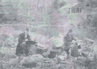
Tatura Irrigation & Wartime Camps Museum
Photograph, Dunera internee Firestone interviewed
1-12."Dunera" internee Firestone interviewed about his experiences in camp- original copy scanned for computer.|13-16 Photos on Ardmona orchard c.1942 -
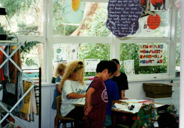 Sunbury Family History and Heritage Society Inc.
Photograph, Bulla Primary School - Portable classroom, c1993
The four children are working with their teacher Barbara Springfield who was on the staff at Bulla Primary School in 1993. It was a time before computers and other related devices were used in classrooms.A non-digital photograph of four children in a classroom standing at a table with their teacher. A lot of the children's work folders are displayed on a rack on the LHS and other items are displayed on the window and overhead. barbara springfield, bulla primary school, classroom activities -
 Vision Australia
Photograph - Image, Robin Pleydell with female staff member and client
Robin Pleydell looks on as an AFB worker reads from a Braille volume whilst sitting in front of a computer, and also with a vision impaired older woman working on a piece of pottery.Col. transparencies of Robin Pleydell in a pottery class and at a workdesk.association for the blind, robin pleydell -
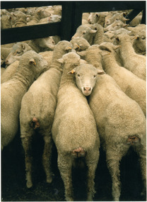 National Wool Museum
Photograph
Photo was taken on location of the filming of the mini series "The Dunera Boys". The photographer was Paul Baitz who was an extra working amongst the sheep in the pen on a freezing cold December day. Taken: ?December 1984. (this photo appears in a circular format on the title page of "Wool and the Australian Imagination") -
 Bacchus Marsh & District Historical Society
Map, Plan of part of the road district of Bacchus Marsh circa 1856-1862
Local government in much of Victoria including the Bacchus Marsh area began with the formation of 'local committees'. These local committees could make representations to a Central Road Board regarding plans for road construction. Road construction and maintenance were seen as the essential tasks of these early local government authorities. By 1856 the local committee in Bacchus Marsh was constituted as the Bacchus Marsh Road District. This entity continued until 1862 when the name changed to the Bacchus Marsh and Maddingley Road District. This new entity lasted until 1871 when the local government authority in accordance with new statewide legislation became known as the Shire of Bacchus Marsh. The title of this plan being a plan of 'a portion of the road district of Bacchus Marsh' suggests that the plan was produced sometime between 1856 and 1862. The main purpose of this map was to shown the irrigable land in the district and the sources from which water for irrigation could be drawn. Bacchus Marsh was an early irrigation district in Victoria. Irrigation trusts were formed in the 1880s and 1890s to manage irrigation districts. But this was the culmination of many years of earlier attempts to construct irrigation systems in the Bacchus Marsh area and create a system to manage irrigation more broadly. This map dating from around 1856-1862 is an important cartographic document which provides evidence of how the early planning for irrigation was developing in the Bacchus Marsh region.A single page paper map showing a plan of part of the road district of Bacchus Marsh. The map is pasted into a bound volume containing 76 maps or plans in total. High resolution digital image stored on BMDHS computer network. bacchus marsh victoria maps, bacchus marsh road district, local government, road districts, irrigation -
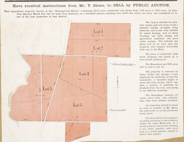 Bacchus Marsh & District Historical Society
Map, Bullengarook Estate Property Sale. 1911
Bullengarook is a locality located 19 kilometers north of Bacchus Marsh. Pastoral leases for European colonists were granted to people for this area from around the 1840s.The Bullengarook Estate was part of these early pastoral holdings. By the 1900s the property had been owned by the Skene family for a number of years. In early 1911 the property then consisting of 300 acres and the homestead upon it was offered for sale in one lot. It appears however that the sale of the property did not go through in 1911. It was later leased by Thomas Skene to a Mr Coutts in 1915 and ultimately and at a later stage the property was sold by the Skene family.A single page paper map showing land allotments for sale from the Bullengarook Estate. The map is pasted into a bound volume containing 76 maps or plans in total. High resolution digital image stored on BMDHS computer network. land sales bacchus marsh, bullengarook land sales, bullengarook estate, bullengarook vic history -
 Bendigo Historical Society Inc.
Photograph - PORTRAIT - SHIRLOW AND HUDSPETH
Negative Photograph of John SHIRLOW and John HUDSPETH, both drawing, sitting on the bank of a creek/water way, behind the men high up on the bank, a brick building and looks like a timber shed. On computer check SHIRLOW was a artist.Bartlett Bros. Bendigo.photograph, portrait, john shirlow. john hudspeth. -
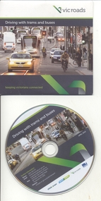 Melbourne Tram Museum
Film - Compact Diskette with video, VicRoads, "Driving with trams and buses", 2011
243.1 - Compact Diskette - CD - plastic contained within a light card cover, titled "Driving with trams and buses" produced by VicRoads to give information to motor car and truck drivers about driving with trams and buses. Produced in association with Yarra Trams, c2011. Has on the rear contract details. Part of the think tram project. 2nd copy added 3/8/2013 along with 243.2 243.2 - Mini CD/DVD (80mm diameter) in a cardboard folder, titled "Driving with Trams" - two copies held. 3rd copy added 11/6/2022 from an unknown source. See Reg Item 2416 for a pamphlet with similar materials. Mini CD/DVD copied onto the AV file database.trams, tramways, vicroads, yarra trams, compact disc cd, motor vehicles, motor buses -
Moorabbin Air Museum
Manual (Item) - RAAF Publication No.2 - Vocabulary Of Stores
Description: 250 pages. Published by Litton Industries Inc. Published November 1967. F-4D Inertial Navigation and Weapon Release Computer Systems Handbook Level of Importance: World. -
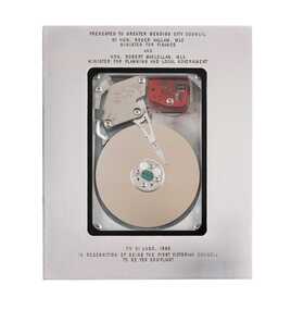 City of Greater Bendigo - Civic Collection
Equipment - Y2K Hard drive, Australian Government, 1999
Y2K / the year 2000 / The millennium bug / was commonly used to refer to a widespread computer programming shortcut that was expected to cause extensive havoc as the year changed from 1999 to 2000. Instead of allowing four digits for the year, many computer programs only allowed two digits (e.g., 99 instead of 1999). As a result, there was immense panic that computers would be unable to operate at the turn of the millennium when the date descended from "99" to "00". The Bug presented a formidable challenge to the problem-solving skills of local government officials. Lacking a cure-all that will work for every municipality, local officials must develop their own solutions to meet their community's unique needs. At the same time, the Y2K bug provided a once-in-a-millennium leadership opportunity for local officials who understood that they are the key to preparing their communities for any issues.Hard drive mounted in an alaminium case with glass window front and back.Presented to Greater Bendigo City Council / by Hon, Roger Hallam. MLC / Minister for Finance / and / Hon, Robert Maclellan. MLA / Minister for Planning and Local Government / on 21 June. 1999 / In recognition of being the first Victorian Council / to be Y2k compliantmillennium bug -
 Bendigo Military Museum
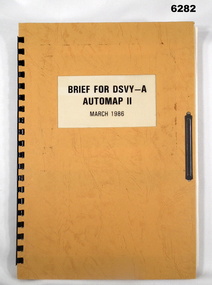
Administrative record - Brief for DSVY-A Automap 2 - March 1986, RJ McHenry Major for CO, 14 September 1987
Automap 2 is the second phase of a 3 phase project to introduce a computer assisted cartographic drafting system into service capable of capturing, storing and manipulating and outputting topographic data in digital form.A4 Folder, Orange Cardboard Cover, plastic ring bounding, "Arnos" fastener, text and diagramsroyal australian survey corps, rasvy, fortuna, army survey regiment, army svy regt, asr -
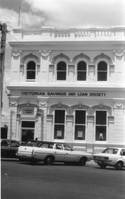 Stawell Historical Society Inc
Photograph, Victorian Savings & Loan Society in Main Street
Photograph of Victorian Savings & Loan Society. When built was the premises of Victorian State Savings Bank. Victorian Savings and Loan Society conducted their business there. In 2005 WestVic Computers occupy the building.Black and white photograph of a two story brick building with parapet top. Cement rendered arches over window. The building has 3 windows and a main entrance on the ground floor. The second story has 4 arched windows. Three cars are parked along the street in foreground.Victorian Savings and Loan Society stawell business -
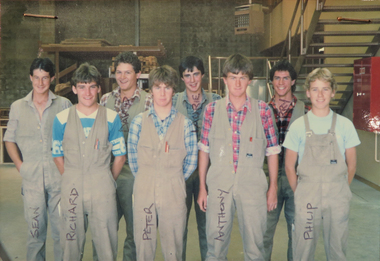 Federation University Historical Collection
Booklet, Education Department Victoria Technical Schools Register of Attendances in Pre-Apprenticeship, 1986, 1986
Blue hard covered book with red tape spine. It includes attendances for pre-apprenticeship students in Joinery. The instructor was D. Hawkes, B. Jacobson, and B. Whittle. Includes a photograph, and a computer printout of the class, their student Identification number and address.joinery, ballarat school of mines, trades, pre-apprenticeship, richard cocks, philip judd, lauri mceldrew, anthony mcmanus, david morris, peter richards, sean simpson, terry simpson, keith hancock, phillip judd, d. hawkes, b. jacobson, b. whittle -
 Bacchus Marsh & District Historical Society
Map, Bacchus Marsh Tuesday 23rd Oct. 1888, Lodge & Dunn's Paddocks 1888. Business and Mansion Sites
This map was created as a plan for an auction of land close to the Bacchus Marsh Railway Station. The auction took place on 23 October 1888. 102 allotments of land from an area known as Lodge and Dunn's paddocks was offered for sale. The auction was conducted by auctioneers based in Melbourne and was advertised in Melbourne newspapers as well as in the Bacchus Marsh Express newspaper. The auction plan contains a range of details including the selling agents, Munro and Baillieu; W.P. Lockhart; and John Turner, all of Melbourne, deposit terms for purchases, price of railway passes for a return trip from Melbourne to Bacchus Marsh of 1 shilling, and a description of the land as having 'magnificent views and perfect drainage'. A single page paper map showing allotments of land for sale along the Parwan Road in Maddingley. The map is pasted into a bound volume containing 76 maps or plans in total. High resolution digital image stored on BMDHS computer network. At bottom on left side: 'Harston & Co. Lith, Melb.'land sales bacchus marsh, land sales maddingley, bacchus marsh victoria maps, maddingley victoria maps -
 Bacchus Marsh & District Historical Society
Map, Bacchus Marsh Suburban Allotments Parwan Road Lodge & Dunn's Paddocks 1888
This map was created as a plan for an auction of land close to the Bacchus Marsh Railway Station. The auction took place on 23 October 1888. 102 allotments of land from an area known as Lodge and Dunn's paddocks was offered for sale. A single page paper map showing allotments of land for sale along the Parwan Road in Maddingley. The map is pasted into a bound volume containing 76 maps or plans in total. High resolution digital image stored on BMDHS computer network. land sales bacchus marsh, land sales maddingley, bacchus marsh victoria maps, maddingley victoria maps -
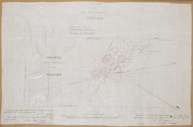 Bacchus Marsh & District Historical Society
Map, Plan of the Village of Melton
A single page paper map showing a plan for the village of Melton, Parish of Djerriwarrh, County of Bourke. The map is pasted into a bound volume containing 76 maps or plans in total. High resolution digital image stored on BMDHS computer network. melton victoria maps -
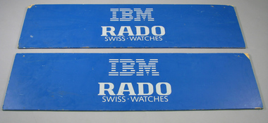 Tennis Australia
Court barrier, Circa 1988
Two court barriers (.1 - .2) used during a tennis tournament, advertising IBM and Rado, providers of the computer technology and the stadium timepieces, respectively, during that event. Inscription: IBM/RADO/SWISS - WATCHES. Materials: Fibreboard, Paint, Adhesive labeltennis -
 Bacchus Marsh & District Historical Society
Map, Tracing of plan shewing portion through Bacchus Marsh District of proposed new Main Road between Gisborne and Blackwood
Road construction and planning was a primary function of the early local government authorities in rural and regional Victoria. This plan is indicative of the sort of documentation which generated considerable public interest and comment in rural communities. The date of this plan is not clear. Newspaper articles in the Bacchus Marsh Express around 1869 contain numerous references to the proposed new road between Gisborne and Blackwood which suggests this plan may date from the late 1860s or early 1870s.A single page paper map showing the proposed route of a main road to be constructed between Gisborne and Blackwood. The map is pasted into a bound volume containing 76 maps or plans in total. High resolution digital image stored on BMDHS computer network. roads, road plans, bacchus marsh victoria maps, gisborne to blackwood main road -
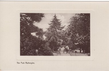 Rutherglen Historical Society
Image, The Park Rutherglen, c1900
A computer screen-print, from the eBay website, advertising this postcard for sale, was found filed with our photographs. Not recognising it as one already held, Martha Valentine purchased the card from eBay and donated it to the collection.Early black and white photograph of Rutherglen Park, printed on a postcard. A horse and cart and a bicyclist are on a path between large trees, with a very large pine tree at the centre of the photograph.At foot of photo: "The Park Rutherglen." On back of card, in the space for a message, is written: "Springhurst, Monday May 15th", and the card is addressed to "Miss Ivy Blackwood, Castella St, Healesville, Victoria"rutherglen park -
 Bendigo Historical Society Inc.
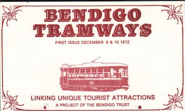
Document - JAMES LERK COLLECTION: BENDIGO TRAMWAYS POSTCARDS
Bendigo Tramways (mini) ' Postcards' - two with advertising for R O Henderson (Beehive) Pty Ltd, Pall Mall on reverse (both individually numbered); other two 'postcards' have nothing printed on reverse. Text on front: Bendigo Tramways. First Issue December 9 & 10 1972; Linking Unique Tourist Attractions; A Project of the Bendigo Trust.bendigo, tramways, tickets -
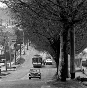 Ballarat Tramway Museum
Photograph - Digital image, Peter Bruce, "No. 11 Setting down.", 1970s
Yields information about the Mt Pleasant route and Barkly St.Digital image, black and white, of No. 11 in Barkly St, out bound to Mt Pleasant setting down passengers. Tram has a Twin Lakes sign. Mini Minor motor car in the front of the tramcar. Photo taken by Peter Bruce 1970's and 1971, prior to the closure of the Ballarat tramway system. Peter's Title of image: "No. 11 Setting down."trams, tramways, barkly st, mt pleasant, tram 11 -
![Newspaper Clipping - Digital Image, Lost in cyberspace [Greensborough Primary School Gr2062], 19/03/1996](/media/collectors/4f729f5697f83e03086015b8/items/5bb970a521ea6716dc2ede78/item-media/5bb970cf21ea6716dc2f0a7d/item-fit-380x285.jpg) Greensborough Historical Society
Greensborough Historical SocietyNewspaper Clipping - Digital Image, Lost in cyberspace [Greensborough Primary School Gr2062], 19/03/1996
Sharon Marmo, science and technology teacher at Greensborough Primary School discusses computers and education. In 1996 Greensborough Primary School hosted a technology symposium to assist educators from several schools to understand the new technology.Newspaper clipping, black and white text and colour image.greensborough primary school, computers in education, sharon marmo