Showing 868 items
matching path
-
 Stawell Historical Society Inc
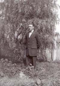
Photograph - Collection of Photos, Fisher Street: Family circa end of WW1
End of WW1 1917 -1918 - Family lived in Fisher Street. copies of 18 B/W Photos taken in yard near fence line of Path some have Peppercorn Tree. Family with pet dogs. Most men have Poppy on lapels. Geoff Bullock purchased Glass Slide Photos in garage sale in Fisher Street Stawell in early 2000'sOne man standing in grass wearing a bow tie in front of a tree and wooden fence. -
 Stawell Historical Society Inc
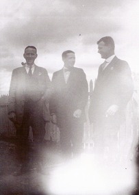
Photograph - Collection of Photos, Fisher Street: Family circa end of WW1
End of WW1 1917 -1918 - Family lived in Fisher Street. copies of 18 B/W Photos taken in yard near fence line of Path some have Peppercorn Tree. Family with pet dogs. Most men have Poppy on lapels. Geoff Bullock purchased Glass Slide Photos in garage sale in Fisher Street Stawell in early 2000'sThree men standing outside in front of wooden fence, the man on right smoking a pipe. -
 Stawell Historical Society Inc
Photograph - Collection of Photos, Fisher Street: Family circa end of WW1
End of WW1 1917 -1918 - Family lived in Fisher Street. copies of 18 B/W Photos taken in yard near fence line of Path some have Peppercorn Tree. Family with pet dogs. Most men have Poppy on lapels. Geoff Bullock purchased Glass Slide Photos in garage sale in Fisher Street Stawell in early 2000'sThree people standin outside in front of wooden fence, two men standing either sideof a Woman. -
 Stawell Historical Society Inc
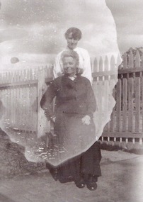
Photograph - Collection of Photos, Fisher Street: Family circa end of WW1
End of WW1 1917 -1918 - Family lived in Fisher Street. copies of 18 B/W Photos taken in yard near fence line of Path some have Peppercorn Tree. Family with pet dogs. Most men have Poppy on lapels. Geoff Bullock purchased Glass Slide Photos in garage sale in Fisher Street Stawell in early 2000'sTwo women outside one seated, the other standing behind. -
 Stawell Historical Society Inc
Photograph - Collection of Photos, Fisher Street: Family circa end of WW1
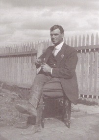
End of WW1 1917 -1918 - Family lived in Fisher Street. copies of 18 B/W Photos taken in yard near fence line of Path some have Peppercorn Tree. Family with pet dogs. Most men have Poppy on lapels. Geoff Bullock purchased Glass Slide Photos in garage sale in Fisher Street Stawell in early 2000'sOne Man Sitting outside on a chair with fence in background. -
 Stawell Historical Society Inc
Photograph - Collection of Photos, Fisher Street: Family circa end of WW1
End of WW1 1917 -1918 - Family lived in Fisher Street. copies of 18 B/W Photos taken in yard near fence line of Path some have Peppercorn Tree. Family with pet dogs. Most men have Poppy on lapels. Geoff Bullock purchased Glass Slide Photos in garage sale in Fisher Street Stawell in early 2000's -
 Stawell Historical Society Inc
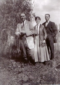
Photograph - Collection of Photos, Fisher Street: Family circa end of WW1
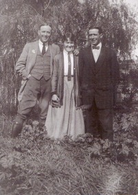
End of WW1 1917 -1918 - Family lived in Fisher Street. copies of 18 B/W Photos taken in yard near fence line of Path some have Peppercorn Tree. Family with pet dogs. Most men have Poppy on lapels. Geoff Bullock purchased Glass Slide Photos in garage sale in Fisher Street Stawell in early 2000'sTwo Men Standing either side of a female, tree and fence in the background. -
 Stawell Historical Society Inc
Photograph - Collection of Photos, Fisher Street: Family circa end of WW1
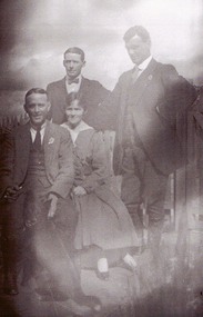
End of WW1 1917 -1918 - Family lived in Fisher Street. copies of 18 B/W Photos taken in yard near fence line of Path some have Peppercorn Tree. Family with pet dogs. Most men have Poppy on lapels. Geoff Bullock purchased Glass Slide Photos in garage sale in Fisher Street Stawell in early 2000'sFour People, three men and one lady. two men standing behind, the oher two seated. -
 Stawell Historical Society Inc
Photograph - Collection of Photos, Fisher Street: Family circa end of WW1
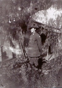
End of WW1 1917 -1918 - Family lived in Fisher Street. copies of 18 B/W Photos taken in yard near fence line of Path some have Peppercorn Tree. Family with pet dogs. Most men have Poppy on lapels. Geoff Bullock purchased Glass Slide Photos in garage sale in Fisher Street Stawell in early 2000'sA Male in Soldiers unofrom under a tree with a house in the Background. -
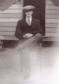 Stawell Historical Society Inc
Photograph - Collection of Photos, Fisher Street: Family circa end of WW1
End of WW1 1917 -1918 - Family lived in Fisher Street. copies of 18 B/W Photos taken in yard near fence line of Path some have Peppercorn Tree. Family with pet dogs. Most men have Poppy on lapels. Geoff Bullock purchased Glass Slide Photos in garage sale in Fisher Street Stawell in early 2000'sOne yong Man wearing a flat cap Sitting outside on a chair with wooden builing in background. -
 Vision Australia
Audio (item) - Sound recording, Royal Victorian Institute for the Blind, Around the Institute: August 14, 2001
Around the Institute was a weekly program designed to keep clients and staff informed of events, activities and thoughts relating to low vision and blindness. It consisted of interviews undertaken by Jo Matthews, with sound engineer Ed Gamble, designed to inform, educate and explore on a variety of topics. August 14: Pre-literacy skills – Beth Glover, My path through Employment Services – Illona Harty.royal victorian institute for the blind, radio shows -
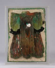 Ararat Gallery TAMA
Mixed media, Inga Hunter, The Forest People Robe of the Keeper of the Pathwa, 1986-1989
“The Keeper of Pathways is a simple, secular office. Her job involves the maintaining of routes through and within the forests, and the lighting of night paths. She keeps a team of designers, workers and artificers, who must constantly strive to keep the wayrights free from invading undergrowth, so that they may admit safe and well-lit passage for all travellers. Not an exciting job, but one which is vital to communication between groups, and to the general safety of Forest dwellers. The forest paths (wayrights) are lit by strings of small lights made from a species of glowing fungus, which is specially cultivated in the mountain caves. A whole team of workers is responsible for the growth of the light fungus, taking shifts as a public duty. No Forest Dweller like caves, so the shift-work is shared out as a public service, one which each person must carry out at regular times, dictated by the clerks of the Keeper of the Pathways.”-Inga Hunter -
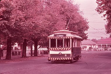 Ballarat Tramway Museum
Slide - 35mm slide/s - set of 2 - Bendigo 6, Noel Simons, Apr. 1967
Set of 2 slides made from the Association of Railway Enthusiast Provincial Tramways film strip, possibly during April 1967. 1191.1 - No. 6 heading for North Bendigo in Bridge St., just past the disused Bridge St. Loop. See item 9449 for a print of this photo. 1191.2 - Bendigo 16 and 17 in the depot. Photo taken inside the building. No. 16 showing Thorpe St., 17 - Depot.1191.1 - "No. 6 passes the disused Bridge St. loop on its path to North Bendigo" - dated with a hand stamp in purple ink "Apr 1967". 1191.2 - "No. 16 and 17 at rear of Bendigo Depot". - slide not dated - late 60's or early 70's. Details are in blue ink written onto slide mount.tramways, trams, north bendigo, bendigo, bridge st loop, depot, tram 6, tram 16, tram 17 -
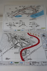 Kiewa Valley Historical Society
Plans - Southern Hydro - Bogong Power Development
Southern Hydro owned the Kiewa Hydro Electric Scheme in May 2006 when these plans were created. The Site No. 1 and Site No. 2 are part of the Bogong Power Development Bogong Power Development is part of the Kiewa Hydro Electric SchemeLaminated A3 plans mostly black and white but with a little color and surrounded by a grid.(Also see KVHS 1439) 1. Tunnel and Civil works / Commissioners Lodge Site Plan 1: Site No. 1 / TBN /Water /Supply / Reservoir Site 2. Tunnel and Civil Works / Pedestrian Diversion Access Paths / and Tracks: Site No. 2 / Lake Guy Site / Bogong Victoriabogong power development, southern hydro 2006 -
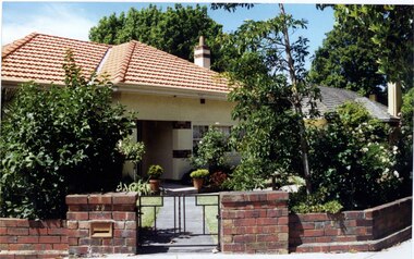 Glen Eira Historical Society
Photograph, Dalny Road, 23, Murrumbeena, 2001
Originally labelled "Beauville Estate, Established 1936, Still Thriving 65 years on, 10th March 2001", the Beauville Estate Album contains colour photographs of houses in the Estate. They were taken around the time of the Beauville Estate’s 65th Heritage Celebration held on 10/03/2001 and donated to the Caulfield Historical Society shortly afterwards. Photographer unknown. City of Glen Eira’s Heritage Management Plan Vol 2 p79 (this is p84 of the pdf version) – HO12 Beauville Estate and environs, Murrumbeena: The Beauville Historic Area is important at the State level as the first large housing estate undertaken by the AV Jennings Construction Co, later Jennings Group Limited, Victoria’s largest home builder. It is important also as a very early estate development incorporating a range of features other than houses and including made roads, shops and recreation facilities. In this respect it was the forerunner of the comprehensively planned housing estate of the post war era. The estate is distinguished by its aesthetic values, as is the earlier and comparable Hillcrest Estate, which are formed by a combination of restrained diversity in house styles, with the exception of no. 30 in the emerging International style, and by a landscaped garden environment. Colour photograph of a cream rendered brick house with unpainted decorative variegated brown brick features including on the porch and chimney. Other features include tiled roof, sash windows, concrete path, garden pots, established garden and a low unpainted lighter variegated brown brick fence in the foreground with '23' on the left hand pillar beside the black cast iron work gate. 23murrumbeena, houses, architectural styles, 1930's, inter war style, a.v. jennings, av jennings, jennings, brick houses, beauville estate, dalny road, porches, brick features, sir albert victor jennings, a v jennings construction co, beauville estate heritage area, glen eira city council, architectural features, jennings group limited, land subdivision, gardens, beauville historic area, chimneys, sash windows, brick fences, cast iron work gates, rendered houses -
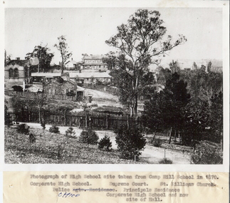 Bendigo Historical Society Inc.
Photograph - HIGH SCHOOL SITE, TAKEN FROM CAMP HILL SCHOOL, 1870
Black and white photograph of high school site taken from Camp Hill School in 1870, looking North East. Inscriptions: Identification of buildings typed on attached paper. Far left is the Corporate High School, the Police Office is the long building, the Supreme Court building at read and the Principal's residence towards the foreground. The vegetation and path in the front is now part of the Camp Hill Primary School.place, landscape view -
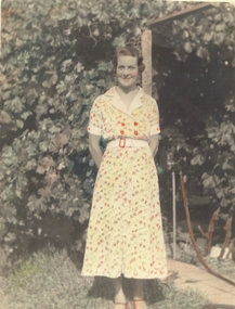 Bendigo Historical Society Inc.
Photograph - FEMALE PORTRAIT: V. TOGNO, 1936
black and white hand coloured photo, mature female in floral frock, against garden greenery, tap and hose to right of photo. Cement path. 'From Viola Togno, Mandurang' in ink. Xmas 1936. 'To johnnie from his mum ( faint black lead pencil ) Written in ink on back : To Mr and Mrs Dowsey, with fond love from (smudged) Auntie May, 19.11.06unknownperson, individual, female - violet togno, dowsey, with fond love from ….. (smudged ) auntie may -
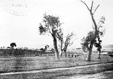 Surrey Hills Historical Society Collection
Photograph, Surrey Hills Golf Club - looking towards Doncaster, 1902, 1902
Reproduced by permission of Mr John Arnold from his book: "The Riversdale Golf Club - a history, 1892-1977." Copyright to book: Riversdale Golf Club. Surrey Hills Golf Club operated from 1892-1908 then moved and became Riversdale Golf Club. The game was played across paddocks from Trafalgar Street, Mont Albert to Whitehorse Road and down Victoria Crescent to where Box Hill TAFE is now located in Elgar Road. There were problems with cows eating the tee flags! The clubhouse still exists as 30 Trafalgar Street.This image is important for reference to the landscape and vegetation prior to urbanisation.Black and white photo in the foreground of which is a path running diagonally from left to right. Behind are 5 mature trees whose condition is not vigourous (showing signs of die-back). Several figures are beneath the trees, behind which is a post-and-wire fence, paddocks and distant houses. There is the shadow of a stamp in the top LH corner, suggestive of this having been copied from an earlier image.Caption: "Top: Looking towards Doncaster from the links in 1902."sports grounds, surrey hills golf club, riversdale golf club, john arnold -
 Whitehorse Historical Society Inc.
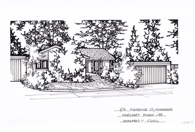
Artwork, other - Ink Line Drawing, Margaret Picken, 5/16 Florence St., Nunawading, 1993
A property illustration by Margaret Picken Commissioned by a real estate agency for the purpose of advertising 5/16 Florence St., Nunawading Made by using Rotring ‘Rapidigraph’ drafting pens with Rotring ink on Rapidigraph polyester drafting film, double matte. Trained as a cartographic draftsman within the mining industry, Margaret Picken is an artist who worked producing property illustrations for real estate agencies in eastern suburbs of Victoria from 1983-2005. Retiring from the industry as technological changes favored coloured photography over illustrations, and commissioning companies over sole contractors.This artwork is of Historical Significance as a record of local domestic architecture.A black ink line drawing on drafters film by Margaret Picken, of a black and white line drawing of a single story brick house with a path leading to the front door, from the public footpath. To the right is the separate garage. Trees and shrubs grow in garden beds in front of the buildings and in the background, while in front of the house is a front lawn. There are two holepunch holes centred just under the upper edge.5/16 Florence St., Nunawading Margaret Picken - 93 Woodards - C'wellwhitehorse historical society, schwerkolt cottage, housing, architecture, margaret picken, house, garden, real estate, nunawading -
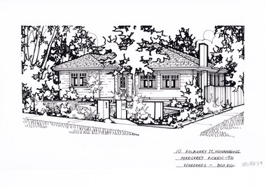 Whitehorse Historical Society Inc.
Artwork, other - Ink Line Drawing, Margaret Picken, 10 Holberry St., Nunawading, 1992
A property illustration by Margaret Picken Commissioned by a real estate agency for the purpose of advertising 10 Holberry St., Nunawading. This property is listed as having sold for $139,000 in 1992 Made by using Rotring ‘Rapidigraph’ drafting pens with Rotring ink on Rapidigraph polyester drafting film, double matte. Trained as a cartographic draftsman within the mining industry, Margaret Picken is an artist who worked producing property illustrations for real estate agencies in eastern suburbs of Victoria from 1983-2005. Retiring from the industry as technological changes favored coloured photography over illustrations, and commissioning companies over sole contractors.This artwork is of Historical Significance as a record of local domestic architecture.A black ink line drawing on drafters film by Margaret Picken, of a black and white line drawing of a right hand side corner block single story weatherboard house with a footpath from the corner leading to the front door. At the start of the path are two pillars, one serving as a letterbox. The front yard is edged with garden beds. There are two hole punch holes on just under the upper edge.10 Holberry St., Nunawading Margaret Picken - 92 Woodards - Boxhillwhitehorse historical society, schwerkolt cottage, housing, architecture, margaret picken, house, garden, real estate, nunawading -
 Bendigo Historical Society Inc.
Photograph - T C WATTS & SON COLLECTION: BENDIGO HOUSE, ca. 1930
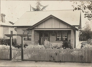
BHS CollectionBlack and white photographs (2) mounted on rectangular brown board. House, weatherboard, verandah with pillars. Picket fence with gateway lintel: corrugated iron roof, path on R.H.S of house established garden. On back: Mrs. O'Shannessy £725. In pencil ' sold' T.C. Watts stamp on rear. On front : Frank A. Jeffree, Photos, Bendigo. 24b. Same as above, with date 27 April 1929.Frank A. Jeffree, Bendigoresidential, mrs. o'shannessy, t.c. watts and son, frank a. jeffree -
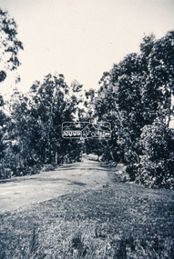
 Eltham District Historical Society Inc
Slide - Photograph, Unidentified location, Eltham district, c.Aug. 1990
Part of a presentation, "Roads and Byways of the Shire of Eltham", by Russell Yeoman to the 12 September 1990 Society meeting. Slides shown included copies of old photos and recent images ranging from the suburban streets of Eltham and Montmorency to the mountain roads of Kinglake. In the byways category are views of some iof the Shire's bicycle paths including then recently completed sections of the Main Yarra Trail at Lower Plenty.35mm colour positive transparency (1 of 37) Mount - Agfachrome Agfa CS System black 8 dotseltham, infrastructure, roads, unidentified -
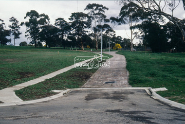
 Eltham District Historical Society Inc
Slide - Photograph, Near the old Lower Plenty Bridge (present day Edward Willis Court), c.Aug. 1990
Part of a presentation, "Roads and Byways of the Shire of Eltham", by Russell Yeoman to the 12 September 1990 Society meeting. Slides shown included copies of old photos and recent images ranging from the suburban streets of Eltham and Montmorency to the mountain roads of Kinglake. In the byways category are views of some iof the Shire's bicycle paths including then recently completed sections of the Main Yarra Trail at Lower Plenty.35mm colour positive transparency (1 of 37) Mount - Agfachrome Agfa CS System black 8 dotsinfrastructure, roads, edward willis court, lower plenty, lower plenty bridge -
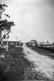
 Eltham District Historical Society Inc
Slide - Photograph, Main Road, Eltham, c.1910, c.Aug. 1990
Part of a presentation, "Roads and Byways of the Shire of Eltham", by Russell Yeoman to the 12 September 1990 Society meeting. Slides shown included copies of old photos and recent images ranging from the suburban streets of Eltham and Montmorency to the mountain roads of Kinglake. In the byways category are views of some iof the Shire's bicycle paths including then recently completed sections of the Main Yarra Trail at Lower Plenty.35mm colour positive transparency (1 of 37) Mount - Agfachrome Agfa CS System black 8 dotsinfrastructure, roads, main road, eltham -
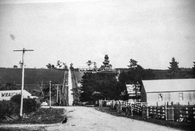
 Eltham District Historical Society Inc
Slide - Photograph, Eltham-Yarra Glen Road, Kangaroo Ground c.1910, c.Aug. 1990
Part of a presentation, "Roads and Byways of the Shire of Eltham", by Russell Yeoman to the 12 September 1990 Society meeting. Slides shown included copies of old photos and recent images ranging from the suburban streets of Eltham and Montmorency to the mountain roads of Kinglake. In the byways category are views of some iof the Shire's bicycle paths including then recently completed sections of the Main Yarra Trail at Lower Plenty.35mm colour positive transparency (1 of 37) Mount - Agfachrome Agfa CS System black 8 dotsinfrastructure, roads, eltham-yarra glen road, kangaroo ground -
 Eltham District Historical Society Inc
Slide - Photograph, Unidentified location, Eltham district, c.Aug. 1990
Part of a presentation, "Roads and Byways of the Shire of Eltham", by Russell Yeoman to the 12 September 1990 Society meeting. Slides shown included copies of old photos and recent images ranging from the suburban streets of Eltham and Montmorency to the mountain roads of Kinglake. In the byways category are views of some iof the Shire's bicycle paths including then recently completed sections of the Main Yarra Trail at Lower Plenty.35mm colour positive transparency (1 of 37) Mount - Agfachrome Agfa CS System black 8 dotsinfrastructure, roads, houses, private street scheme, residential, unidentified -
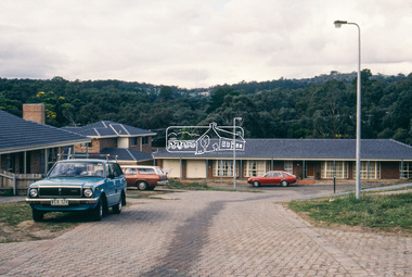
 Eltham District Historical Society Inc
Slide - Photograph, Aerial Photo (c.1987): Main Road, Eltham from Pitt Street to Elsa Court, c.Aug. 1990
Part of a presentation, "Roads and Byways of the Shire of Eltham", by Russell Yeoman to the 12 September 1990 Society meeting. Slides shown included copies of old photos and recent images ranging from the suburban streets of Eltham and Montmorency to the mountain roads of Kinglake. In the byways category are views of some iof the Shire's bicycle paths including then recently completed sections of the Main Yarra Trail at Lower Plenty.35mm colour positive transparency (1 of 37) Mount - Agfachrome Agfa CS System black 8 dotsinfrastructure, roads, aerial photographs, alistair knox park, bridge street, central park, diamond street, elsa court, eltham, eltham common, eltham railway station, eltham town park, main road, pitt street -
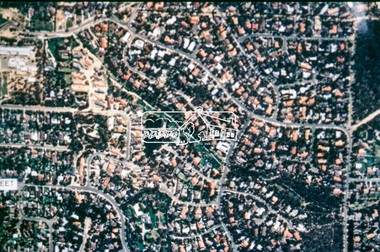 Eltham District Historical Society Inc
Slide - Photograph, Aerial Photo (c.1987): Woodridge Estate, Eltham, c.Aug. 1990
Part of a presentation, "Roads and Byways of the Shire of Eltham", by Russell Yeoman to the 12 September 1990 Society meeting. Slides shown included copies of old photos and recent images ranging from the suburban streets of Eltham and Montmorency to the mountain roads of Kinglake. In the byways category are views of some iof the Shire's bicycle paths including then recently completed sections of the Main Yarra Trail at Lower Plenty.35mm colour positive transparency (1 of 37) Mount - Agfachrome Agfa CS System black 8 dotsinfrastructure, roads, aerial photographs, eltham, housing estate, woodridge estate