Showing 467 items matching "photographs / slides / film"
-
 Bendigo Military Museum
Photograph - Royal Australian Survey Corps - Map Production Processes, c1990
This is a collection of 20 photographs of Royal Australian Survey Corps phases of map production at the School of Military Survey, Bonegilla, the Army Survey Regiment, Bendigo, and the Army Map Depot, Bandiana circa 1990. Colour photos are on 35mm slide film and were scanned at 96 dpi. They are part of the Army Survey Regiment’s Collection. Photo .1P was probably taken on a survey station overlooking Lake Hume near Albury-Wodonga. The field party occupying the survey station was likely from a Map Control Survey course conducted by the School of Military Survey, Bonegilla. This survey station was part of a geodetic network used in field survey training and RASvy’s Lake Hume Test Range. Photos .3P to .16P were taken at the Army Survey Regiment, Bendigo and photos .17P & .18P were taken at the Army Map Depot, Bandiana. Photo .19P depicts a map of RASvy’s ARA units before the disbandment of 5th Field Survey Squadron, Perth and 2nd Field Survey Squadron, Sydney in 1990. This is a collection of 20 photographs of map production processes taken at the School of Military Survey, Bonegilla, the Army Survey Regiment, Bendigo, and the Army Map Depot, Bandiana circa 1990. Colour photos are on 35mm slide film and were scanned at 96 dpi. They are part of the Army Survey Regiment’s Collection. Photo .2P is printed on photographic and scanned at 300 dpi. .1) – Photo, colour, c1980s. Geodetic Surveying: AN/PRR-14 Geoceiver antenna on hill surrounding Lake Hume. Series 3 Land Rover, field party tent and survey station beacon in background. .2) – Photo, black & white, c1980s. Geodetic Surveying: AN/PRR-14 Geoceiver antennas set up at the School of Military Survey, Bonegilla, Victoria. .3) – Photo, colour, c1990. Aerotriangulation: Wild PUG4 point transfer device, SSGT Bruce Hammond. .4) – Photo, colour, c1990. Aerotriangulation: Zeiss (Jena) Stecometer, SSGT Bruce Hammond. .5) – Photo, colour, c1990. Aerotriangulation: computer tape maintenance, SSGT Noel McNamara. .6) – Photo, colour, c1990. AUTOMAP 2: computer tape maintenance, SPR Nadine (Paul) Read. .7) - Photo, colour, c1990s. AUTOMAP 2: Optronics 4040 scanning/film output in Lithographic Squadron, SGT Sherri (Dally) Burke. .8) - Photo, colour, c1990s. AUTOMAP 2: Benson verification plotter output, SPR Nadine (Paul) Read. .9) – Photo, colour, c1990. Aerotriangulation: data management, SGT Neil ‘Ned’ Kelly. .10) & .11) - Photo, colour, c1990s. AUTOMAP 2: Wild B8 Aviograph stereoplotter Feature Extraction, unidentified technician. .12) - Photo, colour, c1990s. AUTOMAP 2: Graphic Edit Workstation, SPR Nadine (Paul) Read. .13) - Photo, colour, c1990s. AUTOMAP 2: Graphic Edit Workstation, SPR Dawn Hoadley. .14) & .15) - Photo, colour, c1990s. AUTOMAP 2: Graphic Edit Workstation, unidentified technician. .16) – Photo, colour, c1990s. Heidelberg Speedmaster 102 computer-controlled five colour lithographic offset printing press. .17) & .18) – Photo, colour, c1990s. Army Map Depot, unidentified storeman, Bandiana. .19) – Photo, colour, c1990. RASvy ARA Unit Locations before disbandment of field units in Perth and Sydney. .20) – Photo, colour, c1990. Set of overlapping aerial photography..1P, .3P to .20P - Some equipment is identified on the frame of the 35mm slides.royal australian survey corps, rasvy, army survey regiment, army svy regt, fortuna, asr, school of military survey, army map depot -
 Eltham District Historical Society Inc
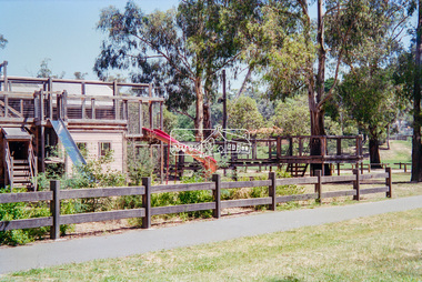
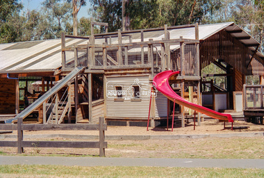
Negative - Photograph, Eltham North Adventure Playground, Wattletree Road, Eltham, 1998c
A community group project steered by Bambi McLean led to the construction of the Eltham North Adventure Playground which opened off Wattletree Road in 1995. The structure was mainly wooden and included an undercover element with slides and areas to climb. It was destroyed by fire in 2017. A new adventure playground was built in 2018.Roll of 35mm colour negative film, 8 strips and associated 10 x 15 cm colour printKodak Gold 100-5north eltham, north eltham adventure playground, wattletree road -
 Eltham District Historical Society Inc
Negative - Photograph, Eltham North Adventure Playground, Wattletree Road, Eltham, 1998c
A community group project steered by Bambi McLean led to the construction of the Eltham North Adventure Playground which opened off Wattletree Road in 1995. The structure was mainly wooden and included an undercover element with slides and areas to climb. It was destroyed by fire in 2017. A new adventure playground was built in 2018.Roll of 35mm colour negative film, 8 strips and associated 10 x 15 cm colour printKodak Gold 100-5north eltham, north eltham adventure playground, wattletree road -
 Ballarat Heritage Services
Photograph, Clare Gervasoni, Ballarat's Link with Pioneering in the Australian Film Industry, 05/02/2023
Photographs relating to Ballarat's Link with Pioneering in the Australian Film Industry. Near the spot depicted, in 1891, Captain Joseph Perry of the Salvation Army operated a Prison Gate Brigade Home on a rented property on Barley Street Ballarat East (since demolished). In the house he cared for prisoners who had been released from the Ballarat Gaol.. He also set up the Social Reform Wing photographic studio, and was it's sole operator. He used his photographic skills to publicise his work and to raise money. He also produced glass lantern slides. As part of the Salvation Army's Limelight department Joseph Perry produced "Sodiers of the Cross" (1900) and for the Australian Government Fedeation films in 1901, bith considered pioneer films in Australia.salvation army, joseph perry, prison gate brigade home, social reform wing photographic studio, barkly street ballarat east, pioneer films -
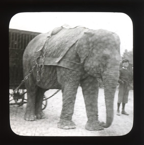
 The Beechworth Burke Museum
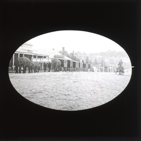
Photograph - Lantern Slide, c1900
This slide depicts an image of elephants from a travelling circus being marched through Camp Street in Beechworth in the early 1900s. Travelling circuses began operation in Australia in the 1860s as a way of providing entertainment to towns across Australia. Many of these traveling circuses use to have exotic animals such as elephants as part of their performances. Lantern slides, sometimes called 'magic lantern' slides, are glass plates on which an image has been secured for the purpose of projection. Glass slides were etched or hand-painted for this purpose from the Eighteenth Century but the process became more popular and accessible to the public with the development of photographic-emulsion slides used with a 'Magic Lantern' device in the mid-Nineteenth Century. Photographic lantern slides comprise a double-negative emulsion layer (forming a positive image) between thin glass plates that are bound together. A number of processes existed to form and bind the emulsion layer to the base plate, including the albumen, wet plate collodion, gelatine dry plate and Woodburytype techniques. Lantern slides and magic lantern technologies are seen as foundational precursors to the development of modern photography and film-making techniques.This glass slide is significant because it provides insight into Beechworth's social amenities and religious infrastructure in the late Nineteenth Century. It is also an example of an early photographic and film-making technology in use in regional Victoria in the time period.Thin translucent sheet of glass with an oval image printed on the front and framed in a black backing. It is held together by metals strips to secure the edges of the slide.burke museum, beechworth, lantern slide, slide, glass slide, plate, burke museum collection, photograph, monochrome, circus, travelling circus, elephants, circus elephants, exotic animals, 1900s, entertainment -
 The Beechworth Burke Museum
Photograph - Lantern Slide, c1900
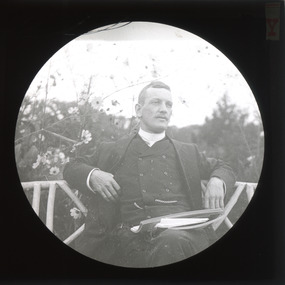
This image showing a man sitting on a bench seat reveals what life was like in the Edwardian era through the clothing and hairstyle worn by the seated man. Lantern slides, sometimes called 'magic lantern' slides, are glass plates on which an image has been secured for the purpose of projection. Glass slides were etched or hand-painted for this purpose from the Eighteenth Century but the process became more popular and accessible to the public with the development of photographic-emulsion slides used with a 'Magic Lantern' device in the mid-Nineteenth Century. Photographic lantern slides comprise a double-negative emulsion layer (forming a positive image) between thin glass plates that are bound together. A number of processes existed to form and bind the emulsion layer to the base plate, including the albumen, wet plate collodion, gelatine dry plate and woodburytype techniques. Lantern slides and magic lantern technologies are seen as foundational precursors to the development of modern photography and film-making techniquesThis glass slide is significant because it provides insight into Beechworth's social amenities and religious infrastructure in the late Nineteenth Century. It is also an example of an early photographic and film-making technology in use in regional Victoria in the time period.Thin translucent sheet of glass with a circular image printed on the front and framed in a black backing. It is held together by metals strips to secure the edges of the slide.burke museum, beechworth, lantern slide, slide, glass slide, plate, burke museum collection, photograph, monochrome, edwardian era, portrait -
 The Beechworth Burke Museum
Photograph - Lantern Slide, c1900
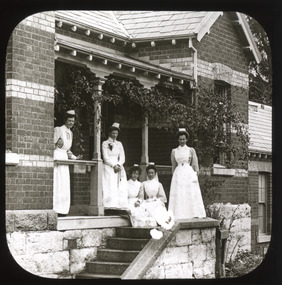
This image shows 5 nurses of Mayday Hills Mental Asylum gathered on the porch and staircase of a building. Beechworth has a long history of nursing, beginning with the establishment 3 medical facilities in the mid-1800s, the Ovens District Hospital (opened in 1857), the Ovens Benevolent Asylum (opened in 1863), and the Mayday Hills Hospital (opened in 1867). Lantern slides, sometimes called 'magic lantern' slides, are glass plates on which an image has been secured for the purpose of projection. Glass slides were etched or hand-painted for this purpose from the Eighteenth Century but the process became more popular and accessible to the public with the development of photographic-emulsion slides used with a 'Magic Lantern' device in the mid-Nineteenth Century. Photographic lantern slides comprise a double-negative emulsion layer (forming a positive image) between thin glass plates that are bound together. A number of processes existed to form and bind the emulsion layer to the base plate, including the albumen, wet plate collodion, gelatine dry plate and Woodburytype techniques. Lantern slides and magic lantern technologies are seen as foundational precursors to the development of modern photography and film-making techniquesThis glass slide is significant because it provides insight into Beechworth's social amenities and religious infrastructure in the late Nineteenth Century. It is also an example of an early photographic and film-making technology in use in regional Victoria in the time period.Thin translucent sheet of glass with a square image printed on the front and framed in a black backing. It is held together by metals strips to secure the edges of the slide.burke museum, beechworth, lantern slide, slide, glass slide, plate, burke museum collection, photograph, monochrome, nurses, nursing, mayday hill hospital -
 The Beechworth Burke Museum
Photograph - Lantern Slide, c1900
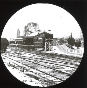
This slide shows an image taken in c.1900 of the Beechworth Railway Station. The Beechworth Railway Station was officially opened on the 29 of September 1876, to allow for quicker and easier transportation of goods and supplies from Beechworth to Melbourne via Everton and Wangaratta. The railway station was heavily used for transportation running two trains a day and was a vital link to Melbourne from it's opening until it's closure in 1976. Lantern slides, sometimes called 'magic lantern' slides, are glass plates on which an image has been secured for the purpose of projection. Glass slides were etched or hand-painted for this purpose from the Eighteenth Century but the process became more popular and accessible to the public with the development of photographic-emulsion slides used with a 'Magic Lantern' device in the mid-Nineteenth Century. Photographic lantern slides comprise a double-negative emulsion layer (forming a positive image) between thin glass plates that are bound together. A number of processes existed to form and bind the emulsion layer to the base plate, including the albumen, wet plate collodion, gelatine dry plate and Woodburytype techniques. Lantern slides and magic lantern technologies are seen as foundational precursors to the development of modern photography and film-making techniquesThis glass slide is significant because it provides insight into Beechworth's social amenities and religious infrastructure in the late Nineteenth Century. It is also an example of an early photographic and film-making technology in use in regional Victoria in the time period.Thin translucent sheet of glass with a circular image printed on the front and framed in a black backing. It is held together by metals strips to secure the edges of the slide.burke museum, beechworth, lantern slide, slide, glass slide, plate, burke museum collection, photograph, monochrome, beechworth railway station, railway station, transport, railway history, railway -
 The Beechworth Burke Museum
Photograph - Lantern Slide, c1900
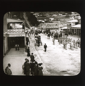
This image taken in c.1900 shows a military parade marching along Camp Street in Beechworth heading towards the center of town, watched my onlookers lining the sidewalks. Lantern slides, sometimes called 'magic lantern' slides, are glass plates on which an image has been secured for the purpose of projection. Glass slides were etched or hand-painted for this purpose from the Eighteenth Century but the process became more popular and accessible to the public with the development of photographic-emulsion slides used with a 'Magic Lantern' device in the mid-Nineteenth Century. Photographic lantern slides comprise a double-negative emulsion layer (forming a positive image) between thin glass plates that are bound together. A number of processes existed to form and bind the emulsion layer to the base plate, including the albumen, wet plate collodion, gelatine dry plate and Woodburytype techniques. Lantern slides and magic lantern technologies are seen as foundational precursors to the development of modern photography and film-making techniquesThis glass slide is significant because it provides insight into Beechworth's social amenities and religious infrastructure in the late Nineteenth Century. It is also an example of an early photographic and film-making technology in use in regional Victoria in the time period.Thin translucent sheet of glass with a square image printed on the front and framed in a black backing. It is held together by metals strips to secure the edges of the slide.burke museum, beechworth, lantern slide, slide, glass slide, plate, burke museum collection, photograph, monochrome, military parade, military, australian military, 1900s, early 20th century -
 The Beechworth Burke Museum
Photograph - Lantern Slide, c1900
Image taken in c.1900 of Albert Road, Beechworth, showing surrounding landscape. Lantern slides, sometimes called 'magic lantern' slides, are glass plates on which an image has been secured for the purpose of projection. Glass slides were etched or hand-painted for this purpose from the Eighteenth Century but the process became more popular and accessible to the public with the development of photographic-emulsion slides used with a 'Magic Lantern' device in the mid-Nineteenth Century. Photographic lantern slides comprise a double-negative emulsion layer (forming a positive image) between thin glass plates that are bound together. A number of processes existed to form and bind the emulsion layer to the base plate, including the albumen, wet plate collodion, gelatine dry plate and Woodburytype techniques. Lantern slides and magic lantern technologies are seen as foundational precursors to the development of modern photography and film-making techniquesThis glass slide is significant because it provides insight into Beechworth's social amenities and religious infrastructure in the late Nineteenth Century. It is also an example of an early photographic and film-making technology in use in regional Victoria in the time period.Thin translucent sheet of glass with a square image printed on the front and framed in a black backing. It is held together by metals strips to secure the edges of the slide.burke museum, beechworth, lantern slide, slide, glass slide, plate, burke museum collection, photograph, monochrome, 1900s, landscape, streetscape, albert road -
 The Beechworth Burke Museum
Photograph - Lantern Slide, c1900
This image was taken c.1900 and shows one of the offices upstairs in the Beechworth Town Hall. Lantern slides, sometimes called 'magic lantern' slides, are glass plates on which an image has been secured for the purpose of projection. Glass slides were etched or hand-painted for this purpose from the Eighteenth Century but the process became more popular and accessible to the public with the development of photographic-emulsion slides used with a 'Magic Lantern' device in the mid-Nineteenth Century. Photographic lantern slides comprise a double-negative emulsion layer (forming a positive image) between thin glass plates that are bound together. A number of processes existed to form and bind the emulsion layer to the base plate, including the albumen, wet plate collodion, gelatine dry plate and Woodburytype techniques. Lantern slides and magic lantern technologies are seen as foundational precursors to the development of modern photography and film-making techniquesThis glass slide is significant because it provides insight into Beechworth's social amenities and religious infrastructure in the late Nineteenth Century. It is also an example of an early photographic and film-making technology in use in regional Victoria in the time period.Thin translucent sheet of glass with a square image printed on the front and framed in a black backing. It is held together by metals strips to secure the edges of the slide.burke museum, beechworth, lantern slide, slide, glass slide, plate, burke museum collection, photograph, monochrome, office, town hall, beechworth town hall, 1900s -
 The Beechworth Burke Museum
Photograph - Lantern Slide, c1900
This image depicts people walking down the street in the early 1900s, giving a glimpse into everyday life of the Edwardian era in rural Australia. The image also captures the Beechworth Post Office, located on the corner of Ford and Camp Streets. The stone post office building was built in 1858 to replace the inadequate wooden building on the same location. It was built from granite sourced from the area and features Architectual designs of the era including a hipped slate roof and a colonnaded entrance surmounted by a parapet. Lantern slides, sometimes called 'magic lantern' slides, are glass plates on which an image has been secured for the purpose of projection. Glass slides were etched or hand-painted for this purpose from the Eighteenth Century but the process became more popular and accessible to the public with the development of photographic-emulsion slides used with a 'Magic Lantern' device in the mid-Nineteenth Century. Photographic lantern slides comprise a double-negative emulsion layer (forming a positive image) between thin glass plates that are bound together. A number of processes existed to form and bind the emulsion layer to the base plate, including the albumen, wet plate collodion, gelatine dry plate and Woodburytype techniques. Lantern slides and magic lantern technologies are seen as foundational precursors to the development of modern photography and film-making techniquesThis glass slide is significant because it provides insight into Beechworth's social amenities and religious infrastructure in the late Nineteenth Century. It is also an example of an early photographic and film-making technology in use in regional Victoria in the time period.Thin translucent sheet of glass with a square image printed on the front and framed in a black backing. It is held together by metals strips to secure the edges of the slide.burke museum, beechworth, lantern slide, slide, glass slide, plate, burke museum collection, photograph, monochrome, 1900s, edwardian era, architecture, granite building -
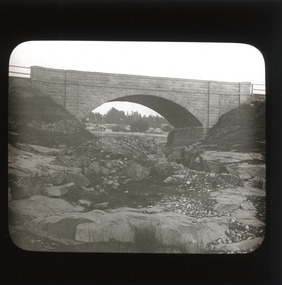 The Beechworth Burke Museum
Photograph - Lantern Slide, c1900
Taken in c.1900 this image shows Newtown Bridge in Beechworth. Newtown Bridge is constructed with granite from the surrounding area and is a great example of the masonry work used in the construction of the town. This bridge has been listed by the National Trust as a significant object to the transportation history of Australia. Lantern slides, sometimes called 'magic lantern' slides, are glass plates on which an image has been secured for the purpose of projection. Glass slides were etched or hand-painted for this purpose from the Eighteenth Century but the process became more popular and accessible to the public with the development of photographic-emulsion slides used with a 'Magic Lantern' device in the mid-Nineteenth Century. Photographic lantern slides comprise a double-negative emulsion layer (forming a positive image) between thin glass plates that are bound together. A number of processes existed to form and bind the emulsion layer to the base plate, including the albumen, wet plate collodion, gelatine dry plate and Woodburytype techniques. Lantern slides and magic lantern technologies are seen as foundational precursors to the development of modern photography and film-making techniquesThis glass slide is significant because it provides insight into Beechworth's social amenities and religious infrastructure in the late Nineteenth Century. It is also an example of an early photographic and film-making technology in use in regional Victoria in the time period.Thin translucent sheet of glass with a square image printed on the front and framed in a black backing. It is held together by metals strips to secure the edges of the slide.burke museum, beechworth, lantern slide, slide, glass slide, plate, burke museum collection, photograph, monochrome, newtown bridge, masonry, transport, bridge, granite -
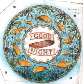 The Beechworth Burke Museum
Photograph - Lantern Slide, c1900
A hand-painted slide from c.1900 depicting a circular image of 11 goldfish swimming around the words 'Good Night'. Lantern slides, sometimes called 'magic lantern' slides, are glass plates on which an image has been secured for the purpose of projection. Glass slides were etched or hand-painted for this purpose from the Eighteenth Century but the process became more popular and accessible to the public with the development of photographic-emulsion slides used with a 'Magic Lantern' device in the mid-Nineteenth Century. Photographic lantern slides comprise a double-negative emulsion layer (forming a positive image) between thin glass plates that are bound together. A number of processes existed to form and bind the emulsion layer to the base plate, including the albumen, wet plate collodion, gelatine dry plate and Woodburytype techniques. Lantern slides and magic lantern technologies are seen as foundational precursors to the development of modern photography and film-making techniquesThis glass slide is significant because it provides insight into early photographic and film-making technology in use in regional Victoria during the late 1800s and early 1900s.Thin translucent sheet of glass with a circular image printed on the front and hand-painted in shades of orange, red, blue, and green.burke museum, beechworth, lantern slide, slide, glass slide, plate, burke museum collection, photograph, monochrome, fish, hand-painted, good night, 1900s -
 The Beechworth Burke Museum
Photograph - Lantern Slide, c1900
This slide depicts an image of elephants from a travelling circus being marched through Camp Street in Beechworth in the early 1900s. Travelling circuses began operation in Australia in the 1860s as a way of providing entertainment to towns across Australia. Many of these traveling circuses use to have exotic animals such as elephants as part of their performances. Lantern slides, sometimes called 'magic lantern' slides, are glass plates on which an image has been secured for the purpose of projection. Glass slides were etched or hand-painted for this purpose from the Eighteenth Century but the process became more popular and accessible to the public with the development of photographic-emulsion slides used with a 'Magic Lantern' device in the mid-Nineteenth Century. Photographic lantern slides comprise a double-negative emulsion layer (forming a positive image) between thin glass plates that are bound together. A number of processes existed to form and bind the emulsion layer to the base plate, including the albumen, wet plate collodion, gelatine dry plate and Woodburytype techniques. Lantern slides and magic lantern technologies are seen as foundational precursors to the development of modern photography and film-making techniques.This glass slide is significant because it provides insight into Beechworth's social amenities and religious infrastructure in the late Nineteenth Century. It is also an example of an early photographic and film-making technology in use in regional Victoria in the time period.Thin translucent sheet of glass with a square image printed on the front and framed in a black backing. It is held together by metals strips to secure the edges of the slide.burke museum, beechworth, lantern slide, slide, glass slide, plate, burke museum collection, photograph, monochrome, circus, travelling circus, elephants, circus elephants, exotic animals, 1900s, entertainment -
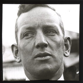 The Beechworth Burke Museum
Photograph - Lantern Slide, c1900
This image of a man is possible an early version of the modern photographic technique the 'selfie'. Lantern slides, sometimes called 'magic lantern' slides, are glass plates on which an image has been secured for the purpose of projection. Glass slides were etched or hand-painted for this purpose from the Eighteenth Century but the process became more popular and accessible to the public with the development of photographic-emulsion slides used with a 'Magic Lantern' device in the mid-Nineteenth Century. Photographic lantern slides comprise a double-negative emulsion layer (forming a positive image) between thin glass plates that are bound together. A number of processes existed to form and bind the emulsion layer to the base plate, including the albumen, wet plate collodion, gelatine dry plate and Woodburytype techniques. Lantern slides and magic lantern technologies are seen as foundational precursors to the development of modern photography and film-making techniques.This glass slide is significant because it provides insight into Beechworth's social amenities and religious infrastructure in the late Nineteenth Century. It is also an example of an early photographic and film-making technology in use in regional Victoria in the time period.Thin translucent sheet of glass with a square image printed on the front and framed in a black backing. It is held together by metals strips to secure the edges of the slide.burke museum, beechworth, lantern slide, slide, glass slide, plate, burke museum collection, photograph, monochrome -
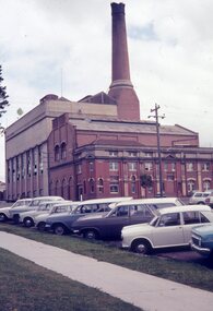 Ballarat Tramway Museum
Photograph - Colour slides - Geelong A Power Station, c1970 and April 1971
... 1 - Green plastic Fuji Film Plastic slide of Photograph... photographs taken June 1970. 2 - Colour slide dated April 1971, taken ...1 - Colour slide of the former Geelong A Power Station on the corner of Yarra St and Corio Tce (now Brougham St). First portion on the corner built by the Electric Lighting and Traction Co of Australia. The Geelong tram depot, operated by the Melbourne Electric Supply Co was incorporated within the structure during 1912. Operated by the State Electricity Commission from 1930 until the 1960's. Photo taken prior to the demolition of the chimney following its sale in June 1970. See item 10002 for other photographs taken June 1970. 2 - Colour slide dated April 1971, taken after the chimney has been demolished. Yields information about the former Geelong A power station prior to its partial demolition and incorporation into a shopping centre. Portions of the original brick buildings have been retained.1 - Green plastic Fuji Film Plastic slide of Photograph of Geelong A Power Station from Yarra St. 2 - Kodachrome cardboard colour slide, date stamped April 1971. No details of Photographer recorded on slide other than the date stamp.geelong, geelong a, power station, mesco, secv, tramways