Showing 1809 items matching "planning and development"
-
 Kew Historical Society Inc
Photograph - Flood at Fairfield Park, 1934
Flooding of the Yarra Valley, including that section of the Yarra bordering Kew and Kew East in the north and west of the municipality, was a regular occurrence. Extreme flood events of the Yarra River are recorded to have occurred in 1891, 1901, 1916, 1923 and 1934. The Municipality of Kew's response to these floods was to enact planning decisions restricting residential development in flood prone areas following the floods of 1916, 1921 and 1934. While floods continued after the development of the Upper Yarra Reservoir (construction 1948-57), the regularity and extent of these inundations diminished.Black and white print positive. Yarra River at Fairfield in 1934. Major flood resulting in submerged buildings in middle ground and onlookers on far bankReverse: "Flood of Yarra at Fairfield Park 1934"fairfield park, yarra valley, river yarra, floods -- 1934 -
 Kew Historical Society Inc
Photograph - Yarra in Flood, 1934
Flooding of the Yarra Valley, including that section of the Yarra bordering Kew and Kew East in the north and west of the municipality, was a regular occurrence. Extreme flood events of the Yarra River are recorded to have occurred in 1891, 1901, 1916, 1923 and 1934. The Municipality of Kew's response to these floods was to enact planning decisions restricting residential development in flood prone areas following the floods of 1916, 1921 and 1934. While floods continued after the development of the Upper Yarra Reservoir (construction 1948-57), the regularity and extent of these inundations diminished.Black and white print positive. 1934 floods of the Yarra Valley. Location Fairfield looking towards wooded hillside. Houses floating in river.Reverse: "From Fairfield Park (11936?) back towards hill (Wurundjeri Spur?)"floods -- 1934, yarra valley, yarra river, fairfield park -
 Kew Historical Society Inc
Photograph - River Yarra in Flood from Kilby Road
Flooding of the Yarra Valley, including that section of the Yarra bordering Kew and Kew East in the north and west of the municipality, was a regular occurrence. Extreme flood events of the Yarra River are recorded to have occurred in 1891, 1901, 1916, 1923 and 1934. The Municipality of Kew's response to these floods was to enact planning decisions restricting residential development in flood prone areas following the floods of 1916, 1921 and 1934. While floods continued after the development of the Upper Yarra Reservoir (construction 1948-57), the regularity and extent of these inundations diminished.Print copy of an original photo of the River Yarra in Flood, taken from Kilby Road.VIEW ACROSS YARRA IN FLOOD / FROM KILBY RD KEWkilby road, floods -- kew (vic.), kilby farm -
 Kew Historical Society Inc
Collection, Floods in North Kew (Series), 1929–1934
Flooding of the Yarra Valley, including that section of the Yarra bordering Kew and Kew East in the north and west of the municipality, was a regular occurrence. Extreme flood events of the Yarra River are recorded to have occurred in 1891, 1901, 1916, 1923 and 1934. The Municipality of Kew's response to these floods was to enact planning decisions restricting residential development in flood prone areas following the floods of 1916, 1921 and 1934. While floods continued after the development of the Upper Yarra Reservoir (construction 1948-57), the regularity and extent of these inundations diminished. Natural disasters had an impact on the development and settlement of Melbourne and its suburbs. Flooding in the Melbourne region was a regular event in the nineteenth and for most of the twentieth centuries. Changes in the impact of natural disasters could occur due to a number of factors. This collection of small snapshots, mostly taken from Kellett Grove in North Kew, provide provenanced evidence of flooding in the area before the development of the unnatural flood barrier that is the Eastern Freeway.Collection of 16 monochrome photographs, annotated on verso by different hands, of the flooding of the River Yarra in North Kew in the third and fourth decades of the twentieth century [1920s & 1930s]. Individual photos include the dates of different floods. Many of the photos were taken from the rear of 8 Kellett Grove; a house still extant in 2023yarra river -- north kew, floods -- yarra valley, floods -- north kew, floods -- 1929, floods -- 1934, natural disasters -- kew -
 Bendigo Historical Society Inc.
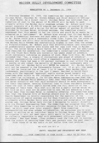
Document - Michele Matthews collection - paperwork and reports for re-zoning of Maiden Gully (1993 - 1996). Residents opposed the re-zoning as they had purchased land as "bush blocks", 25/02/2025
documents for Maiden Gully Sewerage SchemeMichele Matthews collection - paperwork and reports for re-zoning of Maiden Gully (1993 - 1996). Residents opposed the re-zoning as they had purchased land as "bush blocks" Coliban water Annual report 1993/94 21/12/1994 Maiden Gully Development Committee - newsletter No 1 - cttee met with representatives of Coliban Water Caliban Water information Bulletin January 1995 - Maiden Gully Sewerage Scheme 22/02/1995 Maiden Gully Development Committee - newsletter No 2 - cttee activities re the planned sewerage scheme 27/03/1995 - Coliban Water letter to WR & MS Matthews, owners 3 Clay Gully Court (Lot 56 LP 212245) undated - Maiden Gully Neighborhood Sewerage Schemes - Robin Hill Estate Scheme (cost allocation to property owners 21/04/1995 five-page letter of objection/complaint from WR & MS Matthews, owners 3 Clay Gully Court, re costs allocated against their property (Lot 56 LP 212245) 16/06/1995 five-page response from Coliban Water to WR & MS Matthews, owners 3 Clay Gully Court; regarding the outcome of their objection to the sewerage scheme 22/08/1995 letter from WR & MS Matthews, to resident re the results of their objections (and consequent concessions) from Coliban Water re the Robin Hill Estate Sept 1995 Maiden Gully Structure Plan, prepared by TEA planners & Planning Australia Consultants; provides a structure plan, for the Rural City of Marong, the propose future development of the Maiden Gully area Greater Bendigo Planning Scheme - Amendment L43 - Maiden Gully Township: * undated and author unstated - Maiden Gully questions sheet for residents re the proposed Maiden Gully Structure Plan - seven questions and answers * Fauna species - observed /recorded site 6; Maiden Gully (off Pioneer drive) * Explanatory report, three pages * 1/11/1995 Notice of Amendment to a Planning Scheme * Greater Bendigo Planning Scheme, Chapter 6, Amendment L43 (five pages) December 1995 Coliban Water "In the Pipe line", Maiden Gully Region Community Newsletter No 2 - Halfway mark for Sewerage Scheme March 1996 Coliban Water "In the Pipe line", Maiden Gully Region Community Newsletter No 3 - Home stretch for new sewer scheme May 1996 Coliban Water "In the Pipe line", Maiden Gully Region Community Newsletter No 4 - New sewerage scheme comes in well under budget Undated - Maiden Gully Township - Amendment L43 - Panel Hearing report (31 pages) maiden gully, sewerage scheme -
 Falls Creek Historical Society
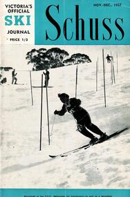
Journal - Schuss Vol. 23. No.8 November - December 1957
Schuss was advertised as Victoria’s Official Ski Journal It was issued monthly from 1935 to 1961 except during the war when summer issues covered two months. This continued after the war, but it averaged 10 issues annually over its 25 year life. Schuss was published by the Ski Club of Victoria which had a membership of 38 Ski Clubs and demanded to be recognised as the prime authority on skiing in the state. The other 30 ski clubs with 85% of the members disagreed and the politics of skiing became heated. These clubs formed the Federation of Victorian Ski Clubs with their own journal, Ski Horizon. With the establishment of the Victorian Ski Association, Ski-Horizon published its last issue in Nov - Dec. 1955 and the role of the official journal was fully taken over by “Schuss”. This item is significant because it contains stories, images and information documenting the development of the ski facilities at Falls Creek.The journal features stories and events chronicling developments in Victoria and internationally. The cover of this issue features a photo by Eric Burt of Nan Dixon, the Victorian Women's Team Captain on the slalom at Buller. Page 255 reveals plans to develop a Community Ski Tow for beginners to be located near Snow Crystal Inn. Page 301 explains the requirement to obtain a permit from the State Electricity Commission and a recommendation to stay at Skyline are the only references to Falls Creek .schuss journal, the ski club of victoria, snow crystal inn, nan dixon -
Whitehorse Historical Society Inc.
Document, 520 Mitcham Road, 1/01/2008 12:00:00 AM
Documents relating to the Planning Permit Application for demolition of an existing dwelling and the development of 52 dwellings at 520-528 Mitcham Road Mitcham, January 2008.Documents relating to the Planning Permit Application for demolition of an existing dwelling and the development of 52 dwellings at 520-528 Mitcham Road Mitcham, January 2008. Contains: VCAT Finding 31 Jan 2008; VCAT Evidence Report by Coomes Consulting Group; Aboricultural statement by Treelogic Pty. Ltd.;Statement of expert design evidence by Hansen Partnership, engaged by the City of Whitehorse; Statement of town planning evidence prep. by Hansen Partnership; Urban design evidence prep. by Message Consultants; Report to VCAT [expert traffic evidence] by Cardno Grogan Richards; Draft conditions by Maddocks, Lawyers for City of Whitehorse; Report, John Patrick Landscape Architects.Documents relating to the Planning Permit Application for demolition of an existing dwelling and the development of 52 dwellings at 520-528 Mitcham Road Mitcham, January 2008. city of whitehorse, town planning, mitcham road, mitcham, no. 520-528 -
 Eltham District Historical Society Inc
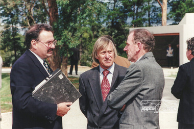
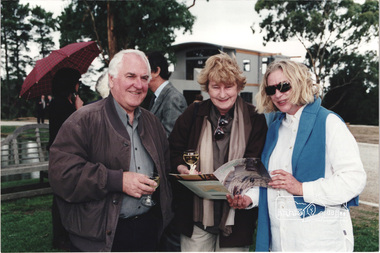
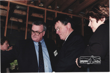
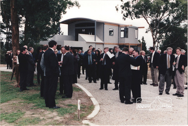
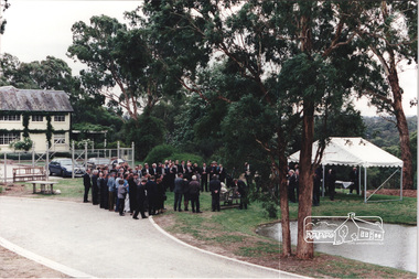
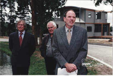
Photograph, Ian Jelbart (right) and Robert Marshall (centre) at the launch of the Kinloch Gardens development, 93 Arthur Street, Eltham, April 1998, April 1998
Launch of the Kinloch Gardens development, 12 new double and triple storey homes along a private road in the gardens of Kinloch, a mansion set on 2.4ha in Arthur St. The launch was attended by Planning Minister Rob Maclellan and Nillumbik Shire president Robert Marshall, Architects Graeme Gunn and Ian Jelbart and approximately 100 guests.8 images; digital file only; created from scan undertaken by EDHS of a set of 26 colour 10 x 15 cm prints arthur street, eltham, graeme gunn, houses, ian jelbart, jelbart property, kinloch gardens, robert marshall, woodridge estate -
 Eltham District Historical Society Inc
Photograph, Architect Graeme Gunn with unknown guests at the launch of the Kinloch Gardens development, 93 Arthur Street, Eltham, April 1998, April 1998
Launch of the Kinloch Gardens development, 12 new double and triple storey homes along a private road in the gardens of Kinloch, a mansion set on 2.4ha in Arthur St. The launch was attended by Planning Minister Rob Maclellan and Nillumbik Shire president Robert Marshall, Architects Graeme Gunn and Ian Jelbart and approximately 100 guests.1 images; digital file only; created from scan undertaken by EDHS of a set of 26 colour 10 x 15 cm prints arthur street, eltham, graeme gunn, houses, ian jelbart, jelbart property, kinloch gardens, robert marshall, woodridge estate -
 Eltham District Historical Society Inc
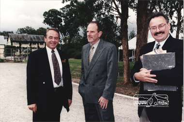
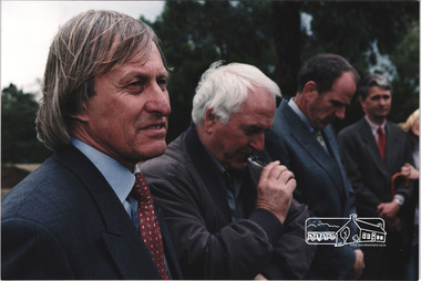
Photograph, Nillumbik Shire President Robert Marshall on left with Architects Ian Jelbart (centre) and Graeme Gunn at the launch of the Kinloch Gardens development, 93 Arthur Street, Eltham, April 1998, April 1998
Launch of the Kinloch Gardens development, 12 new double and triple storey homes along a private road in the gardens of Kinloch, a mansion set on 2.4ha in Arthur St. The launch was attended by Planning Minister Rob Maclellan and Nillumbik Shire president Robert Marshall, Architects Graeme Gunn and Ian Jelbart and approximately 100 guests.4 images; digital file only; created from scan undertaken by EDHS of a set of 26 colour 10 x 15 cm prints arthur street, eltham, graeme gunn, houses, ian jelbart, jelbart property, kinloch gardens, robert marshall, woodridge estate -
 Eltham District Historical Society Inc
Photograph, L-R: Architect Ian Jelbart, Nillumbik Shire President Robert Marshall, Nillumbik Cr. John Graves and Architect Graeme Gunn at the launch of the Kinloch Gardens development, 93 Arthur Street, Eltham, April 1998, April 1998
Launch of the Kinloch Gardens development, 12 new double and triple storey homes along a private road in the gardens of Kinloch, a mansion set on 2.4ha in Arthur St. The launch was attended by Planning Minister Rob Maclellan and Nillumbik Shire president Robert Marshall, Architects Graeme Gunn and Ian Jelbart and approximately 100 guests.3 images; digital file only; created from scan undertaken by EDHS of a set of 26 colour 10 x 15 cm prints arthur street, eltham, graeme gunn, houses, ian jelbart, jelbart property, john graves, kinloch gardens, robert marshall, woodridge estate -
 Eltham District Historical Society Inc
Photograph, L-R: Christine and Ian Jelbart, Robert Marshall, John Graves and Graeme Gunn at the launch of the Kinloch Gardens development, 93 Arthur Street, Eltham, April 1998, April 1998
Launch of the Kinloch Gardens development, 12 new double and triple storey homes along a private road in the gardens of Kinloch, a mansion set on 2.4ha in Arthur St. The launch was attended by Planning Minister Rob Maclellan and Nillumbik Shire president Robert Marshall, Architects Graeme Gunn and Ian Jelbart and approximately 100 guests.8 images; digital file only; created from scan undertaken by EDHS of a set of 26 colour 10 x 15 cm prints arthur street, christine jelbart, eltham, graeme gunn, houses, ian jelbart, jelbart property, john graves, kinloch gardens, robert marshall, woodridge estate -
 Eltham District Historical Society Inc
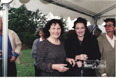
Photograph, Christine Jelbart (left) with two unknown women at the launch of the Kinloch Gardens development, 93 Arthur Street, Eltham, April 1998, April 1998
Launch of the Kinloch Gardens development, 12 new double and triple storey homes along a private road in the gardens of Kinloch, a mansion set on 2.4ha in Arthur St. The launch was attended by Planning Minister Rob Maclellan and Nillumbik Shire president Robert Marshall, Architects Graeme Gunn and Ian Jelbart and approximately 100 guests.1 images; digital file only; created from scan undertaken by EDHS of a set of 26 colour 10 x 15 cm prints arthur street, christine jelbart, eltham, houses, jelbart property, kinloch gardens, woodridge estate -
 Eltham District Historical Society Inc
Photograph, Tom Higginbottom (left) at the launch of the Kinloch Gardens development, 93 Arthur Street, Eltham, April 1998, April 1998
Launch of the Kinloch Gardens development, 12 new double and triple storey homes along a private road in the gardens of Kinloch, a mansion set on 2.4ha in Arthur St. The launch was attended by Planning Minister Rob Maclellan and Nillumbik Shire president Robert Marshall, Architects Graeme Gunn and Ian Jelbart and approximately 100 guests.15 images; digital file only; created from scan undertaken by EDHS of a set of 29 colour 10 x 15 cm prints arthur street, eltham, houses, jelbart property, john graves, kinloch gardens, woodridge estate -
 Eltham District Historical Society Inc
Photograph, In front of the Barn at the launch of the Kinloch Gardens development, 93 Arthur Street, Eltham, April 1998, Cr. John Graves at rear, April 1998
Launch of the Kinloch Gardens development, 12 new double and triple storey homes along a private road in the gardens of Kinloch, a mansion set on 2.4ha in Arthur St. The launch was attended by Planning Minister Rob Maclellan and Nillumbik Shire president Robert Marshall, Architects Graeme Gunn and Ian Jelbart and approximately 100 guests.1 images; digital file only; created from scan undertaken by EDHS of a set of 29 colour 10 x 15 cm prints arthur street, eltham, houses, jelbart property, john graves, kinloch gardens, the barn, woodridge estate -
 Eltham District Historical Society Inc
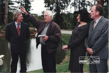
Photograph, Robert Marshall (left) with Jenny and John Graves at the launch of the Kinloch Gardens development, 93 Arthur Street, Eltham, April 1998, April 1998
Launch of the Kinloch Gardens development, 12 new double and triple storey homes along a private road in the gardens of Kinloch, a mansion set on 2.4ha in Arthur St. The launch was attended by Planning Minister Rob Maclellan and Nillumbik Shire president Robert Marshall, Architects Graeme Gunn and Ian Jelbart and approximately 100 guests.2 images; digital file only; created from scan undertaken by EDHS of a set of 29 colour 10 x 15 cm prints arthur street, eltham, houses, jelbart property, jenny graves, john graves, kinloch gardens, robert marshall, woodridge estate -
 Eltham District Historical Society Inc
Photograph, Robert Marshall with Graeme Gunn chatting to John and Jenny Graves (front right) at the launch of the Kinloch Gardens development, 93 Arthur Street, Eltham, April 1998, April 1998
Launch of the Kinloch Gardens development, 12 new double and triple storey homes along a private road in the gardens of Kinloch, a mansion set on 2.4ha in Arthur St. The launch was attended by Planning Minister Rob Maclellan and Nillumbik Shire president Robert Marshall, Architects Graeme Gunn and Ian Jelbart and approximately 100 guests.3 images; digital file only; created from scan undertaken by EDHS of a set of 29 colour 10 x 15 cm prints arthur street, eltham, graeme gunn, houses, jelbart property, jenny graves, john graves, kinloch gardens, robert marshall, woodridge estate -
 Eltham District Historical Society Inc
Photograph, Architect Ian Jelbart (centre) with Elders Real Estate agents at the launch of the Kinloch Gardens development, 93 Arthur Street, Eltham, April 1998, April 1998
Launch of the Kinloch Gardens development, 12 new double and triple storey homes along a private road in the gardens of Kinloch, a mansion set on 2.4ha in Arthur St. The launch was attended by Planning Minister Rob Maclellan and Nillumbik Shire president Robert Marshall, Architects Graeme Gunn and Ian Jelbart and approximately 100 guests.1 images; digital file only; created from scan undertaken by EDHS of a set of 29 colour 10 x 15 cm prints arthur street, elders real estate, eltham, houses, ian jelbart, jelbart property, kinloch gardens, woodridge estate -
 Eltham District Historical Society Inc
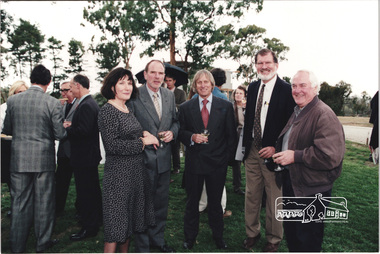
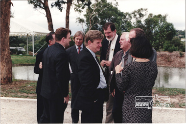
Photograph, L-R: Wayne Phillips, unknown , Robert Marshall, Rob Maclellan, John Graves, Graeme Gunn, Ian and Christine Jelbart at the launch of the Kinloch Gardens development, 93 Arthur Street, Eltham, April 1998, April 1998
Launch of the Kinloch Gardens development, 12 new double and triple storey homes along a private road in the gardens of Kinloch, a mansion set on 2.4ha in Arthur St. The launch was attended by Planning Minister Rob Maclellan and Nillumbik Shire president Robert Marshall, Architects Graeme Gunn and Ian Jelbart and approximately 100 guests.1 images; digital file only; created from scan undertaken by EDHS of a set of 34 colour 10 x 15 cm prints arthur street, christine jelbart, eltham, graeme gunn, houses, ian jelbart, jelbart property, john graves, kinloch gardens, planning minister, rob maclellan, robert marshall, wayne phillips, woodridge estate -
 Eltham District Historical Society Inc
Photograph, Sigmund Jorgensen in centre middle at the launch of the Kinloch Gardens development, 93 Arthur Street, Eltham, April 1998, April 1998
Launch of the Kinloch Gardens development, 12 new double and triple storey homes along a private road in the gardens of Kinloch, a mansion set on 2.4ha in Arthur St. The launch was attended by Planning Minister Rob Maclellan and Nillumbik Shire president Robert Marshall, Architects Graeme Gunn and Ian Jelbart and approximately 100 guests.3 images; digital file only; created from scan undertaken by EDHS of a set of 34 colour 10 x 15 cm prints arthur street, eltham, graeme gunn, houses, ian jelbart, jelbart property, john graves, kinloch gardens, rob maclellan, robert marshall, sigmund jorgensen, wayne phillips, woodridge estate -
 Eltham District Historical Society Inc
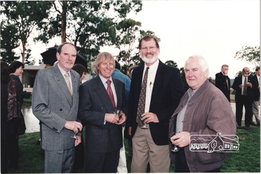
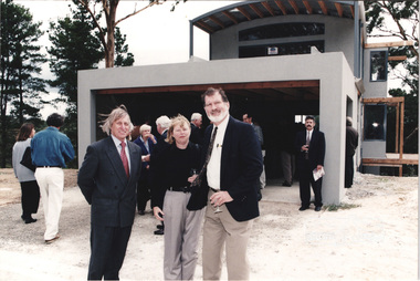
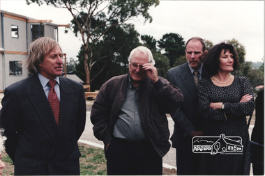
Photograph, Standing L-R: Nillumbik Shire President Robert Marshall, Architect Graeme Gunn and owners Architect Ian Jelbart and his wife, Christine Jelbart at the launch of the Kinloch Gardens development, 93 Arthur Street, Eltham, April 1998, April 1998
Launch of the Kinloch Gardens development, 12 new double and triple storey homes along a private road in the gardens of Kinloch, a mansion set on 2.4ha in Arthur St. The launch was attended by Planning Minister Rob Maclellan and Nillumbik Shire president Robert Marshall, Architects Graeme Gunn and Ian Jelbart and approximately 100 guests.1 images; digital file only; created from scan undertaken by EDHS of a set of 34 colour 10 x 15 cm prints arthur street, christine jelbart, eltham, graeme gunn, houses, ian jelbart, jelbart property, kinloch gardens, robert marshall, woodridge estate -
 Eltham District Historical Society Inc
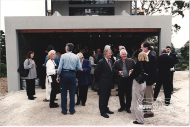
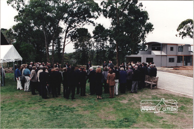
Photograph, At the launch of the Kinloch Gardens development, 93 Arthur Street, Eltham, April 1998, April 1998
Launch of the Kinloch Gardens development, 12 new double and triple storey homes along a private road in the gardens of Kinloch, a mansion set on 2.4ha in Arthur St. The launch was attended by Planning Minister Rob Maclellan and Nillumbik Shire president Robert Marshall, Architects Graeme Gunn and Ian Jelbart and approximately 100 guests.2 images; digital file only; created from scan undertaken by EDHS of a set of 34 colour 10 x 15 cm prints arthur street, eltham, houses, jelbart property, kinloch gardens, woodridge estate -
 Eltham District Historical Society Inc
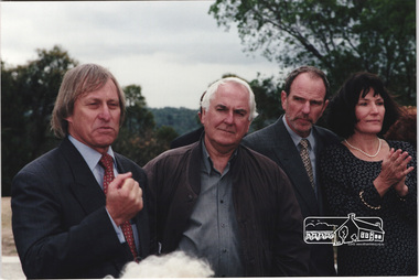
Photograph, Standing L-R: Nillumbik Shire President Robert Marshall, Architect Graeme Gunn and owners Architect Ian Jelbart and his wife, Christine Jelbart at the launch of the Kinloch Gardens development, 93 Arthur Street, Eltham, April 1998, April 1998
Launch of the Kinloch Gardens development, 12 new double and triple storey homes along a private road in the gardens of Kinloch, a mansion set on 2.4ha in Arthur St. The launch was attended by Planning Minister Rob Maclellan and Nillumbik Shire president Robert Marshall, Architects Graeme Gunn and Ian Jelbart and approximately 100 guests.1 images; digital file only; created from scan undertaken by EDHS of a set of 34 colour 10 x 15 cm prints arthur street, christine jelbart, eltham, graeme gunn, houses, ian jelbart, jelbart property, kinloch gardens, robert marshall, woodridge estate -
 Eltham District Historical Society Inc
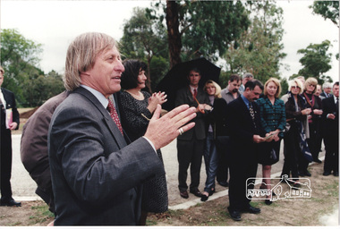
Photograph, Nillumbik Shire President Robert Marshall addressing the guests at the launch of the Kinloch Gardens development, 93 Arthur Street, Eltham, April 1998, April 1998
Launch of the Kinloch Gardens development, 12 new double and triple storey homes along a private road in the gardens of Kinloch, a mansion set on 2.4ha in Arthur St. The launch was attended by Planning Minister Rob Maclellan and Nillumbik Shire president Robert Marshall, Architects Graeme Gunn and Ian Jelbart and approximately 100 guests.4 images; digital file only; created from scan undertaken by EDHS of a set of 34 colour 10 x 15 cm prints arthur street, christine jelbart, eltham, graeme gunn, houses, ian jelbart*, jelbart property, kinloch gardens, rob maclellan*, robert marshall, wayne phillips, woodridge estate -
 Eltham District Historical Society Inc
Photograph, Standing L-R: Nillumbik Shire President Robert Marshall, Architect Graeme Gunn and owners Architect Ian Jelbart and his wife, Christine Jelbart at the launch of the Kinloch Gardens development, 93 Arthur Street, Eltham, April 1998, April 1998
Launch of the Kinloch Gardens development, 12 new double and triple storey homes along a private road in the gardens of Kinloch, a mansion set on 2.4ha in Arthur St. The launch was attended by Planning Minister Rob Maclellan and Nillumbik Shire president Robert Marshall, Architects Graeme Gunn and Ian Jelbart and approximately 100 guests.1 images; digital file only; created from scan undertaken by EDHS of a set of 34 colour 10 x 15 cm prints arthur street, christine jelbart, eltham, graeme gunn, houses, ian jelbart, jelbart property, kinloch gardens, robert marshall, woodridge estate -
 Eltham District Historical Society Inc
Photograph, Standing L-R: Nillumbik Shire President Robert Marshall, Architect Graeme Gunn and owner Architect Ian Jelbart addressing the guests at the launch of the Kinloch Gardens development, 93 Arthur Street, Eltham, April 1998, April 1998
Launch of the Kinloch Gardens development, 12 new double and triple storey homes along a private road in the gardens of Kinloch, a mansion set on 2.4ha in Arthur St. The launch was attended by Planning Minister Rob Maclellan and Nillumbik Shire president Robert Marshall, Architects Graeme Gunn and Ian Jelbart and approximately 100 guests.3 images; digital file only; created from scan undertaken by EDHS of a set of 34 colour 10 x 15 cm prints arthur street, eltham, graeme gunn, houses, ian jelbart, jelbart property, kinloch gardens, robert marshall, woodridge estate -
 Eltham District Historical Society Inc
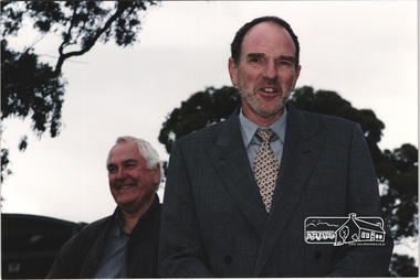
Photograph, Owner and Architect Ian Jelbart addressing the guests at the launch of the Kinloch Gardens development, 93 Arthur Street, Eltham, April 1998, April 1998
Launch of the Kinloch Gardens development, 12 new double and triple storey homes along a private road in the gardens of Kinloch, a mansion set on 2.4ha in Arthur St. The launch was attended by Planning Minister Rob Maclellan and Nillumbik Shire president Robert Marshall, Architects Graeme Gunn and Ian Jelbart and approximately 100 guests.3 images; digital file only; created from scan undertaken by EDHS of a set of 34 colour 10 x 15 cm prints arthur street, eltham, graeme gunn, houses, ian jelbart, jelbart property, kinloch gardens, robert marshall, woodridge estate -
 Eltham District Historical Society Inc
Photograph, Owner and Architect Ian Jelbart addressing the guests at the launch of the Kinloch Gardens development, 93 Arthur Street, Eltham, April 1998, April 1998
Launch of the Kinloch Gardens development, 12 new double and triple storey homes along a private road in the gardens of Kinloch, a mansion set on 2.4ha in Arthur St. The launch was attended by Planning Minister Rob Maclellan and Nillumbik Shire president Robert Marshall, Architects Graeme Gunn and Ian Jelbart and approximately 100 guests.8 images; digital file only; created from scan undertaken by EDHS of a set of 30 colour 10 x 15 cm prints arthur street, eltham, graeme gunn, houses, ian jelbart, jelbart property, jenny graves, john graves, kinloch gardens, robert marshall, woodridge estate -
 Eltham District Historical Society Inc
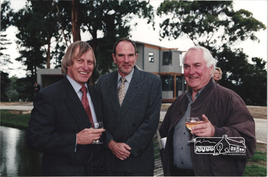
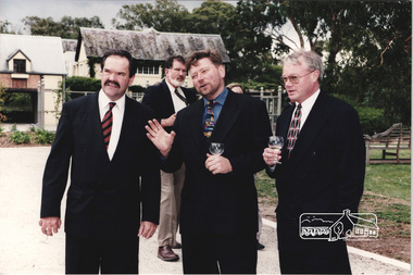
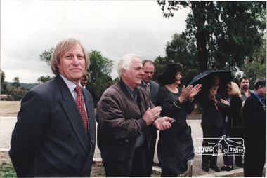
Photograph, L-R: Nillumbik Shire President Robert Marshall with architects Graeme Gunn and Ian Jelbart at the launch of the Kinloch Gardens development, 93 Arthur Street, Eltham, April 1998, April 1998
Launch of the Kinloch Gardens development, 12 new double and triple storey homes along a private road in the gardens of Kinloch, a mansion set on 2.4ha in Arthur St. The launch was attended by Planning Minister Rob Maclellan and Nillumbik Shire president Robert Marshall, Architects Graeme Gunn and Ian Jelbart and approximately 100 guests.3 images; digital file only; created from scan undertaken by EDHS of a set of 30 colour 10 x 15 cm prints arthur street, eltham, graeme gunn, houses, ian jelbart, jelbart property, kinloch gardens, robert marshall, woodridge estate