Showing 2029 items matching "planning document"
-
 Flagstaff Hill Maritime Museum and Village
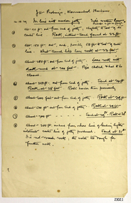
Document - Report, Jet Probings, Warrnambool Harbour, 16-10-1929
This report lists the depths of water and the consistency of the seabed surrounding the Warrnambool Harbour in October 1929, The information, often referred to as 'soundings', was obtained by Jet Probing,. In earlier days a lead line was used to perform a similar task. The author of the document is unknown. Jet Probing is a method used for underwater archaeology, cable installation and coastal engineering. A jet probe is a machine that produces a strong jet of water that penetrates the layers of sediment on the seabed, determining their depth, thickness and consistency. It provides a survey of the seabed and can be used as an aid to engineering design and construction. The report mentions lining up with the wooden jetty, the end of the breakwater and the leading lights. It mentions sand, loose rock and rock. It tells of stopping work due to the water being too rough, the pipe choking, difficulty in connecting pipes, and pipe joint breaking as it tried to get through the sand, The report in the document is significant for its connection with the Warrnambool Harbour, Warrnambool Breakwater, Warrnambool Jetty and Lady Bay. The report gives figures for the depth and consistency of the water and seabed at a particular point in time and can be used to compart with similar figures taken at different times. The results could determine plans for future engineering works.Report, titled 'Jet Probings, Warrnambool Harbour'. Two pages of cream coloured paper with hand written notes in pen and ink. Report covers three days of Jet Probings, with resulting figures and comments, for the depths of the surroundings of the Warrnambool Harbour. The report is in point form, with some underlining. Dates of recordings are 14-10-29, 15-10-29 and 16-10-29. (1929) The situation of the harbour had become a real problem by 1910 and required continuous dredging. In 1914 the Breakwater was extended but proved to be a failure because the work began to subside and by 1920 about two thirds of the harbour was silted up. Alterations made in the 1920's increased the silting problem. The soundings and Jet Probings were done after the Royal Commission of 1923, when the damaged stonework on the seaward side of the Warrnambool Breakwater, caused by the action of the sea, was the subject of enquiry. A conference between the Public Works, Water Commission and the Harbour Trust concluded that it would less costly to make repairs to prevent further damage rather than replaced the damage portion of the wall. A contract was raised in late 1924 to deposit rubble on the damaged side of the breakwater to minimise the Southern Ocean’s destructive action and work had started by August 1925. By the 1940's the harbour was no longer used. More alterations were made in the 1950's and 1960's. document, depth, warrnambool harbour, 1929, soundings, jet probe, jet probing, seabed, map of seabed, underwater engineering, warrnambool jetty, warrnambool breakwater, breakwater upgrade, leading lights, chart the harbour, flagstaff hill, warrnambool, flagstaff hill maritime museum & village, maritime museum, maritime village, shipwreck coast, lady bay, port of warrnambool, breakwater, jetty, pier, vhr h2024, royal commission, 1923, public works, water commission, harbour trust, victorian harbours -
 Flagstaff Hill Maritime Museum and Village
Document
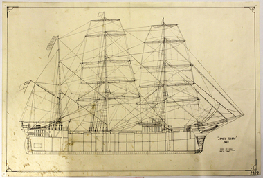
... -museum shipwreck-coast flagstaff-hill-maritime-village Document ...Reproduction of Plans of the James Craig,1903flagstaff hill, warrnambool, shipwrecked-coast, flagstaff-hill, flagstaff-hill-maritime-museum, maritime-museum, shipwreck-coast, flagstaff-hill-maritime-village, document, plans of the james craig, plan -
 Flagstaff Hill Maritime Museum and Village
Document - Plans, Lighthouse Keeper's Quarters Warrnambool, 1858-1909
... Keeper's Quarters Warrnambool Document Plans ...The set of seven 1858 plans shows proposed plans for the original Lighthouse Complex that was built on Middle Island in 1858-1859. The whole complex was then transferred to Flagstaff Hill in 1871. The plan, dated 1909, is for proposed additions and repairs to the Quarters at Flagstaff Hill. The plan 'Alterations and Additions' shows alternate plans for changes to the quarters at the Flagstaff Hill location. This plan has no date. The Complex comprised the Lighthouse, the Lighthouse Keepers’ Quarters, the Store (now called the Chart Room) and a Privy, which was not included in these plans. The Keeper’s bluestone Quarters was a cottage divided into two compartments, one for each keeper and his family. The bluestone Store was divided into three; a store, a workshop an oil store (or office). The Privy comprised of a small building also divided into two separate, back-to-back toilets, one for each Keeper and his family. The Flagstaff Hill Keeper's Quarters have had extensions and additions at various times, and these have also been removed at various other times. THE PLANS - *Dec. 1858 (12/58) ‘Lighthouse Keepers Quarters No.2 Warrnambool’ (2375.01)* Public Works Office Melbourne – Front and Back elevations, sections, and floor plan. The drawing shows timber walls. [The floor plan is the closest plan to the current building, however, the walls are timber in this plan.] *Nov. 1858 – No.3 ‘Lighthouse Keepers Quarters Warrnambool’ (2375.02)* Office of Public Works, Melbourne – Back and End elevations and section through. The drawing shows stone walls. One side; Senior Keeper’s bedroom, living room and kitchen with storeroom. Another side; is the Assistant’s bedroom, living room and storeroom. *Nov. 1858 - No.4 ‘Lighthouse Stores Warrnambool’ (2375.03)* Office of Public Works – Front, Side and end elevations, centre section. The drawing shows stone walls. *Nov. 1858 – No.4, ‘Lighthouse Stores No. 2 Warrnambool’ (2375.04)* Office of Public Works – Front, side and end elevations, centre section. The drawing shows timber walls. *Nov. 1858 – ‘Details Lighthouse Keepers Quarters No. 2 Warrnambool’ (2375.05)* Public Works Office Melbourne. The plan shows the foundations, joists and eaves. The drawing shows timber walls. (Nov. 1858 – ‘No.4 ‘Lighthouse No. 2 – Warrnambool’ (2375.06)* Public Works Melbourne (Part of the paper is missing). This plan shows an octagonal tower, internal stairs, a balcony landing, and a weather vane on top. *November 1858 – No. 1, ‘Lighthouse – Warrnambool’ (2375.07)* Office of Public Works Melbourne. This plan shows a round tower, including the stairs, windows on the tower and the weather vane on the top. *4/3/9 [1909] – ‘Additions and Repairs, Lighthouse Quarters, Warrnambool, General Plan’ (2375.8)* Department of Public Works Melbourne’s official stamp is signed by Croft. It shows the floor plans of the Store, Upper Lighthouse and the Quarters. The Store building has three sections; a Store, Work-Shop and Office, with an internal wall between them and separate entries. The Quarters are divided into two dwellings. The Senior Keeper’s side on the left has fireplaces in two of the three bedrooms and there is a pantry and wash house. The Assistant’s side has no fireplaces in the bedrooms and there’s no pantry or washhouse. These plans include proposed changes to the buildings. The Senior Keeper’s Quarters would have a partition on bedroom 2, a bath with plumbing and drainage, a wall moved and a built-in side porch. The Store would also have a built-in porch. The undated plan 'Additions and Alterations' (2375.9) shows alternative arrangements for water tanks, plumbing and such. WARRNAMBOOL'S LADY BAY LIGHTHOUSES- In the 1800s ships sailing from England to Australia began to use Bass Strait as a faster route to Melbourne. Small navigation errors led to many tragic shipwrecks. From 1848 lighthouses were operating along Victoria’s southern coast as a guide for sailors. Coastal towns such as Warrnambool grew and the exchange of trade and passengers were of great benefit. However, the uncertain weather changes, relatively shallow waters and treacherous, hidden rocky reefs were not suitable for a Harbour and in the 1840s and 1850s there were many shipwrecks in the area, with some even stranded in its Lady Bay harbour. A jetty was built in 1850 and a flagstaff to guide seafarers was placed up high on what became known now as Flagstaff Hill. In November 1857 the Victorian Government recommended that Warrnambool Harbour had beacons and two lighthouses to guide vessels into and out of the Harbour safely. The white light of the Middle Island lighthouse was to be used for the first time on September 1, 1859. The red light of the Beach Lighthouse, a wooden obelisk structure, was first operated on March 25, 1860, but in 1868 this light was ‘discontinued’ due to it being too low. Melbourne’s Department of Public Works decided to relocate the Middle Island Lighthouse Complex - Lighthouse, Keeper’s Quarters, Privy, Store Room and even water tanks - to Flagstaff Hill. The lower obelisk was shortened, and a protruding gallery, railing, and external ladder were added, as well as the light from the Beach Lighthouse. A green guiding light was erected on the end of the jetty. The transfer of the Complex began in March 1871. Each shaped stone of the lighthouse was carefully numbered, removed then reassembled on Flagstaff Hill. In 1872 the well was sunk behind the Lighthouse Keeper’s Cottage. The Keepers and families had left Middle Island in April and moved to Flagstaff Hill in October 1871. Vessels entering Lady Bay align the Upper and Lower Lighthouse towers during the day and the lights at night. The Upper Lighthouse is a round tower, the Lower Light is square. The Lighthouses were categorised as harbour lights rather than coastal lights, so they remain under the control of the Victorian Government’s Ports and Harbours section. The lights were originally powered by oil, then acetylene gas, later by electricity, and then converted to solar power in 1988. In 1993 the solar panel was replaced by a battery charger. A decision was made in 1936 to replace the lighthouses’ lights with unattended lights that no longer required Keepers and Assistants. At least 29 Keepers had attended to the lighthouse from its opening in 1859 to when the last official Lightkeepers left In April 1916. The Warrnambool Harbour Board rented out the Quarters from 1916 to 1936. The Board closed down but the rentals continued with other unknown landlords. In the 1970s the Flagstaff Hill Planning Board was set up under the chairmanship of John Lindsay. The Board was to make recommendations to the Warrnambool City Council regarding the use of the buildings and the rest of the Crown Land on the site. The Flagstaff Hill Maritime Village opened in 1975 and began renovating the Cottage in stages, during which time evidence of a 1920s fire was found in the eastern section of the cottage. Additions of a porch on the west and a washroom on the east were made in the 1980s. The western part of the building is now a Shipwreck Museum and the east has returned to a late 19th-century Lighthouse Keeper’s cottage and includes the screen made by Assistant Lighthouse Keeper Thomas Hope during one of his two periods of service there. THE LIGHTHOUSE KEEPERS Lighthouse Keepers were responsible for keeping their Lighthouse’s lights shining at night. They kept a lookout for passing vessels and changes in weather. They were expected to clean, polish and maintain the equipment and buildings. They kept regular and detailed records of who was on watch, and the time the light was lit, trimmed and extinguished. They kept a journal about other events that occurred. They keep regular, accurate Meteorological Logs. It was expected that they were competent in Morse code signalling. They would be called to help in times of disasters and shipwrecks, and to give official statements about these events. Many Lighthouse Keepers also volunteered as members of the lifeboat crew. The Lady Bay lighthouses were officially classified as small, so the Keepers had the official titles of Senior Assistant Lighthouse Keeper and Assistant Lighthouse Keeper. They were employed by the Public Service and paid rent to live in the Lighthouse Quarters. They were compulsorily retired at the age of 60, with most receiving a superannuation payment. Despite their time-consuming duties, there was time to follow hobbies and crafts such as growing vegetables, playing musical instruments, making models of buildings including lighthouses, and crafting furniture pieces. An example of a keeper’s skills is the carved fire screen made by /assistant Keeper Thomas Hope in the early 20th century and displayed in the Lighthouse Keeper’s cottage at Flagstaff Hill. The last occupants of the Middle Island Complex were Senior Keeper Robert Deverell, his Assistant Keeper, Andrew Farncombe, and their families. They all became the first occupants at the Lady Bay Lighthouse Keepers’ Quarters on Merri Street. The Warrnambool Lighthouse Complex plans are the origin of what is now the Lady Bay Lighthouse Complex. They are a record of the people, process and departments involved in bringing the complex into fruition. The plans are significant to the Complex, which is now listed on the Victorian Heritage Register, H1520, for being of historical, scientific (technological) and architectural significance to the State of Victoria. The Complex is significant as an example of early colonial development. The plan are significant for their connection with the important navigational function of the Lighthouses, a function still being performed to this day. The plans are also significant as an example of a product from the Public Works Department in Victoria in the mid-to-late 19th century. The structures built to these plans still stand strong. Plans for the Lighthouse Complex in Warrnambool, including Lighthouses, Keeper's Quarters and Stores. Seven of the plans are on thin fragile paper, one is on thicker, stronger paper. The drawings have been made in pens coloured red and black. They originate from Public Works in Melbourne. Seven were drawn in 1858, one in 1904, the other is not dated.Dec. 1858 - Lighthouse Keepers Quarters No.2 Warrnambool. Public Works Office Melbourne. Nov. 1858 - No.3 ‘Lighthouse Keepers Quarters Warrnambool. Public Works Office Melbourne. Nov. 1858 - No.4 ‘Lighthouse Stores Warrnambool. Office of Public Works. Nov. 1858 - No.4, ‘Lighthouse Stores No. 2 Warrnambool. Office of Public Works. Nov. 1858 - Details Lighthouse Keepers Quarters No. 2 Warrnambool. Public Works Office Melbourne. Nov. 1858 - No.4 ‘Lighthouse No. 2 – Warrnambool. Public Works Melbourne. Nov. 1858 - No. 1, Lighthouse - Warrnambool. Office of Public Works Melbourne. 4/3/9 [1909] - Additions and Repairs, Lighthouse Quarters, Warrnambool, General Plan. Department of Public Works Melbourne. SIGNED "Croft" "15A" on reverse [no date] - Lighthouse Quarters Warrnambool, Additions and Alterations. "9A" on reverseflagstaff hill, warrnambool, lighthouse keeper's cottage, lighthouse residence, lighthouse, plans, public works, melbourne, flagstaff hill maritime museum, maritime museum, shipwreck coast, flagstaff hill maritime village, chart room, quarters, privy, middle island, beach lighthouse, obelisk, lighthouse keeper, assistant keeper, lighthouse complex, lady bay, lady bay complex, keepers, upper lighthouse, lower lighthouse, ports and harbours, cottage, harbour board, flagstaff hill planning board, meteorological record, robert deverell, andrew farncombe, warrnambool port, warrnambool harbour, residence, alterations, repairs, department of works -
 Federation University Historical Collection
Booklet, University of Ballarat 2009 Draft Strategic Plan Proposals and 2008 Progress Report, 2008, 2008
University of Ballarat later became Federation University Australia. Draft document outlining proposals for the 2009 University Strategic Plan.university of ballarat, strategic plan, vision, dare to be different, motto, charter, david battersby -
 Federation University Historical Collection
Photograph - Photograph and Documents, Anne Beggs Sunter, Latta/Downing Family, Mount Helen
The Federation University Mt Helen Campus was once the farm of John Latta and his wife Elizabeth Ann Dean. The couple married in 1867 and had three children at the time of John Latta's death (Elizabeth Ann b.1870; Mary b.1873; John b.1875). Elizabeth later married George Downing, and had another six children. The house was situated in the vicinity of the current Administration and Caro Conference Centre buildings, surrounded by an orchard, and a well under the current Albert Coates Building (Union Building). The land was purchased by the Ballarat School of Mines for their tertiary division from the Stapleton family.Various items relating to the Federation University Mount Helen Campus, and the early settlers on the land, the Latta Family. .1) Parish Plan, including E. Latta, M. Fiscalini, R. Wynne, R. Nixon, J.U. Smith, J. Davis .2) Part of a 1930s ordinance map showing Ballarat, Buninyong and Greenhill .3) Contour Map with the first two Mt Helen Campus buildings included. .4) Drawing a a proposed campus plan .5) Latta Family negativemount helen campus, latta family, greenhill, e. latta, m. fiscalini, r. wynne, r. nixon, j.u. smith, j. davis, parish plan, john latta, elizabeth latta, george downing, elezabeth downing, green hill, pontresina, abraham baxter, g. dean, market gardens, jim downing, bob thornton, j. hateley, martin fanning, toll keeper, anne beggs sunter -
 Federation University Historical Collection
Document - Report, Ballarat School of Mines and Industries Ballarat Limited 1995 College Plan, 01/1995
... and Industries Ballarat Limited 1995 College Plan Document Report ...Blue covered report stapled at top left corner. Contents include a profile and focus of the School, Training Context, Regional Influences, training priorities, budget summary, organizational structure, corporate goals and objectives, Statement of purpose and key initiatives, Activity Profiles, Performance monitoring, Capital Works Plan. ballarat school of mines, objectives, social and community studies, building studies, rural studies, business studies, vocational arts, hospitality studies, applied science, further education, tafe, technical and further education, ararat campus, ararat prison, langi kal kal prison, ron wild, keith boast, planning services, ross furness, human resources, john kemp, david nicholson, ann mccaggrey, brian webber, martin hill, max palmer, brian mclennan, mary molloy, david flintoff, andrew sullivan, ross holton, hoticulture, bill king, plumbing, les comley, alistair heighway, verity higgins, michael bracher, bob o'shea, derek wren, frank sordello, john ferrier, viginia fenelon, lorraine yeomans, terry o'neil, irene warfe, david manterfield, rocky hazlett, mark bevelander, kevin martin, ian harris, performance monitoring, campus plan -
Federation University Historical Collection
Book - Booklet, University of Ballarat Reconciliation Action Plan, 2009-2010, 2009
Soft covered booklet documenting the University of Ballarat Reconciliation Action Plan. Photographs include Christine Ward, Ben Atkinson, Katrina Beer, Shirley Morganreconciliation action plan, aborigines, aboriginal education unit, ben atkinson, katrina beer, shirley morgan, christine ward, reconciliation, university of ballarat, aboriginal education centre -
 Federation University Historical Collection
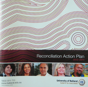
Booklet, University of Ballarat Reconciliation Action Plan, 2012-2014, 2012
This reconciliation Action Plan was published while Bonnie Chew was Manager of the Aboriginal Education Centre.Soft covered booklet documenting the University of Ballarat Reconciliation Action Plan. Photographs include Bonnie Chew, Ben Atkinson, Shanaya Sheridan, Barry Golding, Barbara Webb, Lee Snibsonreconciliation action plan, aborigines, aboriginal education unit, ben atkinson, reconciliation, university of ballarat, bonnie chew, bonnie fagan, shanaya sheridan, national apology, national sorry day committee, naidoc week, reconciliation week, national close the gap day, barry golding, barbara webb, aboriginal education centre -
Glenelg Shire Council Cultural Collection
Plan - Glenelg Shire Council Plan 2004-2008, c. 2004
Glenelg Shire Council Plan 2004-2008. -
Glenelg Shire Council Cultural Collection
Document - Document - Plans machinery, n.d
... photographic copy of plans relating to machinery in 2703 Document ...Port of Portland Authority Archivesport of portland archives -
 Ringwood and District Historical Society
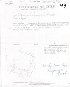
Document, Partial copy of Certificate of Title Vol 7635 Fol 096 Lot 29, 44 Sunbeam Avenue Ringwood East, Victoria
Black and white photocopied page with added notations in blue pen.Ellen Elizabeth Stanton, Married Woman of 35 Bell Street Richmond is now the Proprietor of an estate in Fee-simple, subject to the Encumbrances notified herunder in the surface down to the depth of fifty feet below the surface of the pie of land delineated and colored red purple and blue on the map in the margin, being Lot 29 Parish of Ringwood. Plan of Subdivision No. 12150. (undated). -
 Ringwood and District Historical Society
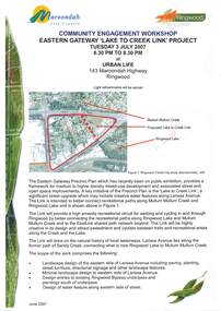
Document - Community Engagement Workshop, Eastern Gateway "Lake To Creek Link" Project - Ringwood, Victoria, 2007
2-page Maroondah City Council notice for workshop on Tuesday 3 July 2007 at Urban Life, 143 Maroondah Highway, Ringwood - light refreshments served.A key initiative of the Precinct Plan is the significant street upgrade which may include creative water features along Larissa Avenue to better connect recreational paths along Mullum Mullum Creek and Ringwood Lake. -
 Ringwood and District Historical Society
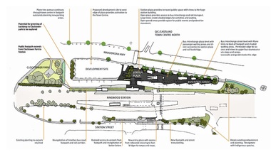
Document, Ringwood Transit City Public Domain and Landscape Guidelines (Railway Precinct, Ringwood, Victoria) 2012
4-page Urban Planning/Urban Design/Landscape Architecture guidelines for the design of street furniture, paving treatments and signage elements throughout the railway station precinct.Department of Transport. Aurecon & Grimshaw Architects. -
 Ringwood and District Historical Society
Document, Transfer of Land Act - 123 Canterbury Road, Heathmont, Victoria
Photocopied Certificate of Title Vol 8446 Fol 751 dated 27th May, 1963. Valfrids Teodors Celms of 123 Canterbury Road Heathmont, Hardware Retailer, is now the proprietor, Lot One on Plan of Subdivision No.36857, Parish of Ringwood. Page 2/3 - Transfers - Ansis Rudolf Kilevics and Mirdza Erika Kilevics, registered as joint proprietors 27th May, 1963. Mirdza Erika Kilevics registered as surviving proprietor 9th November, 1966. Velfrid Teodors Celms registered as proprietor 18th November, 1966. John Boer and Brenda Marion Boer registered as joint proprietors 11th July, 1973. Page 4/5 - Photocopy of Certificate of Title Vol 9557 Fol 423 dated 31 May, 1984 shows John Boer and Brenda Marion Boer mortgate discharged 31 October, 1984. -
 Ringwood and District Historical Society
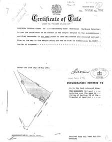
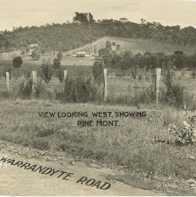
Document - Property Titles, Transfer of Land Act - "Pinemont", Ringwood, Victoria
Folder containing copies of LANDATA documents relating to "Pinemont", Panorama Avenue, Ringwood, Victoria, compiled for potential real estate sales background information purposes. Title Vol 965 Fol 923 Allotment 27B Parish of Warrandyte - James Forbes, dated 30th August, 1876. Title Vol 5236 Fol 1947157 Lots 294 and 370 on Plan of Subdivision no.11392 - Anthony Loughnan, dated 4th March, 1927. Title Vol 6415 Fol 1282937 Lot 294 on Plan of Subdivision no.11392 - Jessie McCracken Rothwell Woodard, dated 9th September, 1940. -
 Ringwood and District Historical Society
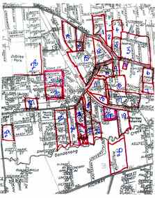
Document, Collection of copies of Maps relating to Wieland Houses and Properties (most undated), plus Document entitle Brian Pump's Orchard and House Locations, 25/2/2008
Collection of A4 photocopies of maps and plans, some with yellow highlighting, showing locations of Wieland properties and house including sub-divisions. Mostly in Heathmont but also Scoresby Most pages are undated and do not have original sources Document 28054 entitled Brian Pump's Orchard and House Locations has notes with maps of various houses with numbers corresponding to those on the included maps and also to those in 28054-003 document -
 Ringwood and District Historical Society
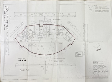
Document, Ringwood Bowls Club- Architects floor plan of proposed new clubrooms, 1997
Copy of floor plan of new clubrooms.Fully dimensioned floor plan. Architects: Sheppard & Dwyer Pty Ltd, Richmond. -
 Ringwood and District Historical Society
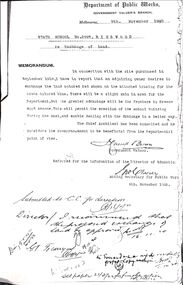
Document, Ringwood State School - Exchange of Land along Greenwood Avenue, 1920
... , dated 9th November, 1920. Document 2, Plan of Exchange of Land... at Ringwood School, dated 9th November, 1920. Document 2, Plan ...Photocopy of 2 documents.Document 1, Memorandum from the Government Valuer, Department of Public Works re Exchange of Land at Ringwood School, dated 9th November, 1920. Document 2, Plan of Exchange of Land in Greenwood Avenue, 1920. -
 Bendigo Historical Society Inc.
Document - H.A. & S.R. WILKINSON COLLECTION: CONTRACT OF SALE
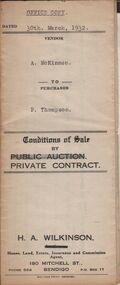
Conditions of sale by private contract dated 30th March, 1932 between A. McKinnon (seller) and P. Thompson (buyer) for land situate in Murphy Street, Bendigo being the balance of the subdivision unsold of Crown allotment 151,270A, 271A, 271C, 271R, 195, 196, 270C, 271B and 271D described in certificate of title volume 2666 folio 533101, and being the land at present occupied by the vendor, not including the allotments or read showed on plan of subdivision. Together with weatherboard dwelling and all sundry including galvanized iron tank and stand, water trough and loose timber in paddock but does not include any window or verandah blinds. Price 800 pounds.organization, business, h.a. & s.r wilkinson real estate -
 Bendigo Historical Society Inc.
Document - H.A. & S.R. WILKINSON COLLECTION: CONTRACT OF SALE
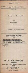
Conditions of sale by private contract dated 19th October, 1933 between Mrs. P.I. Clark (seller) and Miss M. Thompson (buyer) for land situate McIvor Road, Bendigo being lots 2,5 and 6 on plan of subdivision No. 13539 and being Crown allotment 196 and parts of Crown allotments 151,195 and 270A section H described in certificate of title volume 5756 folio 1151098, together with all fences and erections thereon. Price 150 pounds.organization, business, h.a. & s.r wilkinson real estate -
 Bendigo Historical Society Inc.
Document - H.A. & S.R. WILKINSON COLLECTION: CONTRACT OF SALE
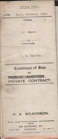
Conditions of sale by private contract dated 21st. October, 1935 between J. Mahon (seller) and H. Taylor (buyer) for land situate Hodgkinson Street, Bendigo having a frontage of approx. 52 feet by a depth of approx. 108 feet, being parts of lots 6 and 7 on plan of subdivision registered No.13862 part of Crown allotments 6 and 7 section 38C land described in Crown grant volume 1502 folio 300225 and Crown grant volume 2642 folio 528242. Price 50 pounds. Attached receipt and plans to build house on that land (W. H. Ellis builder) for 500 pounds also attached detailed list of materials and labour.organization, business, h.a. & s.r wilkinson real estate -
 Bendigo Historical Society Inc.
Document - HANRO COLLECTION: PLANS AND REPORT FROM FIRE ENGINEERS AND SURVEYORS, 1954/1960
... areas. Box 116A Document HANRO COLLECTION: PLANS AND REPORT FROM ...Plans and Report from Fire Engineers and Surveyors:- Green Card has a rectangular box with an ornate border in the centre of the front page. Inside the border is typed in black *Plans, Hanro (Aust) Knitting Mills Limited, Bendigo Victoria Australia. At the bottom:- Mahlstedt's (Vic) Pty Ltd. (est. 1884). Consulting Fire Engineers and Surveyors. Temple Court, 422 Collins Street., Melbourne C.1. Telephone 673069. Inside the folder is the Key to Detail Block Plans & Fire Surveys. Correspondence from Mahlstedt's Pty Ltd to Edward Lumley and Sons, Insurance Brokers regarding a new survey and the changes to the building with respect to fire hazard. Main report recommendations and general information on the building. Blue print of Shirt Factory, Inglewood Road No. 1061 by Welmar Ltd Bendigo. Small blue print of the main buildings showing different work areas. Blue print No.1119 of John Brown Industries Ltd Alley Street Bendigo showing work areas. Box 116AMahlstedt's (Vic) Pty Ltdhanro, clothing, plans and reports, edward lumley & sons pty ltd. hanro knitting mills. mahlstedt's (vic) pty ltd. welmar ltd bendigo. john brown industries ltd. -
 Bendigo Historical Society Inc.
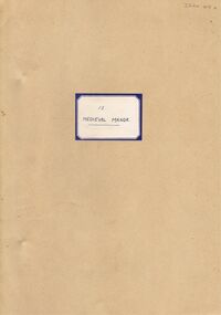
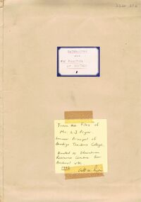
Document - LA TROBE UNIVERSITY BENDIGO COLLECTION: MEDIEVAL MANOR 13
A brown paper folder titled "Medieval Manor". A teaching plan to teach life in 'Medieval England'. From the files of Mr. L.J. Pryor. Former Principal of Bendigo Teachers' College. Donated to Education Resource Centre for archival use in 1992.bendigo, education, bendigo teachers' college, la trobe university bendigo collection, collection, bendigo, bendigo teachers' college, history, history - study and teaching, curriculum, mr. l.j. pryor, male, person, individual, education, education resource centre -
 Bendigo Historical Society Inc.
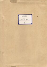
Document - LA TROBE UNIVERSITY BENDIGO COLLECTION: BOOKS AND ASSIGNMENTS 9
A brown paper folder titled "Books and Assignments 9". From the files of Mr. L.J. Pryor. Former Principal of Bendigo Teachers' College. Donated to Education Resource Centre for archival use in 1992. A separate brown envelope sent to Mr. L.J. Pryor in 1945 contains a "Sample set of Assignments for a History Topic for Grades V-VI in the Rural School". The envelope also contains some hand made teaching cards containing lesson plans titled 'The New Learning. A separate envelope contains photos of historical figures to be used as teaching aids.bendigo, education, bendigo teachers' college, la trobe university bendigo collection, collection, bendigo, bendigo teachers' college, education, history - study and teaching, history, mr. l.j. pryor, person, male, individual, teaching, curriculum, education resource centre -
 Bendigo Historical Society Inc.
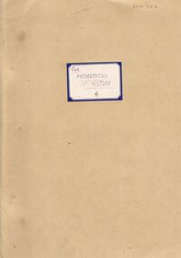
Document - LA TROBE UNIVERSITY BENDIGO COLLECTION: THE PRESENTATION OF HISTORY 4
A brown folder titled "The Presentation of History 4". A teaching plan with which to teach the curriculum subject history. From the files of Mr. L.J. Pryor. Former Principal of Bendigo Teachers' College. Donated to Education Resource Centre for archival use 1992.bendigo, education, bendigo teachers' college, la trobe university bendigo collection, collection, bendigo, education, history, history - study and teaching, teaching, curriculum, stdents, mr. l.j. pryor, male, individual, person, education, resource centre -
 Bendigo Historical Society Inc.
Document - LA TROBE UNIVERSITY BENDIGO COLLECTION: THE HISTORY CURRICULUM 3
A brown folder titled "The History Curriculum 3". A teaching plan with which to teach the currculum subject history. From the files of Mr. L.J. Pryor. Former Principal of Bendigo Teachers' College. Donated to Education Resource Centre for archival use in 1992.bendigo, education, bendigo teachers' college, la trobe university bendigo collection, collection, bendigo teachers' college, bendigo, education, teaching, history, history - study and teaching, curriculum, mr. l.j. pryor, male, person, individual, education resource centre -
 Bendigo Historical Society Inc.
Document - LA TROBE UNIVERSITY BENDIGO COLLECTION: THE VALUE OF HISTORY 2
A brown folder titled "The Value of History 2". A teaching plan with which to teach the contribution of history to students. From the files of Mr. L.J. Pryor former Principal of Bendigo Teachers' College. Donated to Education resource Centre for archival use in 1992. Also included is a small booklet titled "Record of Lessons" with the name Fred East Past Lecturer, Bendigo Teachers' College.bendigo, education, bendigo teachers' college, la trobe university bendigo collection, collection, bendigo, bendigo teachers' college, teaching, teachers, history, history - study and teaching, mr. l.j. pryor, male, individual, person, education resource centre, curriculum -
 Bendigo Historical Society Inc.
Document - LA TROBE UNIVERSITY BENDIGO COLLECTION: INTRODUCTORY AND FUNCTION OF HISTORY
A brown manilla folder titled "Introductory and The Function of History 1". A teaching plan with which to teach the curriculum subject History. From the files of Mr. L.J. Pryor, former Principal of Bendigo Teachers' College. Donated to the Education Resource Centre for Archival use in 1992 by Mr. Geoff W. Pryor.bendigo, education, bendigo teachers' college, la trobe university bendigo collection, collection, bendigo, education, teaching, students, history, history - study and teaching, mr. l.j. pryor, male, person, individual, bendigo teachers' college, education resource centre, curriculum -
 Bendigo Historical Society Inc.
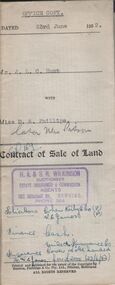
Document - H.A. & S.R. WILKINSON COLLECTION: CONDITION OF SALE
Contract of sale of land dated 23rd June, 1952 between Mr. J.L.C. Hunt (seller) and Miss D.A. Phillips for land being Lot 18 on plan of subdivision No. 14194, being part of Crown allotments 454A and 476 section H described in certificate of title volume 6110, folio 975 situate in Murray Street, Bendigo, together with 50roomed weatherboard dwelling and all sundry. Price 2,525 pounds.organization, business, h.a. & s.r wilkinson real estate -
 Bendigo Historical Society Inc.
Document - H.A. & S.R. WILKINSON COLLECTION: CONDITION OF SALE
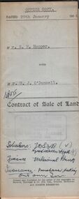
Contract of sale of land dated 29th January 1954 between Mr. E.M. Hopper (seller) and Mr. G.J. O'Donnell (buyer) for land being Lot 2 on plan of subdivision No. 23332 registered in the office of titles, Melbourne and situate in Lindsay Street Kangaroo Flat part of Crown allotment 11 section 23, township of Kangaroo Falt described in Certificate of title volume 7446 folio 423, together with weatherboard dwelling, wood shed-lavatory also fencing on the said land. Price 2,700 pounds.organization, business, h.a. & s.r wilkinson real estate