Showing 694 items
matching reef mining
-
 Tarnagulla History Archive
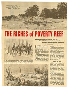
Magazine clipping: 'The Riches of Poverty Reef', The Riches of Poverty Reef, 1964
Donald Clark Collection. Clipping from People magazine of July 15, 1964. Article titled 'The Riches of Poverty Reef'. Pertains to the founding story of Poverty Reef Mine, the origin of its name, founder David Hatt and the shipwreck from which he was saved 'by a Maori princess' whom he later married. Also covers bushranging and log lockups. Original, not copy.tarnagulla, poverty mine, gold, mining, david hatt, margaret hatt, captain melville, carisbrook -
 Tarnagulla History Archive
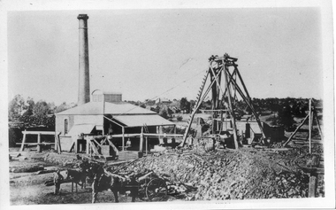
Photograph, Victoria Shaft on Poverty Reef, Tarnagulla, June 1866
Donald Clark Collection. A monochrome photograph depicting a mine with poppet head at Tarnagulla Copy photograph. mining -
 Tarnagulla History Archive
Newspaper article - A Promise Of A Golden Rebirth Rekindles Fire And Hope In The Aging Heartbeat Of The Old Tarnagulla, A Promise Of A Golden Rebirth Rekindles Fire And Hope In The Aging Heartbeat Of The Old Tarnagulla, June 4,1988
Don Clark Collection. An article (across two clippings) from the Bendigo Advertiser newspaper of June 4,1988 titled 'A Promise Of A Golden Rebirth Rekindles Fire And Hope In The Aging Heartbeat Of The Old Tarnagulla'. Discusses Western Mining returning to mine Poverty Reef and hopes it will revitalise the town of Tarnagulla. Images of Les Williams, John Lavery, Chris Williams, Don Shipston and Bill Goltz. tarnagulla, mining, western mining, revitalization, people, golden age hotel, lochcarron -
 Wodonga & District Historical Society Inc
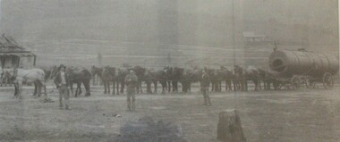
Photograph - North-Eastern Gold Days, 1900
Bethanga was established as a result of the discovery of gold. Gold was first reported in the Bethanga area in 1852. Before 1876 gold mining in the Bethanga district occurred to the north of the town and was known as the 'Talgarno diggings'. Reports of alluvial gold date back to 1852. Early gold fields were worked at Ruby Creek, Gold Creek and Jarvis Creek. The opening of the Bethanga goldfields began with the discovery of a gold-bearing quartz reef on New Year’s Day 1876. The 'Gift' mine site is located southeast of Kurrajong Gap lookout to the west of Bethanga township. The Great Eastern Copper Smelting Works was opened in 1878. Due to the nature of the gold-bearing quartz reef, the gold was difficult to extract, and the discovery of copper led to a change in focus. It was not until the early 1890s that an efficient technique for extracting the gold from the ore was discovered, and once again gold became the focus, with copper as a by-product. Bethanga was removed from the official list of goldfields in 1912, however some mining activity has taken place since.This image reflects an important time in the development of Bethanga and Northeast Victoria.A large mounted and framed image of horse teams and their owners hauling a large boiler to the gold mine near Bethanga, Victoria. On label beneath image: "North-eastern "Gold Days"/ Combined teams hauling a boiler to Bethanga Mines, 1900. Teamsters - Mr. G. Pearce, W. Chapple, G, Bannon." Donated by Ron Saunders and Barbara Cadman"bethanga, gold mining northeast victoria, gold mining bethanga, bethanga history -
 Wodonga & District Historical Society Inc
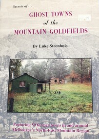
Book - Secrets of Ghost Towns of the Mountain Goldfields, Luke Steenhuis, 1999
Stories from 50 former towns in and around Melbourne's North-east mountain region. These old towns include: Aberfeldy, Aberfeldy Crossing, BB Township, Blue Jacket, Clarke's Flat, Concord Gully, Edwards Reef, Fultons Creek, Jericho, Loch Fyne, Red Jacket, Store Point, The Springs, Toombon, Toombon Upper, Tullamore, Upper Thomson, Victors Quartz, Violet Town & White Star.non-fictionStories from 50 former towns in and around Melbourne's North-east mountain region. These old towns include: Aberfeldy, Aberfeldy Crossing, BB Township, Blue Jacket, Clarke's Flat, Concord Gully, Edwards Reef, Fultons Creek, Jericho, Loch Fyne, Red Jacket, Store Point, The Springs, Toombon, Toombon Upper, Tullamore, Upper Thomson, Victors Quartz, Violet Town & White Star.ghost towns victoria, gold mining victoria -
 Bendigo Historical Society Inc.
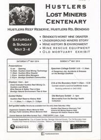
Document - GREAT EXTENDED HUSTLERS GOLD MINE: LOST MINERS FLYER FOR CENTENARY OF MINE DISASTER
On May 2nd 1914, 7 miners were killed in a dynamite explosion in the Great Extended Hustler's Gold Mine. It was Bendigo's worst mining disaster and although an inquest found it was an accident, no cause for the explosion was found.Advertising flyer for an event held on May 3-4 2014, to mark the centenary of the mine disaster that killed 7 minersat the Great Extended Hustlers mine. Other activities included a Specimen Cottage exhibit; guided walks around the Hustlers Reef Reserve; displays on site and talks by various speakers on the mine disaster and mining technology. Event was organised by the Bendigo Historical Society in conjunction with the Hustlers Reserve committee. -
Bendigo Historical Society Inc.
Document - CENTRAL DEBORAH GOLD MINE: ADDITIONAL MINES ALONG THE DEBORAH LINE OF REEF
BHS CollectionA4 yellow paper. List of additional mines along the Deborah reef. Walter Scott, Tadmor, Rose of England, Herschel and Tait, Vital, Metropolitan, Metropolitan South shaft, Monument Hill Central, Monument Hill old, Violet. Locations of each mine listed with name.bendigo, mining, central deborah gold mine, central deborah gold mine -
Bendigo Historical Society Inc.
Document - CENTRAL DEBORAH GOLD MINE: MINES ALONG THE DEBORAH ANTICLINE
BHS CollectionPlan of reef line showing the location of the Deborah Gold Mines. Drawn by Philip Wilkin for the 60th anniversary of the closing of the Central Deborah Gold Mine.bendigo, mining, deborah gold mines, deborah gold mines -
 Bendigo Historical Society Inc.
Administrative record - Spring Gully Gold Mining Co. Fryerstown, Minute Book1903 - 1915, 1924 - 1929
The Spring Gully Gold Mining property consists of Gold Mining Lease No. 2986, Castlemaine, of about 21 acres situated on the Emu Reef, in Spring Gully Fryers. There are two shafts, distant about 300 feet from each other. From one of them large quantities of gold were obtained in former years by previous companies. ( Prospectus of the Spring Gully Mining CompanyMaroon hard cover book, brown leather binding on spine and corners, three hundred and eighty pages. Written on spine of book in gold leaf : 'Minute Book'. Handwritten minute entries from 14th September 1903 to 30th August 1915. Affixed to first page, newspaper clipping from the 'Herald' 13/9/05, with information about the Spring Gully Mine Fryerstown. Page eighty-one has two quotes affixed from 'The Yarraville Chlorination and Ore Reduction Works' High Street Yarraville, July 1905, for works associated with pyrites and blanket sand. Page nine, a handwritten letter affixed to minutes, applying for a block of land 250 feet north of main shaft. Signed by J.S. Potter, H. Hancock, G Murray and T. Tumney. 1.Page one hundred and one: three quotes from 'Edwards' Metallurgical Works' Specimen Hill, Bendigo for pyrites and blanket sand. 2.Page one hundred and fifty five: handwritten letter (copy) from A. Schonfelder re shaft work on the mine and mention of tributors 3. Affixed to inside cover: letter from the 'United Shire of Mount Alexander' April 15th. 1907, regarding the reconstruction of the Vaughan bridge over the Loddon River. 'the benefit that the mines in your district derive from the bridge being open for wood waggons and this being the main traffic and this being the principal cause of the bridges present condition'. 4. Prospectus of the Spring Gully Mining Company, Spring Gull, Fryerstown, two page folded document enclosed inside back cover of book. Prospectus incomplete. (10746.93a) 5. Carbon copy of letter to D.E. Williams Esq, Castlemaine from GlenAthol, Casewick Road, London, January 25th, 1907 regarding two gentlemen who were 'called upon to carry the 'Spring Gullys' through - Mr. H. 'is making a determined effort to bring the matter to a successful issue' Letter signed by George Allan. (10746.93b. 6. Carbon copy of letter from E. Williams, London re proposed new company to acquire the properties of Spring G.M. Coy, Spring Gully G.M. Coy. No. 1, Sth Spring Gully G.M. Coy, Sth Spring Gully G.M. Coy Extended (10746.93c) 7. Handwritten letter to the Chairman and Directors of the Spring Gully G.M. Co. re the appointment of 'Mr. Samuel Morse Battery Manager at once, or accept my resignation as Mining Manager, for we can't agree any longer' Signed by A. Schonfelder. 8. Notice of extraordinary meeting of shareholders in Spring Gully Gold Mining Company No Liability, 22nd November 1906 at Beehive Chambers, Bendigo. Signed W.G. Blackham (Blackham & Garvin) Manager of the Company. (10746.93e) The Minute Book is part of the Margaret Roberts Collection of mining documents.bendigo, margaret roberts, , goldmining, castlemaine, spring gully gold mine, fryertown -
 Tarnagulla History Archive
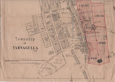
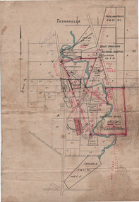
Linen-Backed Map of Tarnagulla Dated 1860 with Updates, Including Mining Leases
This is a very nice linen-backed map first published in 1860 and progressively updated, the latest being 1924 at the time of Government boring on the Poverty Reef. The map clarifies details of the mining leases as they stood in 1924, and the map also identifies previously uncertain details such as the location of the battery well, and also the location of the 1909 syndicate to the south of the Sandy Creek Co's shaft. The lightly pencilled location of the Birthday shaft is incorrect. This mine was located further to the east. -
 Bendigo Historical Society Inc.
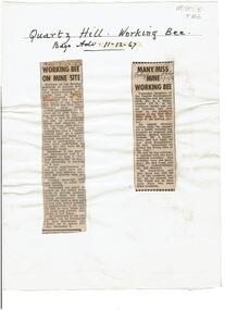
Newspaper - Quartz Hill Working Bee, 1967
Quartz Hill is situated on the Sheephead line of reef and is situated just south of where the Red, White and Blue Consolidated Gold Mine operated. Two newspaper cuttings affixed to lemon backing sheet. Written on top in black pen: 'Quartz Hill Working Bee, Bdgo Adv. 11.12.67' Cutting one, 'Working Bee on Mine Site' with 7.12.67 written across the top, describes an appeal to get volunteers to clear the site of former mines on Quartz Hill. This is anticipated to 'clear the site of accumulated debris and clean out the two large adits driven into the hill and thus make the site a 'tourist visiting spot'. Cutting two, 'Many Miss Mine Working Bee' dated 11.12.67, describes the poor response to the working bee. ' Members of the Tourist Development Association and the Town Clerk, Mr. A.J. Watts, cleared 175 feet of the Northern tunnel and cut an entrance way and steps in the Southern tunnel of the New Blue Mine area in the first stage of the mining project. Mr. J. Stanistreet said last night he was most disappointed. He said: 'apparently we picked the wrong time of the year'.mining, sandhurst, new blue consolidated gold mine, red white and blue consolidated gold mine, quartz hill, sheepshead reef line, a.j. watts, j. stanistreet, bob long -
 Warrnambool and District Historical Society Inc.
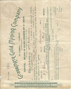
Document, Share Certificate
Grassmere is a small hamlet about 12 kilometres from Warrnambool. It is a farming area. The Grassmere Gold Mining Company, presumably established by local people in Grassmere, was created in 1898 for the purpose of acquiring from Messrs James and Mewha a lease of a Cassilis gold mine (23 acres). £5000 was to be raised in shares of five shillings and one shilling each. The Manager of the Company was Horatio Dickson of Melbourne and the brokers were McMeekin and Co. of Melbourne and Warrnambool and Dickson and Osborne of Melbourne. This reef mine was one of several in Cassilis, Gippsland, 12 kilometres north west of Swifts Creek. The gold-bearing quartz reefs were discovered in 1885 and worked to 1914. It is not known whether the Grassmere Cassilis mine was a financial success but the mining operations were impeded by the hardness of the stone in the area. William Robinson was a farmer in the Grassmere district. This certificate is of considerable interest as one of only three items the Warrnambool and District Historical Society has that is connected with the establishment of the Grassmere Gold Mining Company. The gold mine establishment was one of the many minor events in the district in the 1890s. This is a small buff-coloured certificate detailing the shares of William Robinson in the Grassmere Gold Mining Company (1898). The certificate has green printing and black-ink handwriting. The bottom section (Form of Transfer) is not filled in. There is a stamp of the Grassmere Gold Mining Company with the words ‘No Liability’. There is a decorative pattern in green on the left margin with the address of the company and the name of the printer. ‘This is to certify that Wm. Robinson of Grassmere is a member of the above-named company and the proprietor of fifty (50) shares, numbering 12651/12700 therein, upon which the sum of one shilling has been paid up, subject to the Rules and Regulations of the Company. Dated this 15th day of September, 1898. W.J. Roland, Director, .H. (es) Dickson, Manager.’grassmere, grassmere gold mining company, william robinson, warrnambool -
Bendigo Historical Society Inc.
Document - MINING IN BENDIGO COLLECTION: NAMES OF MINING SLIDES
BHS CollectionTyped copy and two handwritten copies of index to mining slides per Bob Aulsbrook, 30.12.69 and Ian Hendry.document, gold, mining in bendigo, mining in bendigo, names of mining slides, bob aulsbrook, ian hendry, new chum railway, healthy golden bendigo, lansells 222, lansell's fortuna, old chum mine, from new chum hill, to victoria hill, plan of leases on victoria hill 1859, lansell's big 180, bendigo & vicinity, victoria quartz, wm rae's crushing machine, hercules & energetic, mungo mines, united devonshire, mungo group & devonshire mines 1888, catherine reef united, garden gully united, knipe;s castle, old carlisle, nth garden & passby, koch's pioneer quartz crushing battery, great northern mine, virginia mine, specimen hill, new argus, south new moon, new moon, big blue mine, eadie's whim & central blue mine, fortuna hustlers, pictorial photos of victorian views, hustler's royal reserve mine - city, extended hustler's freehold - looking south, great extended hustlers, hustlers reef mine, central nell gwynne, cornish boiler, lancashire boiler, wannan's e'drivers guide, winding engine - new moon, 20 drill air compressor - new moon 1904, engine at virginia crushing battery, lansell's 105 head crushing battery, deeble's pyrites works, miner at central deborah, level at 1045 feet at new moon, boring on a reef at catherine reef, deborah mine 1000 ft level, mines dep't melb & bendigo, engine beds lansell's big 180, new hustlers, rae's open cut, ballerstedt's first open cut, 3 of early days of bendigo, geo lansell -
 Bendigo Historical Society Inc.
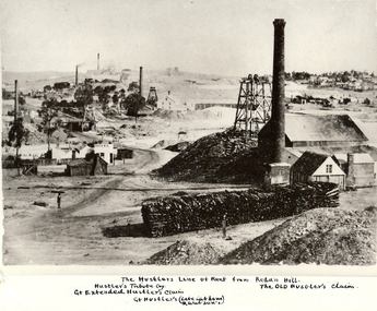
Photograph - HUSTLER'S LINE OF REEF
BHS CollectionBlack and white photograph of mining landscape with poppet head, chimney and mining sheds (plus timber in stack) in foreground. Other mines in bare landscape on LHS background and housing on RHS background. Inscriptions: on front - 'The Hustler's Line of Reef from Redan Hill Hustler's Tribute Coy', 'Gt. Extended Hustler;s Claim', 'The Old Hustler's Claim, Gt. Hustlers (Late Latham & Watson's). On back - 'A Richardson, 29 Harrison Street, Bendigo'.mine, gold, hustlers reef mine, bendigo, mines and mining, mine, mines, mining, landscape, mining landscape, redan hill, poppet head, old hustlers, mining cottages -
 Tarnagulla History Archive
Linen-Backed Map of Poseidon Goldfield, c1915, with Mining Leases and Shaft locations
This is a very nice foolscap-size map, probably prepared by a Mines Department or other Government surveyor with the intention of assisting to attract mining capital to the goldfield. The red sketched-in deep lead positions are inaccurate. The pencil notation upper left reads "Lowther's Lease 6415". Lowther was a Tarnagulla mining promoter of the time. The Tarnagulla Racecourse location is marked as is the Woolshed Reef State School. -
 Bendigo Historical Society Inc.
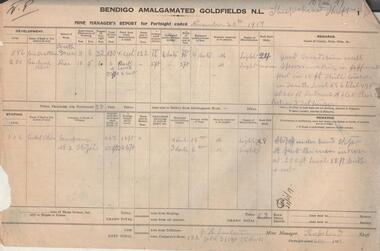
Administrative record - Bendigo Amalgamated Goldfields N.L. Mine Manager's Reports, 1917 - 1920
In 1917 Bendigo Amalgamated Goldfield Ltd was formed from the amalgamation of 35 companies with operations on the Garden Gully, Sheepshead, Deborah and Derby lines of reef hoping to increase profits of these existing operations through economies of scale. This was difficult to achieve as the shafts involved were spread throughout the goldfield. Diamond drilling and good geological practices were introduced (Pabst was Chief Geologist) leading to some exploration success. However costs were rising rapidly and in 1923 the directors, deciding that mining would soon become unprofitable, dissolved the company returning assets to the original vendors. J.H. Lenten, Mine Manager, received his second class Mine Manager's certificate in September, 1914 at an examination held at the Bendigo Law Courts. One hundred pages of fortnightly manager's reports for Bendigo Amalgamated Goldfields N.L., Sheepshead Shaft. Reports consist of two pages for each fortnight, signed by J.H. Lenten, Mine Manager. Dates of reports range from November 20th, 1917 to 5th May 1920. Categories reported on include: development, stoping, tons from tributors, tons Company's stone, plant and machinery, underground workings, number of rock drill shifts, firewood used, coal burnt, and general remarks. charcoal burnt., lifting waterbendigo, margaret roberts, , goldmining, bendigo amalgamated goldfields, sheepshead shaft, j.h. lenten, mine manager -
 Eltham District Historical Society Inc
Photograph - Digital Photograph, Alan King, Panton Hill Hotel, 27 March 2008
Today’s Panton Hill Hotel was built around 1920. Published: Nillumbik Now and Then / Marguerite Marshall 2008; photographs Alan King with Marguerite Marshall.; p61 Panton Hill was originally known as Kingstown, and consisted of only one hotel when the Orams Reef was discovered in 1859. Kingstown was a quartz mining centre and many old mine shafts remain in the area. Orams Reef was one of the first reefs with a rich find of gold in the area. The Hotel Francais, which had been operating in 1861, was well situated on the way to Queenstown (later St Andrews). So was Herr Hirt’s Hotel and store at Smiths Gully. The Kingstown hotel, known as the Frenchman’s and in 1864 as the Hotel de France, was run by a Monsieur Emile Hude and his wife Jeanne, and known for its good food. They hosted social events, business conventions and debates, attracting patrons from as far as Melbourne. The hotel’s name was changed to Panton Hill Hotel in 1905. In 1883 Charles Caudwell built another hotel nearby, possibly in Long Gully Road,3 which it is thought, was burnt down early last century. Today’s Panton Hill Hotel, built around 1920, is the only one of the cluster of buildings in the main road, not to date from around the turn of last century. It was severely damaged by fire in 2003, then underwent extensive alterations. It is the township’s only hotel and is an example of a modest hotel building exterior, constructed early last century. In its early days the hotel also housed the first post office, newsagency and store. Orams Reef yielded a total of £100,000, and fossikers also found alluvial gold in the creeks and gullies, but there is no record of the total value of their finds. Gold greatly increased the Panton Hill population, which peaked between 1865 and 1885. On holidays large sports meetings were held with wood chopping contests and foot races and the day would end with a ball. Miners came from various countries to seek their fortune, including many from China. The Chinese became unpopular however, and gradually left the district, although some stayed and grew and sold vegetables.5 Panton Hill was named after Joseph Panton, who in 1862 was appointed Police Magistrate for the Woods Point, Heidelberg and Yarra districts. Panton was an outstanding man, who in 1852, was Commissioner of Crown Lands and Assistant Commissioner of Goldfields at Bendigo. In 1874 he was promoted to Chief Magistrate for the Melbourne Police. Panton was also an artist, becoming president of the Victorian Arts Society in 1888, and in 1913, president of the Royal Geographical Society. Despite Panton Hill’s prosperity, it still lacked many services as poor roads made access to Melbourne difficult. A horse-drawn mail coach travelled to Melbourne until 1890, when the railway came to Heidelberg. The nearest doctor was at Yarra Glen or Heidelberg, and the Indian hawker Singh’s annual visit was very welcome. A miner’s shack opposite the school was used as a post office. Today’s general store and post office in the main road dates from early last century, and has changed considerably. While most people searched for gold, the more enterprising ones established farms to feed the diggers. Farmers grew wheat, barley and oats, and sent animal skins to the Eltham tannery, to make furs in Melbourne. As gold became scarce from around 1880, miners took up farming on 19 to 20 acre (8ha) allotments. The first settlers in Cherry Tree Road included Purcell, Smith, Owens, Hughes and Shillinglaw. By 1900 all the land had been taken up around Panton Hill and Hurstbridge. The orchards in Panton Hill and the wider district, particularly of apple and pear, were very successful, and made Panton Hill a cohesive and successful community. About 1914 the Moores built the first cool-store and refrigeration plant at their orchard in Cherry Tree Road. Many settlers planted vineyards and made high quality wine, but in 1922 the blight destroyed them.This collection of almost 130 photos about places and people within the Shire of Nillumbik, an urban and rural municipality in Melbourne's north, contributes to an understanding of the history of the Shire. Published in 2008 immediately prior to the Black Saturday bushfires of February 7, 2009, it documents sites that were impacted, and in some cases destroyed by the fires. It includes photographs taken especially for the publication, creating a unique time capsule representing the Shire in the early 21st century. It remains the most recent comprehenesive publication devoted to the Shire's history connecting local residents to the past. nillumbik now and then (marshall-king) collection, panton hill hotel -
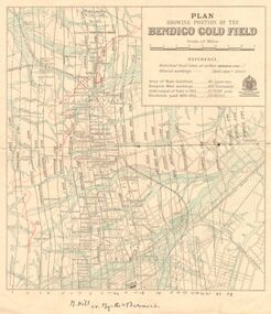 Bendigo Historical Society Inc.
Map - DEPARTMENT OF MINES VICTORIA : PLAN SHOWING PORTION OF THE BENDIGO GOLD FIELD
Department of Mines Victoria. Plan showing portion of the Bendigo Gold Field. On the back is written, in ink, J. J. Tyler 1937 Northern Area. (He was a teacher at Bendigo High - see donation notes). Across the bottom of the map is written ' M. Hill cr. Myrtle & Barnard' .The named reef lines have been numbered with ink across the bottom of the map. The gullies have been coloured with green pencil and a red pencil line is drawn through the western side of the map. Additional information: anticlinal axial lines at surface, alluvial workings, shaft sites, area of Main Goldfield, Deepest mine workings, Gold output of field to 1935, and Dividends paid 1870 - 1935.bendigo, gold mining, bendigo gold field. gold mining. tyler, j. j. -
Clunes Museum
Newspaper - NEWSPAPER CUTTING, ARGUS AGE, 1 CLUNES BIRTHDAY .2 FAMOUS MINING TOWNS, 4 - 7 - 1931 27 - 8 - 32
NEWSPAPER HEADLINES. CLUNES BIRTHDAY. FAMOUS MINING TOWNS .1. 80TH ANNIVERSARY JULY 4, 1931 .2. THE QUARTZ REEFS OF CLUNES. SOME INTERESTING DOCUMENTS..2 NEWSPAPER CUTTINGS. .1. CLUNES MINING 80TH ANNIVERSARY JULY 4, 1931 .2. THE QUARTZ REEFS OF CLUNES. SOME INTERESTING DOCUMENTS.local history, document, newspaper cutting, mining -
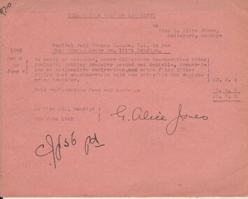 Bendigo Historical Society Inc.
Document - MISS G ALICE JONES COLLECTION: ACCOUNT
Nell Gwynne Reef NO Liability to Miss G. Alice Jones. Pink paper dated Feb. 3 to June 4, 1942, 9 June 1942 and 9th June 1942. Re Central Nell Gwyne G. M. Co. N. L. to you Gold Mining Lease No. 11171 Bendigo. Account for costs for transfer, registration fees and exchange. Total cost £5. 7. 0. "R710" written in top left corner. Signed by G. Alice Jones.miss g. alice jones collection - account, nell gwynne reef n. l., central nell gwynne g. m. co n. l., lease no 11171 -
 Bendigo Historical Society Inc.
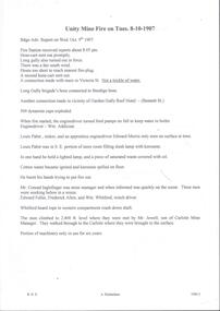
Document - ULSTER GOLD MINING COMPANY NO LIABILITY - UNITY MINE FIRE 8/10/1907 & FAMOUS GOLD MINES
Typed copy of recount by Albert Richardson of a fire at Unity Mine on Tuesday 8-10-1907. Report from the Bendigo Advertiser Wednesday October 9th 1907. Notes mention Fire Brigade, miners, how the fire started and how the men down the shaft escaped when the rope crash down the shaft. On the back is a handwritten carbon copy of notes titled Famous Gold Mines of Bendigo and Eaglehawk. Notes give yields of gold for alluvial and quartz mining. Deep Shafts in 1904 of which there were eleven with a depth of more than 3000 feet and 53 over 2000 feet and two which were more than 4000 feet. Wages for 1911 for Engine Drivers and Firemen and Boiler Attendants. Note on winding plants and air compressors.document, gold, ulster gold mining coy no liability, ulster gold mining company no liability, unity mine fire 8/10/1907, bendigo advertiser 9/10/1907, garden gully reef hotel, wm addicoat, louis pabst, edward morris, conrad inglefinger, edward fuller, frederick allen, wm whitford, mr jewell, carlisle mine, famous gold mines of bendigo and eaglehawk, new chum line, garden gully line, hustlers line, victoria quartz mine, new chum railway, mines report 1911 p15, albert richardson -
 Bendigo Historical Society Inc.
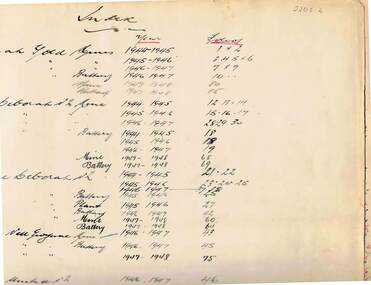
Document - MCCOLL, RANKIN AND STANISTREET COLLECTION: WAGES BOOK, VARIOUS MINING COMPANIES, 1945-50
Document: McColl, Rankin and Stanistreet: Deborah: wages book, various mining companies. Listing wages and tax paid for employees of : Deborah Gold Mines and batteries, North Deborah mine and batteries, Central Deborah mine and batteries,, Central Nell Gwynne, Deborah United No. 2, South Deborah, Deborah Extended, Nell Gwynne Reef, East Clarence, Golden Carshalton, North Virginia. Indexed in front cover.organization, mining, mccoll, rankin and stanistreet, mccoll, rankin and stanistreet: gold mining, deborah mines -
 Eltham District Historical Society Inc
Photograph - Digital Photograph, Marguerite Marshall, One Tree Hill Mine, Smiths Gully, 8 June 2006
Gold was discovered on One Tree Hill in 1854. The site has been worked intermittently until fairly recent times. Published: Nillumbik Now and Then / Marguerite Marshall 2008; photographs Alan King with Marguerite Marshall.; p53 Though still a working mine, One Tree Hill Mine at Smiths Gully, now stands in a tranquil reserve surrounded by bush and native animals - in contrast to its heyday. In the mid 19th century, when the mine was part of the Caledonia Goldfields, hundreds of men in search of their fortune worked the alluvial gold in the Yarra River, its tributaries and the reefs that made up the goldfields. Miner Stan Bone, assisted by Wilfred Haywood, is the last of the independent gold miners in the area and still uses the quartz crushing battery as miners did when gold was first discovered in the area in 1851.1 Stan, who is the last of six generations of miners in his family, was aged 17 when he began mining on his father Alex’ mine, The Golden Crown in Yarrambat. These days, after blasting the gold-bearing rock in Mystery Reef, one of the four reefs at One Tree Hill, Stan transports it around five kilometres by tip truck to the Black Cameron Mine for crushing. There he uses water from the waterlogged mine, (which still contains gold), as the Happy Valley Creek at One Tree Hill is usually dry.2 The One Tree Hill Mine has been worked for close to a century since it opened around the late 1850s.3 The Swedish Reef was its most productive reef and one of the largest in the area. Around 1859, extractions included 204 ounces (5.8kg) of gold, won from 57 pounds (26kg) of stone.4 Then during World War Two, Stan’s uncle, Bill Wallace, and Alex Bone, closed the mine. In 1973, Stan, with his Uncle Bill, reopened the Black Cameron Mine and worked there until 1988. Stan resumed mining One Tree Hill in 1998. As late as the 1920s gold was picked up by chance! When crossing a gully on his way to vote at the St Andrews Primary School, Bill Joyce picked up some quartz containing gold. This site was to become the Black Cameron Mine. The Caledonia Diggings, named after Scotland’s ancient name by local Scots, began around Market Square (now Smiths Gully) and included Queenstown (St Andrews), Kingstown (Panton Hill) and Diamond Creek. There were also poorer bearing fields in Kangaroo Ground and Swipers Gully (now Research). * None of these compared in riches to the Ballarat and Bendigo fields5, but the Caledonia Diggings continued intermittently for close to 100 years. Gold was discovered in Victoria following a bid to stem the disappearance of much needed workmen to the New South Wales diggings. Several businessmen offered a reward of £200, for the discovery of gold within 200 miles (322 km) of Melbourne. Late in June 1851, gold was first discovered at Andersons Creek, Warrandyte. Then in 1854, George Boston and two other men discovered gold at Smiths Gully. Gold transformed the quiet districts, with a constant flow of families and vehicles on the dirt tracks en route to the Caledonia Diggings. Three thousand people worked the gullies in Market Square, including about 1000 Chinese miners. The square established its own police, mining warden, gold battery, school, shops and cemetery and grog flowed. Market Square flourished until the middle 1860s. Bullocks transported quartz from the Caledonia Goldfields to the crushing machinery at the Queenstown/St Andrews Battery, near Smiths Gully Cemetery. It was destroyed by bushfire in 1962. By the late 1850s, most early alluvial fields were in decline, but minor rushes continued until around 1900 and some until the early 1940s. Some miners did well, although most earned little from their hard labour in the harsh and primitive conditions.6 But according to historian, Mick Woiwod, the gold fields helped to democratise society, as individuals from all walks of life were forced to share experiences, and the ability to succeed, depended less on inherited wealth or social rank.This collection of almost 130 photos about places and people within the Shire of Nillumbik, an urban and rural municipality in Melbourne's north, contributes to an understanding of the history of the Shire. Published in 2008 immediately prior to the Black Saturday bushfires of February 7, 2009, it documents sites that were impacted, and in some cases destroyed by the fires. It includes photographs taken especially for the publication, creating a unique time capsule representing the Shire in the early 21st century. It remains the most recent comprehenesive publication devoted to the Shire's history connecting local residents to the past. nillumbik now and then (marshall-king) collection, gold mining, one tree hill mine, smiths gully -
 Eltham District Historical Society Inc
Photograph - Digital Photograph, Alan King, Site of the Diamond Creek Gold Mine, 28 December 2007
The largest gold mine in the area originated from a find in 1862. The mine was closed January 20, 1915 when a fire destroyed nearly all the above ground plant. Published: Nillumbik Now and Then / Marguerite Marshall 2008; photographs Alan King with Marguerite Marshall.; p75 Beneath Mine Hill, as locals call it, runs a network of tunnels once of central importance to the fledgling township of Diamond Creek. These are relics of gold mines, which transformed early Diamond Creek.1 The tiny settlement of about 20 families soared to more than 200 because of gold. For around 50 years, from 1862, gold mining was Diamond Creek’s major source of employment. On September 7, 1854 The Argus newspaper reported a find of a four pound (1.8kg) gold nugget in Nillumbik (an early name for Diamond Creek). Exactly where, is not known.2 The largest mine in the district, the Diamond Creek Gold Mine, apparently originated from a find in 1862. It is said Joe and Dave Wilson were visiting former tailor then cook, Charles Orme, at the southern end of Fraser Street. Sitting on a stump outside the front gate on land belonging to Dr A. E. Phipps the Wilsons found a vein of gold-bearing quartz, which led to the discovery of four quartz reefs varying in width to eight inches (20cm), running north and south. A reef found at the foot of the hill opposite Challenger Street became the Union Mine. This reef was traced south to Allendale Road where a small mine began operations.3 Other smaller mines later operated as well. Dr Phipps immediately began to mine and also built the Diamond Reef Hotel as a boarding house for miners. But Charles Orme, who owned the land alongside, leased his mine to Dr Phipps probably because of insufficient funds and business skills. By mid 1865 the mine had produced 2530 ounces of gold – a 100% profit on the original outlay. Of course there were problems. When the local dam dried up a Blake pump was installed to draw water from the creek. The Union Mine operated under the Diamond Creek Gold Mine management except when disputes sometimes resulted in separate management. However disagreements had to be resolved as the Union Mine depended on Diamond Creek Gold Mine pumps to remove underground water from common reefs. In 1912 the main shaft of about 380 yards (350m) employed 200 men recovering an average of 5000 ounces (141.7kg) of gold a year. But not everyone did well out of gold. Records of failed mining companies in the Victorian Public Record Office, reveal that owner Dr Phipps leased his Right to others. Companies came and went over the next 40 years, most sponsored by Melbourne businessmen who sold shares to gullible locals and then became insolvent. Although there were some good profits, financial returns were haphazard until 1905. Some local residents, who were share holders in short- term companies, became well-known names in modern Diamond Creek such as Scott, Haley, Butler, Alder, Ryan, Wadeson, Reeves, Alston, Paul and Edwards. Gold mining was brought to a disastrous end on January 20, 1915 at 3 pm, when fire destroyed nearly all the above-ground plant. Fortunately no lives were lost. But reopening the mine was almost impossible because of the increasing depth of water in the main shaft. The closed mine destroyed the livelihood of 200 families and the debris took many years to clear.4 In 1946 the Diamond Creek Gold Mine was reopened by the Golden Hind Mining Company, but money ran out before the 600 feet (182.8m) or so of water could be removed. Gold remains in the mine but enormous capital would be needed to buy the land, equipment and to remove the water. Today 12 known sealed shafts along the ridge of the hills on private property extend west for around one kilometre from the corner of Fraser and Haley Streets, crossing Norma and Fyffe to Dering Streets. As recently as 1987, heavy rains revealed a former Union Mine shaft in the Georgiadis family Fyffe Street back yard.5 Allendale Mine, south of Allendale Road, is still open and one of the Union Mine’s main drives (horizontal excavation) remains unsealed, on the Creek Reserve.This collection of almost 130 photos about places and people within the Shire of Nillumbik, an urban and rural municipality in Melbourne's north, contributes to an understanding of the history of the Shire. Published in 2008 immediately prior to the Black Saturday bushfires of February 7, 2009, it documents sites that were impacted, and in some cases destroyed by the fires. It includes photographs taken especially for the publication, creating a unique time capsule representing the Shire in the early 21st century. It remains the most recent comprehenesive publication devoted to the Shire's history connecting local residents to the past. nillumbik now and then (marshall-king) collection, diamond creek, diamond creek mine, fraser street, gold mining, james cook drive, mine hill -
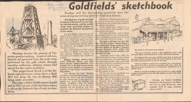 Bendigo Historical Society Inc.
Newspaper - GOLDFIELDS SKETCHBOOK ARTICLE, BENDIGO ADVERTISER, 23rd July 1970
Newspaper article titled' Goldfields' sketchbook. Article on book release ' Bendigo and Eastern Goldfields Sketchbook with Drawings by Unk White and text by John Bechervaise, first published 1970, 64 pages, hardback edition, $1.95. Extract from article ' our poppet-head sketch is of the Deborah superstructure, rising above a shaft 2017 feet deep, the site on Quarry Hill being easily accessible. The mine yielded 52,000 ounces of gold and in 1954 was one of the last three mines all on the Deborah line of reef, to close down'Bendigo Advertiser July 23rd 1970.bendigo, mining, gold discovery, 'bendigo advertiser -
 Bendigo Historical Society Inc.
Document - MARKS COLLECTION: MINING LEASE BLOCKS 1873
Plan mining lease blocks 1873, timber hanger on top two brass rings, securing tape, round timber holder on bottom, scroll. On top Schedule of Mining Lease Blocks shown on the plan of the Sandhurst Gold Field, Published May 1873' Names of mining Companies listed with identifying number and area of mine site. E.g. '447 Johnson's Reef Gold Mines 7a, 2r, 8 p (acres, roods, perches). Number linked to the mine site shown on Sandhurst Gold Field map.bendigo, mining, mining lease blocks 1873 -
Bendigo Historical Society Inc.
Document - DIAMOND HILL, GLASGOW GOLCONDA REEF GOLD MINE
BHS CollectionDescription of the heritage values of the Glasgow Golconda Reef Gold Mine sites. Information taken from 'On My doorstep' website ( no longer available, 10/2022)bendigo, mining, glasgow golconda -
 Bendigo Historical Society Inc.
Administrative record - Kong Meng Gold Reefs Share Register, 1935 to 1936
Three hundred and fifty three page share register, dark green cover, buff bindings. On spine of register in gold text, printed on maroon background :" Share Register' and 'Kong Meng Gold Reefs N.L.' printed in gold on brown background. Alphabetical index of share holders in front of register. Dates range from 1935 to 1936. Share register is part of the Margaret Roberts Collection. bendigo, gold mining, shareholders, share transfers, kong meng gold reefs, dargo, margaret roberts collection, mccoll rankin and stanistreet -
 Bendigo Historical Society Inc.
Administrative record - South Nell Gwynne G.M. Co. N.L. Share Register, 1939 to 1941
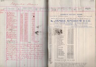
See Geological Survey Victoria: GSV Reference ID: 43711 South Nell Gwynne 'The Central Nell Gwynne which recently took over the reef prospected by Nell Gwynne ( B.M.L.) will continue to work the mine until the new Company, South Nell Gwynne Gold Mining Company is ready to take over. The main development work is at the 1080 feet level where stoping is being carried out on a spur system which has shown several colours of gold. ...The trial crushing in shaft sinking gave 4 dwt per gold per ton..... ' ( 29th July 1938, 'The Herald, Melbourne) 1941 Geological Survey Vic: SOUTH NELL GWYNNE, BENDIGO. MINING AND GEOLOGICAL JOURNAL: ' Journal, dark green hard cover, buff bindings on spine and corners. On spine of book in gold print: ' Share Register South Nell Gwynne G.M. Co. N.L.' South Nell Gwynne Gold Mining Company share register, 1938 to 1941. Alphabetical index in front, four hundred pages. Entries detail date of purchase, name of shareholder, distinctive number range, call account and paid by. Page 299 has a list of forfeited shares in the Company with a list of shares sold by James Andrew & Co., on 8th December 1938. Shares were 'forfeited for non payment of the 2nd call of threepence per share'. Share register is part of the Margaret Roberts Collection. bendigo, goldmining, goldfield, south nell gwynne gold mining co., nell gwynne, margaret roberts collection, mr j.j. stanistreet, mine manager -
Bendigo Historical Society Inc.
Document - BENDIGO & SANDHURST GOLD MINING COMPANIES FROM 1872, 1872-1950
Typed copy of the Bendigo & Sandhurst Gold Mining Companies From 1872. Vol 1 Victorian Government Gazettes. Eight pages. Includes Mine name, Reef/Gully, Place/Suburb, Mine Managercottage, miners, mechanics institute, old masonic hall, court, st killians, forrest st methodist church, hospital, baptist church, bendigo gas company, st andrews presbyterian church, bendigo benevolent home, railway, st marys church of england, bendigo m p building society, st pausl church of england, high school, city family hotel, fire brigade, b u f s dispensary, synagogue, beehive store, school of mines, bendigo miners association, st marys convent, dr backhaus, st mathews long gully, salvation army, post office, art gallery, sacred heart cathedral, eaglehawk town hall