Showing 495 items
matching river boats
-
 Lakes Entrance Historical Society
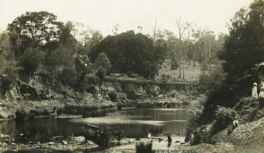
Postcard - Nicholson River, Bulmer and Segenberg Bairnsdale, 1910
... on river at wide bend 05350.1 8.5 x 13.5 cm Waterways Boats ...Also a second black and white postcard showing two rowboats on river at wide bend 05350.1 8.5 x 13.5 cmBlack and white postcard showing view of Upper Nicholson River with three women shown, water level low Nicholson VictoriaNicholson River waterways, boats and boating -
 Lakes Entrance Historical Society
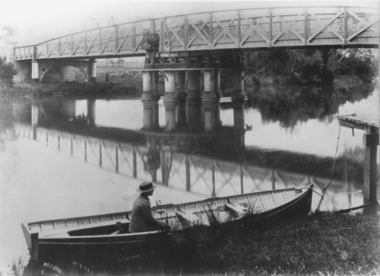
Photograph, Caire, Nicholas John, Swing Bridge Sale Victoria c1905, 1905c
Latrobe Bridge Sale Victoria in closed position . The operating machinery is still visibleBlack and white photograph of the Latrobe Bridge, in its closed position. The operating machinery is visible, plus the unique pier structure of the central span. In the rowing boat moored along side the river bank, a person wearing a boater hat is seated. Sale Victoriawaterways, bridges, civil engineering -
 Lakes Entrance Historical Society
Photograph - PS Tanjil, 1880 c
PS Tanjil was burnt to the waterline in February 1885Black and white photograph of the first PS Tanjil in the Mitchell Rivers Bairnsdale Victoriaboats and boating, waterways -
 Port of Echuca
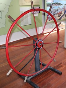
Instrument - Steering Wheel, PS Success, 1877
This steering wheel is from the PS Success. The PS Success was built in Moama in 1877 by GB Air for Westwood & Air. The Success towed barges of sawn red gum, wool & other cargo along the Darling and Murray Rivers as well as running as a passenger boat from Swan Hill to Mildura during 1915-16. The Success ended her working life in 1957 and was put up on the bank at Neds Corner, 80kms west of Mildura. The PS Success was donated to the Riverboat Historical and Preservation Society of Mildura with plans for full restoration but with funds becoming extremely difficult to secure, the Shire of Campaspe was approached to take ownership in 2009 to enable further restoration when possible. The Riverboat Preservation Society also donated this original steering wheel.The PS Success was an important vessel built in the Echuca area during the height of the Riverboat trade in the 1870s. She had a long, colourful history towing barges on the Murray River and in particular in the Mildura, Wentworth and Ned's Corner regions. Importantly, the Success was the last paddlesteamer to be working on the river system right up until the 1956 floods rescuing sheep and wool. The steering wheel is an important original element of the PS Success and her hopes for restoration one day. Red metal steering wheel with 10 spokes sitting on a heavy iron wheel stand. -
 Lakes Entrance Historical Society
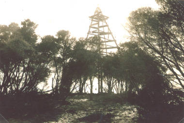
Photograph - Timber Beacon Gippsland Lakes, Vacinity of Raymond Island Victoria, 1900 c
On back of original Raymond Island Tambo River in distance. This survey lookout has been washed away, seawater has killed vegetation and allowed erosionBlack and white photograph of a timber beacon on land in Gippsland Lakes in vacinity of Raymond Island Victoriaboats and boating, navigation, waterways -
 Chelsea & District Historical Society Inc
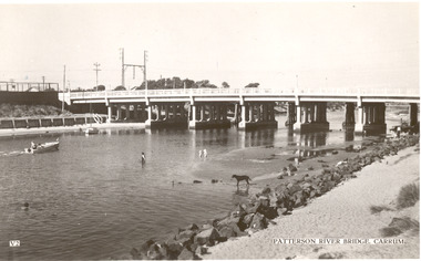
Photograph - Patterson River, Rail and Road Bridge, Carrum
The first bridge over the river was built in the early 1880's, prior to this it was a pontoon bridge. In 1927 a concrete bridge was built to replace the wooden bridge.Black and white photo of Patterson River, taken from Beauty Point, Carrum Victoria. patterson river, chelsea, patterson river bridge, carrum bridge, beach, leisure, beauty point, boats -
 Lakes Entrance Historical Society
Photograph - Building of PS Curlip, 1/01/2006 12:00:00 AM
building of PS Curlip replica in old butter factory building Orbost VictoriaBuilt as tourist attraction on river at Marlo. Plus 6 other photos Colour photograph showing building of PS Curlip replica in old butter factory building Orbost Victoria. Plus 9 other photos tourism, boat building -
 Chelsea & District Historical Society Inc
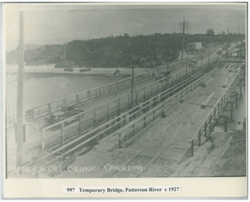
Photograph - Patterson River, Temporary and Old Bridge, c 1927
The first bridge over the river was built in the early 1880's, prior to this it was a pontoon bridge. In 1927 the construction of a concrete bridge was undertaken.Black and white photo of the old wooden road bridge (Point Nepean / Nepean Highway), and a temporary bridge over Patterson River, Carrum near the mouth of the river. Cars using the old bridge. Rowing boats on shore. Temporary and old bridge, Carrumpatterson river, road bridge, rail bridge, chelsea, transport, patterson river bridge, carrum bridge, temporary bridge, cars -
 Lakes Entrance Historical Society
Photograph - steamer landing on Tambo River East Gippsland Victoria, 1900 c
... A popular Sunday outing venue was at Tambo Upper Rivers ...A popular Sunday outing venue was at Tambo UpperCopy of black and white photographic print showing large picnic party, steamer possibly Tanjil in background at a steamer landing on Tambo River between Swan Reach and Bruthen East Gippsland Victoriarivers, boats and boating, steamers -
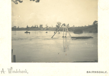 Lakes Entrance Historical Society
Photograph - floods in Mitchell River at Port of Bairnsdale Victoria, A Windeback, 1903 c
... floodwaters Bridges Boats and Boating Rivers Floods Black and white ...Super structure of wharf crane just visible above floodwatersBlack and white photograph mounted on heavy card of floods in Mitchell River at Port of Bairnsdale Victoriabridges, boats and boating, rivers, floods -
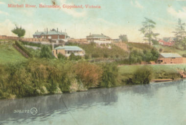 Lakes Entrance Historical Society
Photograph - Mitchell River Bairnsdale Victoria, 1910 c
Copy of old hand coloured postcard of Mitchell River showing St Johns Church top right, rowing club boat shed bottom right with steps down to river and landing Bairnsdale VictoriaMitchell River Bairnsdale Gippsland Victoriabridges, rivers, churches -
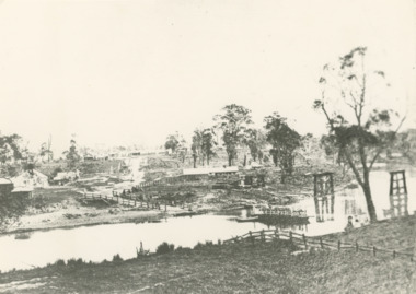 Lakes Entrance Historical Society
Photograph - Mitchell River Bairnsdale Victoria, F Cornell, 1870
... Boats and Boating Businesses Rivers Black and white ...Black and white photograph of the punt on the Mitchell River and the first bridge under construction. In distance can be seen the growing township of Bairnsdale Victoriaboats and boating, businesses, rivers -
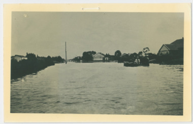 Chelsea & District Historical Society Inc
Photograph - Chelsea Flood December 1934, Men in boat delivering supplies
In December 1934, 700 houses were inundated with water, when the Dandenong Creek and Patterson River broke their banks.Black and white photo of four men in a life boat taking supplies to houses and farmsflood, chelsea, dandenong creek, fowler street, sherwood avenue -
 Chelsea & District Historical Society Inc
Photograph - Chelsea Flood December 1934, Delivering Food
In December 1934, 700 houses were inundated with water, when the Dandenong Creek and Patterson River broke their banks.Black and white photo of five men in a life boat delivering rations to flood victims, landing at Wells Road. One of the men is Livock.flood, chelsea, dandenong creek, wells road -
 Lakes Entrance Historical Society
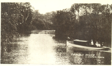
Photograph, A Cooper, Tambo River ,Tambo Victoria, 1908 1909 c
... Black and white photograph of a motor boat on Tambo River... photo Black and white photograph of a motor boat on Tambo River ...Reference from Gippsland in Focus, Debra Squires, Linda Barraclough, Helen ClothierBlack and white photograph of a motor boat on Tambo River with four people on board Tambo VictoriaTambo River A Cooper photo waterways, rivers -
 Lakes Entrance Historical Society
Postcard, W S Vogt Bairnsdale, Tambo River Swan Reach Victoria, 1925 c
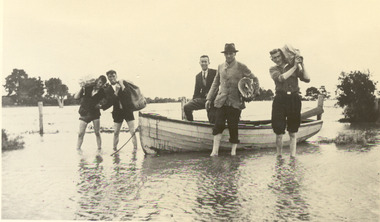
... Archie MacArthers boat Gowrie Boats and Boating Rivers Tourism ...Note with photograph says This is a view of the Tambo River about a mile and a half up from where I am staying. The river here is narrow owing to cliffs with love from Arthur. Maybe Archie MacArthers boat GowrieSepia toned postcard of a passenger launch on the Tambo River below the cliffs upstream from Swan Reach Victoriaboats and boating, rivers, tourism -
 Lakes Entrance Historical Society
Photograph, Tambo River looking upstream from McMeekins Killarney Tambo Upper Victoria, 1/02/2024 12:00:00 AM
Black and white photograph of view of Tambo River looking upstream from McMeekins Killarney Tambo Upper Victoria. Also two similar photographs of Tambo River boats and boating, waterways -
 Lakes Entrance Historical Society
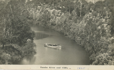
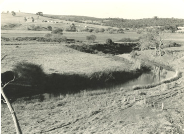
Photograph, G Legg Bairnsdale, Tambo River at Mossiface Victoria, `1970 1980 c
... to the Port of Mossiface Boats and Boating Rivers Black and white ...This narrow waterway was the original steamer route to the Port of MossifaceBlack and white photograph of the Tambo River adjoining Arthur Howletts property at Mossiface Victoriaboats and boating, rivers -
 National Vietnam Veterans Museum (NVVM)
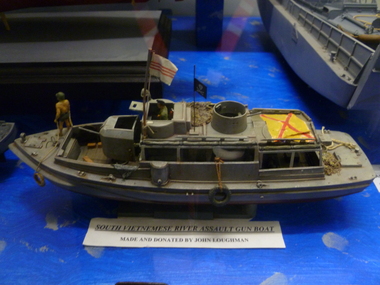
Model, South Vietnam River Assault Boat
... South Vietnam River Assault Boat...River assault boat...Model Boat Vietnamese boat River assault boat South Vietnam ...A model boat that has one person at the front holding robe and another person is inside the cockpit. The boat has three flags, one on deck with yeallow colour and red "X", one is white with three red horizontal stripesin middle on pole next to cockpit and one look like a pirate flag behind the cockpit.South Vietnam Assault Gun Boatmodel boat, vietnamese boat, river assault boat -
 Lakes Entrance Historical Society
Photograph, SS Bellbird , Tambo River at Johnsonville
... Tourism Boats and Boating Rivers Black and white photograph ...Black and white photograph of SS Bellbird after its launch on Tambo River at Johnsonvilletourism, boats and boating, rivers -
Bendigo Historical Society Inc.
Map - Black and white map pertaining to Lake Eppalock
John Perry Collection. Laminated copy of map relating to Lake Eppalock. Lists dwellings, ford crossings and bridges. The dam was built by the State Rivers and Water Supply Commission of Victoria. The dam wall height is 45 metres (148 ft) and the main embankment is 1,041 metres (3,415 ft) long. At 100% capacity the dam wall was designed to hold back 304,651 megalitres (6.7014×10¹⁰ imp gal; 8.0480×10¹⁰ US gal) of water. The surface area of Lake Eppalock is 3,011 hectares (7,440 acres) and the catchment area is 2,124 square kilometres (820 sq mi). The controlled spillway is capable of discharging 8,040 cubic metres per second (284,000 cu ft/s). Lake Eppalock supplies both stock and domestic water to the Campaspe irrigation district. It also serves as a water supply to Bendigo and Heathcote and, in more recent times, Ballarat. The lake is a major attraction for those engaging in watersports, with a number of tourist parks and accommodation facilities available. Permissible activities on the lake include high-speed boating, water skiing, sailing, canoeing, fishing and swimming. The lake's water levels were low for approximately eight years between 2002 and 2010 during a prolonged drought, which restricted the amount of recreational activity until rainfall in the latter half of 2010 returned the lake to 100 percent capacity. Built between 1961 and 1964, Lake Eppalock remains the only water storage on the Campaspe River system.map, water, dam, reservoir, eppalock -
Bendigo Historical Society Inc.
Map - Black and white map pertaining to Lake Eppalock
John Perry Collection. Laminated copy of map pertaining to Lake Eppalock. Gives details of dwellings, bridges and ford crossings. The dam was built by the State Rivers and Water Supply Commission of Victoria. The dam wall height is 45 metres (148 ft) and the main embankment is 1,041 metres (3,415 ft) long. At 100% capacity the dam wall was designed to hold back 304,651 megalitres (6.7014×10¹⁰ imp gal; 8.0480×10¹⁰ US gal) of water. The surface area of Lake Eppalock is 3,011 hectares (7,440 acres) and the catchment area is 2,124 square kilometres (820 sq mi). The controlled spillway is capable of discharging 8,040 cubic metres per second (284,000 cu ft/s). Lake Eppalock supplies both stock and domestic water to the Campaspe irrigation district. It also serves as a water supply to Bendigo and Heathcote and, in more recent times, Ballarat. The lake is a major attraction for those engaging in watersports, with a number of tourist parks and accommodation facilities available. Permissible activities on the lake include high-speed boating, water skiing, sailing, canoeing, fishing and swimming. The lake's water levels were low for approximately eight years between 2002 and 2010 during a prolonged drought, which restricted the amount of recreational activity until rainfall in the latter half of 2010 returned the lake to 100 percent capacity. Built between 1961 and 1964, Lake Eppalock remains the only water storage on the Campaspe River system.eppalock, map, water, dam, reservoir -
 Lakes Entrance Historical Society
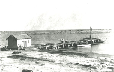
Photograph - Snowy River.Marlo Victoria, 1910 c
... Rivers Boats and Boating Jetties Black and white photograph ...Black and white photograph showing four small boats at jetty near mouth of Snowy River. Shed at left crane at end of jetty. Three ladies walking on jetty and people in front of shed and three people sitting in shade of shed at left. Trolly on rails on jetty, sand dunes across river and ocean beyond dunes Marlo Victoriarivers, boats and boating, jetties -
Bendigo Historical Society Inc.
Document - Directions to Lake Eppalock with road descriptions and map
John Perry Collection. Laminated copy of 'Directions to Lake Eppalock'. Gives directions in relationship of Lake Eppalock to Bendigo, Kyneton and Heathcote. Undated. Gives basic descriptions of bridges on lakebed, ford crossings on lakebed and inundated dwellings on lakebed. The dam was built by the State Rivers and Water Supply Commission of Victoria. The dam wall height is 45 metres (148 ft) and the main embankment is 1,041 metres (3,415 ft) long. At 100% capacity the dam wall was designed to hold back 304,651 megalitres (6.7014×10¹⁰ imp gal; 8.0480×10¹⁰ US gal) of water. The surface area of Lake Eppalock is 3,011 hectares (7,440 acres) and the catchment area is 2,124 square kilometres (820 sq mi). The controlled spillway is capable of discharging 8,040 cubic metres per second (284,000 cu ft/s). Lake Eppalock supplies both stock and domestic water to the Campaspe irrigation district. It also serves as a water supply to Bendigo and Heathcote and, in more recent times, Ballarat. The lake is a major attraction for those engaging in watersports, with a number of tourist parks and accommodation facilities available. Permissible activities on the lake include high-speed boating, water skiing, sailing, canoeing, fishing and swimming. The lake's water levels were low for approximately eight years between 2002 and 2010 during a prolonged drought, which restricted the amount of recreational activity until rainfall in the latter half of 2010 returned the lake to 100 percent capacity. Built between 1961 and 1964, Lake Eppalock remains the only water storage on the Campaspe River system.water, dam, directions, eppalock -
Bendigo Historical Society Inc.
Document - Legend to maps A, B and C for Lake Eppalock
John Perry Collection. Laminated 'legend' for Maps A, B and C for Lake Eppalock also in this collection. Black and White definitions and descriptions of objects and markers found on maps. Circa 1951. The dam was built by the State Rivers and Water Supply Commission of Victoria. The dam wall height is 45 metres (148 ft) and the main embankment is 1,041 metres (3,415 ft) long. At 100% capacity the dam wall was designed to hold back 304,651 megalitres (6.7014×10¹⁰ imp gal; 8.0480×10¹⁰ US gal) of water. The surface area of Lake Eppalock is 3,011 hectares (7,440 acres) and the catchment area is 2,124 square kilometres (820 sq mi). The controlled spillway is capable of discharging 8,040 cubic metres per second (284,000 cu ft/s). Lake Eppalock supplies both stock and domestic water to the Campaspe irrigation district. It also serves as a water supply to Bendigo and Heathcote and, in more recent times, Ballarat. The lake is a major attraction for those engaging in watersports, with a number of tourist parks and accommodation facilities available. Permissible activities on the lake include high-speed boating, water skiing, sailing, canoeing, fishing and swimming. The lake's water levels were low for approximately eight years between 2002 and 2010 during a prolonged drought, which restricted the amount of recreational activity until rainfall in the latter half of 2010 returned the lake to 100 percent capacity. Built between 1961 and 1964, Lake Eppalock remains the only water storage on the Campaspe River system.map, water, dam, reservoir, eppalock -
Bendigo Historical Society Inc.
Map - Map of overlay of lake Eppalock at full capacity. Map 'C'
John Perry collection. Map 'C'. Laminated map of overlay of Lake Eppalock at full capacity. Circa 1951. The dam was built by the State Rivers and Water Supply Commission of Victoria. The dam wall height is 45 metres (148 ft) and the main embankment is 1,041 metres (3,415 ft) long. At 100% capacity the dam wall was designed to hold back 304,651 megalitres (6.7014×10¹⁰ imp gal; 8.0480×10¹⁰ US gal) of water. The surface area of Lake Eppalock is 3,011 hectares (7,440 acres) and the catchment area is 2,124 square kilometres (820 sq mi). The controlled spillway is capable of discharging 8,040 cubic metres per second (284,000 cu ft/s). Lake Eppalock supplies both stock and domestic water to the Campaspe irrigation district. It also serves as a water supply to Bendigo and Heathcote and, in more recent times, Ballarat. The lake is a major attraction for those engaging in watersports, with a number of tourist parks and accommodation facilities available. Permissible activities on the lake include high-speed boating, water skiing, sailing, canoeing, fishing and swimming. The lake's water levels were low for approximately eight years between 2002 and 2010 during a prolonged drought, which restricted the amount of recreational activity until rainfall in the latter half of 2010 returned the lake to 100 percent capacity. Built between 1961 and 1964, Lake Eppalock remains the only water storage on the Campaspe River system.map, water, eppalock, dam, reservoir -
Bendigo Historical Society Inc.
Map - Laminated map of Lake Eppalock empty. Map 'D'
John Perry Collection. Laminated map of Lake Eppalock empty. Map 'D'. Circa 1951. The dam was built by the State Rivers and Water Supply Commission of Victoria. The dam wall height is 45 metres (148 ft) and the main embankment is 1,041 metres (3,415 ft) long. At 100% capacity the dam wall was designed to hold back 304,651 megalitres (6.7014×10¹⁰ imp gal; 8.0480×10¹⁰ US gal) of water. The surface area of Lake Eppalock is 3,011 hectares (7,440 acres) and the catchment area is 2,124 square kilometres (820 sq mi). The controlled spillway is capable of discharging 8,040 cubic metres per second (284,000 cu ft/s). Lake Eppalock supplies both stock and domestic water to the Campaspe irrigation district. It also serves as a water supply to Bendigo and Heathcote and, in more recent times, Ballarat. The lake is a major attraction for those engaging in watersports, with a number of tourist parks and accommodation facilities available. Permissible activities on the lake include high-speed boating, water skiing, sailing, canoeing, fishing and swimming. The lake's water levels were low for approximately eight years between 2002 and 2010 during a prolonged drought, which restricted the amount of recreational activity until rainfall in the latter half of 2010 returned the lake to 100 percent capacity. Built between 1961 and 1964, Lake Eppalock remains the only water storage on the Campaspe River system.map, water, dam, reservoir, eppalock -
Bendigo Historical Society Inc.
Document - Collection of photographs from newspaper on a single page
John Perry Collection. Laminated copy of page from 'Weekly Times' newspaper, February, 1962. Nine images relating to establishing and building Eppalock Reservoir, 15 miles from Bendigo. The dam was built by the State Rivers and Water Supply Commission of Victoria. The dam wall height is 45 metres (148 ft) and the main embankment is 1,041 metres (3,415 ft) long. At 100% capacity the dam wall was designed to hold back 304,651 megalitres (6.7014×10¹⁰ imp gal; 8.0480×10¹⁰ US gal) of water. The surface area of Lake Eppalock is 3,011 hectares (7,440 acres) and the catchment area is 2,124 square kilometres (820 sq mi). The controlled spillway is capable of discharging 8,040 cubic metres per second (284,000 cu ft/s). Lake Eppalock supplies both stock and domestic water to the Campaspe irrigation district. It also serves as a water supply to Bendigo and Heathcote and, in more recent times, Ballarat. The lake is a major attraction for those engaging in watersports, with a number of tourist parks and accommodation facilities available. Permissible activities on the lake include high-speed boating, water skiing, sailing, canoeing, fishing and swimming. The lake's water levels were low for approximately eight years between 2002 and 2010 during a prolonged drought, which restricted the amount of recreational activity until rainfall in the latter half of 2010 returned the lake to 100 percent capacity. Built between 1961 and 1964, Lake Eppalock remains the only water storage on the Campaspe River system. dam, engineering, water, eppalock -
Bendigo Historical Society Inc.
Map - Laminated map of Lake Eppalock at full capacity
John Perry Collection. Laminated copy of map of Lake Eppalock at full capacity. Had highlighter markings of old roads which appear to be still in use. The dam was built by the State Rivers and Water Supply Commission of Victoria. The dam wall height is 45 metres (148 ft) and the main embankment is 1,041 metres (3,415 ft) long. At 100% capacity the dam wall was designed to hold back 304,651 megalitres (6.7014×10¹⁰ imp gal; 8.0480×10¹⁰ US gal) of water. The surface area of Lake Eppalock is 3,011 hectares (7,440 acres) and the catchment area is 2,124 square kilometres (820 sq mi). The controlled spillway is capable of discharging 8,040 cubic metres per second (284,000 cu ft/s). Lake Eppalock supplies both stock and domestic water to the Campaspe irrigation district. It also serves as a water supply to Bendigo and Heathcote and, in more recent times, Ballarat. The lake is a major attraction for those engaging in watersports, with a number of tourist parks and accommodation facilities available. Permissible activities on the lake include high-speed boating, water skiing, sailing, canoeing, fishing and swimming. The lake's water levels were low for approximately eight years between 2002 and 2010 during a prolonged drought, which restricted the amount of recreational activity until rainfall in the latter half of 2010 returned the lake to 100 percent capacity. Built between 1961 and 1964, Lake Eppalock remains the only water storage on the Campaspe River system.map, water, dam, reservoir, eppalock -
Bendigo Historical Society Inc.
Map - Map of Lake Eppalock shoreline when empty
John Perry Collection. Laminated copy of map detailing Lake Eppalock shoreline when empty. Circa 1951. Has colored highlighter lines following roads leading to lake shoreline and various inundated old roads and tracks on lakebed. The dam was built by the State Rivers and Water Supply Commission of Victoria. The dam wall height is 45 metres (148 ft) and the main embankment is 1,041 metres (3,415 ft) long. At 100% capacity the dam wall was designed to hold back 304,651 megalitres (6.7014×10¹⁰ imp gal; 8.0480×10¹⁰ US gal) of water. The surface area of Lake Eppalock is 3,011 hectares (7,440 acres) and the catchment area is 2,124 square kilometres (820 sq mi). The controlled spillway is capable of discharging 8,040 cubic metres per second (284,000 cu ft/s). Lake Eppalock supplies both stock and domestic water to the Campaspe irrigation district. It also serves as a water supply to Bendigo and Heathcote and, in more recent times, Ballarat. The lake is a major attraction for those engaging in watersports, with a number of tourist parks and accommodation facilities available. Permissible activities on the lake include high-speed boating, water skiing, sailing, canoeing, fishing and swimming. The lake's water levels were low for approximately eight years between 2002 and 2010 during a prolonged drought, which restricted the amount of recreational activity until rainfall in the latter half of 2010 returned the lake to 100 percent capacity. Built between 1961 and 1964, Lake Eppalock remains the only water storage on the Campaspe River system.map, eppalock, reservoir, lake, water