Showing 1443 items matching "russell street"
-
 Eltham District Historical Society Inc
Photograph, Spring Excursion, Hume and Hovell bus tour Stage 2, Seymour, Benalla; 26 Oct 1997, 26/10/1997
MONUMENT HUNTING THE HUME AND HOVELL WAY (Newsletter No. 117, November 1997, by Diana Bassett-Smith) Sunday October 26 1997 dawned bright and very warm. Some twenty-five members, complete with picnic baskets, met outside the Eltham Library awaiting the Cobb and Co. large coach which would be taking us on the second leg of our travels along the route of the early explorers Hume and Hovell. Stephen West was our very good driver for the day. He would be guided around the circuitous route by Russell Yeoman wh9 had made a detailed study, not only of the intended route, but of the story of these two explorers. During the trip Russell regaled us with poetry, quotations from the Journals and the History of the Shire of Seymour, "The New Crossing Place: by Martindale, 1982, (now Mitchell Shire due to the recent amalgamations). We headed towards the Hume Highway via Greensborough and Cooper Street and proceeded north to our first stop, noting on the way Monument Hill in the distance which is near Kilmore and, according to Russell, well worth the effort to visit as the view across the valley is magnificent. Past Sunday Creek Valley, Mt Piper and Mt Disappointment, all traversed and noted and named by them. We passed through Tallarook, then onto Seymour where we took photos of the monument telling us that Hume and Hovell had passed through on the 28th of October 1824. We also deviated down Hume and Hovell Road viewing deer and emu farming and the Bellbourie property now a sanctuary. Leaving Seymour behind we travelled up the Avenel Road to the Avenel monument, pyramidal in design of four reducing square blocks with a sharply pointed peak, erected in 1924 in memory of the 1824 exploration. The day was warming up and the countryside showing the dryness of the current drought. A parallel note had been made in their journal too of 1824 of the drought appearance of the country they were traversing. At Seven Creeks, Euroa we stopped for some minutes to check the monument placed 20th November 1924 to commemorate their passage on the 29th December 1824. More photos. Russell had pointed out the abrupt termination of the distant ranges which is noted in their journal. The next monument is beside the road at the entrance to Honey Suckle Creek Caravan Park, Violet Town. The squarish shaped monument some eight feet high is topped with a simple steel cross, and was to mark the date of 28th December 1824 and built for the 20th November 1924. By now it was 12.20 and nearly lunchtime as we drove along the Warranbayne Road to Roach's Road, monument hunting without success. Though there is a large, what appears to be an old timber sign which was hard to read, maybe this was the lost monument. In many of the paddocks hay had been cut and baled or was being cut, what a contrast to the rugged country they had passed through which was smoky from the fires of the natives burning off By 1.00 pm we were at Benalla and pulled up beside the park where abundant beds of roses filled the air with their scent and the smell of barbecued food twitched the nostrils whilst the cheerful sounds of other picnickers could be heard throughout the park. We left the bus and collected up our picnics, dispersed to the various tables and enjoyed the shade from the various European trees. 2.00 pm and we were on the road again driving along the Benalla, Mansfield, Yea road. The Swanpool monument states that they passed four miles south and returned three miles north. Then we stopped at the Barjarg monument which notes that they camped near this spot. It is again a pyramidal monument and this time topped with a steel arrow indicating their route of the 29th November 1824. Half an hour later we came to another monument, again with a steel arrow marker on top and the plaque dated the 2nd of 12th 1824. Erected on the 12th of 12th 1924. "They blazed the way that we might inherit the land." Another square based and needle topped monument appeared at Yarck near Yea and this plaque records the date of 3 December 1824. Near McGuigans Road Russell related that the expedition had lost a dog but it had found them next day, the dog was apparently torn by a kangaroo. A short while later Russell reminded us here of the problems they encountered in crossing the Goulburn River near Molesworth where banks were high, water deep and wide. "Good coat of grass but quite dry due to drought". At Yea we stopped for afternoon tea and raided the last of our picnics and looked at the monument to their journey of 1824, situated at a corner of the gardens near the bowling green. No photo – we were out of film. We returned home via Kinglake West and Whittlesea past the Yan Yean Reservoir, not full. 5.00 pm back at Eltham we emptied out of the bus and everyone, including Joan Cole, collected their things, Joan also had the major souvenir of the day, a large carp she had picked up from the river bank, her cat was in for a great feast. The day was made so interesting by the informed commentary which Russell provided. His background knowledge of the route and nature of the journey could only have come from many hours of reading and driving the area. Thank you to Russell and to everyone who made the day so informative and pleasurable. Diana Bassett-Smith. Record of the Society's history of activities - Spring 1997 excursionRoll of 35mm colour negative film, 6 stripsFuji 200shire of eltham historical society, activities, pretty hill, seymour, benalla, hume and hovell, monuments -
 Eltham District Historical Society Inc
Photograph, Spring Excursion, Hume and Hovell bus tour Stage 2, Seymour, Benalla; 26 Oct 1997, 26/10/1997
MONUMENT HUNTING THE HUME AND HOVELL WAY (Newsletter No. 117, November 1997, by Diana Bassett-Smith) Sunday October 26 1997 dawned bright and very warm. Some twenty-five members, complete with picnic baskets, met outside the Eltham Library awaiting the Cobb and Co. large coach which would be taking us on the second leg of our travels along the route of the early explorers Hume and Hovell. Stephen West was our very good driver for the day. He would be guided around the circuitous route by Russell Yeoman wh9 had made a detailed study, not only of the intended route, but of the story of these two explorers. During the trip Russell regaled us with poetry, quotations from the Journals and the History of the Shire of Seymour, "The New Crossing Place: by Martindale, 1982, (now Mitchell Shire due to the recent amalgamations). We headed towards the Hume Highway via Greensborough and Cooper Street and proceeded north to our first stop, noting on the way Monument Hill in the distance which is near Kilmore and, according to Russell, well worth the effort to visit as the view across the valley is magnificent. Past Sunday Creek Valley, Mt Piper and Mt Disappointment, all traversed and noted and named by them. We passed through Tallarook, then onto Seymour where we took photos of the monument telling us that Hume and Hovell had passed through on the 28th of October 1824. We also deviated down Hume and Hovell Road viewing deer and emu farming and the Bellbourie property now a sanctuary. Leaving Seymour behind we travelled up the Avenel Road to the Avenel monument, pyramidal in design of four reducing square blocks with a sharply pointed peak, erected in 1924 in memory of the 1824 exploration. The day was warming up and the countryside showing the dryness of the current drought. A parallel note had been made in their journal too of 1824 of the drought appearance of the country they were traversing. At Seven Creeks, Euroa we stopped for some minutes to check the monument placed 20th November 1924 to commemorate their passage on the 29th December 1824. More photos. Russell had pointed out the abrupt termination of the distant ranges which is noted in their journal. The next monument is beside the road at the entrance to Honey Suckle Creek Caravan Park, Violet Town. The squarish shaped monument some eight feet high is topped with a simple steel cross, and was to mark the date of 28th December 1824 and built for the 20th November 1924. By now it was 12.20 and nearly lunchtime as we drove along the Warranbayne Road to Roach's Road, monument hunting without success. Though there is a large, what appears to be an old timber sign which was hard to read, maybe this was the lost monument. In many of the paddocks hay had been cut and baled or was being cut, what a contrast to the rugged country they had passed through which was smoky from the fires of the natives burning off By 1.00 pm we were at Benalla and pulled up beside the park where abundant beds of roses filled the air with their scent and the smell of barbecued food twitched the nostrils whilst the cheerful sounds of other picnickers could be heard throughout the park. We left the bus and collected up our picnics, dispersed to the various tables and enjoyed the shade from the various European trees. 2.00 pm and we were on the road again driving along the Benalla, Mansfield, Yea road. The Swanpool monument states that they passed four miles south and returned three miles north. Then we stopped at the Barjarg monument which notes that they camped near this spot. It is again a pyramidal monument and this time topped with a steel arrow indicating their route of the 29th November 1824. Half an hour later we came to another monument, again with a steel arrow marker on top and the plaque dated the 2nd of 12th 1824. Erected on the 12th of 12th 1924. "They blazed the way that we might inherit the land." Another square based and needle topped monument appeared at Yarck near Yea and this plaque records the date of 3 December 1824. Near McGuigans Road Russell related that the expedition had lost a dog but it had found them next day, the dog was apparently torn by a kangaroo. A short while later Russell reminded us here of the problems they encountered in crossing the Goulburn River near Molesworth where banks were high, water deep and wide. "Good coat of grass but quite dry due to drought". At Yea we stopped for afternoon tea and raided the last of our picnics and looked at the monument to their journey of 1824, situated at a corner of the gardens near the bowling green. No photo – we were out of film. We returned home via Kinglake West and Whittlesea past the Yan Yean Reservoir, not full. 5.00 pm back at Eltham we emptied out of the bus and everyone, including Joan Cole, collected their things, Joan also had the major souvenir of the day, a large carp she had picked up from the river bank, her cat was in for a great feast. The day was made so interesting by the informed commentary which Russell provided. His background knowledge of the route and nature of the journey could only have come from many hours of reading and driving the area. Thank you to Russell and to everyone who made the day so informative and pleasurable. Diana Bassett-Smith. Record of the Society's history of activities - Spring 1997 excursionRoll of 35mm colour negative film, 2 stripsKodak Gold 400-5shire of eltham historical society, activities, pretty hill, seymour, benalla, hume and hovell, monuments -
 Eltham District Historical Society Inc
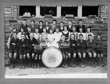
Photograph, State School No. 209. Dalton Street, Eltham, 1923
Back Row L-R: Garnet Burges, Keith Poulter, Jack McColl, Geoff Braithwaite, Pat Carrucan, Teddy (Alf) Harvey, Jack Carrucan, Jack Burgoyne Second Row L-R: Dorothy Butler, Dulcie Stone, Nell Leadbeater, Gwen Ryan, Gwen Butler, Maisie McColl, Mollie Russell, Phyllis West, Grace Braithwaite, Evie Bunker, Violet Fraser Front Row L-R: Jack Newton, Cyril Bowman, George Harrison, Fred Butterworth, Stan Ellis, Loftus Hancock, Harry Butherway, George Pitcher, Sid Castledine Cross Reference Photo No.(s): 641, 642, 672, 717This photo forms part of a collection of photographs gathered by the Shire of Eltham for their centenary project book,"Pioneers and Painters: 100 years of the Shire of Eltham" by Alan Marshall (1971). The collection of over 500 images is held in partnership between Eltham District Historical Society and Yarra Plenty Regional Library (Eltham Library) and is now formally known as the 'The Shire of Eltham Pioneers Photograph Collection.' It is significant in being the first community sourced collection representing the places and people of the Shire's first one hundred years.Digital image and 4 x 5 inch B&W Negsepp, shire of eltham pioneers photograph collection, eltham, dalton street, state school no. 209, cyril bowman, dorothy butler, dulcie stone, evie bunker, fred butterworth, garnet burges, geoff braithwaite, george harrison, george pitcher, grace braithwaite, gwen butler, gwen ryan, harry butherway, jack burgoyne, jack carrucan, jack mccoll, jack newton, keith poulter, loftus hancock, maisie mccoll, mollie russell, nell leadbeater, pat carrucan, phyllis west, sid castledine, stan ellis, teddy (alf) harvey, violet fraser -
 Eltham District Historical Society Inc
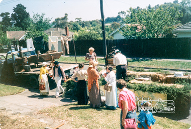
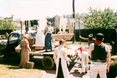
Photograph, Joh Ebeli, Setting up in Cecil Street, Eltham Festival Community Parade, 7 November 1987, 07/11/1987
[from a contemporary report:] Our float with its colonial washing day theme won the trophy for the best display. Bruce Ness arranged items from the Society's collection on his truck. Joh Ebeli and Russell Yeoman set up further items on the trailer loaned by Denis McKay. An important part of the event was the members who came along in their “old gear” to complete the picture. As usual musicians from the Victorian Folk Music Club helped us out with their lively music.Colour photographeltham festival, shire of eltham historical society, 1987, cecil street -
 Eltham District Historical Society Inc
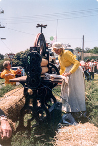
Photograph, Joh Ebeli, Flo Spicer, Eltham Festival Community Parade, 7 November 1987, 07/11/1987
[from a contemporary report:] Our float with its colonial washing day theme won the trophy for the best display. Bruce Ness arranged items from the Society's collection on his truck. Joh Ebeli and Russell Yeoman set up further items on the trailer loaned by Denis McKay. An important part of the event was the members who came along in their “old gear” to complete the picture. As usual musicians from the Victorian Folk Music Club helped us out with their lively music.Colour photographeltham festival, shire of eltham historical society, 1987, cecil street, flo spicer -
 Eltham District Historical Society Inc
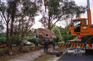
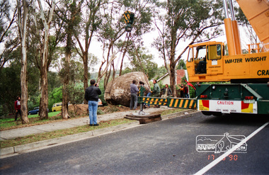
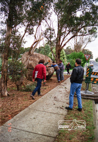
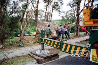
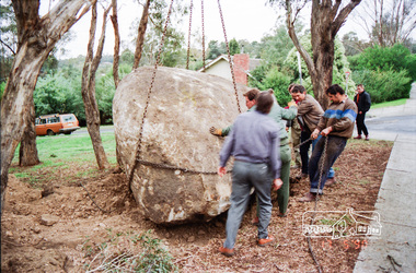
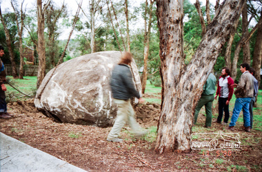
Photograph, Installation of commemorative rock for Walter Withers at corner of Bible and Arthur Streets, Eltham, 17 May 1990, 1990
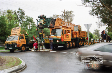
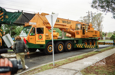
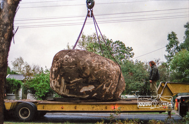
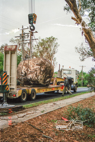
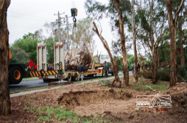
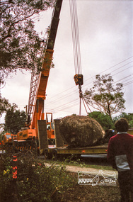
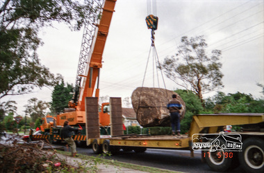
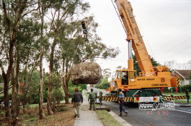
Roll of negatives of the installation of commemorative plaque and rock to Walter Withers installed in Walter Withers Reserve. Russell Yeoman advised (14 Jun 2017 society meeting) that the Shire of Eltham had been given a plaque to commemorate Walter Withers and that the rock was sourced from west of Melbourne with funds from a local government grant. The initial crane to lift the rock in place was too small and another crane was arranged. This also proved too small to lift it until a third and larger crane was arranged. Roll of 35mm colour negative film, 6 stripsFuji 100bible street, arthur street, eltham, walter withers reserve, walter withers rock -
 Eltham District Historical Society Inc
Photograph, Installation of commemorative rock for Walter Withers at corner of Bible and Arthur Streets, Eltham, 17 May 1990, 1990
Roll of negatives of the installation of commemorative plaque and rock to Walter Withers installed in Walter Withers Reserve. Russell Yeoman advised (14 Jun 2017 society meeting) that the Shire of Eltham had been given a plaque to commemorate Walter Withers and that the rock was sourced from west of Melbourne with funds from a local government grant. The initial crane to lift the rock in place was too small and another crane was arranged. This also proved too small to lift it until a third and larger crane was arranged. Roll of 35mm colour negative film, 6 stripsFuji 100bible street, arthur street, eltham, walter withers reserve, walter withers rock -
 Eltham District Historical Society Inc
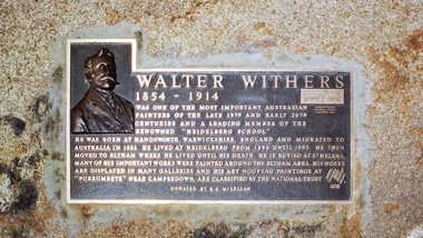
Photograph, Commemorative plaque mounted rock at corner of Bible and Arthur Streets, Eltham, donated by R.C. McLellan, Nov 1988
Russell Yeoman advised (14 Jun 2017 society meeting) that the Shire of Eltham had been given the plaque to commemorate Walter Withers and that the rock was sourced from west of Melbourne with funds from a local government grant. The initial crane to lift the rock in place was too small and another crane was arranged. This also proved too small to lift it until a third and larger crane was arranged and the rock was installed 17 May 1990.Roll of 35mm colour negative film, 2 stripsFuji 100arthur street, bible street, memorials, r.c. mclellan, walter withers, walter withers reserve, walter withers rock -
 Eltham District Historical Society Inc
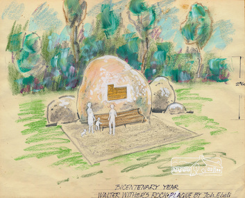
Sketch (Concept), Joh Ebeli, Bicentenary Year Walter Withers Rock and Plaque Design by Joh. Ebeli (1988), 1988
Concept sketch for the placement of a commemorative plaque on a rock in the Walter Wither Reserve at the corner of Arthur and Bible Streets, Eltham. The rock was installed 17 May 1990. Russell Yeoman advised (14 Jun 2017 society meeting) that the Shire of Eltham had been given a plaque to commemorate Walter Withers and that the rock was sourced from west of Melbourne with funds from a local government grant. The initial crane to lift the rock in place was too small and another crane was arranged. This also proved too small to lift it until a third and larger crane was arranged. Mary Owen, granddaughter of Walter Withers unveiled the commemorative plaque at a ceremony held at Walter Withers Reserve at the corner of Bible and Arthur Streets, Eltham, 13 Oct 1990.Colour pencil and wash on paper mounted on card and sealed at edges with masking tape. Protective facing sheet also attached with masking tape."Rock and Plaque design" on facing sheet On back: "John Ebeli 63 Batman Rd Eltham"eltham, walter withers reserve, walter withers rock, shire of eltham, arthur street, bible street, joh ebeli, design, plaques