Showing 520 items
matching small lake.
-
 Lakes Entrance Historical Society
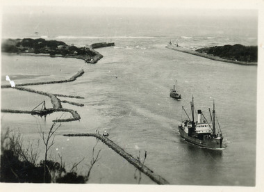
Photograph - SS Tambar, c1930
Also black and white copy 8 x 13Small format black and white photograph of SS Tambar heading inbound towards Nungurner. Another smaller vessel behind, rock groynes visible for formation of Bullock Island. Lakes Entrance Victoriaships and shipping, jetties, waterways -
 Lakes Entrance Historical Society
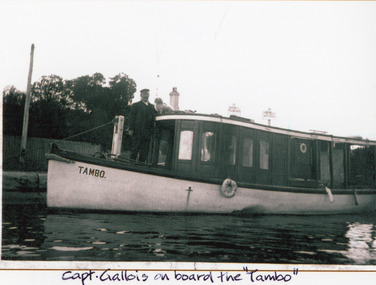
Photograph - SS Tambo, 1905
Black and white photograph showing P & H steam boat Tambo at the New Works, with Captain Gallois standing on the deck and small white dog on roof. Lakes Entrance, VictoriaCapt Gallois on board the 'Tambo'genealogy, historic ships -
 Lakes Entrance Historical Society
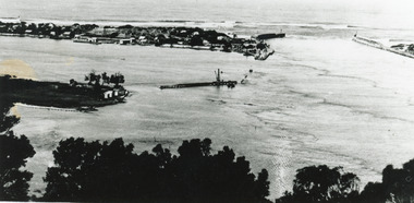
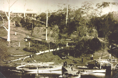
Postcard - The Entrance, Valentine Series, The Entrance to the Gippsland Lakes, 1895c
... to the Gippsland Lakes. It shows two small buildings on Bullock Island... Waterways Lakes Entrance from Jemmys Point Colour tinted postcard ...Also a Black and white copy 11.5 x 18Colour tinted postcard of the entrance from Bass Strait to the Gippsland Lakes. It shows two small buildings on Bullock Island, groyne from Bullock Island across Cunninghame arm, sand inside entrance at western pier. Lakes Entrance VictoriaLakes Entrance from Jemmys Pointislands, topography, waterways -
 Lakes Entrance Historical Society
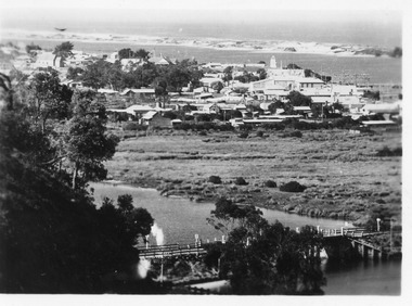
Postcard - North Arm bridge Lakes Entrance Victoria c1930, 1930c
Black and white small format postcard showing the town, North Arm bridge, Cunninghame Arm, sand hummocks, taken from Mt Barkly / Jemmys Point. Lakes Entrance Victoriabridges, township, coast, waterways -
 Lakes Entrance Historical Society
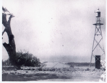
Photograph - Jemmys Point, 1925
Plus 1 x black and white small format photograph 6.5 x 6.5 taken from lookout, has signal light only|Plus 3 x small format postcards 6.5 x 8.5 taken from lookout, signal light quite distinct, with inscription Lookout Lakes EntranceBlack and white photograph of the entrance, taken from Jemmys Point between the old lookout tree and the signal light. Lakes Entrance Victoria coast, navigation, waterways -
 Lakes Entrance Historical Society
Book, Johnstone, Elsie, Our Little Town Growing up in Lakes Entrance by Elsie Johnstone, 2009
Twenty-eight stories from descendants of William Carstairs, founder of the Lakes Entrance, Victoria, fishing industry in the nineteenth century. These stories reflect everydayt life in this small town during the twentieth century.fishing industry, township, genealogy -
 Lakes Entrance Historical Society
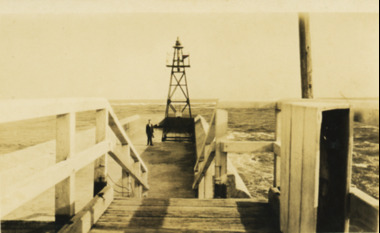
Photograph - Eastern Pier Lakes Entrance Victoria, 1920 c
Also a similar photograph showing section of eastern pier showing brick rocket shed far left and another small shed and board walk up to the flagstaff 05295.1 7 x 11.5 cmBlack and white photograph of end of eastern pier looking out to sea showing steps down from board walk onto concrete end of pier and green light beacon on end Lakes Entrance Victoriawaterways, piers -
Lakes Entrance Historical Society
Album, LERHS members, LERHS visit to Mallacoota, 2002 c
Small album of photographs taken during LERHS visit to Mallacoota plus those during Mallacoota Historical Society visit to Lakes Entrance Victoria East Gippslandvolunteering, community facilities -
Lakes Entrance Historical Society
Album, Lake Tyers Beach Tidy Town Committee, Tidy Towns, Lake Tyers Victoria, 1999 c
Taken by Lake Tyers Beach Tidy Town Committee members showing their efforts to tidy and beautify roadsides, parks and historical areas around Lake Tyers Beach Victoria. Visit the Historical Society to view the complete album. Small photographic album of colour photographs taken by Lake Tyers Beach Tidy Town Committee members showing their efforts to tidy and beautify roadsides, parks and historical areas around Lake Tyers Beach Victoriatidy town, groups -
 Lakes Entrance Historical Society
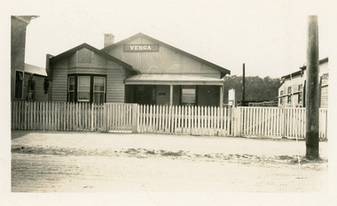
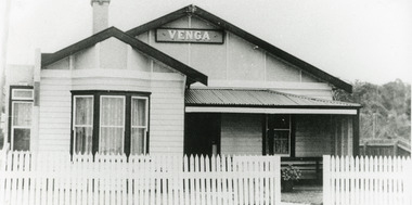
Photograph - Venga Guesthouse, 1928c
Francis cafe shop and guest house, burnt completely 1925-1926.Black and white photograph of Venga Guest House which was run for over thirty years by Miss Bertha Hansen. It shows a small weatherboard and cement sheet building, gable roof, bay window, half veranda at front. To west of Venga is side of Broomes Federal Hotel. To east is Cafe Francis. Lakes Entrance Victoria,guesthouses, architecture, restaurant -
 Lakes Entrance Historical Society
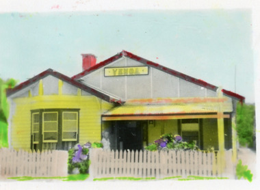
Photograph - Venga Guesthouse, 1940c
Hand coloured small format photograph of Venga Guest House. It shows a timber and cement sheet building, gable roof, bay window, half veranda across front, flowering hydrangeas behind picket fence. Lakes Entrance Victoria.guesthouses, historic buildings -
 Lakes Entrance Historical Society
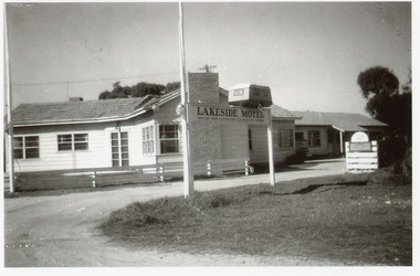
Photograph - Lakeside Motel, Willis, Barbara, 1951c
Original photo taken during honeymoon of Ron and Barbara Willis 1951Black and white photograph of the entry to Lakeside Motel, Marine Parade. View shows cottage style units clad in weatherboard with tiled roofs. Sign at entry has small model of a caravan, advertising caravan sites. Lakes Entrance Victoriamotels, advertising -
 Lakes Entrance Historical Society
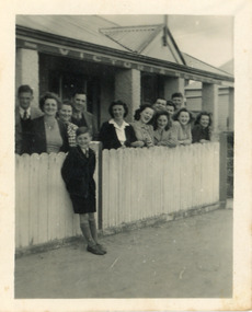
Photograph - Victoria House, 1945c
Also larger copy 01236.1Black and white photograph of the front of Victoria House. It shows a group of twelve people behind a white picket fence, small boy leaning on front of fence. Lakes Entrance VictoriaVictoria House on verandaguesthouses, tourism, fences, people -
 Lakes Entrance Historical Society
Postcard - Venga Guesthouse, Bulmer H D, 1940c
Black and white photo of Venga Guest House, Lakes Entrance, Victoria, showing front of guest house with signage, fenced garden, small veranda over front door, front bay window, side lane.Miss B M Hansen's Guest Houseguesthouses, architecture, fences -
 Lakes Entrance Historical Society
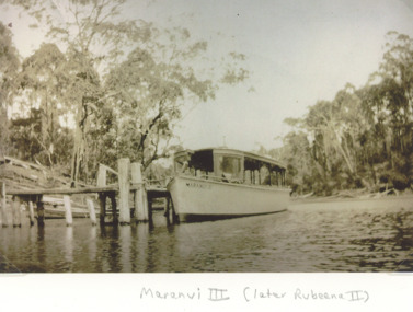
Photograph, boat Maranui III , Toorloo Arm Lake Tyers Victoria, 1930 c
Maranui III built 1918 c in service on Yarra until 1926 then became part of Bills small fleet of tourist launches until December 1931, renamed Rubeena II by Coate BrothersSepia toned photograph of Bills tourist launch Maranui III on Toorloo Arm Lake Tyers Victoriaboats and boating, tourism -
 Lakes Entrance Historical Society
Photograph, Toorloo Arm House Lake Tyers Victoria, 1930 c
and large boat Alice Ray and small boat Tamar in foreground on Toorloo ArmSepia toned photograph of view of Bills Toorloo Arm House on hill in background Lake Tyers Victoria. Also another black and white photograph of similar view with same boats on wateraccommodation, guesthouses, boats and boating -
 Lakes Entrance Historical Society
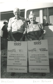
Photograph, Lakes Post Newspaper, Tidy Town Committee Lake Tyers Beach Victoria
Southeast and State award in litter control. . In the second photo presenting award for 1995 Tidy TownBlack and white photograph of Doug Coole and Edith Juillerat Tidy Town Committee Lake Tyers Beach Victoria. Also a small black and white photograph of Doug Coole and Cr Frank Hunter environment, awards -
 Lakes Entrance Historical Society
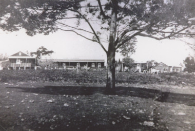
Photograph, Toorloo House guesthouse Lake Tyers Victoria, 1935 c
Large house on right has been demolished small detached building on left remains Lake Tyers Victoria.Black and white photograph of Toorloo House guesthouse at Bills Arm owned by Bills family. Also two similar black and white photographs of Toorloo House topography, guesthouses -
 Lakes Entrance Historical Society
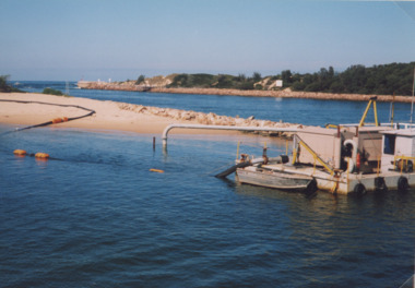
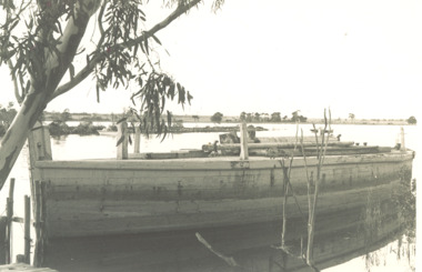
Photograph, small dredge Lakes Entrance Victoria, 1/04/1999 12:00:00 AM
... Forests and Land, small dredge Lakes Entrance Victoria Photograph ...Colour photograph of small dredge and pipeline from dredge across sand beside entrance at launch of six month trial of sand transfer pumping system at New Works area Lakes Entrance Victoria. Plus two other photos including Barrie Martin of Gippsland Ports, Marie Tehan Minister for Conservation Forests and Land, environment, waterfront -
 Lakes Entrance Historical Society
Photograph - President of Nowa Nowa Hall Committee, Lakes Post Newspaper, 1/01/1993 12:00:00 AM
Small black and white photograph of Veronica Brooks, President of Nowa Nowa Hall Committee who accepted award for Event of the Year, King of the Mountain Nungurner Victoriacelebrations, awards, genealogy -
 Lakes Entrance Historical Society
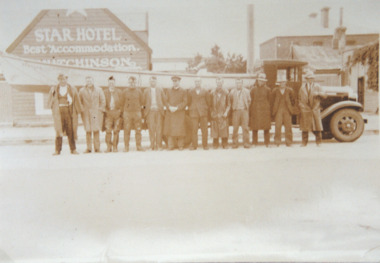
Photograph, H D Bulmer, Lakes Entrance fisherman rescue during 1934 floods near Sale, 1934 c
Lakes Entrance fishermen travelled to the Sale area to assist in the rescue of flood victims during 1930sSepia toned photograph of Lakes Entrance fishermen standing beside a boat on the tray of a small truck outside the Star Hotel Sale Victoriaships and shipping, floods, natural disasters -
 Lakes Entrance Historical Society
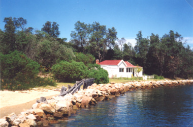
Photograph, Judy Davies, Schnapper Cottage at Lakes Entrance Victoria, March 2001
Colour photograph of Schnapper Cottage a small white painted dwelling with a red roof situated on the edge of lake edged with rock groyne and remains of timber railing at western side of entrance at Lakes Entrance Victoria.Also two photographs taken inside Schnappers Cottage showing tongue and groove lining, coved ceiling, dado above wide vertical wall boardsgippsland lakes, settlement, houses -
 Lakes Entrance Historical Society
Photograph, Lady Harriet Barge, Lakes EntranceVictoria, 1988
Photograph taken after barge was purchased from Elliott family before being towed to Lakes Entrance for Entrance Centenary celebrations. , small jetty bottom left hand corner, Silt jetties with Jones Bay in distance limb of gum tree could be on the Mitchell River near Bairnsdale Gippsland Lakes VictoriaBlack and white photograph of Lady Harriets barge moored with mast removed and lying on deck, small jetty bottom left hand corner, Silt jetties with Jones Bay in distance limb of gum tree overhanging top left corner could be on the Mitchell River near Bairnsdale Gippsland Lakes Victoriabusinesses, barges, boats and boating -
 Lakes Entrance Historical Society
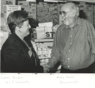
Photograph - Lynne Roder1996, Lakes Post Newspaper, 1/03/1996 12:00:00 AM
discussing the needs of small business with Kerry Harry Pharmacist of Myer Street Lakes Entrance VictoriaBlack and white photograph showing Lynne Roder ALP candidate discussing the needs of small business with Kerry Harry Pharmacist of Myer Street Lakes Entrance Victoriapolitics, businesses -
 Lakes Entrance Historical Society
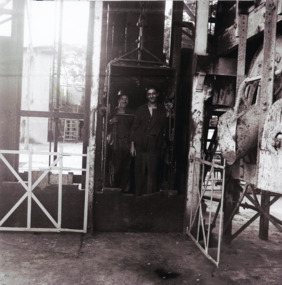
Photograph - Oil industry, H D Bulmer, 1945
Also black and white photograph showing workmen seated in a small open cabin which appears to be a control centre for working part of the machinery at the deep shaft oil well 05321 .1 16.5 x 16.5Black and white photograph showing two workmen standing in the liftcage prepared to descend to the deep shaft oil well at Lakes Entrance Victoriamachinery, oil and gas industry -
 Lakes Entrance Historical Society
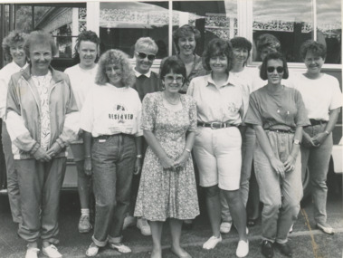
Photograph, Lakes Post Newspaper, Carpenters Tours Lakes Entrance Victoeia. c1990, 1990 c
Mike and Una Carpenter had a bus initially to take their campers to places of interest soon growing into the business Carpenters Out and About toursBlack and white photograph showing Una Carpenter with holiday makers standing beside small passenger bus at Carpenters Camp Park Lakes Entrance Victoriacaravan parks, tourism, vehicles, social history -
 Arapiles Historical Society
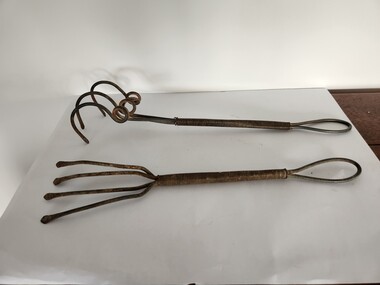
Tool - Roy SCHMIDT Collection - Handmade Garden Forks (2)
These hand tools are examples of early to mid-20th century garden cultivators, designed for home gardening, small-scale agriculture, or kitchen gardens. Their full-metal construction suggests they were built for durability and could be used in tough soils where wooden-handled tools might break. The minimalist yet practical design would have made them ideal for weeding, soil aeration, or root work in garden beds. Such tools were commonly found in household sheds and were often homemade or locally manufactured by blacksmiths or rural toolmakers. – Roy SCHMIDT resided with his siblings Mabel and Jack at ‘Parklands’ 85 Lake Avenue Natimuk home of Heinrich Friederick ‘Heiny’ & Minna Christina SUDHOLZ nee LANGE and their children Louis, Sophie, Alma, Lena (Roy's Mother), Florence 'Florrie' and Edward ‘Ted’.The image shows two vintage hand garden forks or cultivators, each constructed entirely from metal, including coiled wire handles. The implements are similar in size and style, but differ in tine configuration: [1] Handmade Garden Fork Straight Prongs: Has five straight, flatter tines, more like a rake, and is better suited for fine cultivation, weeding, or breaking up soil clods. [2] Handmade Garden Fork Claw Prongs: Features three thick, curved tines arranged in a spiral and claw-like fashion. These tines are more widely spaced and likely used for loosening tough or compacted soil, or for aerating.gardening -
 Lakes Entrance Historical Society
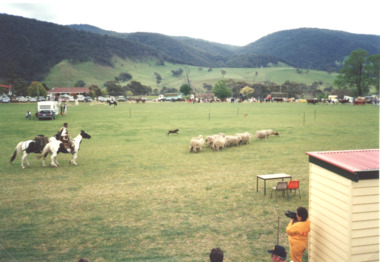
Photograph - Agricultural Show Omeo Victoria, Lakes Post Newspaper, 1993
Colour photograph of Conndly on his horse with packhorse two working dogs and small mob of sheep demonstrating the dogs skills at the Agricultural Show Omeo Victoria 1993. Also two colour photographs of models wearing wool fashions on Doolans truck tray,fires, township -
 Lakes Entrance Historical Society
Album, Vera Bennett, Johnsonville School becomes Lakes Entrance Regional Historical Society Lakes Entrance Victoria, 2004 c
A small album with photographs showing the transformation of Johnsonville School to become Lakes Entrance Regional Historical Society Lakes Entrance Victoria. Please visit History Centre to view full albumhistoric sites, schools, land development -
 Lakes Entrance Historical Society
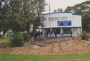
Photograph - Visitors Information Centre, Lakes Entrance Victoria, E G Newspaper, 1/10/2014 12:00:00 AM
newly extended Visitors Information Centre, small crowd gathered for official opening, Lakes Entrance VictoriaColour photograph showing newly extended Visitors Information Centre, small crowd gathered for official opening, Lakes Entrance Victoriatourism, buildings