Showing 3153 items
matching south west
-
 Glenelg Shire Council Cultural Collection
Photograph - Photograph - aerial view of Portland, c. 1954
... south west coastline... central Portland Portland Harbour south west coastline Front: '607 ...Black and white aerial photograph of coastline around Portland. Black border, scale all sides, 5 rows of 3 't' at regular intervals. Bottom half ocean, top half land, separated by beach, further left than 8471Front: '607 - 90 ' - handwritten, white, borderaerial photography, central portland, portland harbour, south west coastline -
Glenelg Shire Council Cultural Collection
Photograph - Photograph - aerial view of Portland, c. 1954
... south west coastline... central Portland Portland Harbour south west coastline Front: '607 ...Black and white aerial photograph of coastline around Portland. Black border, scale all sides, 5 rows of 3 't' at regular intervals.Front: '607 -104' - handwritten, white, lower border 'RUN 5' 'PORTLAND', printed, white, lower borderaerial photography, central portland, portland harbour, south west coastline -
Glenelg Shire Council Cultural Collection
Photograph - Photograph - aerial view of Portland, c. 1954
... south west coastline... central Portland Portland Harbour south west coastline Front: '820 ...Black and white aerial photograph of coastline around Portland. Black border, scale all sides, 5 rows of 3 't' at regular intervals. Fifty percent ocean, 50 percent land. See 'Other Information'Front: '820 -49' - handwritten, white, lower border 'RUN 6' 'PORTLAND', printed, white, lower borderaerial photography, central portland, portland harbour, south west coastline -
Glenelg Shire Council Cultural Collection
Photograph - Photograph - aerial view of Portland, c. 1954
... south west coastline... central Portland Portland Harbour south west coastline Front: '607 ...Black and white aerial photograph of coastline around Portland. Black border, scale all sides, 5 rows of 3 't' at regular intervals. Mostly landFront: '607 - 53 ' - handwritten, white, border 'RUN 7 ' 'PORTLAND', printed, white, borderaerial photography, central portland, portland harbour, south west coastline -
Glenelg Shire Council Cultural Collection
Photograph - Photograph - aerial view of Portland, c. 1954
... south west coastline... central Portland Portland Harbour south west coastline Front: '820 ...Black and white aerial photograph of coastline around Portland. Black border, scale all sides, 5 rows of 3 't' at regular intervals. 20% ocean, 80% land.Front: '820 -51' - handwritten, white, border 'RUN 6' 'PORTLAND', printed, white, borderaerial photography, central portland, portland harbour, south west coastline -
Glenelg Shire Council Cultural Collection
Photograph - Photograph - aerial view of Portland, c. 1954
... south west coastline... central Portland Portland Harbour south west coastline Front: '607 ...Black and white aerial photograph of coastline around Portland. Black border, scale all sides, 5 rows of 3 't' at regular intervals. Mostly ocean, small area of land, top centreFront: '607 - 50 ' - handwritten, white, border 'RUN 8' 'PORTLAND', printed, white, borderaerial photography, central portland, portland harbour, south west coastline -
Glenelg Shire Council Cultural Collection
Photograph - Photograph - aerial view of Portland, c. 1954
... south west coastline... central Portland Portland Harbour south west coastline Front: '784 ...Black and white aerial photograph of coastline around Portland. Black border, scale all sides, 5 rows of 3 't' at regular intervals. Right hand end of headland no longer visible. 50/50 ocean to land.Front: '784 - 151'- handwritten, white, border 'RUN A PORTLAND', printed, white, borderaerial photography, central portland, portland harbour, south west coastline -
Glenelg Shire Council Cultural Collection
Photograph - Photograph - aerial view of Portland, c. 1954
... south west coastline... central Portland Portland Harbour south west coastline Front: '607 ...Black and white aerial photograph of coastline around Portland. Black border, scale all sides, 5 rows of 3 't' at regular intervals.Front: '607 -103' -- handwritten, white, lower border 'RUN 5' 'PORTLAND', printed, white, lower borderaerial photography, central portland, portland harbour, south west coastline -
Glenelg Shire Council Cultural Collection
Photograph - Photograph - aerial view of Portland, c. 1954
... south west coastline... central Portland Portland Harbour south west coastline Front: '820 ...Black and white aerial photograph of coastline around Portland. Black border, scale all sides, 5 rows of 3 't' at regular intervals. Three quarters ocean, one quarter land. See Other InformationFront: '820 -48' - handwritten, white, border 'RUN 6' 'PORTLAND', printed, white, borderaerial photography, central portland, portland harbour, south west coastline -
Glenelg Shire Council Cultural Collection
Photograph - Photograph - aerial view of Portland, c. 1954
... south west coastline... central Portland Portland Harbour south west coastline Front: '607 ...Black and white aerial photograph of coastline around Portland. Black border, scale all sides, 5 rows of 3 't' at regular intervals. Bottom third is ocean, the rest is land, separated by beach.Front: '607 - 89 ' - handwritten, white, border 'RUN - 6 PORTLAND', printed, white, borderaerial photography, central portland, portland harbour, south west coastline -
Glenelg Shire Council Cultural Collection
Photograph - Photograph - aerial view of Portland, c. 1954
... south west coastline... central Portland Portland Harbour south west coastline Front: '784 ...Black and white aerial photograph of coastline around Portland. Black border, scale all sides, 5 rows of 3 't' at regular intervals. Both sides of headland can be seen. 60/40 ocean to landFront: '784 - 150 - handwritten, white, border 'RUN 7 A PORTLAND', printed, white, borderaerial photography, central portland, portland harbour, south west coastline -
Glenelg Shire Council Cultural Collection
Negative - Negative - Nun's Beach, Portland, c. 1934
... south west coastline... Cliff Street Portland great-ocean-road negative south west ...NEGATIVE FOR BLACK AND WHITE PHOTOGRAPH. View taken from Nun's Beach looking towards Whaler's Bluff.negative, south west coastline, portland, nuns beach -
Glenelg Shire Council Cultural Collection
Photograph - Photograph - aerial view of Portland, c. 1954
... south west coastline... central Portland Portland Harbour south west coastline Front: '784 ...Black and white aerial photograph of coastline around Portland. Black border, scale all sides, 5 rows of 3 't' at regular intervals. Another curve in land, away from ocean. 70/30 ocean to landFront: '784 - 153' - handwritten, white, border 'RUN 7 A PORTLAND', printed, white, borderaerial photography, central portland, portland harbour, south west coastline -
Glenelg Shire Council Cultural Collection
Photograph - Photograph - Cape Bridgewater, n.d
... south west coastline... formation cliffs south west coastline coastline Back: 'Rough sea ...Black and white photo - of rough seas breaking on rocks at foot of cliffs, Cape Bridgewater. Two ladies standing on top of cliff, left of photoBack: 'Rough sea - Cape Bridgewater' - handwritten, black ink. '7' - pencilcape bridgewater, rock formation, cliffs, south west coastline, coastline -
Glenelg Shire Council Cultural Collection
Photograph - Photograph - aerial view of Portland, c. 1954
... south west coastline... central Portland Portland Harbour south west coastline Front: '607 ...Black and white aerial photograph of coastline around Portland. Black border, scale all sides, 5 rows of 3 't' at regular intervals. Buildings visible bottom leftFront: '607 -106' -- handwritten, white, lower border 'RUN 5' 'PORTLAND', printed, white, lower borderaerial photography, central portland, portland harbour, south west coastline -
Glenelg Shire Council Cultural Collection
Photograph - Photograph - aerial view of Portland, c. 1954
... south west coastline... central Portland Portland Harbour south west coastline Front: '607 ...Black and white aerial photograph of coastline around Portland. Black border, scale all sides, 5 rows of 3 't' at regular intervals. Bottom half ocean, top land, separated by beach.Front: '607 - 92 ' - handwritten, white, border 'RUN - 6 PORTLAND', printed, white, borderaerial photography, central portland, portland harbour, south west coastline -
Glenelg Shire Council Cultural Collection
Photograph - Photograph - aerial view of Portland, c. 1954
... south west coastline... central Portland Portland Harbour south west coastline Front: '607 ...Black and white aerial photograph of coastline around Portland. Black border, scale all sides, 5 rows of 3 't' at regular intervals. Small strip of land across bottom. The rest is ocean.Front: '607 - 56 ' - handwritten, white, border 'RUN 7 PORTLAND', printed, white, borderaerial photography, central portland, portland harbour, south west coastline -
Glenelg Shire Council Cultural Collection
Photograph - Photograph - aerial view of Portland, c. 1954
... south west coastline... central Portland Portland Harbour south west coastline Front: '784 ...Black and white aerial photograph of coastline around Portland. Black border, scale all sides, 5 rows of 3 't' at regular intervals. Start of headland, 80/20 ocean to landFront: '784 - 149' - handwritten, white, border 'RUN 7 A PORTLAND', printed, white, borderaerial photography, central portland, portland harbour, south west coastline -
 Flagstaff Hill Maritime Museum and Village
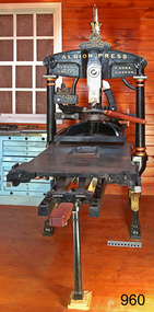
Equipment - Printing Press, Harrild and Sons, 1866
... south west victoria newspapers... newspaper south west victoria newspapers harrild and sons london ...This Albion printing press was manufactured by Harrild & Sons of London and exported in 1868 from London to the colonial Western Victoria town of Coleraine, population of 700 at that time. It was installed in the Colerain Albion printing office. It was used to print the first edition of the Coleraine Albion newspaper in 1868 and continued until publication ceased in 1974. The Albion Press is still being used today by a volunteer printer in the “Examiners Office” in the village at Flagstaff Hill. Amongst the items produced are printed paper bags for the Tea Rooms and posters for visitors. ALBION PRINTING PRESS The Albion press was invented and manufactured in London by Richard Whittaker Cope around 1820 and was still being produced in the 1930s. The Albion was manufactured under licence by several companies from the 1850s onwards, one of which was Harrild & Sons of Fleet Works, London. Harrild & Sons describes its business as “printing materials manufacturer”. The business was established in 1807 by Robert Harrild and named R. Harrild & Co. In 1813 he showed that rollers could be used to ink a printing plate instead of inking balls, the method in use at the time. He then established a company to make the rollers. Eventually his company would make other printing materials and equipment. Robert’s sons joined him in the 1830s, when the company was renamed Harrild & Sons, and they continued to run the company after his death in 1853 and up until the mid-1900s. COLERAINE ALBION PRINTING OFFICE The Coleraine Albion Printing Office was established by W.L. Ambler. The first issue of the Coleraine Albion was dated 4th January 1868. Arrangements had been made to receive news from Melbourne, nearby provinces, other colonies and England. The second issue on 18 January 1868 printed articles from many agencies, including the Melbourne Age and the Warrnambool Examiner. The Albion office was sold to William Hatherleigh, formerly of Portland, in October 1868. Thereafter the Albion office had many owners. The last was L. A. & E. Oliver, who took over in January 1972 and was the last to be stated as printers and publishers of the Coleraine Albion. The office was wound up in 1974. The Albion Press and other equipment was distributed to Star printing in Terang. Star Printing donated the Albion press to Flagstaff Hill Maritime Village around 1980 and Stan Philp, owner of Philprint in Warrnambool, transported it to Warrnambool, brought it up to good working order and organised the supply of appropriate printer’s type. The Albion hand operated printing press is significant for producing the first newspaper in Coleraine, Western Victoria and continuing production for over 100 years. The Albion is technologically significant as a working example of a hand operated printer from the mid-19th century. The use of the printer is demonstrated by volunteers at Flagstaff Hill, printing items such as lolly and treat bays for use in the Village. The Albion is socially significant for its role in the isolated provincial colony, providing communication with the outside world, both in Australia and overseas. Newspaper printers were often amongst the first businesses of a small town. Printing press; hand operated Albion Press, Patent 2105. The machine has an upright iron frame at the back that supports the upper press that has a wooden handled metal bar is attached. The frame and legs support a thick metal flatbed. A metal leg supports the front of the press bed. The iron work is painted black with gold highlights. The decorative legs are finished with the golden feet of an animal. The frame above the metal bed includes a crown shaped finial symbol above the maker’s emblem. The maker’s details and the name of the printer are embossed on the upright frame. A plaque with the patent number is below a Lion and Unicorn emblem.Embossed maker’s emblem [A red cross - above a double ring – square inside ring – three banners below ring]. - Inside the double rings “PRINTING MATERIALS MANUFACTURE” - Inside the square, intertwined text “H & S” [representing Harrild & Sons] - Inside the three banners ““FLEET” “WORKS.” “LONDON.E.C.” Embossed across the shoulders “ALBION PRESS / HARRILD & SONS, / MAKERS LONDON.” Emblem above plaque [Lion and Unicorn] Embossed on the plaque “PATENT / 2105” Stamped into upright machine part above the printing bed “2105 / 1866” flagstaff hill, warrnambool, shipwrecked coast, flagstaff hill maritime museum, maritime museum, shipwreck coast, flagstaff hill maritime village, albion press, printing press, 1866 printing press, printing equipment, communications, coleraine albion printing office, coleraine newspaper, albion newspaper, south west victoria newspapers, harrild and sons london, richard whittaker cope, star printing terang, philprint, coleraine albion, hand operated press -
 Flagstaff Hill Maritime Museum and Village
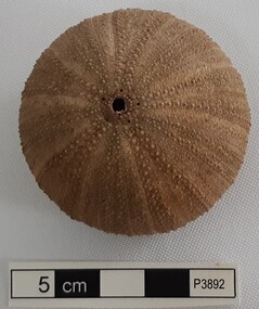
Animal specimen - Sea Urchin
... south west victoria... sea urchin south west victoria sea life Sea urchin, global ...This sea urchin shell was recovered from the wreck of the S.S. Casino (1882 – 1932) between the late 1960’s to early 1970’s. It is part of the John Chance Collection. The coastal trader SS Casino (1882–1932) had a run of almost 50 years along the coast of Western Victoria. She traded goods and food as well as carrying passengers from port to port on her many voyages. This vase may have been included in her cargo or could have been amongst the personal luggage of the people on board.The sea urchin shell is significant as an example of underwater animal life existing in Victoria the 1960s. It was recovered by John Chance, a diver from the wreck of the S.S. Casino in the 1960s-70s. Items that come from several wrecks along Victoria's coast have since been donated to the Flagstaff Hill Maritime Village’s museum collection by his family, illustrating this item’s level of historical value. The urchin is connected with the S.S. Casino, which played an historical role in Western Victoria, providing transport, communication and trade along the coast between Melbourne and Portland in the late 19th and the early 20th century, visiting the ports at Apollo Bay, Warrnambool and Belfast (Port Fairy). The S.S. Casino was the only regular trader with normal passenger accommodation along the West Coast and the only Western District steamship that was in service between 1854 and 1939, and to be represented in the Victorian Heritage Shipwreck register, and to have been wrecked in the Western District, and to have the wreck located, and to be accessible to divers. The wreck of the S.S. Casino, and its associated relics, is considered an important part of Victorian and Australian cultural heritage and is now protected as a Historic Shipwreck under State and Commonwealth Law in the Commonwealth Historic Shipwrecks Act (1976). Sea urchin, global shape, beige colour. Urchin has two naturally formed holes, the larger being the mouth. Ten segments radiate from top to bottom, each with a row of small white raised circles.flagstaff hill, warrnambool, flagstaff hill maritime museum, maritime museum, shipwreck coast, flagstaff hill maritime village, great ocean road, s.s. casino, john chance, west coast trader, apollo bay, sea urchin, south west victoria, sea life -
 Monbulk RSL Sub Branch
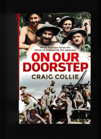
Book, Allen & Unwin, On our doorstep : when Australia faced the threat of invasion by the Japanese, 2020
... World war 1939 – 1945 – Campaigns – South West Pacific...-and-the-dandenong-ranges World war 1939 – 1945 – Campaigns – South West ...By March 1942, the Japanese had steamrolled through Malaya, laid siege to Singapore, and bombed Darwin with the same ferocity they had dealt Pearl Harbor. Nothing could stop them. Their next step was inevitable, surely: the invasion and occupation of Australia. Meanwhile, as Australian prime minister John Curtin was battling with Winston Churchill to get troops back from overseas to defend their homeland, he was also positioning to ensure the United States would be there with us to fend off the approaching enemy. And at home, people pitched in as best they could and in any way to frustrate the invader. They all played their part, torn between 'she'll be right' and near panic. On Our Doorstep is the story of how Australia and Australians - the government, the military and the people - prepared to face this calamity, and the events that persuaded them of its probability. In the end, Japan found it had stretched itself beyond the reliability of its supply line, but had it ever intended to invade Australia?Index, bibliography, notes, ill, map, p.404.non-fictionBy March 1942, the Japanese had steamrolled through Malaya, laid siege to Singapore, and bombed Darwin with the same ferocity they had dealt Pearl Harbor. Nothing could stop them. Their next step was inevitable, surely: the invasion and occupation of Australia. Meanwhile, as Australian prime minister John Curtin was battling with Winston Churchill to get troops back from overseas to defend their homeland, he was also positioning to ensure the United States would be there with us to fend off the approaching enemy. And at home, people pitched in as best they could and in any way to frustrate the invader. They all played their part, torn between 'she'll be right' and near panic. On Our Doorstep is the story of how Australia and Australians - the government, the military and the people - prepared to face this calamity, and the events that persuaded them of its probability. In the end, Japan found it had stretched itself beyond the reliability of its supply line, but had it ever intended to invade Australia?world war 1939 – 1945 – campaigns – south west pacific, australia - politics and government - 1939-1945 -
 Monbulk RSL Sub Branch
Book, Rigby, War correspondent, 1964
... Campaigns - South West Pacific theatre... – Australia Campaigns - South West Pacific theatre Frank Legg ...Frank Legg was a war correspondent accompanying the Australian forces in the South Pacific area during World War TwoIll, p.265.non-fictionFrank Legg was a war correspondent accompanying the Australian forces in the South Pacific area during World War Twoworld war 1939 – 1945 – personal narratives – australia, campaigns - south west pacific theatre -
 Monbulk RSL Sub Branch
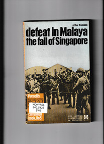
Book, Pan Books, Defeat in Malaya: The fall of Singapore, 1969
... world war 1939-1945 - campaigns - south west pacific... 1939-1945 - campaigns - south west pacific The invasion ...The invasion of Malaya and Singapore by Japan in 1941Ill, maps, p.159.non-fictionThe invasion of Malaya and Singapore by Japan in 1941world war 1939-1945 - campaigns - malaya, world war 1939-1945 - campaigns - south west pacific -
 Monbulk RSL Sub Branch
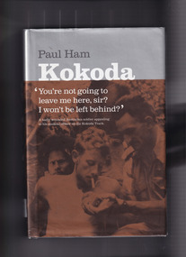
Book, Paul Ham, Kokoda, 2004
... World War 1939-1945 - Campaigns - South West Pacific... War 1939-1945 - Campaigns - South West Pacific For the first ...For the first time ever, the compelling story of the infamous Kokoda Track campaign has been told from both sides of the conflict. In a unique and balanced portrayal, renowned journalist Paul Ham recounts both the Australian and Japanese perspectives of the events on the hellish Papuan jungle trail where thousands fought and died during World War II. Based on extensive research in Australia and Japan, and including previously unpublished documents, Kokoda intimately relates the stories of ordinary soldiers in 'the world's worst killing field', and examines the role of commanders in sending ill-equipped, unqualified Australian troops into battles that resulted in near 100 per cent casualty rates. It was a war without mercy, fought back and forth along 90 miles (145 km) of river crossings, steep inclines and precipitous descents, with both sides wracked by hunger and disease, and terrified of falling into enemy hands. Defeat was unthinkable: the Australian soldier was fighting for his homeland against an unyielding aggressor; the Japanese ordered to fight to the death in a bid to conquer 'Greater East AsiaIndex, bib, ill, p.602.non-fictionFor the first time ever, the compelling story of the infamous Kokoda Track campaign has been told from both sides of the conflict. In a unique and balanced portrayal, renowned journalist Paul Ham recounts both the Australian and Japanese perspectives of the events on the hellish Papuan jungle trail where thousands fought and died during World War II. Based on extensive research in Australia and Japan, and including previously unpublished documents, Kokoda intimately relates the stories of ordinary soldiers in 'the world's worst killing field', and examines the role of commanders in sending ill-equipped, unqualified Australian troops into battles that resulted in near 100 per cent casualty rates. It was a war without mercy, fought back and forth along 90 miles (145 km) of river crossings, steep inclines and precipitous descents, with both sides wracked by hunger and disease, and terrified of falling into enemy hands. Defeat was unthinkable: the Australian soldier was fighting for his homeland against an unyielding aggressor; the Japanese ordered to fight to the death in a bid to conquer 'Greater East Asiaworld war 1939 – 1945 – campaigns – kokoda, world war 1939-1945 - campaigns - south west pacific -
 Victorian Aboriginal Corporation for Languages
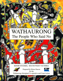
Book, Bruce Pascoe et al, Wathaurong : the people who said no, 2003
... South West Victoria... Bay Western Port Bay Lorne South West Victoria Battle Creek ...The Wathaurong people of South Western Victoria said no to European invasion. Learn about this heroic resistance to the occupation of their lands. Can white and black live together or must we be always at war? The answer can only be given by young Australians. Includes a comprehensive historical timeline.maps, colour illustrations, b&w illustrations, colour photographs, word listswathaurong, wadtharung, port philllip bay, western port bay, lorne, south west victoria, battle creek, aire river, werribee, ballarat, wathaurong aboriginal cooperative, coast action, koori studies, john batman, william buckley, aboriginal studies policy, secondary school education, hissing swan, victorian history -
Koorie Heritage Trust
Book, Beauglehole, A. C, The distribution and conservation of vascular plants in the Corangamite-Otway area, Victoria, 1980
... Indigenous vascular plants. Distribution. South-west.... Distribution. South-west Victoria. | Botany -- Victoria. ii,108p. : ill ...ii,108p. : ill. ; 21x30cm. + 1 col.fold.map in pocket.indigenous vascular plants. distribution. south-west victoria. | botany -- victoria. -
 National Wool Museum
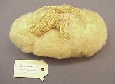
Sample, Wool
... South West College of TAFE - Textiles Department... TAFE College. Handicrafts South West College of TAFE - Textiles ...Wool was made in dyeing workshop at Warrnambool TAFE College.DAHLIA PETALSI/ALUM Dahlia petals/ 1st batchhandicrafts, south west college of tafe - textiles department, dyeing -
 National Wool Museum
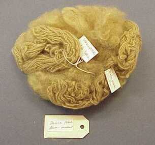
Sample, Wool
... South West College of TAFE - Textiles Department... TAFE College. (unconfirmed) Handicrafts South West College ...Wool was dyed in dyeing workshop at Warrnambool TAFE College. (unconfirmed)Gum Leaves /Alum mordanthandicrafts, south west college of tafe - textiles department, dyeing -
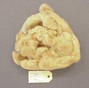 National Wool Museum
Sample, Wool
... South West College of TAFE - Textiles Department... TAFE College. (unconfirmed) Handicrafts South West College ...Wool was dyed in dyeing workshop at Warrnambool TAFE College. (unconfirmed)Geranium petals/Red flowers/Alum-mordanthandicrafts, south west college of tafe - textiles department, dyeing -
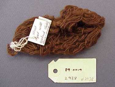 National Wool Museum
Sample, Wool
... South West College of TAFE - Textiles Department... TAFE College. (unconfirmed) Handicrafts South West College ...Wool was dyed in dyeing workshop at Warrnambool TAFE College. (unconfirmed)Wool dyed with walnut shells / Alum -mordant Walnut shells / Alum -mordanthandicrafts, south west college of tafe - textiles department, dyeing