Showing 663 items
matching state issue
-
 Kew Historical Society Inc
Plan, Melbourne & Metropolitan Board of Works : Borough of Kew : Detail Plan No.1565, 1905
The Melbourne and Metropolitan Board of Works (MMBW) plans were produced from the 1890s to the 1950s. They were crucial to the design and development of Melbourne's sewerage and drainage system. The plans, at a scale of 40 feet to 1 inch (1:480), provide a detailed historical record of Melbourne streetscapes and environmental features. Each plan covers one or two street blocks (roughly six streets), showing details of buildings, including garden layouts and ownership boundaries, and features such as laneways, drains, bridges, parks, municipal boundaries and other prominent landmarks as they existed at the time each plan was produced. (Source: State Library of Victoria). This plan forms part of a large group of MMBW plans and maps that was donated to the Society by the Mr Poulter, City Engineer of the City of Kew in 1989. Within this collection, thirty-five hand-coloured plans, backed with linen, are of statewide significance as they include annotations that provide details of construction materials used in buildings in the first decade of the 20th century as well as additional information about land ownership and usage. The copies in the Public Record Office Victoria and the State Library of Victoria are monochrome versions which do not denote building materials so that the maps in this collection are invaluable and unique tools for researchers and heritage consultants. A number of the plans are not held in the collection of the State Library of Victoria so they have the additional attribute of rarity.Original survey plan, issued by the MMBW to a contractor with responsibility for constructing sewers in the area identified on the plan within the Borough of Kew. The plan was at some stage hand-coloured, possibly by the contractor, but more likely by officers working in the Engineering Department of the Borough and later Town, then City of Kew. The hand-coloured sections of buildings on the plan were used to denote masonry or brick constructions (pink), weatherboard constructions (yellow), and public buildings (grey). MMBW Plan No.1565 is an example of a plan where a number of streets have been created since the area was surveyed, or in other cases renamed. The plan shows those streets that were bordered by Ross Street, Mount Street, Sackville Street and Burke Road. Since 1905, Mawson Street has been created and Mont Albert Road renamed as Dean Street. Named houses on the plan include ‘Tyrol’, ‘Glengorse’, ‘Theodore Villa’, ‘Arncliffe’, ‘Ballynira’ and ‘Hazeldene’. The plan also shows a Wesleyan Church in Sackville Street. In 1883, the Church’s Sunday School celebrated its silver anniversary.melbourne and metropolitan board of works, detail plans, mmbw 1565, cartography -
 Kew Historical Society Inc
Plan, Melbourne & Metropolitan Board of Works : Borough of Kew : Detail Plan No.1568, 1905
The Melbourne and Metropolitan Board of Works (MMBW) plans were produced from the 1890s to the 1950s. They were crucial to the design and development of Melbourne's sewerage and drainage system. The plans, at a scale of 40 feet to 1 inch (1:480), provide a detailed historical record of Melbourne streetscapes and environmental features. Each plan covers one or two street blocks (roughly six streets), showing details of buildings, including garden layouts and ownership boundaries, and features such as laneways, drains, bridges, parks, municipal boundaries and other prominent landmarks as they existed at the time each plan was produced. (Source: State Library of Victoria)This plan forms part of a large group of MMBW plans and maps that was donated to the Society by the Mr Poulter, City Engineer of the City of Kew in 1989. Within this collection, thirty-five hand-coloured plans, backed with linen, are of statewide significance as they include annotations that provide details of construction materials used in buildings in the first decade of the 20th century as well as additional information about land ownership and usage. The copies in the Public Record Office Victoria and the State Library of Victoria are monochrome versions which do not denote building materials so that the maps in this collection are invaluable and unique tools for researchers and heritage consultants. A number of the plans are not held in the collection of the State Library of Victoria so they have the additional attribute of rarity.Original survey plan, issued by the MMBW to a contractor with responsibility for constructing sewers in the area identified on the plan within the Borough of Kew. The plan was at some stage hand-coloured, possibly by the contractor, but more likely by officers working in the Engineering Department of the Borough and later Town, then City of Kew. The hand-coloured sections of buildings on the plan were used to denote masonry or brick constructions (pink), weatherboard constructions (yellow), and public buildings (grey). Plan No.1568 covers the area bounded by Cotham Road, John Street, Sackville Street, and Edward Street. Alfred Street and Rowland Street are in shown in the middle of the plan. The two most notable buildings shown are ‘St Helliers’, the home of the Dumaresq family, and St Hilary’s Church and school. While the colours used to indicate St Hilary’s are grey as in other civic/public buildings, the first St Hilary’s Anglican Church was at this stage constructed in weatherboard. At the left of the plan, facing Sackville Street is a house named ‘Glencara’. The 1988 ‘Kew Conservation Study’ recorded that “The first documentary evidence of this house comes from Rate Books which record that in 1893 a Mrs Treadway was the owner of this building with an N.A.V. of £81? At that date the occupier of the house was Charles B. Kelly, a clerk, while by 1910 Kelly had become the owner of the property described in that year ‘as a six-roomed stone, brick and wood house with stables and outbuildings’”. Contrary to this description, the 1905 plan indicates that the house was entirely constructed of masonry.melbourne and metropolitan board of works, detail plans, mmbw 1568 -
 Kew Historical Society Inc
Plan, Melbourne & Metropolitan Board of Works : Borough of Kew : Detail Plan No.1569, 1905
The Melbourne and Metropolitan Board of Works (MMBW) plans were produced from the 1890s to the 1950s. They were crucial to the design and development of Melbourne's sewerage and drainage system. The plans, at a scale of 40 feet to 1 inch (1:480), provide a detailed historical record of Melbourne streetscapes and environmental features. Each plan covers one or two street blocks (roughly six streets), showing details of buildings, including garden layouts and ownership boundaries, and features such as laneways, drains, bridges, parks, municipal boundaries and other prominent landmarks as they existed at the time each plan was produced. (Source: State Library of Victoria)This plan forms part of a large group of MMBW plans and maps that was donated to the Society by the Mr Poulter, City Engineer of the City of Kew in 1989. Within this collection, thirty-five hand-coloured plans, backed with linen, are of statewide significance as they include annotations that provide details of construction materials used in buildings in the first decade of the 20th century as well as additional information about land ownership and usage. The copies in the Public Record Office Victoria and the State Library of Victoria are monochrome versions which do not denote building materials so that the maps in this collection are invaluable and unique tools for researchers and heritage consultants. A number of the plans are not held in the collection of the State Library of Victoria so they have the additional attribute of rarity.Original survey plan, issued by the MMBW to a contractor with responsibility for constructing sewers in the area identified on the plan within the Borough of Kew. The plan was at some stage hand-coloured, possibly by the contractor, but more likely by officers working in the Engineering Department of the Borough and later Town, then City of Kew. The hand-coloured sections of buildings on the plan were used to denote masonry or brick constructions (pink), weatherboard constructions (yellow), and public buildings (grey). This plan covers parts of Sackville Street, John Street, Thomas Street and Cotham Road, and includes several very large houses in Sackville Street. Job Smith built ‘Berrington’ in about 1888-90 for himself, and ‘Pomeroy’ (now ‘Merridale’) in 1885 for James Mickleburgh. ‘Heathfield’ was built in 1888 for Henry Eeles, and was one of many fine homes in Kew, Hawthorn and surrounding suburbs designed by prolific architect John Beswicke; it later became “La Verna” and was a Franciscan monastery. Similarly, in Cotham Road, we can see ‘Bella Vista’ (now demolished), and ‘Charleville’, with its double-storeyed arcade frontage, built in 1889 for Charles Donaldson whose family occupied it until 1939. This was renamed ‘Ross House’ by the second owner, Dr. Thomas King, and then substantially restored in the 1960s by the Stillwell family, well known as car drivers and dealers. Bella Vista (later ‘Malinda’) was originally designed by the architect Robert Haddon and built for Abel Hoadley, inventor of the Violet Crumble Bar and many other delicious delicacies. He began by manufacturing jams and pickles in South Melbourne using fruit from his own orchard in East Burwood.melbourne and metropolitan board of works, detail plans, mmbw 1569, cartography -
 Kew Historical Society Inc
Plan, Melbourne & Metropolitan Board of Works : Borough of Kew : Detail Plan No.1570, 1905
The Melbourne and Metropolitan Board of Works (MMBW) plans were produced from the 1890s to the 1950s. They were crucial to the design and development of Melbourne's sewerage and drainage system. The plans, at a scale of 40 feet to 1 inch (1:480), provide a detailed historical record of Melbourne streetscapes and environmental features. Each plan covers one or two street blocks (roughly six streets), showing details of buildings, including garden layouts and ownership boundaries, and features such as laneways, drains, bridges, parks, municipal boundaries and other prominent landmarks as they existed at the time each plan was produced. (Source: State Library of Victoria)This plan forms part of a large group of MMBW plans and maps that was donated to the Society by the Mr Poulter, City Engineer of the City of Kew in 1989. Within this collection, thirty-five hand-coloured plans, backed with linen, are of statewide significance as they include annotations that provide details of construction materials used in buildings in the first decade of the 20th century as well as additional information about land ownership and usage. The copies in the Public Record Office Victoria and the State Library of Victoria are monochrome versions which do not denote building materials so that the maps in this collection are invaluable and unique tools for researchers and heritage consultants. A number of the plans are not held in the collection of the State Library of Victoria so they have the additional attribute of rarity.Original survey plan, issued by the MMBW to a contractor with responsibility for constructing sewers in the area identified on the plan within the Borough of Kew. The plan was at some stage hand-coloured, possibly by the contractor, but more likely by officers working in the Engineering Department of the Borough and later Town, then City of Kew. The hand-coloured sections of buildings on the plan were used to denote masonry or brick constructions (pink), weatherboard constructions (yellow), and public buildings (grey). Plan No.1570 shows the layout of gardens and houses in Sackville Street, Davis Street, Wrixon Street, and Fitzwilliam Street in 1904. While Thomas Street is included on the map, at this stage no houses had been built. The plan identifies two named houses: ‘Fairview’ and ‘Kylemore’. Fairview is more fully delineated in Plan No.1563. Kylemore is one of the few houses in Kew designed by John Beswicke. The most notable owner of Kylemore was William Whitehead, who owned the house between 1895 and 1900. In 1894, Australian newspapers reported the marriage of Whitehead’s daughter to Dr. Gerald Eugene Cussen, the brother of Sir Leo Cussen, the Supreme Court Judge. The married couple was to live at ‘Wilton’ (now the Kew RSL) from 1911-15.melbourne and metropolitan board of works, detail plans, mmbw 1570, cartography -
 Kew Historical Society Inc
Plan, Melbourne & Metropolitan Board of Works : Borough of Kew : Detail Plan No.1571, 1904
The Melbourne and Metropolitan Board of Works (MMBW) plans were produced from the 1890s to the 1950s. They were crucial to the design and development of Melbourne's sewerage and drainage system. The plans, at a scale of 40 feet to 1 inch (1:480), provide a detailed historical record of Melbourne streetscapes and environmental features. Each plan covers one or two street blocks (roughly six streets), showing details of buildings, including garden layouts and ownership boundaries, and features such as laneways, drains, bridges, parks, municipal boundaries and other prominent landmarks as they existed at the time each plan was produced. (Source: State Library of Victoria)This plan forms part of a large group of MMBW plans and maps that was donated to the Society by the Mr Poulter, City Engineer of the City of Kew in 1989. Within this collection, thirty-five hand-coloured plans, backed with linen, are of statewide significance as they include annotations that provide details of construction materials used in buildings in the first decade of the 20th century as well as additional information about land ownership and usage. The copies in the Public Record Office Victoria and the State Library of Victoria are monochrome versions which do not denote building materials so that the maps in this collection are invaluable and unique tools for researchers and heritage consultants. A number of the plans are not held in the collection of the State Library of Victoria so they have the additional attribute of rarity.Digital copy of the original survey plan, issued by the MMBW to a contractor with responsibility for constructing sewers in the area identified on the plan within the Borough of Kew. The plan was at some stage hand-coloured, possibly by the contractor, but more likely by officers working in the Engineering Department of the Borough and later Town, then City of Kew. The hand-coloured sections of buildings on the plan were used to denote masonry or brick constructions (pink), weatherboard constructions (yellow), and public buildings (grey). This plan is part of a large and historically significant group of MMBW plans and maps that was donated to the Society by the Mr Poulter, City Engineer of the City of Kew in 1989. When the contracts were let for surveyors to identify and record the extant houses and landscapes within an area for the Board of Works, the contracts were let at separate times, hence the anomaly where two copies of Plan No.1571 exist in our collection. The first of these plans identifies the building materials used in houses bordering Fitzwilliam Street, Edgevale Road, May Street, Malin Street, Davis Street and Wellington Street. The cut off point for the survey was the south side of Wellington Street. By 1903 when the survey was undertaken many of the sites were already built on, particularly those facing Edgevale Road. The plan identifies the preponderance of weatherboard houses in the area. The other version of the plan identifies the buildings between Wellington Street and Cotham Road.melbourne and metropolitan board of works, detail plans, mmbw 1571, cartography -
 Kew Historical Society Inc
Plan, Melbourne & Metropolitan Board of Works : Borough of Kew : Detail Plan No.1571, 1904
The Melbourne and Metropolitan Board of Works (MMBW) plans were produced from the 1890s to the 1950s. They were crucial to the design and development of Melbourne's sewerage and drainage system. The plans, at a scale of 40 feet to 1 inch (1:480), provide a detailed historical record of Melbourne streetscapes and environmental features. Each plan covers one or two street blocks (roughly six streets), showing details of buildings, including garden layouts and ownership boundaries, and features such as laneways, drains, bridges, parks, municipal boundaries and other prominent landmarks as they existed at the time each plan was produced. (Source: State Library of Victoria)This plan forms part of a large group of MMBW plans and maps that was donated to the Society by the Mr Poulter, City Engineer of the City of Kew in 1989. Within this collection, thirty-five hand-coloured plans, backed with linen, are of statewide significance as they include annotations that provide details of construction materials used in buildings in the first decade of the 20th century as well as additional information about land ownership and usage. The copies in the Public Record Office Victoria and the State Library of Victoria are monochrome versions which do not denote building materials so that the maps in this collection are invaluable and unique tools for researchers and heritage consultants. A number of the plans are not held in the collection of the State Library of Victoria so they have the additional attribute of rarity.Original survey plan, issued by the MMBW to a contractor with responsibility for constructing sewers in the area identified on the plan within the Borough of Kew. The plan was at some stage hand-coloured, possibly by the contractor, but more likely by officers working in the Engineering Department of the Borough and later Town, then City of Kew. The hand-coloured sections of buildings on the plan were used to denote masonry or brick constructions (pink), weatherboard constructions (yellow), and public buildings (grey). This plan is the other half of Plan No.1571 representing the constructions to the west of Wellington Street before and in 1903/4. This plan represents the built environment in Edgevale Road, Wellington Street, Atkins Street, Annadale Street, Mortimer Street, and Cotham Road. Whereas there are smaller allotments and more modest housing stock facing Edgevale Road, larger blocks and more substantial houses are represented facing Cotham Road.melbourne and metropolitan board of works, detail plans, mmbw 1571, cartography -
 Kew Historical Society Inc
Plan, Melbourne & Metropolitan Board of Works : Borough of Kew : Detail Plan No.1572, 1905
The Melbourne and Metropolitan Board of Works (MMBW) plans were produced from the 1890s to the 1950s. They were crucial to the design and development of Melbourne's sewerage and drainage system. The plans, at a scale of 40 feet to 1 inch (1:480), provide a detailed historical record of Melbourne streetscapes and environmental features. Each plan covers one or two street blocks (roughly six streets), showing details of buildings, including garden layouts and ownership boundaries, and features such as laneways, drains, bridges, parks, municipal boundaries and other prominent landmarks as they existed at the time each plan was produced. (Source: State Library of Victoria)This plan forms part of a large group of MMBW plans and maps that was donated to the Society by the Mr Poulter, City Engineer of the City of Kew in 1989. Within this collection, thirty-five hand-coloured plans, backed with linen, are of statewide significance as they include annotations that provide details of construction materials used in buildings in the first decade of the 20th century as well as additional information about land ownership and usage. The copies in the Public Record Office Victoria and the State Library of Victoria are monochrome versions which do not denote building materials so that the maps in this collection are invaluable and unique tools for researchers and heritage consultants. A number of the plans are not held in the collection of the State Library of Victoria so they have the additional attribute of rarity.Original survey plan, issued by the MMBW to a contractor with responsibility for constructing sewers in the area identified on the plan within the Borough of Kew. The plan was at some stage hand-coloured, possibly by the contractor, but more likely by officers working in the Engineering Department of the Borough and later Town, then City of Kew. The hand-coloured sections of buildings on the plan were used to denote masonry or brick constructions (pink), weatherboard constructions (yellow), and public buildings (grey). Plan No. 1572 represents the built environment bordered by Barkers Road, Wrixon Street, Edgevale Road and Fitzwilliam Street. Other streets identified on the plan include Stansell Street. Plan 1572 shows that by 1903-05, there was only patchy development in this area of Kew, mainly on Edgevale Road and Fitzwilliam Street. Only two named houses are identified: the quaintly named ‘Tweed Cottage’, and ‘Mendip’. The earliest reference to Treed Cottage in Australian newspapers is to the death of Walter Thompson, aged 74 who was a resident there in 1885. His youngest daughter was to die there in 1908. Mendip to the north of Tweed Cottage was owned by Henry Thompson; he was to die in 1901; his wife in 1932. At this period of time, Malin Street and Clivedon Court did not extend to Barkers Road.melbourne and metropolitan board of works, detail plans, mmbw 1572, cartography -
 Kew Historical Society Inc
Plan, Melbourne & Metropolitan Board of Works : Borough of Kew : Detail Plan No.1573, 1905
The Melbourne and Metropolitan Board of Works (MMBW) plans were produced from the 1890s to the 1950s. They were crucial to the design and development of Melbourne's sewerage and drainage system. The plans, at a scale of 40 feet to 1 inch (1:480), provide a detailed historical record of Melbourne streetscapes and environmental features. Each plan covers one or two street blocks (roughly six streets), showing details of buildings, including garden layouts and ownership boundaries, and features such as laneways, drains, bridges, parks, municipal boundaries and other prominent landmarks as they existed at the time each plan was produced. (Source: State Library of Victoria)This plan forms part of a large group of MMBW plans and maps that was donated to the Society by the Mr Poulter, City Engineer of the City of Kew in 1989. Within this collection, thirty-five hand-coloured plans, backed with linen, are of statewide significance as they include annotations that provide details of construction materials used in buildings in the first decade of the 20th century as well as additional information about land ownership and usage. The copies in the Public Record Office Victoria and the State Library of Victoria are monochrome versions which do not denote building materials so that the maps in this collection are invaluable and unique tools for researchers and heritage consultants. A number of the plans are not held in the collection of the State Library of Victoria so they have the additional attribute of rarity.Original survey plan, issued by the MMBW to a contractor with responsibility for constructing sewers in the area identified on the plan within the Borough of Kew. The plan was at some stage hand-coloured, possibly by the contractor, but more likely by officers working in the Engineering Department of the Borough and later Town, then City of Kew. The hand-coloured sections of buildings on the plan were used to denote masonry or brick constructions (pink), weatherboard constructions (yellow), and public buildings (grey). This plan has detailed annotations written in red or blue ink, showing prices, which may be the annual valuations of the properties, and some owners’ names, a most unusual feature on contractor's maps. Some areas, such as the buildings of Methodist Ladies’ College (MLC), include the school’s tennis court and swimming pool, but are not coloured to show building materials – did the draftsman just run out of time, or ink, or enthusiasm, before his plan had to be submitted? MLC had been founded in 1882 as a ‘modern school of the first order’ with buildings that formed ‘a collegiate institution for girls unsurpassed in the colonies’. The goal of its founders was to provide a high-class Christian education for girls, comparable with that provided elsewhere for boys. Some shops are shown along Edgevale Road, though they are not designated as commercial premises. Larger houses are depicted, including ‘Fairlawn’ in Barkers Road, and ‘Clevedon’ and ‘Rosehill’ (now demolished) in Fitzwilliam Street.melbourne and metropolitan board of works, detail plans, mmbw 1573, maps - borough of kew, cartography -
 Kew Historical Society Inc
Plan, Melbourne & Metropolitan Board of Works : Borough of Kew : Detail Plan No.1574, 1905
The Melbourne and Metropolitan Board of Works (MMBW) plans were produced from the 1890s to the 1950s. They were crucial to the design and development of Melbourne's sewerage and drainage system. The plans, at a scale of 40 feet to 1 inch (1:480), provide a detailed historical record of Melbourne streetscapes and environmental features. Each plan covers one or two street blocks (roughly six streets), showing details of buildings, including garden layouts and ownership boundaries, and features such as laneways, drains, bridges, parks, municipal boundaries and other prominent landmarks as they existed at the time each plan was produced. (Source: State Library of Victoria)This plan forms part of a large group of MMBW plans and maps that was donated to the Society by the Mr Poulter, City Engineer of the City of Kew in 1989. Within this collection, thirty-five hand-coloured plans, backed with linen, are of statewide significance as they include annotations that provide details of construction materials used in buildings in the first decade of the 20th century as well as additional information about land ownership and usage. The copies in the Public Record Office Victoria and the State Library of Victoria are monochrome versions which do not denote building materials so that the maps in this collection are invaluable and unique tools for researchers and heritage consultants. A number of the plans are not held in the collection of the State Library of Victoria so they have the additional attribute of rarity.Original survey plan, issued by the MMBW to a contractor with responsibility for constructing sewers in the area identified on the plan within the Borough of Kew. The plan was at some stage hand-coloured, possibly by the contractor, but more likely by officers working in the Engineering Department of the Borough and later Town, then City of Kew. The hand-coloured sections of buildings on the plan were used to denote masonry or brick constructions (pink), weatherboard constructions (yellow), and public buildings (grey). This plan shows several very large houses, particularly along Glenferrie Road, and the area now occupied by Ruyton Girls’ School. ‘Tarring’ (incorrectly spelled here as ‘Karring’) was built for Henry Henty in 1872, on part of his original allotment of 20 acres, and ‘Mount View’, which retains its original building and the fountain in the front garden, is part of Ruyton’s Junior School. The most significant change to Tarring and its grounds since 1903, involve the removal of a number of the outbuildings, including a Burmese temple, bought by Henty from the Burmese Exhibit at the Great Exhibition of 1880. It is shown on the plan as a summerhouse. The two-storey mansion, on the corner of Glenferrie Road and Wellington Street, was built in 1891 by leading architect Alfred White as his own home. Having an initial N.A.V. of £160, the house was purchased by a warehouseman Henry Lister, by 1900, when the N.A.V. was recorded at £111. By the turn of the century the house was known as ‘Comaques’. By contrast, much smaller houses are shown in Scott and Byron Streets, including a tiny Mission Hall in Byron Street, which belonged to the Anglican Church from at least 1903 to 1917.melbourne and metropolitan board of works, detail plans, maps - borough of kew, mmbw 1574, cartography -
 Kew Historical Society Inc
Plan, Melbourne & Metropolitan Board of Works : Borough of Kew : Detail Plan No.1575, 1905
The Melbourne and Metropolitan Board of Works (MMBW) plans were produced from the 1890s to the 1950s. They were crucial to the design and development of Melbourne's sewerage and drainage system. The plans, at a scale of 40 feet to 1 inch (1:480), provide a detailed historical record of Melbourne streetscapes and environmental features. Each plan covers one or two street blocks (roughly six streets), showing details of buildings, including garden layouts and ownership boundaries, and features such as laneways, drains, bridges, parks, municipal boundaries and other prominent landmarks as they existed at the time each plan was produced. (Source: State Library of Victoria)This plan forms part of a large group of MMBW plans and maps that was donated to the Society by the Mr Poulter, City Engineer of the City of Kew in 1989. Within this collection, thirty-five hand-coloured plans, backed with linen, are of statewide significance as they include annotations that provide details of construction materials used in buildings in the first decade of the 20th century as well as additional information about land ownership and usage. The copies in the Public Record Office Victoria and the State Library of Victoria are monochrome versions which do not denote building materials so that the maps in this collection are invaluable and unique tools for researchers and heritage consultants. A number of the plans are not held in the collection of the State Library of Victoria so they have the additional attribute of rarity.Original survey plan, issued by the MMBW to a contractor with responsibility for constructing sewers in the area identified on the plan within the Borough of Kew. The plan was at some stage hand-coloured, possibly by the contractor, but more likely by officers working in the Engineering Department of the Borough and later Town, then City of Kew. The hand-coloured sections of buildings on the plan were used to denote masonry or brick constructions (pink), weatherboard constructions (yellow), and public buildings (grey). Plan No.1575 shows that in the area bounded by Wellington Street, Edgevale Road, Glenferrie Road, and Cotham Road, there had already been significant subdivision of land and houses constructed. As one of the highest points in Kew, as expected, there were already some significant mansions built on large allotments of land. Many of these mansions are identified by name on the plan such as ‘Kelso’, ‘Abbotsford’, ‘Clarendon’ and ‘Ashlyn’ in Cotham Road. Other houses of equal size are unnamed on the plan.melbourne and metropolitan board of works, detail plans, maps - borough of kew, mmbw 1575, cartography -
 RMIT GSBL Justice Smith Collection
Journal series, The Law Book Company Limited, Industrial Arbitration Service : industrial reports, 1986
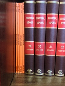
Previous owners: Phillips Fox"The Industrial Reports are Australia’s only specialist full-text case report series on industrial and employment law. The Industrial Reports are the authorised reports of Fair Work Australia and the Industrial Relations Commission of NSW. The series also provides relevant decisions of the High Court, Federal Court, State and Territory Supreme Courts, and Federal and State Industrial Courts and Tribunals. Each reported case includes a detailed headnote highlighting the key issues and decision in the case. The Industrial Reports online archive begins from Volume 1 and includes PDF versions of the cases. The series is integrated with other Westlaw AU services including FirstPoint (subject to separate subscription), allowing users to quickly check the history and current status of every reported decision." from: http://www.thomsonreuters.com.au/industrial-reports-parts-only/productdetail/19996 No. of volumes: 157 Volume range: Vol. 9 parts 1-5 (1985) (unbound), Vol. 29 (1988-1989) - Vol. 168 (2007) (bound), Vol. 169 parts 1-4 (2008) (unbound), Vol. 170 parts 1-2 (2008) (unbound), Index Vol. 1-40 (1981-1992) (bound), Index Vol. 41-80 (1991-1998) (bound), Index 81-105 (1999-2001) (bound), Consolidated index Vol. 126-145 (2003-2005) (unbound), Consolidated index Vol. 126-150 (2003-2006) (bound) + Consolidated index Vol. 151-165 (2006-2007) (unbound) Missing volumes: Vol. 10-28, Index 106-125 Note: Vol. 140 is an Anthology covering 1990-2003 Editors: Hungerford, B. C. (Vol. 9) Peterson, R. J. (Vol. 9) Wright, F. L. (Vol. 9 - 81) Thomson, A. (Vol. 82 - 170 part 2) Anthology editor: Phillips, J. ISSN: 07288417arbitration; industrial -- australia -- law and legislation -
 Kew Historical Society Inc
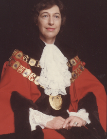
Photograph - Cr Jill O'Brien, Mayor of Kew 1983-84
... issues at both the state and local level. From her work... devoted a lifetime to social and environmental issues at both ...Born in Bendigo and trained as a nurse in the 1950s, Sonia Jill O’Brien devoted a lifetime to social and environmental issues at both the state and local level. From her work in the 1960s with the Family Planning Association of Victoria, of which she was a founding member, through to the 1990s as a member of the Ethics Committee of the Department of Health, she supported efforts to improve women’s health and reproductive rights. At the local level she was most active on committees that worked to save the natural and built environment. The Power-line Action Group, the Studley Park Conservation Society, and the Yarra Bend Park Trust all benefitted from her indefatigable endeavours as well her vision. In 1980, Jill O’Brien successfully stood for the Kew City Council and served as Mayor in 1983 and 1984. With an eye to preserving the past as well as guarding the future, she had the Mayoral robes restored and in 1980 and 1981 was president of the Kew Historical Society. The preservation and restoration of Villa Alba in Walmer Street owes much to her determined efforts throughout the 1980s. On Council, she chaired a number of committees involved in the saving of the Kew River Parklands from the proposed transmission line of the SEC. To this end, she was the Council representative on the Merri Yarra Municipal Protection Committee.Rare colour photograph, used as the official mayoral portrait of Cr Jill O'Brien.Formal civic portrait of Cr Jill O'Brien in red mayoral robes wearing lace jabot and cuffs. The portrait is part of the larger Jill O'Brien Collection donated by her daughters.cr jill o'brien, city of kew -- mayors, mayoral portraits -- city of kew -
 Kew Historical Society Inc
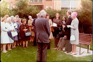
Photograph - Opening of the Dorothy Rogers Reserve, 1976
Dorothy Rogers wrote two major books on Kew's history: Lovely Old Homes of Kew (1961) and A History of Kew (1973). In addition to her published works, she was a regular contributor on issues of local history to suburban newspapers. Her archives are held in the collections of the State Library of Victoria and Kew Historical Society. Three years after her death in 1973, the Reserve was opened in her honour.Faded colour positive photograph of the opening of the Dorothy Rogers Reserve in 1976. The naming of the reserve honoured the contribution of the historian Dorothy Rogers, foundation member of the Society. The reserve is located on the north side of Studley Park Road just west of Kew Junction. Inscribed verso: "Members and relatives of the late Dorothy Rogers. Memorial reserve named and unveiled in her honour by (Cr Whiting Mayor) and City Manager Mr Fell 1978. In respect for her great research and service to the history of early Kew, and other places."dorothy rogers reserve, public parks -- kew (vic.) -
 Kew Historical Society Inc
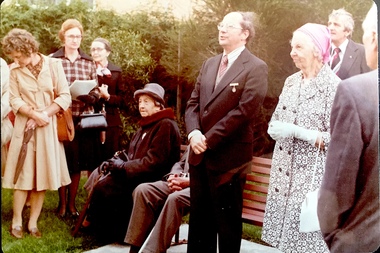
Photograph - Opening of the Dorothy Rogers Reserve, 1976
Dorothy Rogers wrote two major books on Kew's history: Lovely Old Homes of Kew (1961) and A History of Kew (1973). In addition to her published works, she was a regular contributor on issues of local history to suburban newspapers. Her archives are held in the collections of the State Library of Victoria and Kew Historical Society. Three years after her death in 1973, the Reserve was opened in her honour.Faded colour positive photograph of the opening of the Dorothy Rogers Reserve in 1976. The naming of the reserve honoured the contribution of the historian Dorothy Rogers, foundation member of the Society. The reserve is located on the north side of Studley Park Road just west of Kew Junction. Inscribed verso: "Left to right: Mrs Rogers Jnr, Joy Stewart, Miss Jenkins sitting / Mrs Richardson and Mr Richardson, Brother of D. Rogers), Mayor Cr Whiting, City Manager Mr Fell, Background / KHS President Miss Hall, Mr B O'Neill KHS member, / taken during the memorial unveiling of the Dorothy Rogers Reserve"dorothy rogers reserve, public parks -- kew (vic.) -
 Surrey Hills Historical Society Collection
Photograph, Staff and students of Surrey Hills Primary School, Empire Day celebrations, 1911
Date is approximate; early Empire Day celebrations were held in May each year between 1906 and 1911 to commemorate Queen Victoria's birthday. Headmaster, George Bennett was later headmaster at Balwyn State School, which his son Gordon (later General Gordon Bennett) attended. Miss Amy Wise was a teacher at Surrey Hills State School for her entire career. (There is information in filing cabinet re Amy Wise). Note (undated) from John Reaburn states that an issue of SHNN claimed Major General Bennett was a pupil at SHPS. He stated: "I very much doubt this, as he was 19 years of age when his father was headmaster in 1906. Before that the whole family attended Balwyn State School. The statement should be substantiated or corrected".Black and white photo copied from a postcard of staff and students assembled outside Surrey Hills Primary School for Empire Day celebrations. Some children carry Union Jack flags. The cadet corps of the school stands in line on the path against the picket fence of the school carrying drums and 'rifles'. The male students are assembled in line at the edge of the road and the female students are assembled in the middle of the road. There are a number of adults in the background, presumably teachers and parents; two are identified. Centre is headmaster, Mr George Bennett and at the right is teacher, Miss Amy Wise. The photo is taken in Beatrice Avenue looking towards Canterbury Road. An Edwardian or Victorian style house can be seen on the corner of Beatrice Avenue and Canterbury Road.Within the original image: State School, Surrey Hillssurrey hills primary school, empire day celebrations, education, primary education, schools, cadets, beatrice avenue, post card, mr george bennett, miss amy wise, mr john reaburn -
 National Wool Museum
Newspaper - Dalgety N.Z.L., Merchandise Bulletin, July 1966, Dalgety N.Z.L, July 1966
Eight page product catalogue with printed blue and black text, graphics and photographs. front: [printed] DALGETY-N.Z.L. / JULY 1966 ISSUE / MERCHANDISE BULLETIN / ALL THE PRODUCTS CATALOGUED ARE OBTAINABLE AT / DALGETY-N.Z.L. BRANCHES AT STATE PRICES F.O.R. MELBOURNEagriculture, animal management, sheep, rural industry, dalgety, product catalogue, merchandise bulletin -
 Federation University Art Collection
Photograph, Frank Golding, 'Three-quarter Time' - by Frank Golding, 2001
Frank Patrick Golding (1938 - ) This item is part of the Federation University Art Collection. The Art Collection features over 1000 works and was listed as a 'Ballarat Treasure' in 2007. Frank Golding is an author, researcher, historian, consultant: Honorary Senior Research Fellow at Federation University in Victoria, Australia. His formal qualifications are TPTC (Ballarat), BA (Melb), BEd (Melb), Dip MT (UNE), MA (Hons) (London). He has taught English and History in several schools. Frank Golding was employed as Principal at three schools including a multi-site English language centre for refugees and other new arrivals. Later he taught in and managed curriculum and equity programs in education departments and universities. Finally he is the author of 12 published books including a memoir, An Orphan’s Escape: Memories of a Lost Childhood (Lothian, 2005) which describes his childhood as a Ward of the State of Victoria in the ‘care’ of three foster mothers and three institutions. Golding lived in the Ballarat Orphanage from 1943 to 1953. It is his childhood experiences that underpin Golding's active involvement in ‘care’ leaver issues as an advocate and lobbyist. Golding is a Life Member of CLAN (Care Leavers of Australasia Network) the peak body of Care Leavers for Care leavers run by Care Leavers.Image of bird on 1/2 orange citrus fruit - a play on childhood memory of oranges at 3/4 timeSignature on label on backart, artwork, frank golding, bird, federation college, photography, colour photography, alumni -
 Federation University Art Collection
Print - Printmaking - Lithograph, Tulloch, David, 'Great Meeting of Gold Diggers Dec 15th 1851' by Thomas Ham, 1852
One of the first large goldfield meetings was at Castlemaine in 1851. After the extraordinary success of the Mt Alexander Diggings the Government issued a proclamation, raising the licence fee from thirty shillings to three pounds. As soon as these intentions became known a public meeting of miners was held. For miles around work ceased, with diggers travelling as far as Bendigo to attend the meeting. It is estimated that around 18,000 people attended the meeting. The notes with the engraving state The trees in this locality are chiefly Stringybark; some of them are peeled of their covering, as many persons prefer erecting bark huts to living in a comfortless tent. The various groups, and costumes of the men, are characteristic of our gold digging community. This item is part of the Federation University Art Collection. The Art Collection features over 2000 works and was listed as a 'Ballarat Treasure' in 2007.Colour lithograph of a meeting of diggers at a meeting in Mt Alexander. The meeting was the result of goldfields agitations against the license fee. lower centre "Great Meeting of Gold Diggers Dec 15th 1851" lower left side "Drawn By D. Tulloch" lower right side "Engraved by Thomas Ham"art, artwork, ham, thomas ham, tulloch, castlemaine, goldfields agitation, printmaking, edition, coloured lithograph, david tulloch, gold pan, shovel, wheelbarrow, waggon, bark hut, ring barked tree, gold mining -
![Painting - Artwork - Painting, [Boost It] by Josh Muir, c2014](/media/collectors/530576742162ef0fa09a2288/items/573d58712162f11db090922b/item-media/5b67ae0d21ea6e0344f91cc6/item-fit-380x285.jpg) Federation University Art Collection
Federation University Art CollectionPainting - Artwork - Painting, [Boost It] by Josh Muir, c2014
Josh MUIR (14 August 1991- 05 February 2022 ) Yorta Yorta/Gunditjmara/Barkinjl Muir's art draws on hip-hop and street art culture and often depicts the history of indigenous people and European settlers. He spent a lot of time in his teens researching and enjoying public art, especially graffiti. Inspired by the commitment of graffers he was inspired by the concepts they illustrate. He started expressing his own ideas with pen and pad and once the basic concept down and it was tangible and could be converted that to canvas or walls. Muir experimented with spray and stencil work a lot in his teens and later branched out into acrylic paints, paint pens, and digital forms of Art. iN 2014 Josh Muir was THE Australian Indigenous Mentoring Experience'S (AIMe) Program Manager Assistant at Federation University Australia in Ballarat.Australian Indigenous Mentoring Experience Z In 2016 Josh Muir's work 'Still Here', projected onto the front wall of the National Gallery of Victoria was critically acclaimed. At that time he stated: "‘I am a proud Yorta Yorta/ Gunditjmara man, born and living in Ballarat, Victoria. I hold my culture strong to my heart – it gives me a voice and a great sense of my identity. When I look around, I see empires built on aboriginal land. I cannot physically change or shift this, though I can make the most of my culture in a contemporary setting and use my art projects to address current issues of reconciliation." In 2016 Josh Muir was awarded the second recipient of HMS Trust’s Hutchinson Indigenous Fellowship at University of Melbourne, based at the Victorian College of the Arts (VCA). The Fellowship was created to enable Indigenous artists to undertake significant projects of their choice.Signed lower right "jmuir"josh muir, artwork, artist, aboriginal, hutchinson indigenous fellowship -
![Artwork - Painting, [AMuir] by Josh Muir, 2014](/media/collectors/530576742162ef0fa09a2288/items/573d58e72162f11db090a2a8/item-media/5b67adc321ea6d034478bf31/item-fit-380x285.jpg) Federation University Art Collection
Federation University Art CollectionArtwork - Painting, [AMuir] by Josh Muir, 2014
Josh MUIR (1991- ) Yorta Yorta/Gunditjmara Muir's art draws on hip-hop and street art culture and often depicts the history of indigenous people and European settlers. He spent a lot of time in his teens researching and enjoying public art, especially graffiti. Inspired by the commitment of graffers he was inspired by the concepts they illustrate. He started expressing his own ideas with pen and pad and once the basic concept down and it was tangible and could be converted that to canvas or walls. Muir experimented with spray and stencil work a lot in his teens and later branched out into acrylic paints, paint pens, and digital forms of Art. In 2016 Josh Muir's work 'Still Here', projected onto the front wall of the National Gallery of Victoria was critically acclaimed. At that time he stated: "‘I am a proud Yorta Yorta/ Gunditjmara man, born and living in Ballarat, Victoria. I hold my culture strong to my heart – it gives me a voice and a great sense of my identity. When I look around, I see empires built on aboriginal land. I cannot physically change or shift this, though I can make the most of my culture in a contemporary setting and use my art projects to address current issues of reconciliation." In 2016 Josh Muir was awarded the second recipient of HMS Trust’s Hutchinson Indigenous Fellowship at University of Melbourne, based at the Victorian College of the Arts (VCA). The Fellowship was created to enable Indigenous artists to undertake significant projects of their choice.josh muir, artist, artwork, aboriginal, hutchinson indigenous fellowship -
 Vision Australia
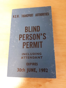
Card - Object, N.S.W. Transport Authorities Blind Person's Permit, 1982
The travel pass was used by NSW State Rail Authority to ascertain that the bearer was indeed a blind person and entitled to free travel. This example was numbered 4017 and was issued in the name of Mr N.L. Walker. It outlines what the named is authorised to obtain including 'Free Travel' which includes first or economy class, whichever is desired on State Rail Authority or Urban Transit Authority rail, bus and ferry services (except Hydrofoil) for journeys wholly within the stipulated N.S.W. areas and on Australian Government bus services in Canberra and also outlines details for 'Concession Travel'. 1 rectangular travel pass with blue cloth cover and black text On the cover of this Travel pass it states; 'N.S.W. Transport Authorities Blind Person's Permit, Including Attendant, Expires 30th June, 1982'. royal blind society of nsw, nsw state rail authority -
 University of Melbourne, Burnley Campus Archives
Booklet (Item), A Three Year Course in School Horticulture by E.F. Murnane
... 66-page booklet with card cover, issued by the Victorian... with card cover, issued by the Victorian State Schools ...school horticulture, victorian state schools' horticultural society, e.f. murnane -
University of Melbourne, Burnley Campus Archives
Air Raid Precautions; Manual of General Precautions (Fourth Edition)
... Booklet with card covers, 72pp. Issued by the State... manuals Signed J.L.Provan Booklet with card covers, 72pp. Issued ...Signed J.L.Provanair raids, civil defence, training manuals -
 Surrey Hills Historical Society Collection
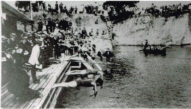
Photograph, Carnival Day at Surrey Dive, Possibly 1909
This photo records one of the swimming carnivals held at the Surrey Dive, the first of which was organised in 1907. It was at the 1907 carnival that champion swimmer Frank Beaurepaire won the one-mile championship in record time. In the era before purpose-built municipal swimming pools, Surrey Dive was a popular destination for swimming and people came to it from many Melbourne suburbs. It operated from 1905 to 1967. It was the newly formed Surrey Park Swimming Club (established in 1905) that petitioned the Box Hill Council to purchase the former quarry site associated with the Box Hill Brick Works. A ramp, bathing sheds, springboards, and eventually a 10-lane course were developed, making the Dive the first Olympic standard pool in Australia. The carnivals attracted huge crowds. The original use as a quarry explains the notorious depth of the swimming hole and the sheer, steep cliffs surrounding it. These posed obvious safety issues, as did the water quality. Ivy Lavinia Weber, who was the second woman to be elected to the Victorian parliament (the first at a general election) and renowned for her commitment to health and physical fitness, campaigned for State government assistance to build new baths. These were built adjacent to the Dive and were opened in 1939. The Dive continued as a facility used by experienced swimmers until 1967 when it closed due to the drought causing the water to dry up. Today the site has been turned into an ornamental lake. This image was used as a mural in the refurbishment of the Box Hill Aqualink. The image has strong associations with early industry (brick making), recreation and particularly the early history of the sport of swimming.Black and white photo with a white border. Scan shows image only. It shows 3 men diving from a wooden platform into an area of water beneath higher banks. There is a boat in the background, a building to the LHS of the photo and many spectators in boater hats on the platform, some in bathing suits along a ledge and many around the top of the bank. Two men in the LH foreground may be officials.Printed long the bottom edge of the frame: "An image from history - Carnival Day at the Dive. / (photo: Box Hill Council)"surrey dive, box hill brick works, swimming, surrey park swimming club, (mr) frank beaurepaire, (mrs) ivy lavinia weber, swimming carnivals -
Vision Australia
Audio - Sound recording, Vision Australia, Around Vision Australia: Episode 46
Covering issues and news about Vision Australia and the opportunities it provides for clients, volunteers and staff. Host: Stephen Jolley with guest interviews by Valerie Thomas. Recording of the Making Difference Awards ceremony, which took place in Melbourne on 21st July, 2006. One of those awarded was the Victorian State Government for introducing electronic voting for blind or vision impaired, making it the first-time people from this community were allowed a secret vote. Megan Denyer provides an update on the relationship VA have with Prime Television.1 digital sound file in WAV formatradio shows, vision australia, stephen jolley, gerard menses, megan denyer -
 Public Record Office Victoria
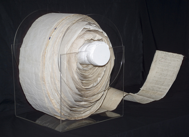
Document (item) - The 'Monster' Women’s Suffrage Petition
It took just six weeks in the spring of 1891 to collect nearly 30,000 signatures on the ‘Monster Petition’ for women’s suffrage. Dedicated suffragists collected an average of 5,000 signatures a week (over 700 per day) before the petition was presented to the Victorian Parliament in September 1891. The six-week drive proved the determination of the suffragists, and was one of first major steps along the road to 1908 and the achievement of women’s franchise. Now a prized possession of the State of Victoria, the petition itself was truly a ‘monster’, running 20 centimetres across and 260 metres in length. Several men were required to carry it into Parliament. Its sheer size and unique shape make it a marvel; a stack of paper with an equal number of signatures would not be nearly as impressive as the huge, winding roll presented to Premier James Munro. Quoted from the article ‘The “Monster Petition” and the Women of Davis Street’ by Brienne Callahan, in Provenance: The Journal of Public Record Office Victoria, issue no. 7. -
![Artwork, other - Artwork, [Heart of a Champ] by Josh Muir, 2014](/media/collectors/530576742162ef0fa09a2288/items/5a583f0221ea6811d47d8349/item-media/5b67ad7a21ea6c034496b4fc/item-fit-380x285.jpg) Federation University Art Collection
Federation University Art CollectionArtwork, other - Artwork, [Heart of a Champ] by Josh Muir, 2014
Josh MUIR (1991-05 February 2022) Yorta Yorta/Gunditjmara/Barkinjl Born Ballarat, Victoria Muir's art draws on hip-hop and street art culture and often depicts the history of indigenous people and European settlers. He spent a lot of time in his teens researching and enjoying public art, especially graffiti. Inspired by the commitment of graffers he was inspired by the concepts they illustrate. He started expressing his own ideas with pen and pad and once the basic concept down and it was tangible and could be converted that to canvas or walls. Muir experimented with spray and stencil work a lot in his teens and later branched out into acrylic paints, paint pens, and digital forms of Art. In 2016 Josh Muir's work 'Still Here', projected onto the front wall of the National Gallery of Victoria was critically acclaimed. At that time he stated: "‘I am a proud Yorta Yorta/ Gunditjmara man, born and living in Ballarat, Victoria. I hold my culture strong to my heart – it gives me a voice and a great sense of my identity. When I look around, I see empires built on Aboriginal land. I cannot physically change or shift this, though I can make the most of my culture in a contemporary setting and use my art projects to address current issues of reconciliation." In 2016 Josh Muir was awarded the second recipient of HMS Trust’s Hutchinson Indigenous Fellowship at University of Melbourne, based at the Victorian College of the Arts (VCA). The Fellowship was created to enable Indigenous artists to undertake significant projects of their choice. He was also a Telstra National Indigenous and Torres Strait Islander Youth Art Award winner. The Koorie Heritage Trust, the National Gallery of Australia, the National Gallery of Victoria, the Art Gallery of the Northern Territory and Federation University Australia all own his work. Digital output on stretched canvas.josh muir, artist, artwork, aboriginal, hutchinson indigenous fellowship -
![Artwork, other - artwork, Josh Muir, [Portrait] by Josh Muir, 2014](/media/collectors/530576742162ef0fa09a2288/items/5a583f9321ea6811d47e173d/item-media/5b67ad2d21ea6b0344f6a8e0/item-fit-380x285.jpg) Federation University Art Collection
Federation University Art CollectionArtwork, other - artwork, Josh Muir, [Portrait] by Josh Muir, 2014
Josh MUIR (1991- ) Yorta Yorta/Gunditjmara/Barkinjl Muir's art draws on hip-hop and street art culture and often depicts the history of indigenous people and European settlers. He spent a lot of time in his teens researching and enjoying public art, especially graffiti. Inspired by the commitment of graffers he was inspired by the concepts they illustrate. He started expressing his own ideas with pen and pad and once the basic concept down and it was tangible and could be converted that to canvas or walls. Muir experimented with spray and stencil work a lot in his teens and later branched out into acrylic paints, paint pens, and digital forms of Art. In 2016 Josh Muir's work 'Still Here', projected onto the front wall of the National Gallery of Victoria was critically acclaimed. At that time he stated: "‘I am a proud Yorta Yorta/ Gunditjmara man, born and living in Ballarat, Victoria. I hold my culture strong to my heart – it gives me a voice and a great sense of my identity. When I look around, I see empires built on aboriginal land. I cannot physically change or shift this, though I can make the most of my culture in a contemporary setting and use my art projects to address current issues of reconciliation." In 2016 Josh Muir was awarded the second recipient of HMS Trust’s Hutchinson Indigenous Fellowship at University of Melbourne, based at the Victorian College of the Arts (VCA). The Fellowship was created to enable Indigenous artists to undertake significant projects of their choice.A computer generated artwork on stretched canvas.josh muir, artist, artwork, aboriginal, hutchinson indigenous fellowship -
![Artwork, other - Artwork, Josh Muir, [Eye] by Josh Muir, 2014](/media/collectors/530576742162ef0fa09a2288/items/5a58423321ea6811d480bfdf/item-media/5b67ace421ea6a0344f0061b/item-fit-380x285.jpg) Federation University Art Collection
Federation University Art CollectionArtwork, other - Artwork, Josh Muir, [Eye] by Josh Muir, 2014
Josh MUIR (1991- ) Yorta Yorta/Gunditjmara Muir's art draws on hip-hop and street art culture and often depicts the history of indigenous people and European settlers. He spent a lot of time in his teens researching and enjoying public art, especially graffiti. Inspired by the commitment of graffers he was inspired by the concepts they illustrate. He started expressing his own ideas with pen and pad and once the basic concept down and it was tangible and could be converted that to canvas or walls. Muir experimented with spray and stencil work a lot in his teens and later branched out into acrylic paints, paint pens, and digital forms of Art. In 2016 Josh Muir's work 'Still Here', projected onto the front wall of the National Gallery of Victoria was critically acclaimed. At that time he stated: "‘I am a proud Yorta Yorta/ Gunditjmara man, born and living in Ballarat, Victoria. I hold my culture strong to my heart – it gives me a voice and a great sense of my identity. When I look around, I see empires built on aboriginal land. I cannot physically change or shift this, though I can make the most of my culture in a contemporary setting and use my art projects to address current issues of reconciliation." In 2016 Josh Muir was awarded the second recipient of HMS Trust’s Hutchinson Indigenous Fellowship at University of Melbourne, based at the Victorian College of the Arts (VCA). The Fellowship was created to enable Indigenous artists to undertake significant projects of their choice.Digital print on stretched canvas.josh muir, artist, artwork, aboriginal, hutchinson indigenous fellowship -
 Falls Creek Historical Society
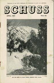
Journal - Schuss Vol. 17. No. 4 April 1951
Schuss was advertised as Victoria’s Official Ski Journal It was issued monthly from 1935 to 1961 except during the war when summer issues covered two months. This continued after the war, but it averaged 10 issues annually over its 25 year life. Schuss was published by the Ski Club of Victoria which had a membership of 38 Ski Clubs and demanded to be recognised as the prime authority on skiing in the state. The other 30 ski clubs with 85% of the members disagreed and the politics of skiing became heated. These clubs formed the Federation of Victorian Ski Clubs with their own journal, Ski Horizon. With the establishment of the Victorian Ski Association, Ski-Horizon published its last issue in Nov - Dec. 1955 and the role of the official journal was fully taken over by “Schuss”. This item is significant because it contains stories, images and information documenting the development of the ski industry in Victoria.The journal features stories and events chronicling developments in Victoria and internationally. Items related to the Falls Creek Area in this issue include:- Cover - Features a photo by H.Gibbs titled "On the road to Falls Creek, Bogong High Plains"schuss journal, the ski club of victoria