Showing 171474 items
matching streets
-
 Warrnambool and District Historical Society Inc.
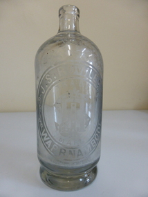
Bottle, J. S Rowley
... Corner of Timor and Banyan Streets, Warrnambool, Victoria ...The making of cordials and aerated waters was an important industry in Warrnambool from the time of the first settlement up to the 1980s. John Rowley was a prominent producer of aerated waters and cordials from 1868 to his death in 1893 (the Warrnambool Steam Aerated Works). He was known for his originality in the production of soft drinks and produced 20 varieties of drinks, including his own Henneberry Wine and Lime Fruit Champagne, both non-alcoholic. In the 1870s he was producing 600 dozen bottles a day and in the 1880s his cordial factory occupied half an acre of land and employed 13 people. He won many awards for his products at local Agricultural Shows. Warrnambool cordial bottles are of considerable significance as examples of an important industry now gone. Rowley is a significant person in the history of 19th century Warrnambool industries and Rowley bottles are of considerable importance, especially this one, made for efferverscent drinks. This is a heavy glass bottle (no stopper) possibly used for hop bitters or ginger wine or some contents that had high efferverscent qualities. The bottle has a heavy indented base. Oval etching ‘J.S.,Rowley Warrnambool’ with ‘Trade Mark’ and monogram. ‘J.R.’ in the centre of the oval. ‘Made in France’ is at the bottom edge of the oval inscriptions.warrnambool, john rowley warrnambool, rowley softdrinks, warrnambool steam aerated works, rowley bottle -
 Stawell Historical Society Inc
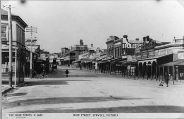
Photograph, Main Street Stawell looking East towards the Post Office
This photograph is of Main Street Stawell looking East around c 1920's. The photo was taken from just below Main & Wimmera Street corner. On the left side is the two story Post Office building. The photograph shows the telegraph poles in the street. Also Copley Post Office Hotel 1912- 22 and other business. On the road are a few people one pushing a trolly, one on a bike and two people in a horse drawn cart. Gustav Mahnke's Bakery is on right.Two Black & White photographs depicting the main street in Stawell's commercial business area in c 1920's. The view shows some two story buildings, shops with verandah's. One horse drawn vehicle, a person on a bike and a few people in the street. There is also a paper print of the photograph donated by Robyn Mackenzie Bacchus Marsh in 2009 The Rose series, P 1639 Main Street, Stawell, Victoriastawell business shops streetscape -
 Ringwood and District Historical Society
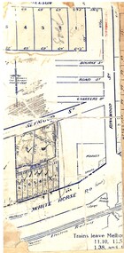
Map, Partially trimmed copy of a retail and residential auction advertisement, Ringwood, Vic. - 1926
One of 3 unrelated land subdivision maps on cardboard backing. Numbered allotments on Nelson Street, Seymour Street and Whitehorse Road, Ringwood.W.J. Bonwick, Licensed Surveyor, Phone WU4830. Location map also includes Bourke Street, Bond Street, Charter Street, Ringwood Street, and Shops and Market sites in Ringwood. -
 Tatura Irrigation & Wartime Camps Museum
Photograph - original, Hogan Street Tatura 1932, 1932
Photograph showing Hogan street, Tatura in 1932. Showing telegraph poles, palm tree, big tree, fence and residence of Youngs cafe.Black and white original photograph of Hogan Street, Tatura, looking east. 1932.on back: Tatura, Hogan Street. looking east 1932. from corner - Youngs Cafe.hogan street tatura -
 Orbost & District Historical Society
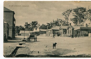
black and white photograph, early 20th century
This photograph shows the main street of Orbost and in particular, the Orbost Post Office.This is a pictorial record of the Main street of Orbost in the early 20century.A black / white photograph which has been taken diagonally across the post office in the main street of Orbost. Buildings are wooden. The road is unsealed. There are several people outside the building, a dog in the foreground and a small cart on the left side.at top front - MAIN STREET, ORBOSTorbost nicholson-street-orbost post-office-orbost main-street-orbost -
 Tatura Irrigation & Wartime Camps Museum
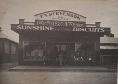
Photograph - original, Kodak, Stevenson's Grocery Shop, 1944
Original photograph of Frank Stevenson's grocery shop, 179 Hogan Street, Tatura. 1944. Miss Frances Stevenson with bike, pictured. Sign writing on top, Robur Tea, Sunshine Biscuits.Original sepia photograph of Stevenson's Grocery shop (exterior), Hogan Street, Tatura. Residence of butcher shop on right, part of cafe residence on left.on back: 179 Hogan Street Tatura.1944 -
 Phillip Island and District Historical Society Inc.
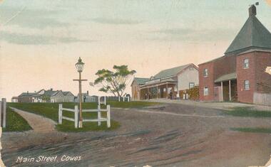
Photograph - Post Card, Early 1900's
Postcard from "Mona Vale" Cowes to Miss Ada Copas, Sunbury Crescent, Surrey Hills. Handed in to Heritage Centre July 1984 on behalf of Mrs R Dalzell, 55 Golden Way, Bulleen. 3105.Coloured postcard of the Main Street, Cowes Main Street, Cowes"main street cowes, phillip island, cowes phillip island, phillip island, r. dalzell -
 Port Melbourne Historical & Preservation Society
Photograph - View of Port Melbourne, c.1890
.The view of Port Melbourne looking towards the sailing ships moored at Railway Pier is believed to have been taken from the Fire Tower off Liardet Street. Swallow's chimney can be seen behind the Graham Street Methodist church. This photograph is a part of a wider view of an original photograph taken for International Exhibition of 1873.View of Port Melbourne looking towards Town Pier with Swallow 's chimney behind the Graham Street Methodist Church.On back Methodist Church Graham Street Swallow's Chimney in Back groundreligion - methodist church graham street, swallow & ariell ltd, fire tower -
 Federation University Historical Collection
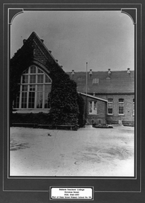
Photograph - Framed Photograph, Ballarat Teachers' College
These images were hung in the corridor of the University of Ballarat School of Education (Mount Helen). It most probably dates from around the time of the transfer of the College. The Ballarat Teachers' College was established after the Victorian State Government and the State Education Department decided to establish two provincial teachers' colleges, at Ballarat and Bendigo. On 04 May 1926 W.H. Ellwood (Principal), Miss A. Bouchier, and Mr A.B. Jones, welcomed the first enrolment of 61 students to undertake the one year course. In 1927 the College moved to the former Ballarat East Town Hall in Barkly Street, which was remodelled for their use. It closed in December 1931 due to the Great Depression. In 1946 Ballarat Teachers' College reopened and relocated to the Dana Street State School. The building used by the Teachers' College was the original bluestone building facing Doveton Street South. It was originally planned to open as a women's college, for whom the residence at 130 Victoria Street was purchased, but the decision was made to admit resident men from Ballarat. Mr T.W. Turner was appointed as Principal in 1951 and directed the introduction of a two year course for the Trained Primary Teachers' Certificate. The former one year course was terminated at the end of 1951. In 1958 the College was relocated to a custom built facility at Gillies Street, in close proximity to the Ballarat Botanical Gardens. Numbers increased with the introduction of the Trained Infant Teachers' Certificate course under the guidance of Mary Egan. With the introduction of a three year Diploma Course in 1968 accommodation became cramped. The introduction of the Diploma of Teaching (Primary) led to the Trained Infant Teachers' Certificate being discontinued in 1969, and the end of the Trained Primary Teachers' Certificate in 1969. Secondary Art and Craft students began studies at Ballarat Teachers' College in 1969 under Mr Ted Doney. In 1971 Mr D. Watson was appointed Principal. The State College of Victoria was proclaimed by Order in Council on 24 July 1973, and Ballarat Teachers' College became a constituent college of the State College of Victoria, and was known as State College of Victoria, Ballarat. By 1975 the College moved to Mount Helen as part of the Ballarat College of Advanced Education. Pre service teachers currently undertake their studies on the Mount Helen Campus of Federation University. ("Ruffians Attempted to Carry of the School Tent: A History of State Education in Ballarat", 1974, p73-4.) Framed black and white photograph of: .1) the former Ballarat East Town Hall .2) the old Dana Street Primary School during the era it was used as the Ballarat Teachers' College. The photographed is surrounded by a green matboard. .3) Ballarat Teachers' College, Gillies Street.Plaque under photo "Ballarat Teachers' College Doveton Street 1926, 1946-1957 (Part of Dana Street Primary School No. 33)ballaratteachers college, dana street primary school, teacher education, 00607 -
Tatura Irrigation & Wartime Camps Museum
Photograph, Chas Brady Story
Original photograph of Chas Brady's Store in Casey Street, Tatura. One of the very early stores in Tatura. Grocer, draper, general merchant. Also partly in photo, is a farm machinery store, Horsby, Reapers, Binders.Black and white photograph of Chas Brady Store in Casey Street, Tatura. Horse and cart, men and women and children outside store but names unknown.Chas Brady Store Casey Street Tatura.chas brady store tatura -
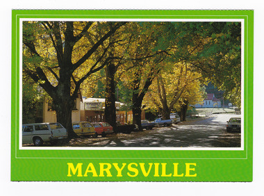
 Marysville & District Historical Society
Postcard (Item) - Colour postcard, Scancolor (Australia) Pty Ltd, MARYSVILLE Victoria-Australia, Unknown
A colour photograph of trees in Autumn lining Murchison Street in Marysville in Victoria.A colour photograph of trees in Autumn lining Murchison Street in Marysville in Victoria. This postcard was produced by Scancolor Australia as a souvenir of Marysville.MARYSVILLE/ Victoria-Australia Spectacular autumn colours of the main street. CS 4065 scancolor Australia (03) 955 1944marysville, victoria, murchison street, autumn, scancolor australia, postcard, souvenir -
 Marysville & District Historical Society
Postcard (item) - Colour postcard, Scancolor (Australia) Pty Ltd, MARYSVILLE Victoria-Australia, Uknown
A colour photograph of trees in Autumn lining Murchison Street in Marysville in Victoria.A colour photograph of trees in Autumn lining Murchison Street in Marysville in Victoria. This postcard was produced by Scancolor Australia as a souvenir of Marysville.MARYSVILLE/ Victoria-Australia Spectacular autumn colours of the main street. CS 4065 scancolor Australia (03) 955 1944marysville, victoria, murchison street, autumn, scancolor australia, postcard, souvenir -
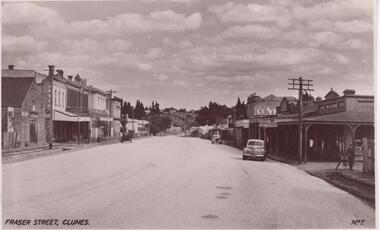 Clunes Museum
Photograph, VALENTINE'S POST CARD, UNKNOWN
BLACK AND WHITE PHOTO OF FRASER STREET, CLUNESFRASER STREET CLUNESlocal history, photography, photographs -
![EJ Harvey, Motor Engineers, High Street [Kew East], circa 1925](/media/collectors/550653872162f11fb04854aa/items/586f9929d0ce2607f0b81f1a/item-media/586f99e0d0ce2607f0b8546f/item-fit-380x285.jpg) Kew Historical Society Inc
Kew Historical Society IncPhotograph - Photograph [copy], EJ Harvey, Motor Engineers, High Street [Kew East], circa 1925, c. 1925
The building was in High Street, Kew East between Clyde and Oswin Streets. The site is currently (2017) occupied by a canoe retailer.Rare and historic photograph of an early business in the Harp Village shopping precinctGarage - E.J. Harvey, Motor Engineers workshop, High Street, East Kew. The garage was on the corner of Clyde Street.Inscription reverse: "High Street, East Kew - present site of Harvey Phillips Retro Vision[*] shop. Gift of Edna Phillips. Edna loaned KHS the original photo and KHS had it copied." * Note - Harvey Phillips Retravision not Retro Vision].motor engineers (kew), garages (kew), e.j. harvey -
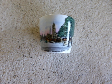 Warrnambool and District Historical Society Inc.
Souvenir - Souvenir Egg Cup, 1940s
Small souvenirs such as plates, cups, mugs, ash trays and jars, showing scenes and buildings in Warrnambool, were first produced in the late 19th century for all towns and cities in Australia and were popular in the early to mid 20th century. They are still produced for tourists today. The Historical Society has several of these souvenir dishes but this is the first souvenir egg cup we have seen. The image of Liebig Street is appropriate as this is the main street in Warrnambool. This souvenir egg cup has no great significance historically but it is representative of the type of souvenir sold to tourists and it is interesting because of its age (1940s). It will be useful for exhibitions.This is a white china egg cup with a coloured image of Liebig Street, WarrnamboolUnder the image – ‘Liebig Street, Warrnambool, Vic.’ On the base – ‘Royal Grafton Bone China, Made in England’ warrnambool, warrnambool souvenirs, liebig street -
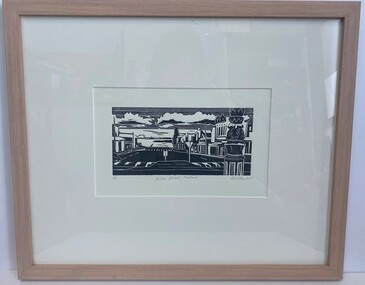 Glenelg Shire Council Cultural Collection
Artwork, other - Linocut, Bob Stone, Julia Street, 2007
Artwork features streets from Portland Victoria.Black and white linocut print. Image based on Julia Street Portland Victoria showing the Street and buildings looking toward the ocean. Foreground right an up close replicate of the sign pole of the middle of the roundabout between Percy and Julia Street, raised road crossings, road signs, Norfolk Island tree, ocean is visable with various Port structures. Sky is lined with clouds shaded black underneath.Along the bottom of the print written in grey lead 4/5 Julia Street, Portland Bob Stone 2007portand, julia street portland, linocut -
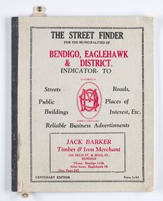 City of Greater Bendigo - Civic Collection
Book - Street Directory, McConnell Publisher, The Street Finder
General district street, business and services directory aimed less at the tourist market and more at the Bendigo and Eaglehawk population. Includes advertising. Index is extensive and includes services such as child care centres, cemeteries, theatres and schools.Thirty two page, printed and bound street and business directory for Bendigo, Eaglehawk and district. Grey card front cover with grey cardboard back cover. Printed in red and black ink. Includes Index for trades, streets and services such as banks, baths, sporting clubs and police stations. Majority of content is text and advertising and the only map included in the publication is printed inside the back cover.The Street Finder / for the municipalities of / Bendigo, Eaglehawk / & District. city of greater bendigo commerce, city of greater bendigo community groups, city of greater bendigo tourism, borough of eaglehawk, making a nation exhibition -
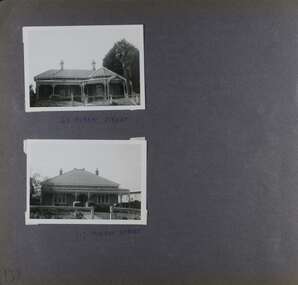 Glen Eira Historical Society
Album - Album page, Murray Street, Circa 1972
This photograph is part of the Caulfield Historical Album 1972. This album was created in approximately 1972 as part of a project by the Caulfield Historical Society to assist in identifying buildings worthy of preservation. The album is related to a Survey the Caulfield Historical Society developed in collaboration with the National Trust of Australia (Victoria) and Caulfield City Council to identify historic buildings within the City of Caulfield that warranted the protection of a National Trust Classification. Principal photographer thought to be Trevor Hart, member of Caulfield Historical Society. Most photographs were taken between 1966-1972 with a small number of photographs being older and from unknown sources. All photographs are black and white except where stated, with 386 photographs over 198 pages. 63 and 117 Murray Street houses are extant (Google maps image capture Dec 2018).Victorian Heritage Database - HO131 63 Murray Street Caulfield https://vhd.heritagecouncil.vic.gov.au/places/35569 (as of 14/08/2021) "Marston" at no. 63 Murray Street, Caulfield South, was built by J.E. Guest, a contractor resident in nearby Downshire Road, in 1889-90, presumably as a speculative venture together with the extant house at adjoining No.61. It is aesthetically significant. It is aesthetically significant (Criterion E) as an exceptionally richly ornamented medium sized Boom period villa in Caulfield South, being unusual in this respect in its locale and comparing with nearby "Sprouston" at 19 Blanche Street (1887). Important contributory elements include the polychrome brickwork, frieze and verandah including the half timbered gablet which would have been stylistically innovative in its day.Page 139 of Photograph Album with two landscape photographs of two different houses in Murray Street. Handwritten: 63 MURRAY STREET [under top photo] / 117 MURRAY STREET [under bottom photo] / 139 [bottom left]trevor hart, garden, verandah, murray street, elsternwick, victorian style, houses, marston, house names, j e guest, verandahs, polychrome bricks, cast iron work, chimneys -
 Phillip Island and District Historical Society Inc.
Photograph, Thompson Ave, Cowes Phillip Island, 1920
View looking up Thompson Avenue from The Esplanade. The Chicory Kiln built in 1870, a two storey brick building is adjoined by West's General Store, built in 1869 to cater for the needs of the Settlers. A large Gum Tree and finally houses follow on from these two buildings. In the foreground and to the left, is a small three sided fence and a gracious Gas Lamp on long pole.Cowes looking up Thompson Ave to Chapel Street. 1905Main Street Coweslocal history, photographs, streetscape, cowes, black & white photograph, mary robb -
 Whitehorse Historical Society Inc.
Photograph, Station Street Mitcham
... Streets ...Coloured photograph of Station Street Mitcham looking South. Main road is Whitehorse Roadstation street mitcham, streets -
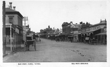
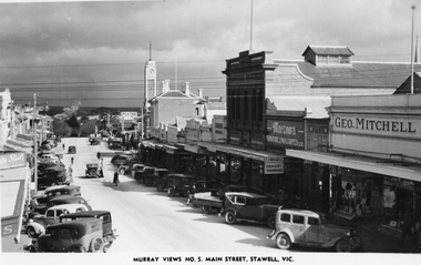 Stawell Historical Society Inc
Photograph, Main Street Stawell looking West with the Geo. Mitchell shop on right c 1940 -- Postcard
Murray Views No. 5. Main Street Stawell Vic. post card of street scene. The scene is looking west with the Geo Mitchell shop and Macrows furniture shop on the right. The street is full of parked cars c 1940's.Murray Views Postcard and also one enlargement of the street scene in Stawell looking west c 1940's.Murray View No. 5 Main Street, Stawell, Vic. (on the front) Real photograph produced in Australia by Murray View, Gympie, Q. (on the back). stawell business streetscape -
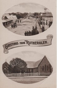 Rutherglen Historical Society
Image, Greetings from Rutherglen, 1910 to 1912
Black and white postcard with two oval photographs with "Greetings from Rutherglen" on a banner between them. The top photograph is of High Street, taken from the Main Street intersection looking south. The bottom one is of St Mary's Church, High Street.At bottom of top photo: "High Street" At bottom of bottom photo: "St Mary's Church, High Street"high street, st marys church -
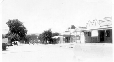 Linton and District Historical Society Inc
Photograph, Sussex Street, Linton - view to north, late 1920s or early 1930s
Dated to late 1920s or early 1930s as Nelson building has been renovated as a Californian bungalow. The earlier curvilinear parapet on the library building (see photo - Registration no. 166) has been squared off, and a small pedimented timber parapet has been added above.Black and white photograph of Linton's main street, Sussex Street. View of Railway Hotel, Nelson undertaker building, public library and "cash emporium". Cars parked and driving along Sussex St."Linton Main Street".sussex street linton, railway hotel, nelson undertakers, linton public library, cash emporium, transport, cars -
 Kew Historical Society Inc
Photograph, J F C Farquhar, Wellington Street From High Street, 1891
At the beginning of the 1890s, the Kew businessman and Town Councillor, Henry Kellett, commissioned J.F.C. Farquhar to photograph scenes of Kew. These scenes included panoramas as well as pastoral scenes. The resulting set of twelve photographs was assembled in an album, Kew Where We Live, from which customers could select images for purchase.The preamble to the album describes that the photographs used the ‘argentic bromide’ process, now more commonly known as the gelatine silver process. This form of dry plate photography allowed for the negatives to be kept for weeks before processing, hence its value in landscape photography. The resulting images were considered to be finely grained and everlasting. Evidence of the success of Henry Kellett’s venture can be seen today, in that some of the photographs are held in national collections.It is believed that the Kew Historical Society’s copy of the Kellett album is unique and that the photographs in the book were the first copies taken from the original plates. It is the first and most important series of images produced about Kew. The individual images have proved essential in identifying buildings and places of heritage value in the district.Very few of the natural or built features in this panoramic photograph of Wellington Street remain. The open land between High Street South and Denmark Street, then known as O’Shannessy’s Paddock, was to become a residential subdivision at the beginning of the 20th Century. On the far side of Denmark Street, bordered by a picket fence, is the Kew Railway Station (demolished 1957). Further east, the large building with the flagpole is the Kew Recreation Hall (demolished 1960), which was the centre of civic life for almost a century. The building was used for dances, civic functions and exhibitions. A bowling green, tennis courts, and a cricket ground surrounded the Hall. The dominant building in the photograph is Xavier College, founded in 1872 by the Society of Jesus. The first classes for pupils were held in 1878. It is presumed that Farquhar used its roof for two of his bird’s eye views.Wellington Street from High Streetkew illustrated, kew where we live, photographic books, henry kellett -
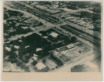 Chelsea & District Historical Society Inc
Photograph - Aerial Photo of Chelsea, c 1923
Points of interest in the photo are Fox Theatre, Chelsea Railway Station and the building site of Masons Theatre on the corner of Chelsea Road and Station Street. Mr William Herbert Hansom was a pioneer of aerial photography in Australia.Black and white aerial photo of Chelsea, bordered by Thames Promenade, Balantyne Avenue, Catherine Avenue and Chelsea Road, Station Street, The Strand, Bath Street.W. H. Hansom ("Manders") Aerial Artist, Personally Conducted Flights over Melbourne and Suburbs St James' Building Bourke Street, Melbournechelsea, aerial photo, station street, chelsea road, the strand, bath street, fox theatre, masons theatre, w. h. hansom, chelsea railway station -
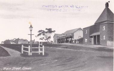
 Phillip Island and District Historical Society Inc.
Photograph, Main Street, Cowes, 1890
Part of a collection of Rose & Valentine Series of Postcards. Copied by John Jansson 1984View of Main Street, Cowes. Ladies & Children in foreground. Approx. 1890.Main Street, Coweslocal history, photography, photographs, postcards, phillip island, black & white postcard - copy, thompson ave cowes, cowes -
 Marysville & District Historical Society
Photograph (Item) - Black and white photograph, Kathleen & Tom Minahan, 1948
A copy of a black and white photograph of the main street in Marysville in Victoria.A copy of a black and white photograph of the main street in Marysville in Victoria. This street is now known as Murchison Street.Main Street Marysville 30th May - 12th June 1948 Kathleen & Tom Minahan Minahan - Honeymoonmurchison street, marysville, victoria -
 Stawell Historical Society Inc
Photograph, Main Street Stawell looking East with the Post Office on left & the Post Office Hotel on the right
Main Street Stawell looking East. Post Office on left, double story building. Note Post Office Hotel Rowland's as previously E. J. Copley . Real Photo Series M 673 1922. Six horse drawn carts along the street and people moving around the shops. Also the telegraph poles in this photo have 4 cross timber beams on the previous photo they only had 3 cross timber beams. Sepia photo of Main Street, Stawell c 1920's. The street scene show the commercial businesses of the time with horse and carts being the main form of transport.Main Street, Stawell. Victoria. Real Phot Series. M.673. Printed on the back "Published by the Valentine & Sons Publishing Co. Ltd. Melbourne Sydney & Brisbane.stawell streetscape -
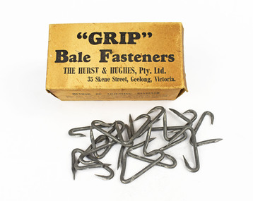 National Wool Museum
Bale Fastener
"Grip" bale fasteners,The Hurst & Hughes Pty Ltd, 35 Skene Street, Geelong, Victoria. Donated from the estate of the donors' father who had an involvement through the scouting movement with the Hurst family who invented bale clips."Grip" bale fasteners,The Hurst & Hughes Pty Ltd, 35 Skene Street, Geelong, Victoria."Grip" Bale Fasteners/ The Hurst & Hughes Pty Ltd, 35 Skene Street, Geelong, Victoria....shearing wool bales, hurst and hughes pty ltd, wool bale clips, hurst, mr harold e., shearing, wool bales -
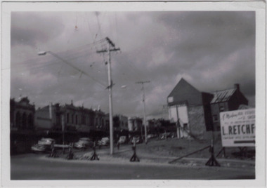 Kew Historical Society Inc
Photograph - Kew Junction during road widening, December 1958
Kew Junction is the intersection of five major roads - Denmark Street, High Street, High Street South, Studley Park Road and Princess Street. The original widening of High Street in the 1930s expanded that street by removing shops on the south side of the street from Cotham Road to Denmark Street. Further widening in 1958 removed shops at the west end of High Street to allow for increased traffic using Princes Street and Denmark Street.Original, black and white positive of Kew Junction, including the corner with Denmark Street during road widening in the 1958.Inscribed verso: "Kew Junction Dec 1958 / When the road was being widened by the removal of a number of shops / Notice saying Retchford's Estate agency's temporary office is at the top end of Denmark Street, Kew"kew junction, denmark street -- kew (vic.), major roadworks -- kew (vic.)