Showing 458 items matching "subdivision map"
-
 Federation University Historical Collection
Map - Documents, Documents relating to Land - Selection of Maps of subdivisions; Titles; Cemetery sections
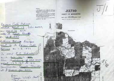
... - Selection of Maps of subdivisions; Titles; Cemetery sections Map ...Maps indicate the land owned in various areas of Victoria - Mornington Peninsula, Ascot / Creswick areaLand maps showing block divisions and owners. Edward Carter Holmes J.P. selected land and called it Launchley - later called Wambalano.jeetho, county of mornington, edward carter holmes, joseph clarke, catherine holmes, talbot, william coghill, pre-emptive right, tourello pre-emptive right, glendonald pre-emptive right, clunes, smeaton, ascot, counties of ripon and talbot, certificate of title, ballaarat general cemetery, new cemetery, poowong, helen coghill -
 Ringwood and District Historical Society
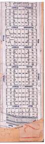
Map, Subdivision Clipping, Ringwood, Victoria (Undated, circa 1930)
Trimmed photocopy showing layout of numbered allotments in Ford Street, Best Street, Leonard Street (later David Street), Allen Street, Lavender Street, Pearwood Street, Emerald Street and Great Ryrie Street (mis-named Rylie Street), Ringwood, Victoria. Also marks location of 27 soldiers home allotments in Bedford Road.Handwritten notations include land title reference - LP11818. -
 Ringwood and District Historical Society
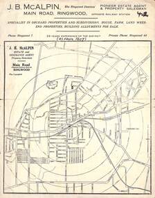
Document - Advertisement, Map of Ringwood District promoting J.P McAlpin - Pioneer Estate Agent & Property Salesman, Main Road, Ringwood. Undated, circa 1910
Buff coloured map with radiating distances marked at 1/4 mile intervals up to 1-3/4 miles from Ringwood railway station.Specialist in orchard properties and subdivisions. House, farm, land, weekend properties, building allotments for sale. Phone Ringwood 7. Private Phone Ringwood 44. 33 years' experience of the district. -
 Ringwood and District Historical Society
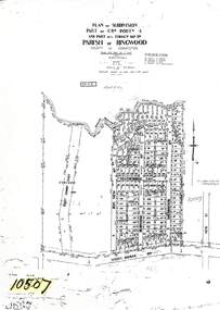
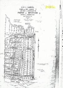
Map - Plan of Subdivision, Part of Crown Allotment 4, Parish of Ringwood, County of Mornington - 1925
... Ref 10507. Photocopy of subdivision with allotment numbers ...Photocopy of subdivision with allotment numbers and property dimensions. Subdivision includes Grant Crescent, Heatherbrae Avenue, Bon View Avenue, Burwood Avenue, Sherbrook Avenue and Whitehorse Road, Ringwood, Victoria. Area west of Bon View Avenue marked Electrical Commission East, Excised.W.B. & O. McCutcheon Stamp 13.1.25. Declared by W.J. Bonwick 24.12.24. Councis's consent on plan with F.D3 report. LP Ref 10507. -
 Ringwood and District Historical Society
Map - Plan of Subdivision, Part of Crown Allotment 4, Parish of Ringwood, County of Mornington - 1925, amended 1980
... . Map Plan of Subdivision ...Photocopy of subdivision with allotment numbers and property dimensions. Subdivision includes Grant Crescent, Heatherbrae Avenue, Margaret Street, Mary Street, Hillcrest Avenue, Bon View Avenue and Whitehorse Road, Ringwood, Victoria.W.B. & O. McCutcheon Stamp 13.1.25. Declared by W.J. Bonwick 24.12.24. Amended 15.8.80. LP Ref 10506. -
 Ringwood and District Historical Society
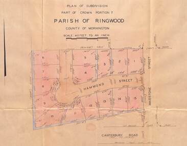
Map - Plan of Subdivision, Part of Crown Portion 7, Parish of Ringwood, County of Mornington - 1966
... , Essendon (Telephone) 37-2642, 37-2257, Ref 66/821. Map showing ...Map showing layout of and dimensions of 15 numbered allotments on Hammond Street, off Maidstone Street, Ringwood, VictoriaRichard Rogalsky, Licensed Surveyor, 23 Napier Street, Essendon (Telephone) 37-2642, 37-2257, Ref 66/821. -
 Ringwood and District Historical Society
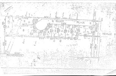
Map - Photocopy of Subdivision, Nine numbered allotments on Elliot Place off New Street, north of Palmerston Road, Ringwood, Victoria - 1971
... , north of Palmerston Road, Ringwood, Victoria - 1971. Map ... -
 Lakes Entrance Historical Society
Map - Shire of Tambo Lakes Entrance
Streets and subdivisions of Lakes Entrance. 2 pagestownships, waterways, roads and streets