Showing 1854 items matching "subdivisions"
-
 Kew Historical Society Inc
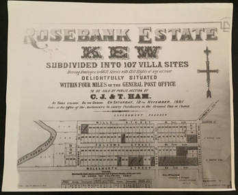
Plan - Subdivision Plan, Rosebank Estate, Kew
This work forms part of the collection assembled by the historian Dorothy Rogers, that was donated to the Kew Historical Society by her son John Rogers in 2015. The manuscripts, photographs, maps, and documents were sourced by her from both family and local collections or produced as references for her print publications. Many were directly used by Rogers in writing ‘Lovely Old Homes of Kew’ (1961) and 'A History of Kew' (1973), or the numerous articles on local history that she produced for suburban newspapers. Most of the photographs in the collection include detailed annotations in her hand. The Rogers Collection provides a comprehensive insight into the working habits of a historian in the 1960s and 1970s. Together it forms the largest privately-donated collection within the archives of the Kew Historical Society.Rosebank Estate (Kew). A photographic reproduction of a plan in the Vale Collection of the State Library of Victoria made for the historian Dorothy Rogers. This plan is a later version of the original subdivision plan after a number of lots had been sold.rosebank estate (kew), studley park, thomas ham, c.j. & t. ham, rosebank estate, kew, wills street, barry street, fellows street, redmond street, molesworth street, thomas wills, wills family -
 Kew Historical Society Inc
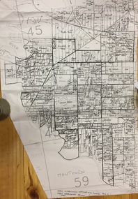
Plan, Gwen McWilliam, Annotated Plan of Kew & Hawthorn, 1993
Gwen Barton McWilliam (nee: Nelson), OAM, BA (1933- ). Gwen McWilliam is well known as an authority on the history of Boroondara and the author of a large number of books and pamphlets about the City. She was awarded the medal of the Order of Australia in 2001 ‘for service to the community of Hawthorn and district, particularly through the research, documentation and publication of its history.’ Plan of Kew and Hawthorn, forming part of a larger plan of the City of Boroondara, including annotations by the historian Gwen McWilliam, identifying significant landholdings, subdivisions and key dates. The plan was donated to the Kew Historical Society by Ms McWilliam. city of boroondara, subdivisions - hawthorn, subdivisions - kew, gwen mcwilliam -
 Ringwood and District Historical Society
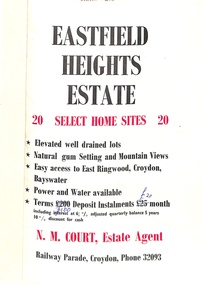
Flyer, Land Sale Brochure, Eastfield Heights Estate, Croydon. (Undated, circa 1950s)
Bi-fold advertisement for 20 residential allotments with locality map of East Ringwood-Croydon area and map of subdivision bounded by Eastfield Road, and The Pass, Croydon. Agent - N.M. Court, Railway Parade, Croydon, Phone 32093. -
 Phillip Island and District Historical Society Inc.
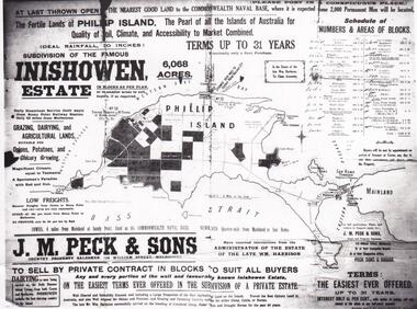
Map & Newspaper clipping, The Argus, Inishowen Estate, c1910 and 3/11/1868
Selection of land on Phillip island. Early subdivision of "Inishowen" Estate.449-01: Map of Phillip island showing "Inishowen" Estate c 1910 449-02: Newspaper article on the selection of land plus listing of people who obtained land. Argus 03/11/1868.inishowen estate phillip island, phillip island land selection 1868 -
 Greensborough Historical Society
Slide - Photograph, John Ramsdale, Riverside: Slide 1, 1990s
Photograph shows a new land subdivision, with the name "Riverside" on a wall.Part of the John Ramsdale collection of slides and audio visual material.Colour photograph scanned from slide.No maker's marks or captions -
 Greensborough Historical Society
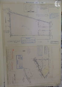
Planning document, Subdivision Plan #1128. St Helena Road Greensborough, 1985_
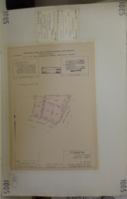
Plan of Subdivision for property at St Helena Road. (superseded plan)An example of hard copy subdivision plans from the Greensborough area. Mainly from the Shire of Diamond Valley era (1964-1994).Plan (2 sheets) mounted on heavy card.Stamped and handwritten Council permissions, dates and other details. Notation: 'Superseded plan see G1190'subdivision plans, st helena road -
 Greensborough Historical Society
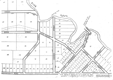
Maps, Greensborough. Parish Plan 1860, 1860c
This plan show Green's subdivision of Greensborough, north of Grimshaw Street.Enlargements of Parish plan circa 1860?One copy possibly from 1860, containing lot numbers for a government road, now Main Street, and surrounding streets.greensborough, grimshaw street greensborough, edward bernard green -
 Kew Historical Society Inc
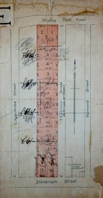
Plan - Subdivision Plan, Thornton Estate, 1918
The ‘Thornton Estate’ was the final subdivision of ‘Thornton’ in Studley Park Road. Thomas Cubitt Balmain originally owned Thornton, next to John Carson’s ‘Clutha’. Before its final subdivision, the Thomson family owned it. The Estate was a subdivision of 15 residential allotments running between Studley Park Road and Stevenson Street. The allotments faced these streets as well as Thornton Street, which the vendor undertook to make. Contemporary newspaper advertisements advised that ‘The estate possesses many advantages, notably its private and secluded, though convenient, position, splendid frontages and depths, and being close to the electric tram and Kew train, also within easy walking distance of the Victoria-street cable tram’. The terms offered purchasers were ten per cent deposit, with the balance to be paid in ten equal half-yearly payments at a rate of 5 per cent.subdivsion plans - kew, studley park, thornton estate -
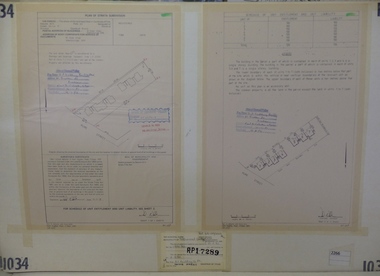 Greensborough Historical Society
Planning Document, Subdivision Plan #1034. 50 Hume Street, 03/02/1982
Plan of Strata Subdivision at 50 Hume Street Greensborough for 7 units.An example of hard copy subdivision plans from the Greensborough area. Mainly from the Shire of Diamond Valley era (1964-1994).Plan (2 sheets) mounted on heavy card.Stamped and handwritten Council permissions, dates and other details.subdivision plan -
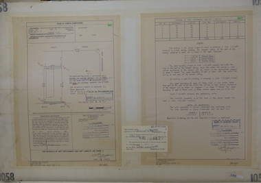 Greensborough Historical Society
Planning Document, Subdivision Plan #1058. Wattle Drive Watsonia, 14/07/1983
Plan of Strata Subdivision at 6 Wattle Drive Watsonia for 6 units.An example of hard copy subdivision plans from the Greensborough area. Mainly from the Shire of Diamond Valley era (1964-1994).Plan (3 sheets) mounted on heavy card.Stamped and handwritten Council permissions, dates and other details.subdivision plans, wattle drive watsonia -
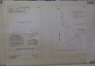 Greensborough Historical Society
Planning Document, Subdivision Plan # 1060, 8 Ulmara Place Greensborough, 20/04/1983
Plan of Strata Subdivision at 8 Ulmara Place Greensborough for 2 houses.An example of hard copy subdivision plans from the Greensborough area. Mainly from the Shire of Diamond Valley era (1964-1994).Plan (3 sheets) mounted on heavy card.Stamped and handwritten Council permissions, dates and other details.subdivision plans, ulmara place -
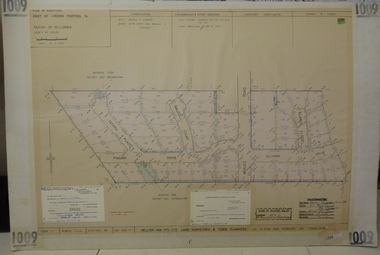 Greensborough Historical Society
Planning document, Subdivision Plan #1009. Corner Allumba Drive and Beales Road Greensborough, 1981_
Plan of Subdivision of land at corner of Allumba Drive and Beales Road Greensborough.An example of hard copy subdivision plans from the Greensborough area. Mainly from the Shire of Diamond Valley era (1964-1994).Plan (2 sheets) mounted on heavy card.Stamped and handwritten Council permissions, dates and other details.subdivision plans, allumba drive, beales road -
 Greensborough Historical Society
Planning document, Subdivision Plan #1005. Corner Douglas Court and Glen Katherine Drive Greensborough, 1981_
Plan of Subdivision. Corner Douglas Court and Glen Katherine Drive Greensborough.An example of hard copy subdivision plans from the Greensborough area. Mainly from the Shire of Diamond Valley era (1964-1994).Plan (2 sheets) mounted on heavy card.Stamped and handwritten Council permissions, dates and other details.subdivision plans, douglas court, glen katherine drive -
 Lakes Entrance Historical Society
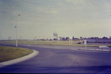
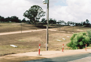
Photograph, Holding M, 2006
Property and subdivision believed to have been done by Bill and Kaye Reddenbach.Colour photograph of early stage of residential development showing roadways formed through property, drainage pipes placed ready for installation, street lighting in place. Photograph taken from school, looking east. Swan Reach Victorialand development, housing -
 Greensborough Historical Society
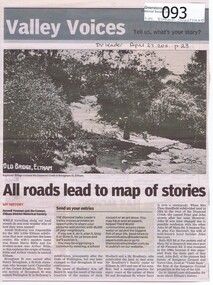
Newspaper - Newspaper clipping, All roads lead to map of stories, 27/04/2011
Family history of Josiah Holloway, origins of street names in the subdivision of Eltham History of Eltham and origins of street names connected with pioneers of the area.Newsprint, gray scale. Photograph of Keylock's Bridge on Diamond Creek at ElthamDV Leader April27 2011, p23josiah holloway, jack shallard, susanna maria bible, bradbury, henry brougham, handfield, fay harcourt, violet bank, kangaroo ground, bells hillroad, shalbury avenue, beard street, brougham street, main road, eltham -
 Glenelg Shire Council Cultural Collection
Administrative record - Administrative record - Proposed Heritage Valley Subdivision, 15/04/1992
Two lined sheets of paper, Elder's Real Estate logo top left, photocopies. Contain lists of lot numbers, area and price of blocks in proposed Heritage Valley subdivision. a) is an updated list and b) a further updated list -
 Bendigo Historical Society Inc.
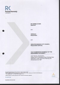
Document - Gemma Starr collection - Bendigo East Primary School - VCAT submission for the hearing of Ms. Gemma Starr vs Terraco and the Greater Bendigo City Council regarding the subdivision of the former Bendigo East PS site
Gemma Starr collection - Bendigo East Primary School - documents supporting the VCAT submission for the hearing of Ms. Gemma Starr vs Terraco and the Greater Bendigo City Council regarding the subdivision of the former Bendigo East PS site.social, local history, bendigo east primary school, planning obiections -
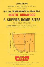 Ringwood and District Historical Society
Flyer, Land Auction, Cnr Warrandyte and Oban Roads, North Ringwood, Vic. - 1974
Single yellow page advertising Auction of five home sites to be sold separately on Saturday, 11th May, 1974. Details include vendor terms, subdivision services, and location map (north-east corner of Warrandyte and Oban Roads).(Agent) Eric Weber & Co. Pty. Ltd., 148 Wellington Parade, East Melbourne, 3002, Phone: 416025, Mr Elliott A.H. 8577502. Later handwritten notation suggests vendor was possibly Country Roads Board (VicRoads) after completion of road widening works. -
 Kew Historical Society Inc
Plan - Subdivision Plan, 10 Fine Villa Sites: Ermington Estate, Kew Heights, ca. 1917
Pru Sanderson, in her groundbreaking ‘City of Kew Urban Conservation Study : Volume 2 - Development History’ (1988), summarised the periods of urban development and subdivisions of land in Kew. The periods that she identified included 1845-1880, 1880-1893, 1893-1921, 1921-1933, 1933-1943, and Post-War Development. These periods were selected as they represented periods of rapid growth or decline in urban development. An obvious starting point for Sanderson’s groupings involved population growth and the associated economic cycles. These cycles also highlighted urban expansion onto land that was predominantly rural, although in other cases it represented the decline and breakup of large estates. A number of the plans in the Kew Historical Society’s collection can also be found in other collections, such as those of the State Library of Victoria and the Boroondara Library Service. A number are however unique to the collection.The Kew Historical Society collection includes almost 100 subdivision plans pertaining to suburbs of the City of Melbourne. Most of these are of Kew, Kew East or Studley Park, although a smaller number are plans of Camberwell, Deepdene, Balwyn and Hawthorn. It is believed that the majority of the plans were gifted to the Society by persons connected with the real estate firm - J. R. Mathers and McMillan, 136 Cotham Road, Kew. The Plans in the collection are rarely in pristine form, being working plans on which the agent would write notes and record lots sold and the prices of these. The subdivision plans are historically significant examples of the growth of urban Melbourne from the beginning of the 20th Century up until the 1980s. A number of the plans are double-sided and often include a photograph on the reverse. A number of the latter are by noted photographers such as J.E. Barnes.In November 1917, the Ermington Estate was advertised as an ‘Executor’s Sale’. It included the 10-roomed villa residence, ‘Ermington’, home of the late Mrs. Lorimer, and 10 ‘magnificent allotments’. The plan in the Kew Historical Society Collection is a little more specific. Ermington is described as having 9 Rooms &c. and there are 11 lots shown on the west side of Hillcrest Avenue. In the plan, the latter is named as ‘Hill Crest Avenue’. The plan indicates that the subdivision was based on the surveying work of Johnson & Tait. Opposite Ermington, the existing house ‘Parkhill’ is identified. A faded stamp on two parts of the plan indicates that it was in the possession of Jas. [R.] Mathers, Financial Agent, [136] Cotham Road, Kew.subdivision plans - kew, ermington heights estate - kew heights -
 Greensborough Historical Society
Planning Document, Subdivision Plan # 1016. Corner Weidlich and St Clems Roads Greensborough, 05/10/1981
Plan of Subdivision of land at corner of Weidlich Road and St Clems Road Greensborough.Plan (2 sheets) mounted on heavy card.Stamped and handwritten Council permissions, dates and other details.subdivision plans, weidlich road -
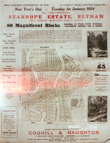 Eltham District Historical Society Inc
Negative - Photograph, Coghill & Haughton, Stanhope Estate, Eltham; great suburban subdivisional auction, New Year's Day - Tuesday 1st January 1924, 1923
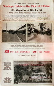
Subdivision of Stanhope property into 80 blocks; auction sale 1 Jan 1924 Roll of 35mm colour negative film, 3 stripsKodak CL 200 5093butcher, coghill and haughton, eltham, eltham railway station, railway station, real estate agent, stanhope estate, stanhope house -
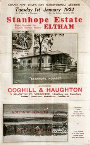 Eltham District Historical Society Inc
Negative - Photograph, Coghill & Haughton, Stanhope Estate, Eltham; great suburban subdivisional auction, New Year's Day - Tuesday 1st January 1924, 1923
Subdivision of Stanhope property into 80 blocks; auction sale 1 Jan 1924 Roll of 35mm colour negative film, 3 stripsKodak CL 200 5093butcher, coghill and haughton, eltham, eltham railway station, railway station, real estate agent, stanhope estate, stanhope house -
 Ringwood and District Historical Society
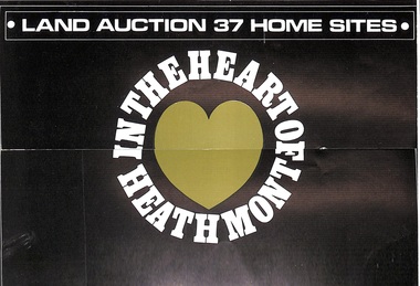
Pamphlet, Land Auction Brochure - Heathmont Hills Estate, Heathmont, Vic
Multi-fold brochure advertising auction of 37 home sites on Saturday May 6th, (1967?). Brochure includes terms of sale, description of subdivision features and local facilities, with locality map. Subdivision includes Canterbury Road, Cuthbert Street, and Craig Court, off Balfour Avenue, Heathmont. Agent - N.R. Reid & Co Pty Ltd., 173 Coleman Parade, Glen Waverley, (phone) 560 0355 A.H. 28 3185, in conjunction with H.G. McLean Pty Ltd., 166 Canterbury Road, Heathmont, 87 7808 A.H. 842 2708. -
Glen Eira Historical Society
Plan - Ristori
Real Estate leaflet for the subdivision sale of the Ristori Estate & Residence on 31/05/1919 by Yeo, Crosthwaite & Co. A map of the 24 subdivisions available plus a locality plan are included along with details of separate sale on 04/06/1919 of the weatherboard buildings, rooms, stables & glass house.house names, 'ristori', land sales, sewerage, glen eira road, brick houses, land subdivision, orrong road, glasshouses, yeo crosthwaite & co melbourne, ripponlea, stables, ristori estate, auctions, drainage, liscard street, st. georges road, balaclava road, glen huntly road, glenhuntly road, elsternwick station, hotham street, weatherboard buildings, elsternwick -
 Ballan Shire Historical Society
Map - Map. Shire of Ballan, Shire of Ballan
This is a fairly comprehensive map of the former Shire of Ballan which is now amalgamated into the Shire of Moorabool.A black and white map of the Shire of Ballan showing major roads, rivers, towns, settlements, State parks and forests and land subdivisions. It appears to be a copy of the original as no dates or maker or printer appear on the map. There is a scale of 2 miles to 1 inch.gordon, ballan, bungal, kerrit bareet, borhoneyghurk, bungeeltap, ballark, yaloak, gorong, beremboke, wallace, ingliston, hunterston, millbrook, bradshaw, myrniong, blackwood, moorarbool, greendale, bayup, trentham, bullarto, korweinguboora, glenlyon, bolwarra -
 Whitehorse Historical Society Inc.
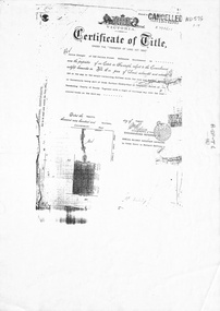
Legal record - Document, Forest Hill, 12/08/1913
Photocopy of Certificate of Title. Vol 3715 Fol. 742903 to Julius Draeger, 12 August 1913, for fifteen acres of land being part of Crown Portion 94, including plan of subdivision (P72294) cancelling title. [Contract of Sale ND567]Photocopy of Certificate of Title. Vol 3715 Fol. 742903 to Julius Draeger, 12 August 1913, for fifteen acres of land being part of Crown Portion 94, including plan of subdivision (P72294) cancelling title. [Contract of Sale ND567]Photocopy of Certificate of Title. Vol 3715 Fol. 742903 to Julius Draeger, 12 August 1913, for fifteen acres of land being part of Crown Portion 94, including plan of subdivision (P72294) cancelling title. [Contract of Sale ND567]glebe street, forest hill, land subdivision, draeger, carl julius otto, vicki street, bindy street, lee-ann street -
 Bendigo Historical Society Inc.
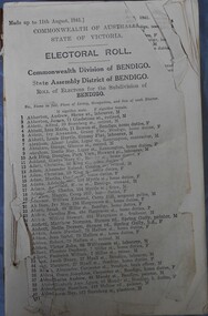
Administrative record - Electoral Roll, 1915
Voting registers, or electoral rolls, are a census of those who were eligible to vote. They are valuable because a country-wide census wasn't taken until 1911. Early electoral rolls give an individual’s name, residence, status of property occupation/ownership, and the rate value of the property. Electoral rolls are arranged by electoral district and subdistrict. Electoral rolls were published by each state during election years.. Commonwealth of Australia Electoral Roll, State of Victoria, Division of Bendigo, 1941. Roll of electors for the Commonwealth Division of Bendigo, State Assembly of Bendigo and Roll of electors for the Subdivision of Bendigo. Includes Name, Address, Occupation and gender. Assembled and fastened with string.electoral rolls, voting in bendigo -
 Bendigo Historical Society Inc.
Administrative record - Electoral Roll, 1915
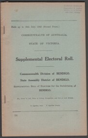
Voting registers, or electoral rolls, are a census of those who were eligible to vote. They are valuable because a country-wide census was not taken until 1911. Early electoral rolls give an individual’s name, residence, status of property occupation/ownership, and the rate value of the property. Electoral rolls are arranged by electoral district and subdistrict. Electoral rolls were published by each state during election years. Supplemental Electoral Roll for the Commonwealth Division of Australia Electoral Roll, State Assembly District of Bendigo, and Supplementary Roll of Electors for the Subdivision of Bendigo, 1943 (made up to July1943). Includes Name, Address, Occupation and gender. Assembled and bound with string.Stamp of owner Harold Curnowelectoral rolls, voting in bendigo -
 Bendigo Historical Society Inc.
Administrative record - Electoral Roll, 1915
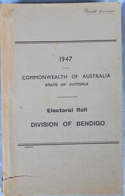
Voting registers, or electoral rolls, are a census of those who were eligible to vote. They are valuable because a country-wide census was not taken until 1911. Early electoral rolls give an individual name, residence, status of property occupation/ownership, and the rate value of the property. Electoral rolls are arranged by electoral district and subdistrict. Electoral rolls were published by each state during election years... Supplemental Electoral Roll for the Commonwealth Division of Australia Electoral Roll, State Assembly District of Bendigo, and Supplementary Roll of Electors for the Subdivision of Bendigo, 1947. Includes Name, Address, Occupation and gender. Assembled and bound with staples, grey/brown cover.Stamp of owner Harold Curnowelectoral rolls, voting in bendigo