Showing 652 items
matching survey department
-
 Stawell Historical Society Inc
Map, T.F. McGauran, Winjallock County of Kara Kara, 1900
... Photo Lithographed and the department of Lands & Survey... and the department of Lands & Survey, Melbourne by T.F. McCauran 22.10.00 A2 ...Noth of Navarre and BarkleyA2 Map0f Parish of Kara Kara.Photo Lithographed and the department of Lands & Survey, Melbourne by T.F. McCauran 22.10.00survey -
Stawell Historical Society Inc
Map - Parish Map, Department of Lands and Survey, Ashens County of Borung 1941, 1941
... Drawn and Reproduced at the department of Lands and Survey...Department of Lands and Survey... at the department of Lands and Survey Melbourne 1.5.1941 Paper Brown ...Murtoa Lake MarmaPaper Brown Coloured MapDrawn and Reproduced at the department of Lands and Survey Melbourne 1.5.1941survey -
Stawell Historical Society Inc
Map, Department of Crown Lands and Survey Victoria, Allotments in the Township of Banyana. Parish of Burrum Burrum. 1946 / 1971, 1971
Richardson River. Avon River JunctionPaper Map of County of BorungReprint of the 1946 edition. Drawn and reproduced at the Department of Crown Lands and Survey Victoria 1971.survey -
Stawell Historical Society Inc
Map, Department of Lands & Survey J. Noone, Township of Heatherlie. Parish of Baroka. County of Borung 1888, 1888
... photo Lithographed at the Department of lands and Survey...Department of Lands & Survey J. Noone... Lithographed at the Department of lands and Survey Melbourne By J Noone ...Stawell & Grampians Freestone Quarry Company Railway Reserve. Cross & masons Quarry Site. Mamnager'sHouse, Stead's boarding House Stawell and Grampians railwaySurveyed Township Showing Quarry and railway Reservephoto Lithographed at the Department of lands and Survey Melbourne By J Noone 15.6.88railway quarry -
Stawell Historical Society Inc
Map, Department of Lands and Survey, Borough of Stawell. Parishes of Stawell and Illawarra 1903, 1903
... Photo Lithograped at the Department of Lands and survey...Department of Lands and Survey... at the Department of Lands and survey Melbourne by T.F. McGauran 13.6.03 A0 ...Victoria Co., St Georges Co., Wimerra Co., Leviathon Co. Tramway, Quarry reserve, Newington Co., Galatea Co., Moonlight Co., Federal Co., Borough reservior., A0 Map of Stawell on linen backing. Plus one Printed on PaperPhoto Lithograped at the Department of Lands and survey Melbourne by T.F. McGauran 13.6.03surevy -
Whitehorse Historical Society Inc.
Document, Department of Crown Lands and Survey, 1983
Research guide of historical resources of the Department of Crown Lands and Survey. Compiled by P. Cabena, Aug 1983Research guide of historical resources of the Department of Crown Lands and Survey. Compiled by P. Cabena, Aug 1983Research guide of historical resources of the Department of Crown Lands and Survey. Compiled by P. Cabena, Aug 1983crown land, land surveys, victorian government -
Whitehorse Historical Society Inc.
Document, Annual Report, 1968
Annual Report of the Place Names Committee of Victoria for the year ended 30 June 1968. Department of Crown Lands and Survey.Annual Report of the Place Names Committee of Victoria for the year ended 30 June 1968. Department of Crown Lands and Survey.Annual Report of the Place Names Committee of Victoria for the year ended 30 June 1968. Department of Crown Lands and Survey.crown lands, victorian government, victoria. place names committee -
Whitehorse Historical Society Inc.
Map, Aerial photographs Nunawading, 1972
... and Survey, Melbourne, 1972. Department of Crown Lands and Survey ...Department of Crown Lands and Survey, Melbourne, 1972.Department of Crown Lands and Survey, Melbourne, 1972. Project runs 34 - 39 - City of Nunawading. frames numbered from South to North boundaries, each strip numbered from West to east. The series extends further West to Box Hill and East to Ringwood than the 1970 project. No index map. Sheets 39/2 and 34/28 missing.non-fictionDepartment of Crown Lands and Survey, Melbourne, 1972.victoria. department of crown lands and survey, aerial photographs, nunawading, mitcham, blackburn, blackburn north, blackburn south, forest hill, vermont, burwood east, box hill, ringwood, vermont south -
Whitehorse Historical Society Inc.
Map, Aerial photographs Nunawading, 1976
... . Department of Crown Lands and Survey Aerial Photographs Nunawading ...Department of Crown Lands and Survey, Melbourne, 1976 Project.Department of Crown Lands and Survey, Melbourne, 1976 Project. Runs 29 - 33 City of Nunawading. Frames numbered from South to North boundaries, each strip numbered from West to East. No index map. Sheets 30/8 and 30/9 missing.non-fictionDepartment of Crown Lands and Survey, Melbourne, 1976 Project. victoria. department of crown lands and survey, aerial photographs, nunawading, mitcham, blackburn, blackburn north, blackburn south, forest hill, vermont, vermont south, burwood east, box hill, ringwood -
Whitehorse Historical Society Inc.
Map, M.M.B.W, c1962
... Victoria. Department of Lands and Survey...Prepared by Department of Lands and Survey and Melbourne... by Department of Lands and Survey and Melbourne and Metropolitan Board... Mitcham melbourne Prepared by Department of Lands and Survey ...Melbourne Metropolitan Area Base Map series sheet 235, covering part, Mitcham, Nunawading and Ringwood areas.Melbourne Metropolitan Area Base Map series sheet 235, covering part, Mitcham, Nunawading and Ringwood areas. Prepared by Department of Lands and Survey and Melbourne and Metropolitan Board of Works from State aerial Survey, June 1957 and Cadastral Survey information, August 1960. Scale 1:4,800.Melbourne Metropolitan Area Base Map series sheet 235, covering part, Mitcham, Nunawading and Ringwood areas. maps, mitcham, nunawading, ringwood, melbourne and metropolitan board of works, victoria. department of lands and survey -
Whitehorse Historical Society Inc.
Map, Melbourne and suburbs, 1923
... at the Department of Lands and Survey, Melbourne by E. S. Hilcke, March 1923... at the Department of Lands and Survey, Melbourne by E. S. Hilcke, March 1923 ...Section of map 'Melbourne and Suburbs' compiled at the Department of Lands and Survey, Melbourne by E. S. Hilcke, March 1923, reprinted 1940.Section of map 'Melbourne and Suburbs' compiled at the Department of Lands and Survey, Melbourne by E. S. Hilcke, March 1923, reprinted 1940. Scale 40 chains: 1 inch. - Shire of Blackburn and MitchamSection of map 'Melbourne and Suburbs' compiled at the Department of Lands and Survey, Melbourne by E. S. Hilcke, March 1923, reprinted 1940.department of lands and surve, melbourne and suburbs -
Whitehorse Historical Society Inc.
Map, Blackburn East Primary School
Proposed master plan 1955?Proposed master plan 1955? With Public Works Dept. detail survey 1979. Rolled map.Proposed master plan 1955? blackburn east primary school no. 4800, public works department -
Whitehorse Historical Society Inc.
Document, EastLink, 2005-2008
Miscellaneous brochures, newsletters and notices distributed to local residents about aspects of the construction of the EastLink tollway.Miscellaneous brochures, newsletters and notices distributed to local residents about aspects of the construction of the EastLink tollway. Includes partial runs of EastLink News March 2005-June 2008, EastLink Construction Update December 2005-February 2008, and Community Connect Forum papers and Property Condition Survey Report for 7 May Court Mitcham.Miscellaneous brochures, newsletters and notices distributed to local residents about aspects of the construction of the EastLink tollway. may court, mitcham, no. 7, freeways, roads and streets, seita, thiess john holland, vicroads, victoria. department of infrastructure, mitcham frankston project. community connect forums -
 Whitehorse Historical Society Inc.
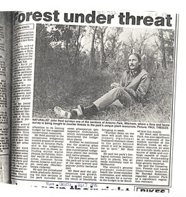
Article, Forest under threat, 13/09/1986 12:00:00 AM
An article in the Nunawading Gazette, naturalist John Reid has asked Council to commission a survey of flora and fauna of Antonio Park, Mitcham before this significant bushland remnant is impossible to save.native plants, antonio park, mitcham, reid, john, robinson, randall, victoria. department of conservation forests and lands -
 Rutherglen Historical Society
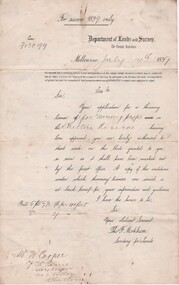
Document - License to thin trees, 1899 (Exact)
... "Department of Lands and Survey. On Forest Business"...Secretary for Lands, Department of Lands and Survey / On... cooper family forestry chiltern reserve "Department of Lands ...Dated July 14th 1899. Sent to Mr W. Cooper / c/o Mr Barrie / Storekeeper / No. 2 Valley / Chiltern / "Copy of Land Act 1896 / Regulations. Chapter XI Thinning Licenses"Document on stiff paper. Letter to Mr W. Cooper granting license to thin trees on a block of land at Chiltern Reserve. On back, copy of Land Act Regulations 1890"Department of Lands and Survey. On Forest Business"license, timber felling, cooper family, forestry, chiltern reserve -
 Department of Health and Human Services
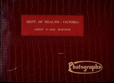
Photograph, Photo of photograph album cover entitled "Dept. of Health Victoria - Chest X-Ray Surveys - Photographs", 1962
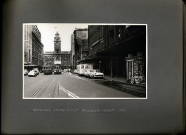
Part of an estray collection of material from the former Tuberculosis Branch.Leather bound photograph album containing 41 black and white photographsMain Entrance Melbourne Town Hall -
 Department of Health and Human Services
Photograph, Tuberculosis Branch - Chest X-Ray Surveys program - Photograph Album
-
 Department of Health and Human Services
Photograph, Tuberculosis Branch - Chest X-Ray Surveys program - Photograph Album
-
 Department of Health and Human Services
Photograph, Tuberculosis Branch - Chest X-Ray Surveys program - Photograph Album
Photo from Accession AS/14/612 -
 Department of Health and Human Services
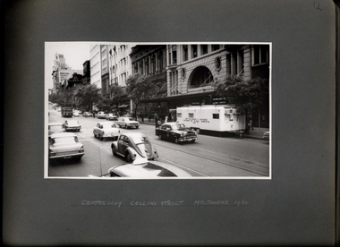
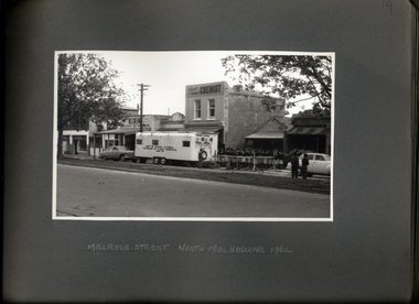
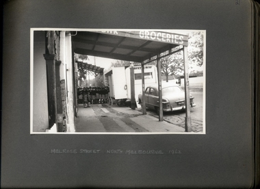
Photograph, X-ray caravan in Melrose St North Melbourne - Department of Health - Tuberculosis Branch - Chest X-Ray Surveys program - Photograph Album
Photo from Accession AS/14/612 -
 Department of Health and Human Services
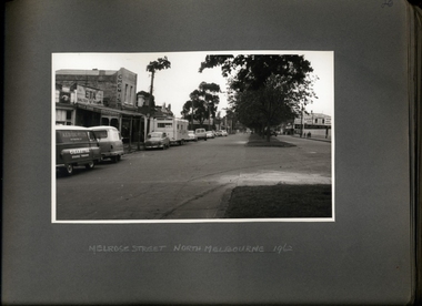
Photograph, School girls queuing at x-ray caravan on Melrose St North Melbourne - Department of Health -Tuberculosis Branch - Chest X-Ray Surveys program - Photograph Album
Photo from Accession AS/14/612 -
 Department of Health and Human Services
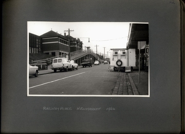
Photograph, X-ray caravan at Railway Place Newmarket - Department of Health - Tuberculosis Branch - Chest X-Ray Surveys program - Photograph Album
Photo from Accession AS/14/612 -
 Department of Health and Human Services
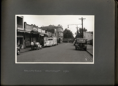
Photograph, Railway Place Newmarket - Department of Health - Tuberculosis Branch - Chest X-Ray Surveys program - Photograph Album
Photo from Accession AS/14/612 -
 Department of Health and Human Services
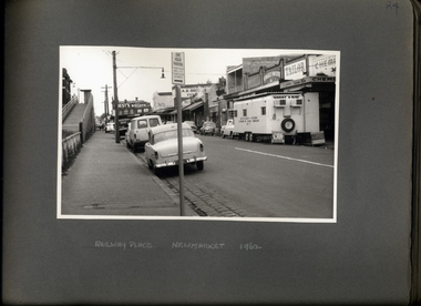
Photograph, Railway Place Newmarket - Department of Health - Tuberculosis Branch - Chest X-Ray Surveys program - Photograph Album
Photo from Accession AS/14/612 -
 Department of Health and Human Services
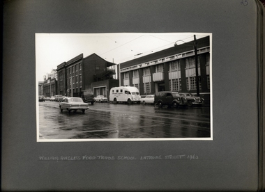
Photograph, Van Outside of the William Angliss Food Trade School La Trobe St - Department of Health - Tuberculosis Branch - Chest X-Ray Surveys program - Photograph Album
Photo from Accession AS/14/612 -
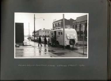 Department of Health and Human Services
Photograph, X-ray Van Outside of the William Angliss Food Trade School La Trobe St 1962 - Department of Health - Tuberculosis Branch - Chest X-Ray Surveys program - Photograph Album
Photo from Accession AS/14/612 -
 Department of Health and Human Services
Photograph, X-ray Van Outside of the William Angliss Food Trade School La Trobe St 1962 - Department of Health - Tuberculosis Branch - Chest X-Ray Surveys program - Photograph Album
Photo from Accession AS/14/612 -
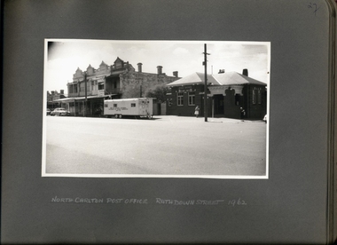 Department of Health and Human Services
Photograph, X-ray caravan Outside of the North Carlton Post Office Rathdowne St 1962 - Department of Health - Tuberculosis Branch - Chest X-Ray Surveys program
Photo from Accession AS/14/612 -
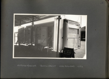 Department of Health and Human Services
Photograph, X-ray caravan Outside of the Victorian Markets Queen St 1962 - Department of Health - Tuberculosis Branch - Chest X-Ray Surveys program
Photo from Accession AS/14/612 -
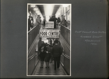 Department of Health and Human Services
Photograph, X-ray facility at Port Phillip Food Centre Flinders St 1962 - Department of Health - Tuberculosis Branch - Chest X-Ray Surveys program
Photo from Accession AS/14/612