Showing 2752 items matching "towers"
-
 Kew Historical Society Inc
Photograph - 'Fernhurst', 13 Fernhurst Grove, 1978
George Wharton arrived in Melbourne in 1844. An architect and surveyor, he was appointed to lay out the 'Village of Kew' by N.A. Fenwick following the land sales of 1851. A protagonist for Kew's separation from the Boroondara District Road Board, he was elected chairman when Kew achieved municipal status in December 1860. His home, 'Fernhurst', was built in 1866 on eight acres in Studley Park, with a four-storey tower and pyramidal roof. The Italianate home was a prominent Kew landmark. It was demolished in 1979 and replaced by St Paul's College in 1980.Rare colour photograph of what was once a significant mansion in Kew.Original colour positive photograph (Kodak print) of 'Fernhurst' in 1978. Photographed by Stewart West in May 1978, one year before it was demolished, the photograph gives little idea of the large landholding once surrounding the house. Originally accessed from near the corner of Princess Street and Studley Park Road, its gardens had been subdivided in the 1900s and its footprint restricted to 13 Fernhurst Grove. Like many other grand houses, by the 1970s it had been converted into apartments. From the photograph, one can see that the house had retained many of its original features such as the distinctive tower and the wide bow-fronted verandah. The slates on the roof (apart from those on the tower) had been replaced by tiles and the cement render of the exterior painted white. Annotated reverse: "Fernhurst from higher ground level side shot / 7"fernhurst, 13 fernhurst grove -- kew (vic.), george wharton, italianate architecture, vila maria society, st paul's school for the blind -
 Kew Historical Society Inc
Photograph - 'Fernhurst', 13 Fernhurst Grove, 1978
George Wharton arrived in Melbourne in 1844. An architect and surveyor, he was appointed to lay out the 'Village of Kew' by N.A. Fenwick following the land sales of 1851. A protagonist for Kew's separation from the Boroondara District Road Board, he was elected chairman when Kew achieved municipal status in December 1860. His home, 'Fernhurst', was built in 1866 on eight acres in Studley Park, with a four-storey tower and pyramidal roof. The Italianate home was a prominent Kew landmark. It was demolished in 1979 and replaced by St Paul's College in 1980.Rare colour photograph of what was once a significant mansion in Kew.Original colour positive photograph (Kodak print) of 'Fernhurst' in 1978. Photographed by Stewart West in May 1978, one year before it was demolished, the photograph gives little idea of the large landholding once surrounding the house. Originally accessed from near the corner of Princess Street and Studley Park Road, its gardens had been subdivided in the 1900s and its footprint restricted to 13 Fernhurst Grove. Like many other grand houses, by the 1970s it had been converted into apartments. From the photograph, one can see that the house had retained many of its original features such as the distinctive tower and the wide bow-fronted verandah. The slates on the roof (apart from those on the tower) had been replaced by tiles and the cement render of the exterior painted white. Annotated reverse: "Back view of Fernhurst / 8"fernhurst, 13 fernhurst grove -- kew (vic.), george wharton, italianate architecture, vila maria society, st paul's school for the blind -
 Kew Historical Society Inc
Photograph - 'Fernhurst', 13 Fernhurst Grove, 1978
George Wharton arrived in Melbourne in 1844. An architect and surveyor, he was appointed to lay out the 'Village of Kew' by N.A. Fenwick following the land sales of 1851. A protagonist for Kew's separation from the Boroondara District Road Board, he was elected chairman when Kew achieved municipal status in December 1860. His home, 'Fernhurst', was built in 1866 on eight acres in Studley Park, with a four-storey tower and pyramidal roof. The Italianate home was a prominent Kew landmark. It was demolished in 1979 and replaced by St Paul's College in 1980.Rare colour photograph of what was once a significant mansion in Kew.Original colour positive photograph (Kodak print) of 'Fernhurst' in 1978. Photographed by Stewart West in May 1978, one year before it was demolished, the photograph gives little idea of the large landholding once surrounding the house. Originally accessed from near the corner of Princess Street and Studley Park Road, its gardens had been subdivided in the 1900s and its footprint restricted to 13 Fernhurst Grove. Like many other grand houses, by the 1970s it had been converted into apartments. From the photograph, one can see that the house had retained many of its original features such as the distinctive tower and the wide bow-fronted verandah. The slates on the roof (apart from those on the tower) had been replaced by tiles and the cement render of the exterior painted white. Annotated reverse: "Fernhurst front view taken from across Fernhurst Grove / 6"fernhurst, 13 fernhurst grove -- kew (vic.), george wharton, italianate architecture, vila maria society, st paul's school for the blind -
 Kew Historical Society Inc
Photograph - 'Fernhurst', 13 Fernhurst Grove, 1978
George Wharton arrived in Melbourne in 1844. An architect and surveyor, he was appointed to lay out the 'Village of Kew' by N.A. Fenwick following the land sales of 1851. A protagonist for Kew's separation from the Boroondara District Road Board, he was elected chairman when Kew achieved municipal status in December 1860. His home, 'Fernhurst', was built in 1866 on eight acres in Studley Park, with a four-storey tower and pyramidal roof. The Italianate home was a prominent Kew landmark. It was demolished in 1979 and replaced by St Paul's College in 1980.Rare colour photograph of what was once a significant mansion in Kew.Original colour positive photograph (Kodak print) of 'Fernhurst' in 1978. Photographed by Stewart West in May 1978, one year before it was demolished, the photograph gives little idea of the large landholding once surrounding the house. Originally accessed from near the corner of Princess Street and Studley Park Road, its gardens had been subdivided in the 1900s and its footprint restricted to 13 Fernhurst Grove. Like many other grand houses, by the 1970s it had been converted into apartments. From the photograph, one can see that the house had retained many of its original features such as the distinctive tower and the wide bow-fronted verandah. The slates on the roof (apart from those on the tower) had been replaced by tiles and the cement render of the exterior painted white. Annotated reverse: "Fernhurst corner shot through trees / 12-22"fernhurst, 13 fernhurst grove -- kew (vic.), george wharton, italianate architecture, vila maria society, st paul's school for the blind -
 Nhill Aviation Heritage Centre
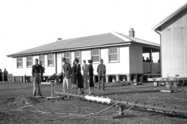
Black and white photograph, Local photograph. Original of this scan held by Nhill Historical Society, Aeradio Building c1937
This building is still intact at the Nhill Aerodrome. Some of the infrastructure is also in place or can be evidenced by its foundations.The Aeradio building was built on the present aerodrome in 1937. This was one of only sixteen buildings of this type built across Australia and it housed radio communications and guidance equipment. The building and its equipment were part of a comprehensive system of radio towers, signalling and meteorology equipment aimed at providing safer navigation for aircraft travelling throughout Australia. The facility closed in the 1960sThis photo is significant due to it having been taken soon after the building was constructed. It is the earliest known photograph taken on an open to the public day before the receiver aerials were erected.The Aeradio building was built on the present (2012) aerodrome in 1937 or 1938. This was one of only fifteen buildings of this type built across Australia and it housed radio communications and guidance equipment. The building and its equipment were part of a comprehensive system of radio towers lights and signalling equipment aimed at providing safer navigation for aircraft travelling throughout Australia. The facility closed in the 1960sphoto, aeradio, early, civil aviation, dca, dept of civil aviation -
 Glenelg Shire Council Cultural Collection
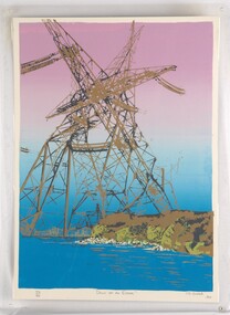
Print, Dawn of an Error, 1984
CEMA Art Collection. Part of "A Community View" 150 years in Portland Screenprint Exhibition. Part of Angela Gee Residency 1983 and 1984.Laminated screenprint of high tension electricity towers on top of coastline. The foreground shows the ocean with white rocks and the cliffs of the coastline in gold and various shades of green. The electricity towers are black and gold and printed on a purple and blue background.Front: 40/60 (lower left) "Dawn of an Error" (lower centre) CJ Snook '84 (lower right) (pencil) Back: 29 -
 Glenelg Shire Council Cultural Collection
Print, Dawn of an Error, 1984
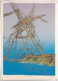
Laminated screenprint of high tension electricity towers on top of coastline. The foreground shows the ocean with white rocks and the cliffs of the coastline in gold and various shades of green. The electricity towers are black and gold and printed on a purple and blue background. -
 Glenelg Shire Council Cultural Collection
Photograph - Photograph - Main Breakwater Construction, n.d
Port of Portland Authority Archivesport of portland archives, portland harbour, tug trewalla berthed, battery point -
 Bendigo Historical Society Inc.
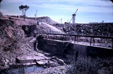
Slide - DAVID MCDONALD COLLECTION: EPPALOCK. CONSTRUCTION, c1963
Eppalock. Construction. Lake appears to be full or close to it with beautiful blue water. The bank to the left is the bank which the road goes across, the walkway out to the water tower and the water tower. Markings: Eppalock Dam March 1963.Kodakcivil engineering, water supply, eppalock -
 Queen Victoria Women's Centre
Photograph, August 1996
Colour photograph. Ground floor acing south west into QVWC tower in what was to be the cafe. Entrances show access corridors to ormer towers. New structure for roof seen with black tarp. Taken during restoration inspectionbuilding construction, historic buildings, cultural structures and establishments -
 Eltham District Historical Society Inc
Photograph, Laurie Richards, Group who attended Dinner to Aid Building Appeal for Austin Hospital, 21 Nov.1973
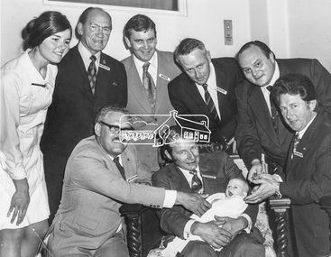
Austin Hospital Building Appeal: Group who attended Dinner, 21 Nov. 1973: Back Row (L-R): Sister Barbara Fitton, Cr. Ingersole, C.J. Brock (Shire Secretary, Eltham), J.A. McDonald (Shire Engineer, Eltham), Bruce Skegg, M.P., Chairmain, Board of Management, Austin Hospital. Front: P.J. Catchlove (Senior Adminsitrative Officer, Shire of Eltham), Cr. Horsley with Baby Alison Yagg of Watsonia, Cr. Clarke (Shire President). At this dinner P.J. Catchlove was made a Life Governor of the Austin Hospital.This photo forms part of a collection of photographs gathered by the Shire of Eltham for their centenary project book,"Pioneers and Painters: 100 years of the Shire of Eltham" by Alan Marshall (1971). The collection of over 500 images is held in partnership between Eltham District Historical Society and Yarra Plenty Regional Library (Eltham Library) and is now formally known as the 'The Shire of Eltham Pioneers Photograph Collection.' It is significant in being the first community sourced collection representing the places and people of the Shire's first one hundred years.Digital image Print 19.5 x 25 cm (Held at Eltham Library)Laurie Richards Pty. Ltd., 4 Tower Ave., Alphington Photo No. 73-2343austin hospital, heidelberg, sepp, shire of eltham pioneers photograph collection, appeal, fundraising, other areas, sister barbara fitton, cr. ingersole, c.j. brock, j.a. mcdonald, bruce skegg, p.j. catchlove, cr. horsley, baby alison yagg, cr. clarke, austin hospital appeal -
 Ringwood and District Historical Society
Photograph, Ringwood Clocktower dome retained from Warrandyte Road location being placed on new tower at Wantirna Road site - 1967
B&W photograph. See also VC 2397 for other images of the clocktower under constructionWritten on backing sheet, "Dome of old tower being placed on new one - 1967". -
Glenelg Shire Council Cultural Collection
Photograph - Sheet of 6 contact prints, 1964
Port of Portland Authority ArchivesFront: 20. 5-5-64 22. 5-5-64 21. 5-5-64 24. 5-5-64 23. 5-5-64 (In white, beneath each print). Back: 20 in pencilport of portland archives, k s anderson wharf -
 Glen Eira Historical Society
Historical Caulfield to 1972, photo album by Jenny O’Donnell, St Georges Rd
2 photos of number 63 an Edwardian attic house, veranda with portico, conical towerelsternwick, st georges rd, houses, edwardian house, o’donnell, jenny -
 Marysville & District Historical Society
Photograph (Item) - Colour photograph, Travel Victoria, 2006
A colour photograph of Murchison Street in Marysville in Victoria.A colour photograph of Murchison Street in Marysville in Victoria.murchison street, marysville, victoria, photograph -
Ringwood and District Historical Society
Document - Envelope, Packet: R.S.L. Thesis (Angela Lacey - HSC 1989) incl Ringwood R.S.L and Clocktower
Thesis including Ringwood RSL and Ringwood clock tower +Additional Keywords: Lacey, Angela -
 Federation University Historical Collection
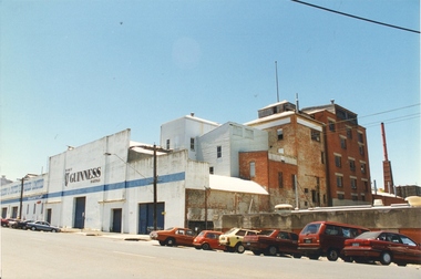
Photograph - Colour, Ballarat Brewery, Armstrong Street South, Ballarat
Ballarat Brewery, Armstrong Street South, Ballarat showing the old brick Brew Tower.ballarat brewery, brewery, brewing, brew tower -
Glenelg Shire Council Cultural Collection
Photograph - Photograph - Silo Construction, c. 1964
Port of Portland Authority ArchiveFront: 27 - in black ink Back: Blue PHT stampport of portland archives, silo construction -
 Bendigo Historical Society Inc.
Slide - BENDIGO & EASTER FAIR, 1963
Rosalind Park, view from lookout tower, over Camp Hill Primary School.slide, bendigo, rosalind park -
 Bendigo Historical Society Inc.
Slide - BENDIGO & EASTER FAIR, 1963
View from Rosalind Park tower looking over Camp Hill Primary School.slide, bendigo, city view -
 Bendigo Historical Society Inc.
Slide - DAVID MCDONALD COLLECTION: EPPALOCK. CONSTRUCTION, c1960
Eppalock. Construction. Construction of the water outlet under the wall of the dam, near the water tower.Agfacolorcivil engineering, water supply, eppalock -
 Bendigo Historical Society Inc.
Slide - CASTLEMAINE HISTORICAL SOCIETY COLLECTION, ROSALIND PARK, BENDIGO, 1955
Slides. View of Bendigo from Rosalind Park view from tower. Dated 28.5.55slide, bendigo, rosalind park, castlemaine historical society collection -
 Victorian Interpretive Projects Inc.
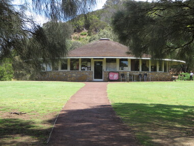
Photograph - Colour, Clare Gervasoni, Tower Hill Interpretation Centre by Robin Boyd, 2015, 25/12/2015
interpretation centre in the crater of Tower Hill near Koroit. The centre was designed by Robin Boyd.tower hill, tower hill interpretation centre, robin boyd -
 National Vietnam Veterans Museum (NVVM)
Photograph, Control Tower at Nui Dat Airfield
Framed colour Photograph of the Control Tower at Nui Dat (Luscombe) Airfield 1969-70photograph, nui dat, luscombe field, control tower, nui dat airfield -
 Uniting Church Archives - Synod of Victoria
Photograph, 1986
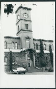
Hamilton and Western District Boys' College was established in 1872 as a private business. It was acquired by the Presbyterian Church in 1911, relinquished in 1919 and re-acquired by the Presbyterian Church of Victoria in 1956. It amalgamated with Alexandra College in the 1962. Alexandra College for Girls was opened in 1872 as a private school and taken over by the Presbyterian Church in 1954.B & W exterior view of the entrance and tower of Hamilton College, Chaucer St. Hamilton.hamilton college, hamilton and western district boys' college, alexandra college, presbyterian church of victoria -
 Rutherglen Historical Society
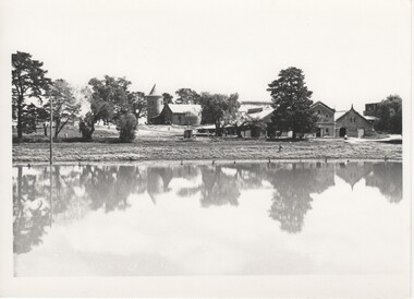
Image, Olive Codling
Some of the buildings of the Mount Ophir winery. Photo was taken by Miss Olive Codling, who was a life member of the Wodonga Historical Society. Photograph is believed to have been taken on the occasion of a Tour by the North East Branch, 1st combined meeting.Black and white photograph of a group of buildings, one with a tower, viewed across a body of water.mt ophir, mount ophir, wine industry -
 Rutherglen Historical Society
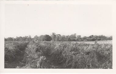
Image, 1970s
This was the site of some of the first vines that were planted in the Rutherglen grapegrowing area. It is no longer operating as a winery. Established in 1858, Gehrig's is the oldest family winery in Victoria.Black and white photograph with a view over a vineyard. Trees and building with a square tower in the backgroundOn back of photo: "Gehrig's"wineries, north east victoria, wine industry, gehrigs winery -
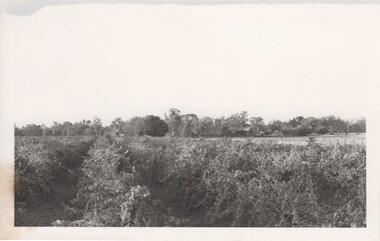 Rutherglen Historical Society
Image, 1970s
This was the site of some of the first vines that were planted in the Rutherglen grapegrowing area. It is no longer operating as a winery. Established in 1858, Gehrig's is the oldest family winery in Victoria.Black and white photograph with a view over a vineyard. Trees and building with a square tower in the backgroundwineries, north east victoria, wine industry, gehrigs winery -
 Ballarat Heritage Services
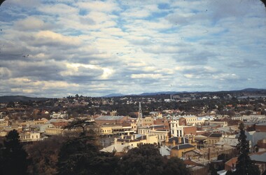
Photograph, Ballarat Looking North-east from the Town Hall Tower, 14/12/1895
Photograph published in the Australasian of Ballarat Looking North-east from the Town Hall Towerballarat, ballarat town hall, ballarat post office, ballarat railway station -
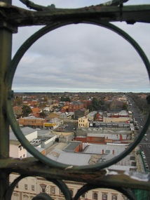 Ballarat Heritage Services
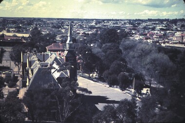
Photograph, L.J. Gervasoni, Ballarat from the Town Hall Tower, 2006, 14/06/2006
Ballarat looking toward St Patrick's Cathedral, from the Ballarat Town Hall tower. ballarat, aerial, ballarat town hall tower, st patrick's cathedral, sturt street