Showing 2416 items
matching townships
-
 Clunes Museum
Photograph
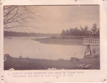
NEWLYN RESERVOIR - SUPPLIES WATER TO CLUNES TOWNSHIPSEPIA PHOTOGRAPH OF PART OF NEWLYN RESERVOIR - TREES SURROUNDING WATER EDGE. SMALL DANDING STRUCTURE ON RIGHT SIDE. BARE TREE BRANCHES ON LEFT SIDE OF PHOTOGRAPH.PART OF NEWLYN RESERVOIR ONCE OWNED BY CLUNES WATER COMMISSION AND SOLD TO S.R. & W.S.C. IN 1958local history, photography, photographs, water supply -
 Malmsbury Historical Society
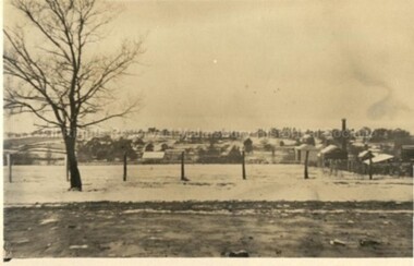
Postcard (Item), Postcard Snow In Malmsbury 1922 Kodak Postcard, Malmsbury 29/6/1922
Associated with - Kodak Postcard People - "Township, Houses" -
 Lakes Entrance Regional Historical Society (operating as Lakes Entrance History Centre & Museum)
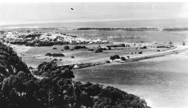
Postcard, Bulmer H D, 1950c
Township of Lakes Entrance from Jemmys PointBlack and white photograph of view from Kalimna Heights, showing part of the North Arm concrete bridge, Bullock Island and western side of entrance. Truck parked on approach to bridge. Lakes Entrance Victoriatownship, jetties, guesthouses, islands, hotels -
 Bendigo Military Museum
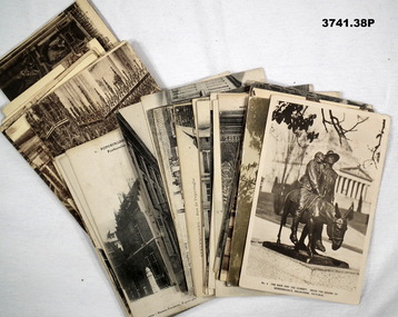
Photograph - POSTCARDS, PHOTOGRAPHIC, Unknown
Postcard photos of townships in France & Belgium 1914 - 1919.38 x sepia photo post cards. .1) Man & the Donkey Melbourne .2) Military funeral Australian .3) Porte de Neptune .4) - .5) Ypres .6) - .13) Aire-Sur-La-Lys .14) - .18) Steenwoorde .19) - .25) Poperinghe .26) - .38) Amiensmilitary funeral, ypres, aire-sur-la-lys, steenwoorde, poperinghe, amiens -
 Rutherglen Historical Society
Photograph - Image, 1949
Believed to be the Advance Australia Hotel, Great Northern township.Black and white photograph of a timber building, close to the edge of a road. Written on back of photo: "The Advance Aust. Hotel on Murray Valley H/way near Rutherglen. 1949"hotels, advance australia hotel, great northern -
 Hume City Civic Collection
Photograph
The woodland area was photographed on the outskirts of the old Sunbury township.The landscape featured in this image was typical of Sunbury's surrounds in the 19th and early years of the twentieth century. A copy of a non-digital black and white photograph of an woodland area. Two men with a horse and cart are visible in the image.VIEW OF SUNBURYhorses, drays, trees, c. nettleton -
 Sunbury Family History and Heritage Society Inc.
Photograph, 1935
The waterfall is in Jacksons Creek downstream from the Sunbury township.A black and white photograph with a cream border of a waterfall in a river. A gnarled tree is growing on the bank and there is a hill in the middle distance.waterfalls, jacksons creek, sunbury -
Clunes Museum
Book - ADMINSTRATIVE REPORT, JOHN TAYLOR & SON, REPORT ON THE CLUNES GOLD FIELD STATE OF VICTORIA, AUSTRALIA, 1935
WRITTEN REPORT OF JOHN TAYLOR AND SONS, LONDON OF THE EXAMINATION OF THE PROPOSAL TO REOPEN THE GOLD MINES SITUATED IN THE TOWNSHIP OF CLUNES...HARDCOVER BOOK CONTAINING REPORTS BY THE MINING REGISTRARS WITH MAPS OF THE CLUNES GOLD FIELDWRITTEN REPORT OF JOHN TAYLOR AND SONS, LONDON OF THE EXAMINATION OF THE PROPOSAL TO REOPEN THE GOLD MINES SITUATED IN THE TOWNSHIP OF CLUNES...gold mining, commercial report, clunes mines to reopen, 1935 -
 Kiewa Valley Historical Society
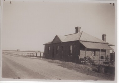
Papers - Hollonds' Family and their memories, 2013
The Hollonds' family were original settlers in the Kiewa Valley at Mulagong. Their descendants owned land in Tawonga, Tawonga South and between the East and West of the Kiewa river. Hollonds had a cattle run on Mt Fainter which was later given to the Hicks family.Members of the Hollonds family lived, worked and married in the Kiewa Valley. These papers describe the connection to the families and the Kiewa Valley.Typed papers donated by the Hollonds' family covering: The Hollonds Family History, Cattlemen, 'Snowy' Miller, Mrs Hollonds' Boarding house, SEC Depot at Tawonga, building of Bogong Township, Early Scenes on the Kiewa Scheme.hollonds family, tawonga station, cattlemen, mt beauty land, tawonga boarding house -
 Bendigo Military Museum
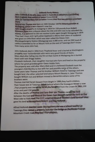
Photograph - PHOTOGRAPH, FRAMED
Tobruk panorama. Black plastic frame, glass front, white cardboard backing, black & white photograph with cream border. Photo in 5 sections showing Tobruk township & surrounding landscape of desert & military vehicles. LHS bottom front: Donation info sticker Centre front: Tobruk sticker Blue sticker on backing: Bendigo City Framersphotograpy - photographs, frame accessories, tobruk -
Federation University Historical Collection
Map, Town of Buninyong, 1927, 09/1927
The date of this map is September 1927 revised from the original 1910 map. Buninyong was created a district on 09 July 1858, proclaimed a Shire on 16 February 1864, and the Buninyong Borough united on 01 October 1915.Township plan of the Town of Buninyong showing government roads and crown allotments. Earlier detail pencilled on (commercial buildings, etc) appears to be from an 1850 survey. Scale: 4 chains to 1 inch (1:3168)buninyong, map, buninyong botanical gardens, tannery dam, buninyong reservoir, chapel school, rev. hastie -
Bendigo Historical Society Inc.
Map - CAMPBELL COLLECTION: BENDIGO AND DISTRICT MAPS, 1959
Map. Huntly, County of Bendigo, Neilborough, Bagshot, Nerring, Wellsford, Sandhurst. Township of Huntly. By Authority A.C. Brooks, Government Printer Melbourne. Drawn and reproduced at the Department of Lands and Survey, Melbourne, 1958. Price 5/-.A.C. Brooks, Government Printermap, bendigo, allotments -
 Clunes Museum
Photograph, KODAK, 1999
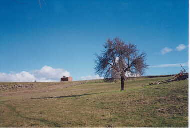
VIEW OF POWDER MAGAZINE USED IN MINING DAYS TO STORE EXPLOSIVES. BUILDING MATERIALS SOLID BRICKCOLOURED REPRINT PHOTOGRAPH OF POWDER MAGAZINE EXTERIOR. SITUATED IN A PADDOCK ON SMEATON ROAD APPROX. 2 KM. FROM TOWNSHIP ON LEFT HAND SIDE. LEAFLESS TREE IN FOREGROUND - FALLEN TREE BESIDE IT EASTERN ASPECT.local history, photography, photographs, mining -
Lakes Entrance Regional Historical Society (operating as Lakes Entrance History Centre & Museum)
Photograph, 1930 c
Black and white photograph taken from north of township looking toward town and front lake and sand dunes. Roadway in middle distance is Myers Street known as Allens Hill in 1930 Lakes Entrance Victoriatownship, roads and streets -
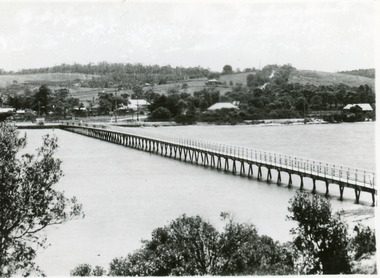 Lakes Entrance Regional Historical Society (operating as Lakes Entrance History Centre & Museum)
Postcard - Footbridge, 1937c
1 copy same|1 copy in poor condition- Mrs Helen Stokes|1 tinted copy. all same sizeBlack and white small format postcard of the footbridge over the Cunninghame Arm. It shows natural vegetation of the south shore in the foreground and residences and trees of the township and Myer Street ascending the hill in the background. Lakes Entrance Victoriawaterways, bridges, township -
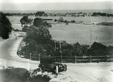 Lakes Entrance Regional Historical Society (operating as Lakes Entrance History Centre & Museum)
Photograph - Princes Highway Lakes Entrance, 1930c
Black and white photograph of the Princes Highway as it winds around Jemmys Point. It shows a car parked in foreground, person on bicycle riding up hill, lake, Bullock Island and the township in distance. Lakes Entrance Victoria transport, roads and streets, waterways, township -
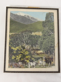 Kiewa Valley Historical Society
Photo Framed - Tawonga South, c1940's
Tawonga South was situated between the rural township of Tawonga and the State Electricity Commission of Victoria's construction town of Mt Beauty. The building in the fore ground of the photo was built before the Mt Beauty township was built as the occupier was working on the Kiewa Hydro Electric Scheme.The Barters came to work on the State Electricity Commission of Victoria's Kiewa Hydro Electric Scheme before housing in the town of Mt Beauty was built. The Barters rudimentary dwelling was probably not a legal building. The photo was taken by Vera Hore (nee Ryder), the publican at the Bogong Hotel near Tawonga South where the photo was taken. Vera, 1909 - 2000, was a keen amateur photographer.Colored photo of Tawonga South with a dwelling in the bottom of the right hand corner and Mt Bogong, covered in snow, at the top. Framed with cream card board 1 cm wide and a metal decorated frame surrounding it.On the back - "Vera Hore"tawonga south; vera hore; mt beauty -
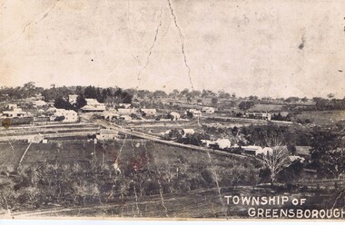 Greensborough Historical Society
Photograph - Digital Image, Greensborough township c1900, 1900s
This photograph shows a very rural Township of Greensborough around 1900.Digital copy of black and white photographmain street greensborough, greensborough -
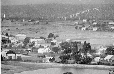 Stawell Historical Society Inc
Photograph, Stawell Township looking towards Wild Cat Hill 1880
Stawell Township looking towards Wild Cat Hill 1880stawell -
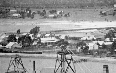 Stawell Historical Society Inc
Photograph, Panorama of Stawell Township taken from Big Hill
Stawell Township looking towards Wild Cat Hill 1880stawell -
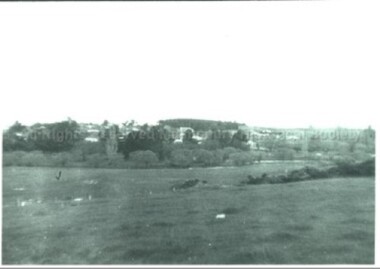 Malmsbury Historical Society
Photograph (Item), Malmsbury Township From Western Vantage Point, Malmsbury ca1950
People - Young Family Buildings - Township/Football Oval/Willows -
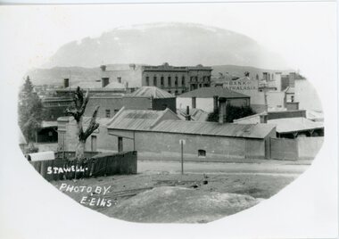 Stawell Historical Society Inc
Photograph, Upper Main Sstreet Stawell
B/W photo view of township upper main streetstawell -
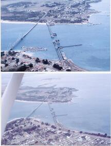 Phillip Island and District Historical Society Inc.
Photographs/Slides, Laurie Dixon, 1960's
Four of a collection of slides taken by Laurie Dixon. (Scanned by E Alexander) The new bridge was built in 1968.Four coloured photographs scanned from slides. Three aerial views. 273-01. Aerial view of the old and new bridges and Newhaven, San Remo and Churchill Island - extra close up of same photo. 273-02. Aerial view of the old and new bridges looking towards Cape Woolamai on the top right. 273-03. Aerial view of the Cowes Pier and township - extra close up of same photo. 273-04. Looking down the Cowes Pier towards the township with Isle of Wight Hotel in the background.273-03. Inscription on the slide: Cowes from the air Jan 1968.phillip island suspension bridge, two bridges phillip island, san remo, newhaven, laurie dixon, cowes pier, cowes pier phillip island -
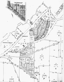 Ringwood and District Historical Society
Photograph, Parish Map - Township of Ringwood - 1890
Written on backing sheet, 'SLV Parish Map Collection. Vol.67, Fol. 43, 1890'. Catalogue card reads, 'SLV Parish Map Collection 1890. (Township of Ringwood). -
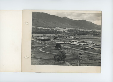 Kiewa Valley Historical Society
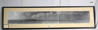
Photo - black & white - Mt Beauty Township, April 1948
Panorama of 'General View of Mt Beauty Township' SECV black & white photo dated 22 April 1948. This is the first of three photos that fold out and join to complete the panorama. (Note: the other two photos not included) -
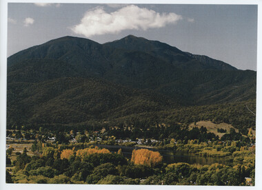 Kiewa Valley Historical Society
Photos - Mt Beauty Township and 'The Chalet'
Mt Beauty was built by the SECV to house the workers working on the Kiewa Hydro Electric Scheme.A. Colored photo of Mt Beauty Township in Autumn with Mount Bogong in the background. B. A long black and white photo attached to white cardboard with the title 'Staff accommodation Mt Beauty 1948-49' written below the photo.On the back in pencil 'Building "The Chalet" 1948-49'the chalet mt beauty -
 Bendigo Historical Society Inc.
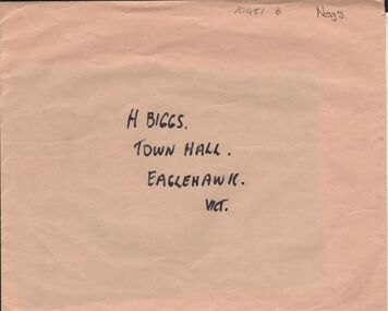
Negative - ALBERT RICHARDSON COLLECTION: EAGLEHAWK TOWNSHIP NEGATIVES
Envelope containing two negatives: on outside of envelope 'H. Biggs, Town Hall, Eaglehawk, Vict' on back 2 negatives, 1 township of Eaglehawk, 2. View from behind Eaglehawk Town Hall. Negatives not scanned.bendigo, streetscape, eaglehawk -
 Bendigo Historical Society Inc.
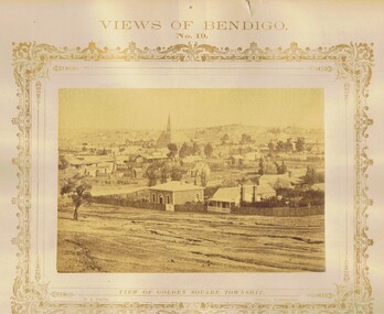
Photograph - VIEWS OF BENDIGO: GOLDEN SQUARE TOWNSHIP, c. 1870's
Photograph No. 19. Sepia photograph of view of Golden Square township. Church in centre back of view. Printed below photograph: Welch Type, Forbes & Holmes, Agents. Written on front MP148 (Two Copies) Nicholas CaireN J Caireplace, landscape view, golden square -
 Bendigo Historical Society Inc.
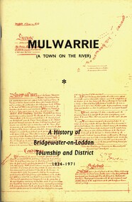
Book - MULWARRIE A TOWN ON THE RIVER A HISTORY OF BRIDGWATER-0N-LODDON TOWNSHIP AND DISTRICT 1836-1971, 1971
'Mulwarrie' (A Town on the River). A History of Bridgewater-on-Loddon Township and District 1836-1971. Publisher: Jim Lowden Printing, Kilmore 3601. 80 pages. Photographs & illustrations. Bridgewater-on -Loddon History. Inscriptions: Bendigo Historical Society.Back to Bridgewater Committee 1971history, bridgewater -
 Bendigo Historical Society Inc.
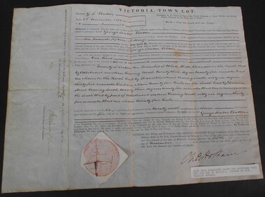
Document - WES HARRY COLLECTION: SALE OF LAND ALLOTMENT 20 IN TOWNSHIP OF WHITE HILLS DATED 5TH NOVEMBER 1855, 1855
Land Sale Agreement dtaed 5th November 1855 signed and selaed by Charles Hotham Allotment 20 Section 10 Township of White Hills Sold to George Souter Butter for the sum of six pounds and fifteen shillings