Showing 849 items
matching valley buildings
-
 Eltham District Historical Society Inc
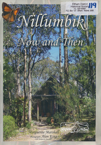
Book, Marguerite Marshall, Nillumbik now and then / Marguerite Marshall; photographs Alan King with Marguerite Marshall, 2008
Nillumbik Now and Then takes the reader on a journey from when the Aboriginal people were this area's sole inhabitnats, to the present day. Nillumbik's history - told in this collection of 96 stories, which are nearly all based on sites - mirrors those of the wider Australian community. It includes tales of the Wurundjeri people, a former convict, farmers, a bushranger, gold-mining, soldiers, artists, intellectuals, environmentalists and sportspeople. Each story is illustrated with a photograph. As a journalist with the former Diamond Valley News, Marguerite Marshall wrote a series of articles on local places of historic interest, later published as the small book "Eltham Shire - Historic Buildings and Places". Many years later an expanded version was published under the title "Nillumbik Now and Then". This is a much larger version of "Nillumbik Now and Then", including significant rewriting and many additional articles. The new publication was made possible by financial support from the Victorian Public Records Office, Bendigo Bank and Nillumbik Shire Council. EDHS and other historical societies in Nillumbik assisted with content for many of the stories. The book was launched at the Eltham Library on Wednesday 19th November 2008. Source: EDHS Newsletter No 183, November 2009 The front cover art depicts The former house of naturalist and artist Neil Douglas at Bend of Islands, photographer Marguerite Marshall. This collection of almost 130 photos and stories about places and people within the Shire of Nillumbik, an urban and rural municipality in Melbourne's north, contributes to an understanding of the history of the Shire. Published in 2008 immediately prior to the Black Saturday bushfires of February 7 2009, it documents sites that were impacted, and in some cases destroyed by the fires. It includes photographs taken especially for the publication, creating a unique time capsule representing the Shire in the early 21st century. It remains the most recent comprehenesive publication devoted to the Shire's history connecting local residents to the past. Paperback; x, 198 p. : ill., ports. ; 30 cm.Signed by the authornillumbik shire, houses, buildings, weller's hotel, landmarks, bend of islands -
 Eltham District Historical Society Inc
Photograph, Peter Bassett-Smith, Construction of Eltham Community Centre, June 1977, 1977
... melbourne eltham eltham community centre buildings construction ...The valley of Diamond Creek from Bridge Street looking south to Eltham Community Centreeltham, eltham community centre, buildings, construction -
 Warrnambool and District Historical Society Inc.
Document - Lyndoch Warrnambool 1979 Annual Report, 1979
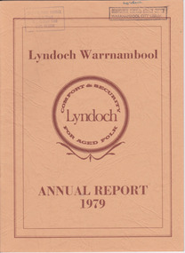
This is the 1979 Annual Report for Lyndoch Home and Hospital for the Aged, Warrnambool. It contains lists of Board Members, a President’s Report, a sketch of a proposed new building, financial reports, photographs and a list of Life Governors. Lyndoch Home for the Aged was established in 1952 and has developed with a wide range of facilities for the aged since that date. The original Lyndoch property near the mouth of the river Hopkins was owned by a Melbourne tea merchant, George Rolfe, who bought the land when there were only on the site a couple of cottages and a larger building which had been a school, Warrnambool Grammar, run by Henry Kemmis. Rolfe acquired the land in the 1870s and named the property Lyndoch after the town in the Barossa Valley where he had lived. He owned Lyndoch for 44 years and it was his stepdaughter, Florence Lake who built in the 1920s the bungalow known as Lyndoch which forms the original building of the Lyndoch Home for the Aged. Today the facility is called Lyndoch Living.This report is kept for the benefit of researchers wanting details of the history of Lyndoch over the past thirty or forty years.This is a booklet with a cardboard buff-coloured cover. There are six double-sided pages with printed material on white paper with a yellow and orange stripe across the top of the pages.On front cover: Lyndoch Warrnambool, Annual Report 1979 In brown circle on front cover: Lyndoch, Comfort and Security for Aged Folk Two library stamps on front cover (Warrnambool Library) lyndoch, aged care facility, warrnambool, hopkins, warrnambool grammar -
 Warrnambool and District Historical Society Inc.
Document - Lyndoch Warrnambool 1982 Annual Report
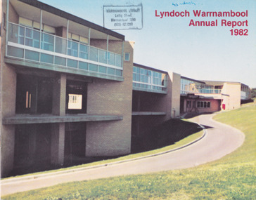
This is the 1982 Annual Report for Lyndoch Home and Hospital for the Aged, Warrnambool. It contains lists of Board Members, a President’s Report, Lyndoch’s Aims, financial reports, photographs and a list of Life Governors. Lyndoch Home for the Aged was established in 1952 and has developed with a wide range of facilities for the aged since that date. The original Lyndoch property near the mouth of the Hopkins River was owned by a Melbourne tea merchant, George Rolfe, who bought the land when there were on the site only a couple of cottages and a larger building which had been a school, Warrnambool Grammar, run by Henry Kemmis. Rolfe acquired the land in the 1870s and named the property Lyndoch after the town in the Barossa Valley where he had lived. He owned Lyndoch for 44 years and it was his stepdaughter, Florence Lake who built in the 1920s the bungalow known as Lyndoch which forms the original building of the Lyndoch Home for the Aged, Today the facility is called Lyndoch Living. This 1982 report is kept for the benefit of researchers wanting details of the history of Lyndoch over the past 30 or 40 years. This is a booklet with a plasticized cover with a white back and a multi-coloured front cover. The front cover has a photograph of a Lyndoch building. There are six double-sided pages with printed material and photographs on white paper and a yellow and orange strip across the top of the pages. The pages are stapled.On front cover: Lyndoch Warrnambool Annual Report 1982 Stamp of Warrnambool Library On back cover: A red circle with the words ‘Lyndoch, Comfort and Security for Aged Folk’ lyndoch aged care facility, warrnambool, lyndoch warrnambool -
 Warrnambool and District Historical Society Inc.
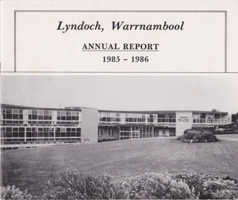
Document - Lyndoch Warrnambool Annual Report 1985-86, 1986
This is the 1985-6 Annual Report for Lyndoch Home and Hospital for the Aged, Warrnambool. It contains lists of Board Members, a President’s Report, photographs, Lyndoch’s Aims, financial reports and a list of Life Governors. Lyndoch Home for the Aged was established in 1952 and has developed with a wide range of facilities for the aged since that date. The original Lyndoch property near the mouth of the River Hopkins was owned by a Melbourne tea merchant, George Rolfe, who bought the land when there were on the site only a couple of cottages and a larger building which had been a school, Warrnambool Grammar, run by Henry Kemmis. Rolfe acquired the land in the 1870s and named the property Lyndoch after the town in the Barossa Valley where he had lived. He owned Lyndoch for 44 years ad it was his stepdaughter Florence Lake who built in the 1920s the bungalow known as Lyndoch which forms the original building of Lyndoch Home for the Aged. Today the facility is called Lyndoch Living. This 1985-6 report is kept for the benefit of researchers wanting details of the history of Lyndoch over the past 30 or 40 years.This is a booklet with a plasticized white cover with a black and white photograph of a Lyndoch building on the front cover. There are eight double-sided pages with printed material and photographs. The pages are stapled.On front cover: ‘Lyndoch, Warrnambool, Annual Report, 1985-1986 On back cover: A black circle with the words: ‘Lyndoch, Comfort and Security for Aged Folk’. lyndoch aged care facility, warrnambool -
 Emerald Museum & Nobelius Heritage Park
Photograph, Nightingale/Thompson Collection, 20/11/1906
Alice May (known as May) Nightingale married Frederick Sparks. They were living in Cranbourne (Lyndhurst) in 1906Thompson CollectionB/W photograph of 4 people outside brick building Cranbourne/Lyndhurst area'To Dear Mother, with love from May Nov 20th 1906may sparks nee nightingale, frederick sparks -
 Emerald Museum & Nobelius Heritage Park
Photograph, Mina Moore, Nightingale/Thompson Collection, 1907
child as yet to be identifiedThompson Collection Mina Moore photographerStudio photograph mounted on cream card of female child (3 years) Front: Mina Moore (photographer, hand written). Inscription: Peggy at 3 years old. With love to her Godfather. May 1907 Back: Mina Moore Auditorium Building, Collins Street Melbourne Australia. Hand written in pencil: Green Be?lthompson collection, nightingale, mina moore -
 Emerald Museum & Nobelius Heritage Park
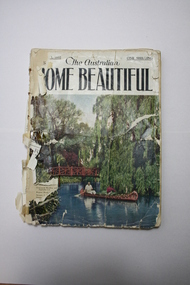
Magazine, The Australian Home Beautiful, June 1932
The Australian Home Beautiful was a popular Magazine years ago .In the May edition there is a local article on a building of importance in Sycamore Ave. EmeraldCollection of Monthly Journals . Vol,10, No.1 January 1. 1932 to June 1932 priced at One Shilling. photo of bridge with canoe under it.January 1st 1932 with advertising and Storieshome beautiful. historical stories. photographs -
 Emerald Museum & Nobelius Heritage Park
Photograph, Nightingale/Thompson Collection, circa 1890 - 1920
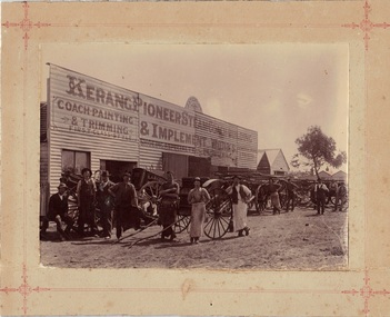
B/W photo on cream embossed card, held in modern folder with inscription. Original card has been cut down. Business name in photo is 'J Steward - Kerang Pioneer Steam Coach Building and Implement Work Engineering (General work and repairs neatly executed) Business name on cart: EA Barrett - BakerEarly photograph of commercial buildings in KerangB/W photograph of men standing outside coach building/works at Kerang Victoria on cream cardon re-cut mount card 'Kerang 1920'snightingale, thompson, kerang -
 Emerald Museum & Nobelius Heritage Park
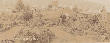
Photograph, Early postcard, Emerald Victoria, 1909
Formally Main Road, Emerald; now called Emerald Gembrook Road. Depicts 7 buildings, 6 identified as follows from right to left: Abbatoir, Cooper's Butcher, Andrew's General Store, Madigan's Bakery, Archilbald & Moffatt Grocery and Bakery, Walter's Barber Store1909 photograph of the commercial district in Emerald, Faded sepia postcard depicting Emerald Main Street, Commercial District (1909)Front: Emerald Victoria Handwritten on Back: Dec. 1909 (pencil); 'Wishing you the compliments of the season, hoping you will drive over some day and see how we are getting on. From RJ....? Emerald. To: Rev'd Whiteside, Beaconsfield Railway Station. Vicemerald, commercial district -
 Emerald Museum & Nobelius Heritage Park
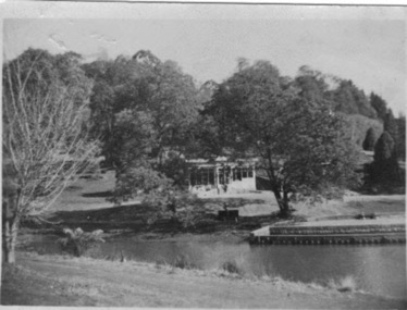
B/W Photograph, Emerald Park Lake c. 1960, 1960
The Stone family were migrants from Wales, living at the Fisherman's Bend Migrant Hotel around 1960. This photograph was taken on a day trip to Emerald Park Lake.The photograph shows the state of Emerald Park Lake around 1960.B/W photograph, looking across a stretch of Emerald Lake towards a building in the background, probably the kiosk.REAR: stamp "Ilford 260"emerald park lake -
 Eltham District Historical Society Inc
Negative - Photograph, The Bridge, Hurstbridge, Vic, c.1925
Copied from brochure "Wattle Valley Estate" 7 minutes from the bridge. The new bridge designed by Sir John Monash over the Diamond Creek near Hurst's home of 'Mia Mia' at Hurstbridge. The Wattle Valley Estate was first advertised in August 1925 as weekend building allotments by the Greater Melbourne Land and Development Company. Advertised from £28.10.0 or £60 per block. In August 1926, 30 picked allotments of 60x150 feet were put up for auction Saturday August 14, 1926 with frontages to Valley View Road and Fawkner Crescent advertised in the “Heart of the Glorious Wattle Country” and “Within 15 Minutes of the Newly Electrified Railway Station”. The Advertiser on August 13, 1926 in an article promoting the auction stated “the estate is regarded as one of the best in the district, and will be sold practically without reserve.” It is noted that an advertisement running in The Argus February 22, 1951 offered the remaining 16 blocks for sale at £12.10.0 or £200 the lot. By March 7, the remaining blocks were advertised at £17.10.0 The Wattle Valley Estate took over 20 years to sell and then people could not build on them This image was also used in a brochure advertising the "Wattle Valley Estate", which forms part of the Shire of Eltham Pioneers Photograph Collection (Cross Reference Photo No.(s): 1056, 1057)This photo forms part of a collection of photographs gathered by the Shire of Eltham for their centenary project book,"Pioneers and Painters: 100 years of the Shire of Eltham" by Alan Marshall (1971). The collection of over 500 images is held in partnership between Eltham District Historical Society and Yarra Plenty Regional Library (Eltham Library) and is now formally known as the 'The Shire of Eltham Pioneers Photograph Collection.' It is significant in being the first community sourced collection representing the places and people of the Shire's first one hundred years.Digital image 4 x 5 inch B&W Negshire of eltham pioneers photograph collection, hurstbridge, bridge, diamond creek (creek), monash bridge, wattle valley estate -
 Eltham District Historical Society Inc
Negative - Photograph, Rose Stereograph Company, The Bridge, Hurstbridge, Vic, c.1925
Copied from brochure "Wattle Valley Estate". The new bridge designed by Sir John Monash over the Diamond Creek near Hurst's original home "Mia Mia" seen in the distance. Reprinted from brochure advertising "Wattle Valley Estate" 7 minutes from bridge. The Wattle Valley Estate was first advertised in August 1925 as weekend building allotments by the Greater Melbourne Land and Development Company. Advertised from £28.10.0 or £60 per block. In August 1926, 30 picked allotments of 60x150 feet were put up for auction Saturday August 14, 1926 with frontages to Valley View Road and Fawkner Crescent advertised in the “Heart of the Glorious Wattle Country” and “Within 15 Minutes of the Newly Electrified Railway Station”. The Advertiser on August 13, 1926 in an article promoting the auction stated “the estate is regarded as one of the best in the district, and will be sold practically without reserve.” It is noted that an advertisement running in The Argus February 22, 1951 offered the remaining 16 blocks for sale at £12.10.0 or £200 the lot. By March 7, the remaining blocks were advertised at £17.10.0 The Wattle Valley Estate took over 20 years to sell and then people could not build on them This image was also used in a brochure advertising the "Wattle Valley Estate", which forms part of the Shire of Eltham Pioneers Photograph Collection (Cross Reference Photo No.(s): 1056, 1057). Also cross reference SEPP_1028 / 29 for other views of Mia Mia. Part of a slide show presentation "Bridges & Waterways of the Shire" by Russell Yeoman to the 13 September 1989 Society meeting. The presentation included slides of historic photos from the Shire of Eltham Pioneers collections as well as several recent views. This photo forms part of a collection of photographs gathered by the Shire of Eltham for their centenary project book,"Pioneers and Painters: 100 years of the Shire of Eltham" by Alan Marshall (1971). The collection of over 500 images is held in partnership between Eltham District Historical Society and Yarra Plenty Regional Library (Eltham Library) and is now formally known as the 'The Shire of Eltham Pioneers Photograph Collection.' It is significant in being the first community sourced collection representing the places and people of the Shire's first one hundred years.Digital image 4 x 5 inch B&W Negshire of eltham pioneers photograph collection, hurstbridge, mia mia, bridge, diamond creek (creek), monash bridge, wattle valley estate -
 Eltham District Historical Society Inc
Negative - Photograph, Popular Picnicing at Hurstbridge, c.1925
Picnickers enjoying a Sunday outing near the Wattle Valley Estate at Hurstbridge. Copied from brochure "Wattle Valley Estate". It is believed the picture is taken at the northwest corner of the intersection of Wattletree Road and Hurstbridge-Arthurs Creek Road looking southeast towards the township (most likely where the house is located on the property of what is today No. 2 Wattletree Road)- https://goo.gl/maps/VDorwCe1rJJUapjE6 According to a comment by Jean Verso (via @nillumbikcouncil FB page 3 Jan 2020) - "This view is from Wattle Tree Road with Haleys Gully Road to the right and across the creek to William Gray's nursery at Allwood. The building to the far left looks like Dorset House. The building on the left in the middle distance is still there today and has been used for storage and as a stable/tack room for a number of years." The Wattle Valley Estate was first advertised in August 1925 as weekend building allotments by the Greater Melbourne Land and Development Company. Advertised from £28.10.0 or £60 per block. In August 1926, 30 picked allotments of 60x150 feet were put up for auction Saturday August 14, 1926 with frontages to Valley View Road and Fawkner Crescent advertised in the “Heart of the Glorious Wattle Country” and “Within 15 Minutes of the Newly Electrified Railway Station”. The Advertiser on August 13, 1926 in an article promoting the auction stated “the estate is regarded as one of the best in the district, and will be sold practically without reserve.” It is noted that an advertisement running in The Argus February 22, 1951 offered the remaining 16 blocks for sale at £12.10.0 or £200 the lot. By March 7, the remaining blocks were advertised at £17.10.0 The Wattle Valley Estate took over 20 years to sell and then people could not build on them Cross Ref EDHS_02665 Rose Series Postcard P. 4341, "View at Hurstbridge, Vic." Also, other images from sales brochure SEPP_1055 / 1056This photo forms part of a collection of photographs gathered by the Shire of Eltham for their centenary project book,"Pioneers and Painters: 100 years of the Shire of Eltham" by Alan Marshall (1971). The collection of over 500 images is held in partnership between Eltham District Historical Society and Yarra Plenty Regional Library (Eltham Library) and is now formally known as the 'The Shire of Eltham Pioneers Photograph Collection.' It is significant in being the first community sourced collection representing the places and people of the Shire's first one hundred years.Digital image 4 x 5 inch B&W Neg1925, dorset house, fawkner crescent, haleys gully road, hurstbridge, hurstbridge-arthurs creek road, picnic, postcards, shire of eltham pioneers photograph collection, valley view road, wattle valley estate, wattletree road, exhibition yprl 2019-12 -
 Eltham District Historical Society Inc
Photograph, Opening of Ellis Cottage, 14 March 1994, 14/03/1994
A rubble-stone hipped roof cottage known as Ellis Cottage, was built by small-time farmer William Ellis from local uncut stone 1865-66. It was restored by the Shire of Diamond Valley. Cr. David Hay opened the restored building for the use of the Nillumbik Historical Society on March 14, 1994 Two colour photographsellis cottage, opening ceremony, nillumbik historical society, david hay -
 Eltham District Historical Society Inc
Photograph - Postcard, Rose Stereograph Company, View at Hurstbridge, Vic, c.1925
Rose Series Postcard P. 4341 “View at Hurstbridge, Vic.” Picnickers enjoying a Sunday outing near the Wattle Valley Estate at Hurstbridge. Copied from brochure "Wattle Valley Estate". It is believed the picture is taken at the northwest corner of the intersection of Wattletree Road and Hurstbridge-Arthurs Creek Road looking southeast towards the township (most likely where the house is located on the property of what is today No. 2 Wattletree Road)- https://goo.gl/maps/VDorwCe1rJJUapjE6 According to a comment by Jean Verso (via @nillumbikcouncil FB page 3 Jan 2020) - "This view is from Wattle Tree Road with Haleys Gully Road to the right and across the creek to William Gray's nursery at Allwood. The building to the far left looks like Dorset House. The building on the left in the middle distance is still there today and has been used for storage and as a stable/tack room for a number of years." The Wattle Valley Estate was first advertised in August 1925 as weekend building allotments by the Greater Melbourne Land and Development Company. Advertised from £28.10.0 or £60 per block. In August 1926, 30 picked allotments of 60x150 feet were put up for auction Saturday August 14, 1926 with frontages to Valley View Road and Fawkner Crescent advertised in the “Heart of the Glorious Wattle Country” and “Within 15 Minutes of the Newly Electrified Railway Station”. The Advertiser on August 13, 1926 in an article promoting the auction stated “the estate is regarded as one of the best in the district, and will be sold practically without reserve.” It is noted that an advertisement running in The Argus February 22, 1951 offered the remaining 16 blocks for sale at £12.10.0 or £200 the lot. By March 7, the remaining blocks were advertised at £17.10.0 The Wattle Valley Estate took over 20 years to sell and then people could not build on them Cross Ref SEPP_1057, “Popular Picnicing at Hurstbridge” rcopied from Wattle Valley estate sales brochure.Digital file only Postcards scanned from the collection of Michael Aitken on loan to EDHS, 13 Feb 20181925, dorset house, exhibition yprl 2019-12, fawkner crescent, haleys gully road, hurstbridge, hurstbridge-arthurs creek road, michael aitken collection, picnic, postcards, rose stereograph company, shire of eltham pioneers photograph collection, valley view road, wattle valley estate, wattletree road -
 Eltham District Historical Society Inc
Photograph - Postcard, The Bridge, Hurstbridge, Vic
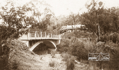
Arched Bridge (Monash Bridge) The Rose Series P. 4036 Reproduced in a brochure advertising the "Wattle Valley Estate" 7 minutes from the bridge. The new bridge designed by Sir John Monash over the Diamond Creek near Hurst's original home "Mia Mia" seen in the distance. The Wattle Valley Estate was first advertised in August 1925 as weekend building allotments by the Greater Melbourne Land and Development Company. Advertised from £28.10.0 or £60 per block. In August 1926, 30 picked allotments of 60x150 feet were put up for auction Saturday August 14, 1926 with frontages to Valley View Road and Fawkner Crescent advertised in the “Heart of the Glorious Wattle Country” and “Within 15 Minutes of the Newly Electrified Railway Station”. The Advertiser on August 13, 1926 in an article promoting the auction stated “the estate is regarded as one of the best in the district, and will be sold practically without reserve.” It is noted that an advertisement running in The Argus February 22, 1951 offered the remaining 16 blocks for sale at £12.10.0 or £200 the lot. By March 7, the remaining blocks were advertised at £17.10.0 The Wattle Valley Estate took over 20 years to sell and then people could not build on them.Digital file only Postcards scanned from the collection of Michael Aitken on loan to EDHS, 13 Feb 2018michael aitken collection, postcards, hurstbridge, monash bridge, bridge, diamond creek (creek), mia mia, shire of eltham pioneers photograph collection, wattle valley estate -
 Ringwood and District Historical Society
Envelope, Packet: Yarra Valley Church of England School - Founding 1965, Papers, Opening, Land Sales etc
Yarra Valley Church of England School; Founding 1965; Building Appeal 1964, 1968; Service for unveiling and dedication of plaque; Service for opening of school; Notes on land sales -
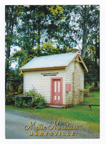
 Marysville & District Historical Society
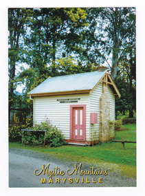
Postcard (item) - Colour postcard, Nucolorvue Productions Pty. Ltd, Mystic Mountains-MARYSVILLE, Pre 2009
A colour photograph taken of the original Police Station in Marysville in Victoria.A colour photograph taken of the original Police Station in Marysville in Victoria. The Police Station was officially opened on the 30th June, 1865. The building then went on to house the Marysville Historical Society's collection from its inception in 1969. The building and all its contents were destroyed in the 2009 Black Saturday bushfires. This postcard was produced by Nucolorvue Productions as a souvenir of Marysville.The original Police Station at Marysville/ officially opened 30th June 1865./ It is now re-situated at Burrungeen Park. NU-COLOR-VUE/ AUSTRALIA'S NATIONAL POSTCARD COMPANY STANDARD POSTAGE POSTCODE 17MA010 NCV 11128 Nucolorvue Productions Tel. 1 800 806 053 Made in Australia cmarysville, police station, victoria, nucolorvue productions, postcard, souvenir, marysville & district historical society, 2009 black saturday bushfires -
 Marysville & District Historical Society
Postcard (item) - Colour postcard, Nucolorvue Productions Pty. Ltd, Mystic Mountains-MARYSVILLE, Pre 2009
A colour photograph taken of the original Police Station in Marysville in Victoria.A colour photograph taken of the original Police Station in Marysville in Victoria. The Police Station was officially opened on the 30th June, 1865. The building then went on to house the Marysville Historical Society's collection from its inception in 1969. The building and all its contents were destroyed in the 2009 Black Saturday bushfires. This postcard was produced by Nucolorvue Productions as a souvenir of Marysville.The original Police Station at Marysville/ officially opened 30th June 1865./ It is now re-situated at Burrungeen Park. NU-COLOR-VUE/ AUSTRALIA'S NATIONAL POSTCARD COMPANY STANDARD POSTAGE POSTCODE 17MA010 NCV 11128 Nucolorvue Productions Tel. 1 800 806 053 Made in Australia cmarysville, police station, victoria, nucolorvue productions, postcard, souvenir, marysville & district historical society, 2009 black saturday bushfires -
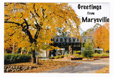 Marysville & District Historical Society
Postcard (item) - Colour postcard, Marysville Post Office, Greetings from Marysville, Post 2009
A colour photograph taken of the Marysville Visitor Information Centre during Autumn.A colour photograph taken of the Marysville Visitor Information Centre during Autumn. This building was initially built as a temporary structure to house the Building Advisory Centre after the 2009 Black Saturday bushfires. This postcard was produced by the Marysville Post Office as souvenir of Marysville.The Golden Glow of Autumn Marysville Post Office AFFIX/ STAMP/ HERE Postcard by Sandy Berthelsenmarysville, victoria, autumn, postcard, souvenir, marysville post office, 2009 black saturday bushfires -
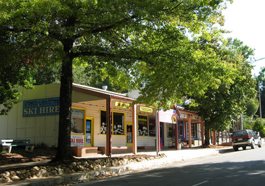 Marysville & District Historical Society
Photograph (Item) - Colour photograph, Unknown
A digital copy of a colour photograph of Cross Country Ski Hire in Marysville in Victoria.A digital copy of a colour photograph of Cross Country Ski Hire in Marysville in Victoria. This building, along with most of the town of Marysville, was destroyed in the 2009 Black Saturday bushfires.marysville, victoria, cross country ski hire, ski hire, lake mountain, 2009 black saturday bushfires -
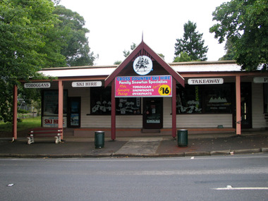 Marysville & District Historical Society
Photograph (Item) - Colour photograph, Unknown
A digital copy of a colour photograph of Cross Country Ski Hire in Marysville in Victoria.A digital copy of a colour photograph of Cross Country Ski Hire in Marysville in Victoria. This building, along with most of the town of Marysville, was destroyed in the 2009 Black Saturday bushfires.marysville, victoria, cross counry ski hire, lake mountain, 2009 black saturday bushfires -
 Marysville & District Historical Society
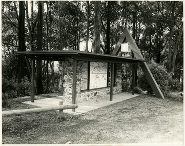
Photograph (Item) - Black and white photographs, Unknown
Two black and white photographs of the tourist information board which is at the entrance to Marysville. The Marysville Tourist and Progress Association were responsible for the building of this structure. It contains maps and information for attractions in and around the local area as well as information pertaining to local clubs and organisations.Two black and white photographs of the tourist information board which is at the entrance to Marysville. The Marysville Tourist and Progress Association were responsible for the building of this structure. It contains maps and information for attractions in and around the local area as well as information pertaining to local clubs and organisations.marysville, victoria, marysville tourist and progress association, tourism information, tourism -
 Marysville & District Historical Society
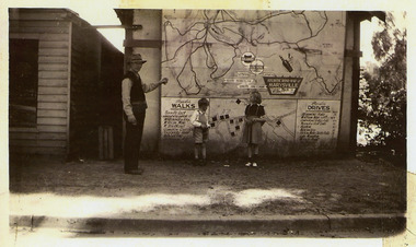
Photograph (Item) - Black and white photograph, 1949
A copy of a black and white photograph of an Atlantic Road Map of Marysville adhered to an unknown building in Marysville.A copy of a black and white photograph of an Atlantic Road Map of Marysville adhered to an unknown building in Marysville.marysville, victoria, maps, atlantic road map -
 Marysville & District Historical Society
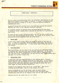
Flyer (Item) - Information Flyer, Forests Commission, Victoria, FOREST WALKS - MARYSVILLE, 1918-1983
An information flyer that was produced as a guide to the forest walks in and near Marysville by the Forests Commission of Victoria. The Forests Commission Victoria (FCV) was the main government authority responsible for management and protection of State forests in Victoria, Australia between 1918 and 1983. The Commission was responsible for ″forest policy, prevention and suppression of bushfires, issuing leases and licences, planting and thinning of forests, the development of plantations, reforestation, nurseries, forestry education, the development of commercial timber harvesting and marketing of produce, building and maintaining forest roads, provision of recreation facilities, protection of water, soils and wildlife, forest research and making recommendations on the acquisition or alienation of land for forest purposes″. An extensive network of walking tracks surrounds Marysville and they offer a variety of walks ranging in various levels of difficulty. This information flyer provides information such as the level of difficulty for six suggested walks around Marysville.An information flyer that was produced as a guide to the forest walks in and near Marysville by the Forests Commission of Victoria.marysville, victoria, australia, forest walks, forests commission victoria, beauty spot walk, tree fern gully walk, michaeldene track, keppel track, woods lookout track -
 Marysville & District Historical Society
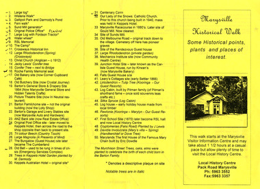
Ephemera (Item) - Information brochure, Marysville & District Historical Society Inc, Marysville Historical Walk, 2003
An information brochure outlining a historical walk around Marysville that takes in some of the more historical sites in the township. This brochure was created by the Marysville & District Historical Society Inc in 2003. Most of the buildings, along with most of the town, were destroyed in the 2009 Black Saturday bushfires.An information brochure outlining a historical walk around Marysville that takes in some of the more historical sites in the township.marysville, victoria, australia, information brochure, 2009 black saturday bushfires -
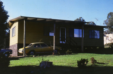 Marysville & District Historical Society
Photograph (Item) - Colour photograph, Unknown
A colour photograph of one of the cottages at Amber View Cottages in Marysville. These cottages, along with most of the buildings in the township, were destroyed in the 2009 Black Saturday bushfires.A colour photograph of one of the cottages at Amber View Cottages in Marysville.amber view cottages, marysville, victoria, australia, accommodation, photograph, 2009 black saturday bushfires -
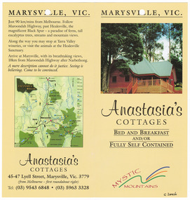 Marysville & District Historical Society
Ephemera (Item) - Information brochure, Anastasia's COTTAGES, Unknown
An information brochure regarding Anastasia's Cottages in Marysville. These cottages, along with most of the buildings in the township, were destroyed in the 2009 Black Saturday bushfires.An information brochure regarding Anastasia's Cottages in Marysville.marysville, victoria, australia, anastasia's cottages, information brochure, accommodation, 2009 black saturday bushfires -
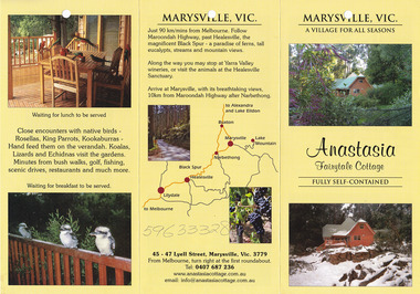 Marysville & District Historical Society
Ephemera (Item) - Information brochure, Anastasia Fairytale Cottage, Unknown
An information brochure regarding Anastasia Fairytale Cottage in Marysville. This cottage, along with most of the buildings in the township, was destroyed in the 2009 Black Saturday bushfires.An information brochure regarding Anastasia Fairytale Cottage in Marysville.marysville, victoria, australia, information brochure, accommodation, anastasia fairytale cottage, 2009 black saturday bushfires