Showing 14941 items
matching view-finder
-
 Eltham District Historical Society Inc
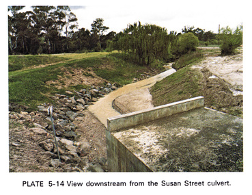
Work on paper (Sub-Item) - Photograph, View downstream from the Susan Street culvert
Colour photograph of the view downstream from the Susan Street culvert, Elthameltham, susan street, culvert, drain, channel -
 Eltham District Historical Society Inc
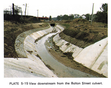
Work on paper (Sub-Item) - Photograph, View downstream from the Bolton Street culvert
Colour photograph of the view downstream from the Bolton Street culvert, Elthameltham, channel, concrete, drain, bolton street -
![Photograph - Digital Image, Greensborough Cemetery [view 3] 2013, 18/06/2013](/media/collectors/4f729f5697f83e03086015b8/items/54c5f91f2162f1173055ddc2/item-media/54c5f9512162f1173055dfc8/item-fit-380x285.jpg) Greensborough Historical Society
Greensborough Historical SocietyPhotograph - Digital Image, Greensborough Cemetery [view 3] 2013, 18/06/2013
View of Greensborough Cemetery, June 18th 2013. Photography by Marilyn Smith.Greensborough Cemetery was created when land was given for the cemetery by Mr William Poulter, a local settler, about 1864. The cemetery holds the graves of many early settlers in the district. Digital copy of colour photograph of Greensborough Cemeterygreensborough cemetery -
![Photograph - Digital Image, Greensborough Cemetery [view 2] 2014, 28/05/2014](/media/collectors/4f729f5697f83e03086015b8/items/54c5f9d52162f1173055e7b3/item-media/54c5fa9f2162f1173055f50b/item-fit-380x285.jpg) Greensborough Historical Society
Greensborough Historical SocietyPhotograph - Digital Image, Greensborough Cemetery [view 2] 2014, 28/05/2014
View of Greensborough Cemetery, 28th May 2014. Photography by Marilyn Smith.Greensborough Cemetery was created when land was given for the cemetery by Mr William Poulter, a local settler, about 1864. The cemetery holds the graves of many early settlers in the district. Digital copy of colour photograph of Greensborough Cemeterygreensborough cemetery -
![Photograph - Digital Image, Greensborough Cemetery [view 3] 2014, 28/05/2014](/media/collectors/4f729f5697f83e03086015b8/items/54c5fab02162f1173055f6ef/item-media/54c5fadf2162f1173055faf6/item-fit-380x285.jpg) Greensborough Historical Society
Greensborough Historical SocietyPhotograph - Digital Image, Greensborough Cemetery [view 3] 2014, 28/05/2014
View of Greensborough Cemetery, 28th May 2014. Photography by Marilyn Smith.Greensborough Cemetery was created when land was given for the cemetery by Mr William Poulter, a local settler, about 1864. The cemetery holds the graves of many early settlers in the district. Digital copy of colour photograph of Greensborough Cemeterygreensborough cemetery -
![Photograph - Digital Image, Greensborough Cemetery [view 4] 2014, 28/05/2014](/media/collectors/4f729f5697f83e03086015b8/items/54c5fb402162f1173055ff6a/item-media/54c5fb702162f117305602cc/item-fit-380x285.jpg) Greensborough Historical Society
Greensborough Historical SocietyPhotograph - Digital Image, Greensborough Cemetery [view 4] 2014, 28/05/2014
View of Greensborough Cemetery, 28th May 2014. Photography by Marilyn Smith.Greensborough Cemetery was created when land was given for the cemetery by Mr William Poulter, a local settler, about 1864. The cemetery holds the graves of many early settlers in the district. Digital copy of colour photograph of grave/headstone.greensborough cemetery -
![Photograph - Digital Image, Greensborough Cemetery [view 5] 2014, 28/05/2014](/media/collectors/4f729f5697f83e03086015b8/items/54c5fbcf2162f11730560d50/item-media/54c5fc022162f11730560fbb/item-fit-380x285.jpg) Greensborough Historical Society
Greensborough Historical SocietyPhotograph - Digital Image, Greensborough Cemetery [view 5] 2014, 28/05/2014
View of Greensborough Cemetery, 28th May 2014. Photography by Marilyn Smith.Greensborough Cemetery was created when land was given for the cemetery by Mr William Poulter, a local settler, about 1864. The cemetery holds the graves of many early settlers in the district. Digital copy of colour photograph of Greensborough Cemeterygreensborough cemetery -
![Photograph - Digital image, Greensborough Cemetery [view 1], 18/06/2013](/media/collectors/4f729f5697f83e03086015b8/items/54c5f72c2162f1173055bbb2/item-media/54c5f7722162f1173055c101/item-fit-380x285.jpg) Greensborough Historical Society
Greensborough Historical SocietyPhotograph - Digital image, Greensborough Cemetery [view 1], 18/06/2013
View of Greensborough Cemetery, June 18th 2013. Photography by Marilyn Smith.Greensborough Cemetery was created when land was given for the cemetery by Mr William Poulter, a local settler, about 1864. The cemetery holds the graves of many early settlers in the district. Digital copy of colour photograph of Greensborough Cemeterygreensborough cemetery -
![Photograph - Digital Image, Greensborough Cemetery [view 2] 2013, 18/06/2013](/media/collectors/4f729f5697f83e03086015b8/items/54c5f8802162f1173055d3d6/item-media/54c5f8ba2162f1173055d66a/item-fit-380x285.jpg) Greensborough Historical Society
Greensborough Historical SocietyPhotograph - Digital Image, Greensborough Cemetery [view 2] 2013, 18/06/2013
View of Greensborough Cemetery, June 18th 2013. Photography by Marilyn Smith.Greensborough Cemetery was created when land was given for the cemetery by Mr William Poulter, a local settler, about 1864. The cemetery holds the graves of many early settlers in the district. Digital copy of colour photograph of Greensborough Cemeterygreensborough cemetery -
![Photograph - Digital Image, Greensborough Cemetery [view 1] 2014, 28/05/2014](/media/collectors/4f729f5697f83e03086015b8/items/581060aed0cdd12660a1c09d/item-media/581060f6d0cdd12660a1ece7/item-fit-380x285.jpg) Greensborough Historical Society
Greensborough Historical SocietyPhotograph - Digital Image, Greensborough Cemetery [view 1] 2014, 28/05/2014
View of Greensborough Cemetery, 28th May 2014. Photography by Marilyn Smith.Greensborough Cemetery was created when land was given for the cemetery by Mr William Poulter, a local settler, about 1864. The cemetery holds the graves of many early settlers in the district. Digital copy of colour photograph of Greensborough Cemetery -
 Greensborough Historical Society
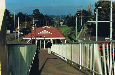
Photograph - Digital image, Frank Solomon, Greensborough Station: view down ramp, 1990c
Greensborough Station: view down ramp from pedestrian overpass to station.Digital copy of colour photographgreensborough station -
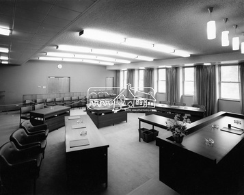
 Eltham District Historical Society Inc
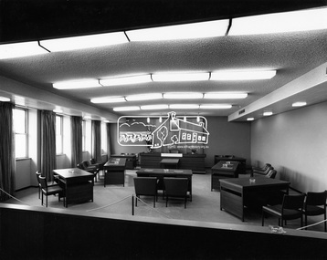
Photograph, Hugh Fisher, Eltham - View of Council Chamber, c.1965, 1965
View of Council Chamber in brand new Eltham Shire Offices 1965This photo forms part of a collection of photographs gathered by the Shire of Eltham for their centenary project book, "Pioneers and Painters: 100 years of the Shire of Eltham" by Alan Marshall (1971). The collection of over 500 images is held in partnership between Eltham District Historical Society and Yarra Plenty Regional Library (Eltham Library) and is now formally known as 'The Shire of Eltham Pioneers Photograph Collection.' It is significant in being the first community sourced collection representing the places and people of the Shire's first one hundred years.Digital imagesepp, shire of eltham pioneers photograph collection, eltham, eltham shire office, council chamber -
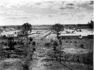 Tatura Irrigation & Wartime Camps Museum
Photograph, View of Camp 3
View of Camp 3 taken from Southern tower, c.1946. -
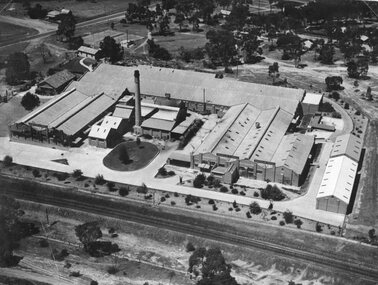 Stawell Historical Society Inc
Photograph, North Western Woollen Mills with the Rail line in foreground -- Aerial View
North Western Woollen Mills Aerial View. Rail line in foregroundstawell industry -
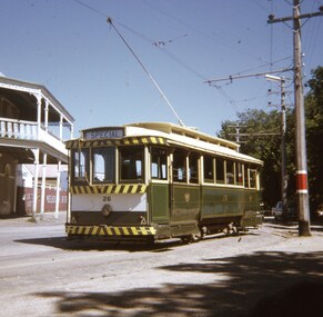 Ballarat Tramway Museum
Slide - 27 mm sq slide/s - set of 5, Andrew Howlett, Tram 26 on private tour - View Point line, Mar. 1969
Yields information about a special tram service during March 1969 and some unusual moves.Set of four Colour slides, Kodak white cardboard mount, developed March 1969 of a special tram that apparently ran from the depot via View Point, shunted at Ripon St and again at Hospital corner. ..1 - No. 26 running a special in Wendouree Parade, View Point, with the Lake View Hotel. .2 - ditto - and a catering company in the view, as well as a Telephone box. .3 - running from Ripon St into Sturt St. .4 - shunting at Hospital corner - then possibly crossed 34 at Parker St Loop - see 7668. .5 - ditto, but before .4, with the tram rounding the corner from the North side of Sturt St into Drummond St. It would then appear that the tram then reversed a bit before going back into Sturt St onto the South side. One of a series of tour photos - see Reg item 7667, 7668, 7683 and 7701.ballarat, tramways, trams, view point, wendouree parade, ripon st, hospital corner, sturt st, tours, tram 26 -
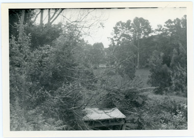 Mt Dandenong & District Historical Society Inc.
Photograph, View from George Barber's Home To His Stables
John Lundy-Clarke grew up in the Kalorama/Mt Dandenong area and later in life (1972-74) began to write a comprehensive history of the area working from an original settlement map in an effort to cover all areas. This photograph was taken by John Lundy-Clarke in 1973 to show changes to the environment sine 1905.Black and white photograph with tangled bush and small shed in foreground looking towards a cleared area. Handwritten description on reverse written by John Lundy-ClarkeView from Barbers drive to his stables close to where 1905 picture was taken. Stables in foreground. Looking towards Gap. Taken JLC November 1973.barbers road, john lundy-clarke, kalorama -
 Mt Dandenong & District Historical Society Inc.
Photograph, View Up Valley Towards Kalorama Gap 1973
John Lundy-Clarke grew up in the Kalorama/Mt Dandenong area and later in life (1972-74) began to write a comprehensive history of the area working from an original settlement map in an effort to cover all areas. This photograph would have been taken to show the changes in the area over the years. Kalorama Gap is now called Five Ways. 'Kia-Ora ' was a guest house built by George Barber. It is no longer standing.Black and white photograph showing a bush scene with a white car visible on the right. Handwritten inscription on reverse by John Lundy-Clarke1973 View up Valley towards Kalorama Gap from what was Crooks LOT 24. White car is on Barbers Road and site of “Kia Ora” is to right of it.kalorama, kalorama gap, five ways, barbers road, george barber, kia-ora -
 Greensborough Historical Society
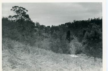
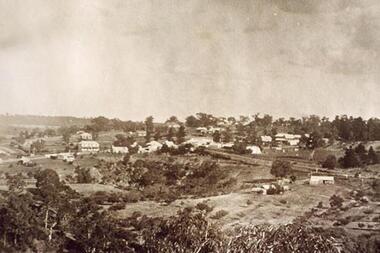
Photograph - Digital image, View over Greensborough from Sondemeyer's Hill, 1925c
Early 20th century view of Greensborough showing the rural nature of the area at this time.Digital copy of sepia photograph.greensborough -
 Greensborough Historical Society
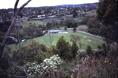
Photograph - Digital Image, Greensborough View over Partington's Flat, 1983c
View of Greensborough and Club House in Partington's Flat in1983 [Faye Partington's Date] .Digital copy of colour photograph.greensborough -
![Photograph - Digital image, Greensborough Cemetery [view 5], 08/03/2012](/media/collectors/4f729f5697f83e03086015b8/items/54c4afd22162f1070475eca3/item-media/54c4b0222162f1070475f0d9/item-fit-380x285.jpg) Greensborough Historical Society
Greensborough Historical SocietyPhotograph - Digital image, Greensborough Cemetery [view 5], 08/03/2012
View of Greensborough Cemetery on 8/3/2012. Photograph taken by Jasmin Burge.Greensborough Cemetery was created when land was given for the cemetery by Mr William Poulter, a local settler, about 1864. The cemetery holds the graves of many of the early settlers in the district. The cemetery holds approximately 250 grave sites with 350 people buried there. Digital copy of colour photograph of cemetery.greensborough cemetery -
![Photograph - Digital image, Greensborough Cemetery [view 6], 26/07/2011](/media/collectors/4f729f5697f83e03086015b8/items/54c4b0aa2162f1070475f8a9/item-media/54c4b0df2162f1070475fb80/item-fit-380x285.jpg) Greensborough Historical Society
Greensborough Historical SocietyPhotograph - Digital image, Greensborough Cemetery [view 6], 26/07/2011
View of Greensborough Cemetery 26/07/2011. Photograph taken by Jasmin Burge.Greensborough Cemetery was created when land was given for the cemetery by Mr William Poulter, a local settler, about 1864. The cemetery holds the graves of many of the early settlers in the district. The cemetery holds approximately 250 grave sites with 350 people buried there. This photo captures the grave of Giles Poulter.Digital copy of colour photograph of cemetery.greensborough cemetery -
![Photograph - Digital image, Greensborough Cemetery [view 7], 04/10/2011](/media/collectors/4f729f5697f83e03086015b8/items/54c4b1412162f107047606db/item-media/54c4b1702162f10704760d3a/item-fit-380x285.jpg) Greensborough Historical Society
Greensborough Historical SocietyPhotograph - Digital image, Greensborough Cemetery [view 7], 04/10/2011
View of Greensborough Cemetery 04/10/2011. Photograph taken by Jasmin Burge.Greensborough Cemetery was created when land was given for the cemetery by Mr William Poulter, a local settler, about 1864. The cemetery holds the graves of many of the early settlers in the district. The cemetery holds approximately 250 grave sites with 350 people buried there. Digital copy of colour photograph of cemetery.greensborough cemetery -
![Photograph - Digital image, Greensborough Cemetery [view 2], 08/03/2012](/media/collectors/4f729f5697f83e03086015b8/items/54c4b1cd2162f10704761367/item-media/54c4b1fd2162f1070476170e/item-fit-380x285.jpg) Greensborough Historical Society
Greensborough Historical SocietyPhotograph - Digital image, Greensborough Cemetery [view 2], 08/03/2012
View of Greensborough Cemetery 08/03/2012. Photograph taken by Jasmin Burge.Greensborough Cemetery was created when land was given for the cemetery by Mr William Poulter, a local settler, about 1864. The cemetery holds the graves of many of the early settlers in the district. The cemetery holds approximately 250 grave sites with 350 people buried there. Digital copy of colour photograph of cemetery.greensborough cemetery -
![Photograph - Digital image, Greensborough Cemetery [view 3], 26/07/2011](/media/collectors/4f729f5697f83e03086015b8/items/54c4b25a2162f10704761bfa/item-media/54c4b2882162f10704761e1b/item-fit-380x285.jpg) Greensborough Historical Society
Greensborough Historical SocietyPhotograph - Digital image, Greensborough Cemetery [view 3], 26/07/2011
View of Greensborough Cemetery 26/07/2011. Photograph taken by Jasmin Burge.Greensborough Cemetery was created when land was given for the cemetery by Mr William Poulter, a local settler, about 1864. The cemetery holds the graves of many of the early settlers in the district. The cemetery holds approximately 250 grave sites with 350 people buried there. Digital copy of colour photograph of cemetery.greensborough cemetery -
![Photograph - Digital image, Greensborough Cemetery [view 4], 26/07/2011](/media/collectors/4f729f5697f83e03086015b8/items/54c4b2e12162f10704762248/item-media/54c4b30e2162f107047625ec/item-fit-380x285.jpg) Greensborough Historical Society
Greensborough Historical SocietyPhotograph - Digital image, Greensborough Cemetery [view 4], 26/07/2011
View of Greensborough Cemetery 26/07/2011. Photograph taken by Jasmin Burge.Greensborough Cemetery was created when land was given for the cemetery by Mr William Poulter, a local settler, about 1864. The cemetery holds the graves of many of the early settlers in the district. The cemetery holds approximately 250 grave sites with 350 people buried there. Digital copy of colour photograph of cemetery.greensborough cemetery -
![Photograph - Digital image, Greensborough Cemetery [view 8], 26/07/2011](/media/collectors/4f729f5697f83e03086015b8/items/54c4b51b2162f1070476504c/item-media/54c4b54c2162f107047653e7/item-fit-380x285.jpg) Greensborough Historical Society
Greensborough Historical SocietyPhotograph - Digital image, Greensborough Cemetery [view 8], 26/07/2011
View of Greensborough Cemetery 26/07/2011. Photograph taken by Jasmin Burge.Greensborough Cemetery was created when land was given for the cemetery by Mr William Poulter, a local settler, about 1864. The cemetery holds the graves of many of the early settlers in the district. The cemetery holds approximately 250 grave sites with 350 people buried there. Digital copy of colour photograph of cemetery.greensborough cemetery -
 Greensborough Historical Society
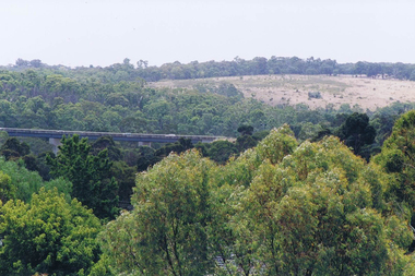
Photograph - Digital image, Frank Solomon, View over Greensborough to Plenty River Drive bridge, 2010c
View over trees to the Greensborough By-pass bridge over Plenty River Drive.Digital copy of colour photographplenty river drive, greensborough bypass -
 Eltham District Historical Society Inc
Photograph, Hugh Fisher, Eltham - View of Council Chamber, 1965
View of the Council Chamber in the brand new Eltham Shire Office opened in 1965.This photo forms part of a collection of photographs gathered by the Shire of Eltham for their centenary project book,"Pioneers and Painters: 100 years of the Shire of Eltham" by Alan Marshall (1971). The collection of over 500 images is held in partnership between Eltham District Historical Society and Yarra Plenty Regional Library (Eltham Library) and is now formally known as the 'The Shire of Eltham Pioneers Photograph Collection.' It is significant in being the first community sourced collection representing the places and people of the Shire's first one hundred years.Digital imagesepp, shire of eltham pioneers photograph collection, eltham, eltham shire office, council chamber -
 St Kilda Historical Society
Photograph - Bundalohn, Graeme S Breydon, Rear view, 6 Tennyson St, St Kilda, 3/08/1974
Photograph of Rear view, 6 Tennyson St, St Kilda, showing additionsblack and white photograph, unmounted, original, good condition -
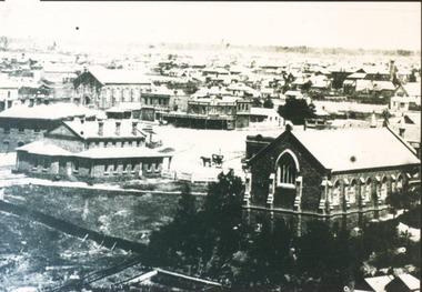 City of Ballarat Libraries
Photograph, View south west to Grant, Armstrong and Lydiard Streets circa 1876
This photo shows the rear view of the Court House, Methodist Church and Ebenezer Church.building, court house, methodist church, ebenezer church, public, grant street, armstrong street, lydiard street