Showing 576 items matching "yarra yarra district"
-
 Marysville & District Historical Society
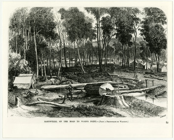
Work on paper (item) - Print of wood engraving, Frederick Grosse et al, Marysville, on the road to Wood's Point, 27-11-1866
A copy of an early wood engraving taken from a photograph of the township of Marysville in Victoria.A copy of an early wood engraving taken from a photograph of the township of Marysville in Victoria. The Yarra Track is the former name of the gold fields road from Healesville to the Woods Point and Jordan Goldfields in Victoria.victoria, frederick grosse, albert charles cooke, thomas waters, wood engraving, marysville, wood's point road -
 Marysville & District Historical Society
Document (Item) - Report, John F. Waghorn, Yarra Track, Unknown
A report on the history of the Yarra Track by John Waghorn, a local amateur historian.A report on the history of the Yarra Track by John Waghorn, a local amateur historian. John Waghorn was an amateur historian, an authority on the history of Victoria's postal services. He could tell you how mail was delivered in the high country in the 1880s, where the town of Gobur was, or when the overland Melbourne-Sydney mail service began. He admitted that his hobby has got a little out of hand. He had 30 filing cabinets, and indexes of more than 70,000 postal workers over the past 160 years crammed into three rooms at his home. If an ancestor was a postmaster in a Victorian town, he may have been able to reveal the person's occupation, income and working conditions.yarra track, john waghorn, victoria's postal services, wood's point, sydney road, longwood, merton, mansfield, postmasters, bonnie doon, melville merton mansfield, eltham, healesville, marysville, walhalla, melbourne-warburton-wood's point line, loose bags, heidelberg post office, eltham post office, kangaroo ground post office, yarra glen post office, marysville post office, healesville post office, mansfield post office, jamieson post office, gaffney's creek post office, wood's point post office, postal department, george rieck, stockman, jones, beecher, stockman's reward, big river, mary mcdonald, upper yarra river, donovan's creek, cornelius donovan, bridget buggy, matlock, alexandra, william farrell, jordan diggings, new chum, watts river, black spur, narbethong, granton, acheron river, mount strickland, paradise plains, mount grant, mount arnold, jordan goldfields, william robley, robley's spur, big river crossing, great dividing range, cumberland valley, james mcguigan, w elliot, christopher harrison, james marsh, cobb and co, box hill, lilydale, fehrings, koehlers, shaws, bear creek, cairnsville, cumberland creek, walkers, golden bower mine, collins' mountain home hotel, walsh's creek post office, rosa mcveigh, frank barton, hitchins, matthew kennedy, william morris, e r nichols, t woods, tom burchell, peter kerr, henry kuyper, william podlech, george koehler, henry brockmann, henry petty, thomas smith, jacob butchart, john perry, slingsby davis, royal mail hotel, walter gray, john summers, travellers rest hotel, lockington, the oaks, the springs, st clair, thomas crawford, springvale hotel, john sinclair, saint clair hotel, gould, mathews, willie we have missed you hotel, germany, johan fehring, adelaide, linton, ballarat, gunbower, murray river, anna katerina fehring, 1890s depression, land boom, fehring place, fred baker, alf sparke, fehring's hotel, mcveigh's hotel, wood's point mountaineer, l cox, victorian country directories, letson cox, coburg, maria hayes, setson, fitzroy, richmond, john cox, jordan river, jericho, e. norris, le poidevin, newell, o'brien, alhambra, sinclair, parker, ellis, tripp, quin, vernon, thompson, charsley, james fahie, george locke, william chester, chesterville, kirwan, cumberland reserve, blue spruce, e.s. and a bank, selby joyce, selby charles joy, selby joseph joyce -
Marysville & District Historical Society
Document (Item) - Document-Table, Judith Vimpani, Yarra Track Hostelries- Marysville to Woods Point, Unknown
A document outlining all the hostelries that existed along the Yarra Track between Marysville and Wood's Point.A document outling all the hostelries that existed along the Yarra Track between Marysville and Wood's Point.yarra track, marysville, wood's point, woods point, fernshaw, paradise plains, black spur, mount grant, george edwards, walker family, melbourne, new chum, hit & miss restaurant, mr clifford, michael woods, glen watts, tri bhean hotel, ewen cameron, ewen hugh cameron, thomas barton, butler's wood's point directory, globe hotel, swanston street, mount juliet, ben more & c, jordan district, jefferson's watts bridge inn, matthew jefferson, reefer's hotel, boyle's hotel, william henry johnson, samuel boyle, black spur hotel, fisher's creek, narbethong, fisher's home hotel, black spur inn, frederick fisher, william hodson, wood's point road, acheron river, acheron bridge hotel, john robson, granton, clifford, wilks creek, wilks creek hotel, patrick maloney, steavenson, marysville hotel, australian hotel, junction hotel, the dutchman's restaurant, henry kuyper, william podlech, mount arnold, mount arnold hotel, charles schultz, james toohey, john gleeson, joy burchall, ian newman, henry brockman, belle isle, belle elle, bellell creek, upper yarra, guerin's bridge, bell's hotel, henry petty, celia moran, ruth petty, cumberland creek, cumberland creek store and restaurant, cumberland creek hotel, charles edwin hargreaves, annie hargreaves, urina hargreaves, alice hargreaves, healesville, josiah hargreaves, henderson drysdale, henry whelan, halfway house, thomas smith, svendson, gosling, donovans creek, chesterville, perry's hotel, john perry, perry's coach and horses hotel, edward courtney, scandinavian hotel, the swede's, walker's hotel, jacob burchart, golden fleece, theodore kappler, george koehler's hotel, david walker, millicent walker, elsie jowett, bill walker, big river, royal mail hotel, shaw's, slingsby davies, edwin jones, elizabeth jane parker, sandridge, archibald charles edwin jones, matlock, alexander myers, frank berwick frederick jones, ned jones, jennie jones, sophie milllicent parker jones, thomas shaw, dorothy walker, travellers rest hotel, reefton, summers, john fehring, f fehring, katerina fehring, john christoph blumeyer, anne fehring, john baker, evelyn observer, anna katrina baker, hannah catherine baker, john frederick baker, mcmahon's creek, oaks, the springs, st clair, sinclair's valley, mountain home hotel, neilson, collins, waters, jan emma sinclair, john sinclair, mr cox, peter sinclair, willie we have missed you hotel, spring vale hotel, robert matthews, thomas crawford -
 Marysville & District Historical Society
Photograph (Item) - Black and white photograph, Way to Cumberland Falls, c1900
An early black and white photograph of the forest near the Cumberland Falls in Victoria.An early black and white photograph of the forest near the Cumberland Falls in Victoria. The falls are located on the Marysville-Wood's Point Road. Cambarville is notable for its giant mountain ash (Eucalyptus regnans) trees within the Cumberland Memorial Scenic Reserve, and relics from former sawmills and gold mining. The Big Culvert is located nearby on the Marysville - Woods Point Road, which was historically part of the Yarra Track. Cambarville was established as a timber mill town in the 1940s. Timber mill owners A Cameron and FJ Barton named Cambarville. They established the mill to salvage timber from trees destroyed in the 1939 bushfires. Cambarville was impacted by the 2009 Black Saturday bushfires and any remaining structures were destroyed.ARMSTRONG COLLECTION 42 STATION STREET/ SANDRINGHAM 3191/ TEL. (03) 9521 5442/ IAN M.L. ARMSTRONG OAMcumberland falls, cambarville, marysville, victoria, waterfalls, postcard, souvenir, mountain ash, mining, timber mills, big culvert, yarra track, a cameron, fj barton, black saturday bushfires, 1939 bushfires, eucalyptus regnans -
 Marysville & District Historical Society
Photograph (Item) - Black and white photograph, Cumberland Falls, c1900
An early black and white photograph of Cumberland Falls near Marysville in Victoria.An early black and white photograph of Cumberland Falls near Marysville in Victoria. These falls are located on the Marysville-Wood's Point Road. Cambarville is notable for its giant mountain ash (Eucalyptus regnans) trees within the Cumberland Memorial Scenic Reserve, and relics from former sawmills and gold mining. The Big Culvert is located nearby on the Marysville - Woods Point Road, which was historically part of the Yarra Track. Cambarville was established as a timber mill town in the 1940s. Timber mill owners A Cameron and FJ Barton named Cambarville. They established the mill to salvage timber from trees destroyed in the 1939 bushfires. Cambarville was impacted by the 2009 Black Saturday bushfires and any remaining structures were destroyed.ARMSTRONG COLLECTION 42 STATION STREET/ SANDRINGHAM 3191/ TEL. (03) 9521 5442/ IAN M.L. ARMSTRONG OAMcumberland falls, cambarville, marysville, victoria, waterfalls, postcard, souvenir, mountain ash, mining, timber mills, big culvert, yarra track, a cameron, fj barton, black saturday bushfires, 1939 bushfires, eucalyptus regnans -
 Marysville & District Historical Society
Photograph (Item) - Black and white photograph, Yarra Track Hotel, c1900
An early black and white photograph of a hotel along the Yarra Track.An early black and white photograph of a hotel along the Yarra Track. The Yarra Track is the former name of the gold fields road from Healesville to the Woods Point and Jordan Goldfields, in Victoria, Australia. A direct route via the Yarra River and the Great Divide was discovered by Rieck in September 1862 and became known as the Yarra Track. Early in 1863, the Victorian Government decided to construct a 193-kilometre (120 mile) road along the route. Its original width varied between 4 and 6 metres (12 and 20 feet), and was designed to accommodate horse-drawn vehicles. The Track involved the climbing of the Black Spur, descent into the Acheron Valley, and then through Marysville to the Cumberland where it followed the existing route. Unable to ascertain both the location and name of hotel.ARMSTRONG COLLECTION 42 STATION STREET/ SANDRINGHAM 3191/ TEL. (03) 9521 5442/ IAN M.L. ARMSTRONG OAMyarra track, healesville, wood's point, jordan goldfields, victoria, yarra river, great divide, reick, black spur, acheron valley, marysville, cumberland creek -
 Marysville & District Historical Society
Photograph (Item) - Black and white photograph, The "Scandinavians' - (Deserted), c1900
An early black and white photograph of The Scandinavian's Hotel and Boarding House along the Yarra Track.An early black and white photograph of The Scandinavian's Hotel and Boarding House along the Yarra Track. The Yarra Track is the former name of the gold fields road from Healesville to the Woods Point and Jordan Goldfields, in Victoria, Australia. A direct route via the Yarra River and the Great Divide was discovered by Rieck in September 1862 and became known as the Yarra Track. Early in 1863, the Victorian Government decided to construct a 193-kilometre (120 mile) road along the route. Its original width varied between 4 and 6 metres (12 and 20 feet), and was designed to accommodate horse-drawn vehicles. The Track involved the climbing of the Black Spur, descent into the Acheron Valley, and then through Marysville to the Cumberland where it followed the existing route.ARMSTRONG COLLECTION 42 STATION STREET/ SANDRINGHAM 3191/ TEL. (03) 9521 5442/ IAN M.L. ARMSTRONG OAMthe scandinavians', yarra track, healesville, wood's point, jordan goldfields, victoria, yarra river, great divide, reick, black spur, acheron valley, marysville, cumberland creek -
 Marysville & District Historical Society
Photograph (Item) - Black and white photograph, Camp Opposite The "Scandinavians', c1900
An early black and white photograph of a camp which was opposite The Scandinavian's Hotel and Boarding House along the Yarra Track.An early black and white photograph of a camp which was opposite The Scandinavian's Hotel and Boarding House along the Yarra Track. The Yarra Track is the former name of the gold fields road from Healesville to the Woods Point and Jordan Goldfields, in Victoria, Australia. A direct route via the Yarra River and the Great Divide was discovered by Rieck in September 1862 and became known as the Yarra Track. Early in 1863, the Victorian Government decided to construct a 193-kilometre (120 mile) road along the route. Its original width varied between 4 and 6 metres (12 and 20 feet), and was designed to accommodate horse-drawn vehicles. The Track involved the climbing of the Black Spur, descent into the Acheron Valley, and then through Marysville to the Cumberland where it followed the existing route.ARMSTRONG COLLECTION 42 STATION STREET/ SANDRINGHAM 3191/ TEL. (03) 9521 5442/ IAN M.L. ARMSTRONG OAMthe scandinavians', yarra track, healesville, wood's point, jordan goldfields, victoria, yarra river, great divide, reick, black spur, acheron valley, marysville, cumberland creek -
 Marysville & District Historical Society
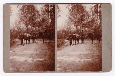
Photograph (Item) - Black and white bi-focal image, Unknown
An early black and white bi-focal image of men and packhorses on the Marysville-Wood's Point Road in Marysville in Victoria.An early black and white bi-focal image of men and packhorses on the Marysville-Wood's Point Road in Marysville in Victoria. This is now known as the Marysville-Wood's Point Road. The Marysville-Woods Point Road was originally part of the Yarra Track, constructed in the early 1860s to provide access between Healesville and the Woods Point Goldfields. Despite the steep terrain and engineering difficulties, the Yarra Track soon became a busy route used by pack horses, horse-drawn drays, and wagons. Today this sealed mountain road is a popular scenic drive between Marysville and Warburton.Packhorses on Wood'spoint Road/ Marysville/ Victoriapackhorses, wood's point road, marysville-wood's point road, marysville, victoria, yarra track, healesville, wood's point goldfields, warburton -
Marysville & District Historical Society
Document (Item) - Newspaper article, The Argus, New Tourist Road. Marysville to Wood's Point Magnificent Forest Scenery, 02-1924
A newspaper article regarding the opening of the Marysville-Wood's Point Road in February 1924.A newspaper article regarding the opening of the Marysville-Wood's Point Road in February 1924. The Marysville-Woods Point Road was originally part of the Yarra Track, constructed in the early 1860s to provide access between Healesville and the Woods Point Goldfields. Despite the steep terrain and engineering difficulties, the Yarra Track soon became a busy route used by pack horses, horse-drawn drays, and wagons. Today this sealed mountain road is a popular scenic drive between Marysville and Warburton.marysville-wood's point road, yarra track, healesville, wood's point goldfields, warburton, the argus -
 Marysville & District Historical Society
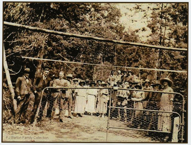
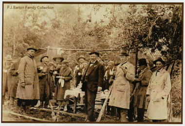
Photograph (Item) - Black and white photograph, 05-02-1924
An early black and white photograph of the ceremonial re-opening of the Marysville-Wood's Point Road in 1924.An early black and white photograph of the ceremonial re-opening of the Marysville-Wood's Point Road in 1924. The Marysville-Woods Point Road was originally part of the Yarra Track, constructed in the early 1860s to provide access between Healesville and the Woods Point Goldfields. Despite the steep terrain and engineering difficulties, the Yarra Track soon became a busy route used by pack horses, horse-drawn drays, and wagons. Today this sealed mountain road is a popular scenic drive between Marysville and Warburton.F.J. Barton Family Collectionmarysville-wood's point road, marysville, wood's point goldfields, healesville, yarra track, warburton -
 Marysville & District Historical Society
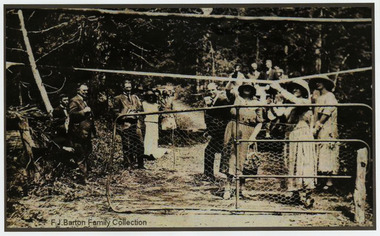
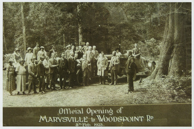
Photograph (Item) - Black and white photograph, Official Opening of MARYSVILLE to WOODSPOINT RD 5th Feb, 1923, 05-02-1924
An early black and white photograph which was taken after the ceremonial re-opening of the Marysville-Wood's Point Road in 1924. The date of 1923 on the photograph is incorrect.An early black and white photograph which was taken after the ceremonial re-opening of the Marysville-Wood's Point Road in 1924. The date of 1923 on the photograph is incorrect. The Marysville-Woods Point Road was originally part of the Yarra Track, constructed in the early 1860s to provide access between Healesville and the Woods Point Goldfields. Despite the steep terrain and engineering difficulties, the Yarra Track soon became a busy route used by pack horses, horse-drawn drays, and wagons. Today this sealed mountain road is a popular scenic drive between Marysville and Warburton.Official Opening of/ MARYSVILLE to WOODSPOINT RD/ 5th Feb, 1923marysville-wood's point road, marysville, wood's point goldfields, healesville, yarra track, warburton, the argus -
Marysville & District Historical Society
Document (Item) - Research Document, Judith Vimpani, William Cavanagh Farrell (1844-1901), 04-2020
An account of the life of William Cavanagh Farrell.An account of the life of William Cavanagh Farrell who was important to Marysville as his review in 1863 of the routes to Wood's Point led to the Yarra Track ascending the Black Spur and going on to what became the resort town of Marysville on the Steavenson River. The Yarra Track is the former name of the gold fields road from Healesville to the Woods Point and Jordan Goldfields, in Victoria, Australia. A direct route via the Yarra River and the Great Divide was discovered by Reick in September 1862 and became known as the Yarra Track. Early in 1863, the Victorian Government decided to construct a 193-kilometre (120 mile) road along the route. Its original width varied between 4 and 6 metres (12 and 20 feet), and was designed to accommodate horse-drawn vehicles. The Track involved the climbing of the Black Spur, descent into the Acheron Valley, and then through Marysville to the Cumberland where it followed the existing route.willaim cavanagh farrell, marysville, victoria, wood's point, yarra track, black spur, steavenson's creek, steavenson river, george theodore rieck -
Marysville & District Historical Society
Document (Item) - Research Document, Judith Vimpani, George Theodore Rieck (1833-pos 1884), 04-2020
An account of the life of George Theodore Rieck.An account of the life of George Theodore Rieck. The Yarra Track is the former name of the gold fields road from Healesville to the Woods Point and Jordan Goldfields, in Victoria, Australia. A direct route via the Yarra River and the Great Divide was discovered by Rieck in September 1862 and became known as the Yarra Track. Early in 1863, the Victorian Government decided to construct a 193 kilometre (120 mile) road along the route. Its original width varied between 4 and 6 metres (12 and 20 feet), and was designed to accommodate horse-drawn vehicles. The Track involved the climbing of the Black Spur, descent into the Acheron Valley, and then through Marysville to the Cumberland where it followed the existing route.george theordore rieck, marysville, victoria, james murphy, new chum creek, wood's point, gold mining, matlock, walhalla, yarra track -
 Marysville & District Historical Society
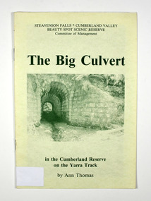
Booklet - Paperback booklet, Ann Thomas, The Big Culvert, 1992
A history of the Big Culvert in the Cumberland Reserve and its link to the Yarra Track.Paperback. Front cover has an old photograph of the big culvert.non-fictionA history of the Big Culvert in the Cumberland Reserve and its link to the Yarra Track.big culvert, cumberland reserve, yarra track, victoria, history -
Marysville & District Historical Society
Booklet (Item) - Information booklet, Artworkz Tourism, The Big Culvert, Unknown
An information booklet that was produced as a guide to The Big Culvert.An information booklet that was produced as a guide to The Big Culvert. The Big Culvert is a historic granite and bluestone arch along the Yarra Track, a major route to Melbourne through the 1800s. Built in 1870 and a major piece of infrastructure for its time, the heritage listed culvert allowed water to flow under often-flooded the road. The Yarra Track is the former name of the gold fields road from Healesville to the Woods Point and Jordan Goldfields, in Victoria, Australia. A direct route via the Yarra River and the Great Divide was discovered by Rieck in September 1862 and became known as the Yarra Track. Early in 1863, the Victorian Government decided to construct a 193-kilometre (120 mile) road along the route. Its original width varied between 4 and 6 metres (12 and 20 feet), and was designed to accommodate horse-drawn vehicles. The Track involved the climbing of the Black Spur, descent into the Acheron Valley, and then through Marysville to the Cumberland where it followed the existing route.the big culvert, yarra track, victoria, healesville, wood's point goldfields, jordan goldfields, black spur, acheron valley, cumberland valley -
Marysville & District Historical Society
Flyer (Item) - Information flyer, Artworkz Tourism, The Big Culvert, 26-03-2016
An information flyer that was produced as a guide to The Big Culvert.An information flyer that was produced as a guide to The Big Culvert. The Big Culvert is a historic granite and bluestone arch along the Yarra Track, a major route to Melbourne through the 1800s. Built in 1870 and a major piece of infrastructure for its time, the heritage listed culvert allowed water to flow under often-flooded the road. The Yarra Track is the former name of the gold fields road from Healesville to the Woods Point and Jordan Goldfields, in Victoria, Australia. A direct route via the Yarra River and the Great Divide was discovered by Rieck in September 1862 and became known as the Yarra Track. Early in 1863, the Victorian Government decided to construct a 193-kilometre (120 mile) road along the route. Its original width varied between 4 and 6 metres (12 and 20 feet), and was designed to accommodate horse-drawn vehicles. The Track involved the climbing of the Black Spur, descent into the Acheron Valley, and then through Marysville to the Cumberland where it followed the existing route.the big culvert, yarra track, victoria, healesville, wood's point goldfields, jordan goldfields, black spur, acheron valley, cumberland valley -
 Marysville & District Historical Society
Photograph (Item) - Black and white photograph, Unknown
A black and white photograph taken at the unveiling of the sign placed at The Big Culvert.A black and white photograph taken at the unveiling of the sign placed at The Big Culvert. The Big Culvert is a historic granite and bluestone arch along the Yarra Track, a major route to Melbourne through the 1800s. Built in 1870 and a major piece of infrastructure for its time, the heritage listed culvert allowed water to flow under often-flooded the road. The Yarra Track is the former name of the gold fields road from Healesville to the Woods Point and Jordan Goldfields, in Victoria, Australia. A direct route via the Yarra River and the Great Divide was discovered by Rieck in September 1862 and became known as the Yarra Track. Early in 1863, the Victorian Government decided to construct a 193-kilometre (120 mile) road along the route. Its original width varied between 4 and 6 metres (12 and 20 feet), and was designed to accommodate horse-drawn vehicles. The Track involved the climbing of the Black Spur, descent into the Acheron Valley, and then through Marysville to the Cumberland where it followed the existing route.Unveiling of sign/ at "Big Culvert" In front Max Cockerrell and - Rear: second back Geoff Pope R.H.S. rear: Nancy "/ Anne "the big culvert, yarra track, victoria, healesville, wood's point goldfields, jordan goldfields, black spur, acheron valley, cumberland valley -
 Marysville & District Historical Society
Photograph (Item) - Colour photograph, 20-09-2008
A colour photograph of the entrance to The Big Culvert.A colour photograph of the entrance to The Big Culvert. The Big Culvert is a historic granite and bluestone arch along the Yarra Track, a major route to Melbourne through the 1800s. Built in 1870 and a major piece of infrastructure for its time, the heritage listed culvert allowed water to flow under often-flooded the road. The Yarra Track is the former name of the gold fields road from Healesville to the Woods Point and Jordan Goldfields, in Victoria, Australia. A direct route via the Yarra River and the Great Divide was discovered by Rieck in September 1862 and became known as the Yarra Track. Early in 1863, the Victorian Government decided to construct a 193-kilometre (120 mile) road along the route. Its original width varied between 4 and 6 metres (12 and 20 feet), and was designed to accommodate horse-drawn vehicles. The Track involved the climbing of the Black Spur, descent into the Acheron Valley, and then through Marysville to the Cumberland where it followed the existing route.the big culvert, yarra track, victoria, healesville, wood's point goldfields, jordan goldfields, black spur, acheron valley, cumberland valley -
 Marysville & District Historical Society
Booklet - Information booklet, Ann Thomas, Wilks Creek Bridge, 1993
A history of the Wilks Creek Bridge and its connection to the Yarra Track.Paperback. Front cover has an old photograph of the Wilks Creek Bridge.non-fictionA history of the Wilks Creek Bridge and its connection to the Yarra Track.wilks creek bridge, yarra track, narbethong, marysville, victoria, clement wilks, wood's point goldfields, jordan goldfields, john monash, monash and anderson, 2009 black saturday bushfires -
 Marysville & District Historical Society
Photograph (Item) - Colour photograph, Pre 2009
A colour photograph of the Wilks Creek Bridge near Marysville in Victoria.A colour photograph of the Wilks Creek Bridge near Marysville in Victoria. The Wilks Creek Bridge is a former timber and bluestone road bridge on the Yarra Track, and is located just off the Black Spur route, between Narbethong and Marysville, Victoria, Australia. It was built in 1870 to the design of colonial Public Works Department engineer Clement Wilks as part of the construction of a new road to the Woods Point and Jordan Goldfields. Like many bridges of the period, it had a timber superstructure employing squared beams supported by struts and straining pieces, on cut bluestone abutments. The bridge was remodelled around 1900 by engineer John Monash of the famous bridge-engineering firm of Monash and Anderson. It was last used for heavy vehicular traffic in 1980 following the realignment of Marysville Road, and was left to decay until its demolishment in 2008. All timber traces of the bridge were destroyed in the 2009 Black Saturday fires. The handcrafted bluestone masonry wingwalls and abutments, especially shaped to receive timber struts, rate among the earliest of its kind surviving intact in Victoria.wilks creek bridge, yarra track, narbethong, marysville, victoria, clement wilks, wood's point goldfields, jordan goldfields, john monash, monash and anderson, 2009 black saturday bushfires -
 Marysville & District Historical Society
Photograph (Item) - Black and white photograph, 1993
A black and white photograph taken at the re-opening of the Wilks Creek Bridge picnic area and launch of Ann Thomas' book Wilks Creek Bridge.A black and white photograph taken at the re-opening of the Wilks Creek Bridge picnic area and launch of Ann Thomas' book Wilks Creek Bridge. The Wilks Creek Bridge is a former timber and bluestone road bridge on the Yarra Track, and is located just off the Black Spur route, between Narbethong and Marysville, Victoria, Australia. It was built in 1870 to the design of colonial Public Works Department engineer Clement Wilks as part of the construction of a new road to the Woods Point and Jordan Goldfields. Like many bridges of the period, it had a timber superstructure employing squared beams supported by struts and straining pieces, on cut bluestone abutments. The bridge was remodelled around 1900 by engineer John Monash of the famous bridge-engineering firm of Monash and Anderson. It was last used for heavy vehicular traffic in 1980 following the realignment of Marysville Road, and was left to decay until its demolishment in 2008. All timber traces of the bridge were destroyed in the 2009 Black Saturday fires. The handcrafted bluestone masonry wingwalls and abutments, especially shaped to receive timber struts, rate among the earliest of its kind surviving intact in Victoria.wilks creek bridge, yarra track, narbethong, marysville, victoria, clement wilks, wood's point goldfields, jordan goldfields, john monash, monash and anderson, 2009 black saturday bushfires -
Marysville & District Historical Society
Document (Item) - Heritage Report, Biosis Research Pty Ltd, Heritage Report-Dismantling of Wilks Creek Brdige Deck Marysville, Unknown
A heritage report on the dismantiling of the Wilks Creek Bridge deck in Marysville in Victoria.A heritage report on the dismantiling of the Wilks Creek Bridge deck in Marysville in Victoria. The Wilks Creek Bridge is a former timber and bluestone road bridge on the Yarra Track, and is located just off the Black Spur route, between Narbethong and Marysville, Victoria, Australia. It was built in 1870 to the design of colonial Public Works Department engineer Clement Wilks as part of the construction of a new road to the Woods Point and Jordan Goldfields. Like many bridges of the period, it had a timber superstructure employing squared beams supported by struts and straining pieces, on cut bluestone abutments. The bridge was remodelled around 1900 by engineer John Monash of the famous bridge-engineering firm of Monash and Anderson. It was last used for heavy vehicular traffic in 1980 following the realignment of Marysville Road, and was left to decay until its demolishment in 2008. All timber traces of the bridge were destroyed in the 2009 Black Saturday fires. The handcrafted bluestone masonry wingwalls and abutments, especially shaped to receive timber struts, rate among the earliest of its kind surviving intact in Victoria.wilks creek bridge, yarra track, narbethong, marysville, victoria, clement wilks, wood's point goldfields, jordan goldfields, john monash, monash and anderson, 2009 black saturday bushfires -
 Eltham District Historical Society Inc
Photograph, Yarra River at Warrandyte, 1990, 1990
Originally contained in a 'magnetic' photo album believed to have been donated by Mr Eric Stephenson, Jingalong, 110 Ryans Road, Eltham, Vic. 3095; relocated to archival safe storage.Two colour photographswarrandyte, yarra river