Showing 57367 items
matching black and white
-
 Eltham District Historical Society Inc
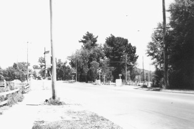
Photograph, Fitzsimons Lane Bridge over Yarra River between Eltham and Templestowe, c.1966, 1966c
The bridge over the Yarra River was initially opened September 22nd, 1961. Newspaper reports at the time of opening stated it linked Bolton Street, Eltham, with Fitzsimons Lane, Templestowe. In 1955 the Country Roads Board (CRB) produced survey plans that showed proposed land acquisition for the future bridge and road approaches. The 1955 plan shows that it was proposed to connect Fitzsimons Lane with Bolton Street in Eltham by a diagonal road across the river. The road connection would then continue along Bolton Street to Main Road. Prior to construction of the bridge the CRB modified the proposal significantly so that there was a new road parallel with Bolton Street and then curving to join Main Road at what was then its intersection with Old Eltham Road. This involved significantly more land acquisition and altered the pattern of land subdivision through this corridor. Initially the new road was just a single two-way carriageway as it would have required a significant widening of the cutting on the Shire of Eltham side of the river. The road was officially un-named but was known locally as the Eltham-Templestowe Road. The 1966 Melway street directory and other 1960s editions also listed the road as the Eltham-Templestowe Road. In December 1970, Eltham Shire Council, in pursuance of the provisions of the Local Government Act, named it Templestowe Road. The road was renamed Fitzsimons Lane around 1984 in conformity with the section south of the river. In 1991 a new bridge was built to the west of the original bridge. Fitzsimons Lane was widened to four traffic lanes although on the Eltham side this was done within the limits of the existing cutting. NEW BRIDGE STARTS THEM EXPLORING Without any fanfares, Country Roads Board workmen on Friday afternoon put the finishing touches to the approaches, removed the barricades, and let the traffic roll over the new Yarra bridge linking Bolton Street, Eltham, with Fitzsimons Lane, Templestowe. Over the week-end many “bridge watchers” who were making one of their periodic inspections of the progress on the new bridge found to their surprise that they could drive over it, so that people who had gone for a run out to Eltham suddenly found themselves wandering through Templestowe and Doncaster. By Monday the word of the bridge’s opening had got around sufficiently for many regular travellers to the city from Eltham and beyond to vary the monotony by going to town via Templestowe and Kew instead of through Heidelberg. They were surprised at the distances – about 3 ½ miles from Eltham to Templestowe, 6 miles from Eltham Shire hall to the Lower Heidelberg Road-Banksia Street intersection. NEW NEIGHBOURS For people on both sides of the river, the new bridge has turned distant friends into near neighbours. A Greensborough man on Sunday took 35 minutes to reach the home of a friend in East Doncaster, but the return trip over the new bridge took only 17 minutes. It will be some time yet before most people work out the possibilities in shorter and quicker trips form the north-eastern areas to the eastern and south-eastern suburbs. The coming of the warmer months will soon teach many, though the short cuts to Peninsular beaches and eastern suburban drive-ins. And before very long it is likely there will be a Tramways bus running from Templestowe to Eltham station. NEW BRIDGE STARTS THEM EXPLORING (1961, September 27). The Diamond Valley News (News clipping held in SEA_74-1_047) The previously un-named road between Main Road and Yarra River, Eltham South, east of Bolton Street was named Templestowe Road, December 15, 1970 NAMING OF STREETS AND ROADS. (1970, December 15). The Diamond Valley News (News clipping held in SEA_74-2_022)Black and white photographManufacturer's marks: Polaroid, Batch #J62K181 (Sep 1966).infrastructure, shire of eltham infrastructure, bridge, fitzsimons lane bridge, polaroid, yarra river -
 Eltham District Historical Society Inc
Photograph, Fitzsimons Lane Bridge over Yarra River between Eltham and Templestowe
The bridge over the Yarra River was initially opened September 22nd, 1961. Newspaper reports at the time of opening stated it linked Bolton Street, Eltham, with Fitzsimons Lane, Templestowe. In 1955 the Country Roads Board (CRB) produced survey plans that showed proposed land acquisition for the future bridge and road approaches. The 1955 plan shows that it was proposed to connect Fitzsimons Lane with Bolton Street in Eltham by a diagonal road across the river. The road connection would then continue along Bolton Street to Main Road. Prior to construction of the bridge the CRB modified the proposal significantly so that there was a new road parallel with Bolton Street and then curving to join Main Road at what was then its intersection with Old Eltham Road. This involved significantly more land acquisition and altered the pattern of land subdivision through this corridor. Initially the new road was just a single two-way carriageway as it would have required a significant widening of the cutting on the Shire of Eltham side of the river. The road was officially un-named but was known locally as the Eltham-Templestowe Road. The 1966 Melway street directory and other 1960s editions also listed the road as the Eltham-Templestowe Road. In December 1970, Eltham Shire Council, in pursuance of the provisions of the Local Government Act, named it Templestowe Road. The road was renamed Fitzsimons Lane around 1984 in conformity with the section south of the river. In 1991 a new bridge was built to the west of the original bridge. Fitzsimons Lane was widened to four traffic lanes although on the Eltham side this was done within the limits of the existing cutting. NEW BRIDGE STARTS THEM EXPLORING Without any fanfares, Country Roads Board workmen on Friday afternoon put the finishing touches to the approaches, removed the barricades, and let the traffic roll over the new Yarra bridge linking Bolton Street, Eltham, with Fitzsimons Lane, Templestowe. Over the week-end many “bridge watchers” who were making one of their periodic inspections of the progress on the new bridge found to their surprise that they could drive over it, so that people who had gone for a run out to Eltham suddenly found themselves wandering through Templestowe and Doncaster. By Monday the word of the bridge’s opening had got around sufficiently for many regular travellers to the city from Eltham and beyond to vary the monotony by going to town via Templestowe and Kew instead of through Heidelberg. They were surprised at the distances – about 3 ½ miles from Eltham to Templestowe, 6 miles from Eltham Shire hall to the Lower Heidelberg Road-Banksia Street intersection. NEW NEIGHBOURS For people on both sides of the river, the new bridge has turned distant friends into near neighbours. A Greensborough man on Sunday took 35 minutes to reach the home of a friend in East Doncaster, but the return trip over the new bridge took only 17 minutes. It will be some time yet before most people work out the possibilities in shorter and quicker trips form the north-eastern areas to the eastern and south-eastern suburbs. The coming of the warmer months will soon teach many, though the short cuts to Peninsular beaches and eastern suburban drive-ins. And before very long it is likely there will be a Tramways bus running from Templestowe to Eltham station. NEW BRIDGE STARTS THEM EXPLORING (1961, September 27). The Diamond Valley News (News clipping held in SEA_74-1_047) The previously un-named road between Main Road and Yarra River, Eltham South, east of Bolton Street was named Templestowe Road, December 15, 1970 NAMING OF STREETS AND ROADS. (1970, December 15). The Diamond Valley News (News clipping held in SEA_74-2_022)Black and white photographinfrastructure, shire of eltham infrastructure, bridge, fitzsimons lane bridge, yarra river -
 Canterbury History Group
Photograph - Canterbury Bowling Club
Canterbury Bowling Clubhouse and GreensBlack and white photographlawn bowls, croquet greens, canterbury baptist church, canterbury gardens -
Canterbury History Group
Photograph - Canterbury Gardens
Canterbury Gardens with bandstandBlack and White photographcanterburygardens, bandstand, canterbury road shops -
Canterbury History Group
Photograph - Balwyn Road Canterbury looking South
Balwyn Road Canterbury looking SouthBlack and White photographbalwyn road, canterbury road, canterbury baptist church, street trees -
Canterbury History Group
Photograph - Maling Road Canterbury
Maling Road looking west from Canterbury RoadBlack and White photographmaling road, maling road shops, canterbury post office, vintage cars, horse trough, telegraph poles -
Canterbury History Group
Photograph - Mr and Mrs Mercy 1925 Golden Wedding Anniversary (50 Years), January 1926
Mercy familyGeorge Mercy 1906-1907 Mayor of Camberwell, builder of Hazeldene, owned 34% of commercial premises in Canterbury in 1925, Canterbury Buildings in Canterbury Road.Black and White photographmercy family, golden wedding anniversary, councillors, hazeldene -
 Canterbury History Group
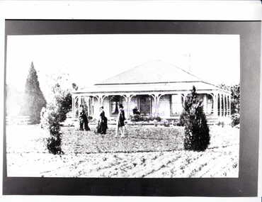
Photograph - Monomeath Homestead, c1880
Front of Monomeath with two ladies and a man walking in the garden and another lady sitting on the front verandah.Black and white photocanterbury, monomeath avenue, monomeath, snowden> e.g, canterbury road -
 Canterbury History Group
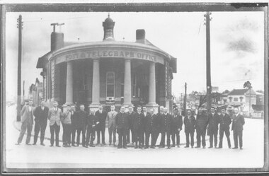
Photograph - Canterbury Post and Telegraph Office and staff, c1930
Engineers, postmen and other staff pose outside Canterbury Post Office in the1930s.black and white photographcanterbury post and telegraph office, canterbury, canterbury road, postal workers -
 Ballarat Tramway Museum
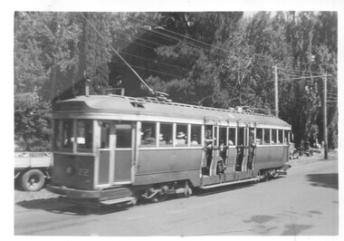
Photograph - Tram No.22 travelling South on Wendouree Parade, c1950
Tram No.22 travelling South on Wendouree Parade. The tram is well loaded with passengers.Yields information about the use of tram 22.Black and white photograph "P"ballarat, ballarat tramways, wendouree parade, lake wendouree, tram 22 -
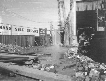
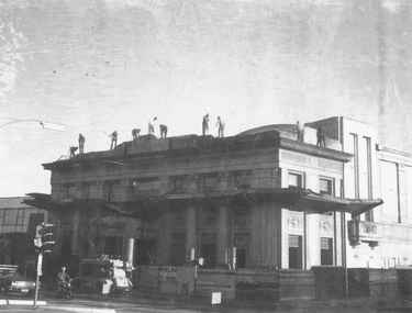
 Ringwood and District Historical Society
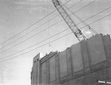
Photograph, Maroondah Highway Central, Ringwood. Demolition of Town Hall, May 1971
Black and white photograph -
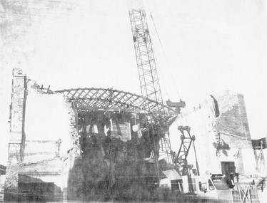
 Ringwood and District Historical Society
Photograph, Maroondah Highway Central, Ringwood. Demolition of Town Hall, May 1971
Black and white photograph -
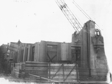
 Ringwood and District Historical Society
Photograph, Maroondah Highway Central, Ringwood. Demolition of Town Hall, May 1971
Black and white photograph -
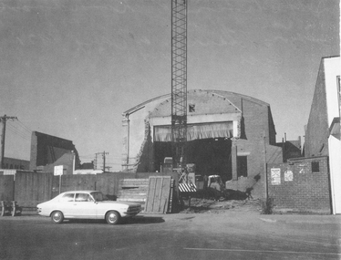
 Ringwood and District Historical Society
Photograph, Maroondah Highway Central, Ringwood. Demolition of Town Hall, May 1971
Black and white photograph. -
 Ringwood and District Historical Society
Photograph, Maroondah Highway Central, Ringwood. Demolition of Town Hall, May1971
Black and white photograph -
 Ringwood and District Historical Society
Photograph, Maroondah Highway Central, Ringwood. Demolition of Town Hall, May 1971
Black and white photograph -
 Ringwood and District Historical Society
Photograph, Maroondah Highway Central, Ringwood. Demolition of Town Hall, May 1971
Black and white photograph -
 Ringwood and District Historical Society
Photograph, Maroondah Highway East, Ringwood- 1969. Looking west towards Ringwood from Mines Road area
Black and white photograph -
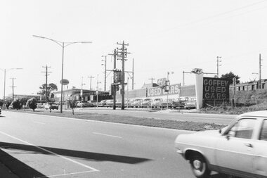 Ringwood and District Historical Society
Photograph, Maroondah Highway East, Ringwood- 1969. Looking east from Alan Coffey used car premises
Black and white photograph -
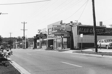 Ringwood and District Historical Society
Photograph, Maroondah Highway East, Ringwood- 1969. Looking east from opposite fire station
Black and white photograph -
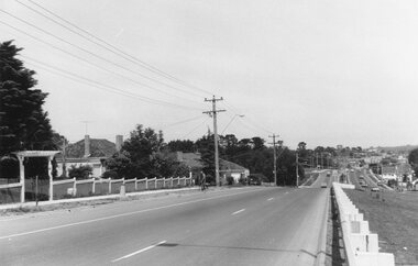
 Ringwood and District Historical Society
Photograph, Maroondah Highway East, Ringwood- 1969. Looking towards Ringwood past Ringwood Lake
Black and white photograph -
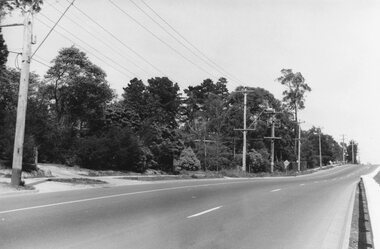
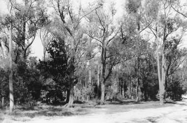 Ringwood and District Historical Society
Photograph, Maroondah Highway East, Ringwood- 1969. Bushland at top end of RingwoodLake
Black and white photograph -
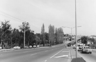
 Ringwood and District Historical Society
Photograph, Maroondah Highway East, Ringwood- 1969. Looking west towards Ringwood approaching Mt Dandenong Road
Black and white photograph -
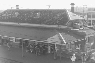 Ringwood and District Historical Society
Photograph, Ringwood railway station No. 1 platform, 1984
Black and white photograph -
 Ringwood and District Historical Society
Photograph, Railway Crossing Bedford Rd Ringwood 1977 looking west
Black and white photographWritten on rear of photo - Rly crossing Bedford Rd Ringwood 1977 -
 Ringwood and District Historical Society
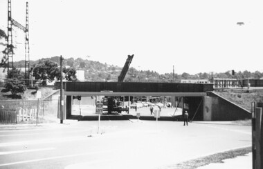
Photograph, Widening of Warrandyte Rd Railway Bridge 1977
Black and white photographWritten on rear of photograph: Widening of Warrandyte Rd Rly Bridge 1977 11/77 B