Showing 15582 items
matching stillwell-valley
-
 Kiewa Valley Historical Society
Saucer Ceramic, Circa 1921
This item was used by the State Electricity Commission of Victoria in their mess huts/rooms for their workers during the construction of the Kiewa Hydro Electricity Scheme. The imprint of the year "1921" was to identify the year that the SECV was formed and relieved the private VHEC (Victorian Hydro-Electric Company). As the scheme was of such a huge, isolated and time consuming nature the feeding of its workers was quite demanding of cutlery and crockery. The use of sturdy English cups and saucers was essential. The period of construction and the isolation of the Kiewa Valley area placed heavy demand for "solid" crockery that could wear abusive handling. This period in time was one when crockery, whether for domestic or commercial use, was imported from "mother" England. This scenario was more so for governmental bodies such as rail, jails and electricity providers than domestic users. The influx of cheaper Asian crockery had not yet begun.This type of crockery item was used by the thousands of SEC Victorian staff and construction workers involved in the building of the Kiewa Hydro Electricity Scheme, over the extensive period (1938 to 1961). This was a period when Government bodies and other semi- government organisations were still tied to the "establishments" of "mother" England. It was a period in Australia's development when the Asian influence was very weak and the established ties to England and Europe was still very strong. The majority of heavy equipment and machinery was either made in England or Europe. Local and European expertise in dam construction and water management in alpine terrain came from migrants for England and Europe. The quality of workmanship from big steel manufacturing plants in England and Europe could not be matched from anywhere else in the developed world. These saucers were used in the mess huts including later in the Bogong mess hall and the Mount Beauty Chalet.This item is a white ceramic saucer (tea /coffee). It is made in England and is of strong and durable ceramic. The bottom cup indent is for either tea or coffee cups of a similar ceramic structure. The 5mm thickness of the ceramic suggests this saucer belongs to a commercial kitchen environment and not domestic. The indent bottom of the saucer is 5mm deep with a side curvature ratio of 2:5. The ceramic is glazed to a commercial standard (worker's mess). See also KVHS 0128 (A to C)The seal of the State Electricity Commission Of Victoria is imprinted on the top inside rim within a curved scroll. Snuggled within the borders of the scroll is a banner with the five stars of the southern cross and an arm with a closed fist projecting from the top with five lightning bolts projecting outwards. On the underside "Vitrified sold by Cafe & Hotel Supplies Pty Ltd Dunn Bennett & Co. Ltd. Burslem Made in England"saucer, plate, secv, state electricity commission of victoria, crockery, mt beauty chalet, bogong mess hall -
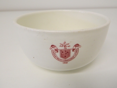 Kiewa Valley Historical Society
Bowl Ceramic, circa mid to late 1900's
This bowl was used by the State Electricity Commission of Victoria in their mess rooms for their workers during the construction of the Kiewa Hydro Electric Scheme. The imprint of the year "1921" was to identify the year that the SECV was formed which relieved the private VHEC (Victorian Hydro-Electric Company). As the scheme was of such a huge scope, isolated and time consuming nature, the feeding of its workers was quite demanding of cutlery and crockery. The use of sturdy English cups and saucers was essential. The period of construction and the isolation of the Kiewa Valley area placed heavy demand for "solid" crockery that could wear abusive handling. This period in time was one when crockery, whether for domestic or commercial use, was imported from "mother" England. This scenario was more so for governmental bodies such as rail, jails and electricity providers than domestic users. The influx of cheaper Asian crockery had not yet begun.This type of crockery item was used by the thousands of SEC Victorian staff and construction workers involved in the building of the Kiewa Hydro Electricity Scheme, over the extensive period (1938 to 1961). This was a period when Government bodies and other semi- government organisations were still tied to the "establishments" of "mother" England. It was a period in Australia's development when the Asian influence was very weak and the established ties to England and Europe was still very strong. The majority of heavy equipment and machinery was either made in England or Europe. Local/European expertise in dam construction and water management in alpine terrain came from migrants and specialist recruited from England and Europe. The quality of workmanship from big steel manufacturing plants in England and Europe could not be matched from anywhere else in the developed world.This item is a white ceramic State Electricity Commission of Victoria bowl. It is made in England and is of strong and durable ceramic. The 5mm thickness of the ceramic suggests this bowl (cereal/soup) belongs to a commercial kitchen environment and not domestic. The indent bottom of the bowl is 5mm deep with a side curvature ratio of 2:5. The ceramic is glazed to a commercial standard (worker's mess). See also KVHS 0128 (B to D) for other ceramic crockery. The seal of the State Electricity Commission of Victoria is imprinted on the top outside rim within a curved scroll and a raised fist with electrical "charges" extending out.. Snuggled within the borders of the scroll is a banner with the five stars of the Southern Cross . On the underside "Vitrified sold by Cafe & Hotel Supplies Pty Ltd Dunn Bennett & Co. Ltd. Burslem Made in England"ceramic crockery, plate, secv, state electricity commission of victoria, crockery, mt beauty chalet, bogong mess hall -
 Eltham District Historical Society Inc
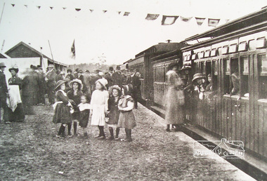
Photograph, Hurstbridge Railway Station, Opening Day, 25 June 1912
Despite inclement weather, up to 500 people attended the opening of the Eltham-Hurstbridge railway on 25 June 1912. Local member of parliament Ewen Cameron and Victorian Premier William Watt were present. Agitation for a railway extension began in 1888 when a meeting was held at Arthurs Creek to press for the construction of a railway line from Heidelberg to Kinglake. The Chairman Mr Charles Draper said this was necessary because this was the best fruit growing district in Victoria. Mr Cameron M.P. pointed out that whatever route the line took it would have to follow the Diamond Valley from Eltham. At the same time another meeting was pressing for the line to be extended to Queenstown (St Andrews). However when detailed surveys were made it was discovered that the only possible route was to Hurstbridge because of the hills. In 1912 the railway was opened terminating at Hurstbridge. Digital filerailway station, hurstbridge -
 Eltham District Historical Society Inc
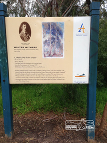
Photograph, Peter Pidgeon, Landscape with sheep by Walter Withers part of the Heidelberg Artist Trail, 2 Sep 2017
The Heidelberg School Artists Trail was established in about 1999 with about 52 signs across four local governemnt areas including Nillumbik and Banyule. This one acknowledges "Landscape with Sheep" by Walter Withers. The text on the board states: Walter Withers depicts in this work a number of sheep on Mr. Tom Orr’s property. Our view is from the rise above this park, from the Lower Plenty side of the nearby Diamond Creek, looking northwards towards the main Eltham township. The area that is now Wingrove Park, would have been to the right, in the valley below the sheep. The mood of this work is warm and vibrant, with the use of strong blues and pinks, and this stands in marked contrast to the softer, cooler greens used by Walter Withers in his work ‘The Silent Gums’. Heritage Excursion by EDHS members - An Eltham South Ramble, 2 Sep 2017Born Digitalactivities, eltham district historical society, eltham south, heritage excursion, local history centre, eltham, heidelberg artists' trail, walter withers, landscape with sheep, wingrove park trail -
 Eltham District Historical Society Inc
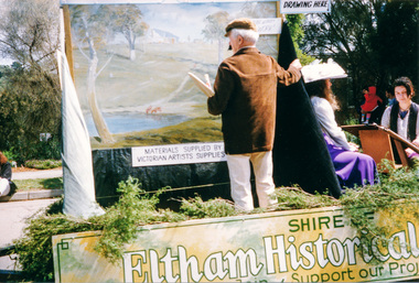
Photograph, Getting ready for the parade, Diamond Street, Eltham Festival, 10 November 1990, 10/11/1990
[from a contemporary report:] The festival parade was held at 11.00 am on Saturday, 10 November 1990, commencing in Youth Road (behind Eltham Railway Station) and Diamond Street. As per tradition, the Shire of Eltham Historical Society entered a float in the parade but for the first time combined with the Diamond Valley Arts Society to produce the float. The theme of the parade was ''Spring into Summer". In accordance with this theme the Society's float depicted artists on a spring painting excursion. Part of the group was "Walter Withers" painting a landscape. There was also another artist painting a portrait of a girl in a spring costume. Joh Ebeli was responsible for preparation of the float. The float won the prize for the best display. Originally contained in a 'magnetic' photo album believed to have been donated by Mr Eric Stephenson, Jingalong, 110 Ryans Road, Eltham, Vic. 3095; relocated to archival safe storage.Colour photograph1990, eltham festival, diamond street, diamond valley arts society, joh ebeli, parade, parade floats, walter withers, youth road -
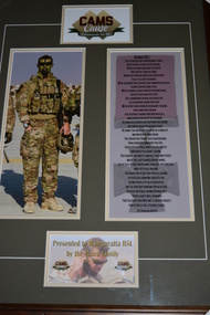 Wangaratta RSL Sub Branch
Framed Photograph, CAMS Cause
Cameron Stewart Baird, VC, MG was a soldier in the Australian Army who was posthumously awarded the Victoria Cross for Australia, the highest award in the Australian honours system. Cameron enlisted on 4/1/2000 and was posted to the 4th Battalion (Commando) RAR now known as the 2nd Commando Regiment. He was deployed on 7 operations including Operation TANAGER - Timor Leste in 2001 Operation BASTILLE and FALCONER - Iraq in 2003. Cameron resigned from the ADF in 2004 re enlisting in 2006 and again posted to 2nd Commando Regiment. In 2007 he was promoted to Lance Corporal and deployed on Operation SLIPPER - Afghanistan. He was awarded the Medal for Gallantry. In 2008 he was promoted to Corporal and deployed again on Operation SLIPPER in 2009 2011 and 2013. He was killed in action on 22 June 2013 and was posthumously awarded the VC for his actions in the Khod Valley Uruzgan province AfghanistanCorporal Baird is the 100th Australian to receive a VC since the award was first created by Queen Victoria in 1856. Brown timber frame and dark green mount containing photograph of soldier alongside poem with image of Victoria Cross medal in backgroundCAMS Cause - Commando for Lifecameron baird, victoria cross, medal for gallantry -
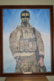 Wangaratta RSL Sub Branch
Framed Painting, Corporal Cameron Baird, VC ,MG
Cameron Stewart Baird, VC, MG was a soldier in the Australian Army who was posthumously awarded the Victoria Cross for his actions in Afghanistan. Cameron enlisted on 4/1/2000 and was posted to the 4th Battalion (Commando) RAR now known as the 2nd Commando Regiment. He was deployed on 7 operations including Operation TANAGER - Timor Leste in 2001 Operation BASTILLE and FALCONER - Iraq in 2003. Cameron resigned from the ADF in 2004 re enlisting in 2006 and again posted to 2nd Commando Regiment. In 2007 he was promoted to Lance Corporal and deployed on Operation SLIPPER - Afghanistan. He was awarded the Medal for Gallantry. In 2008 he was promoted to Corporal and deployed again on Operation SLIPPER in 2009 2011 and 2013. He was killed in action on 22 June 2013 and was posthumously awarded the VC for his actions in the Khod Valley Uruzgan province AfghanistanBrown timber look plastic frame containing watercolour painting in the image of a commando soldier. signature left bottom corner Henk Artplaque - Corporal Cameron Baird, VC ,MG cameron baird, victoria cross -
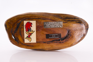 Forests Commission Retired Personnel Association (FCRPA)
Presentation plaque from the "Woodpeckers"
In the post-war era from 1947 to the mid-1980s, the Forests Commission sponsored Australia's only military sawmilling unit, the 91 Forestry Squadron. It was a special reserve unit of the Royal Australian Engineers (RAE). Established and commanded by Commission forester and WW2 veteran, Major Ben Benallack, the "Woodpeckers" as they were known comprised a small pool of specialised soldiers capable of rapid mobilisation in the event of need. Several other Victorian departments such as the State Electricity Commission (SEC) did the same thing who supported a construction squadron based at Newborough in the Latrobe Valley. The scheme created a very active and capable part-time military group that completed many worthy projects across the State. In addition to their military training, the Woodpeckers operated bush sawmills, built timber bridges along the Murray River, the Snake Island Jetty, forest roads and performed various demolition tasks.Presentation plaque from the "Woodpeckers" Mounted on polished wooden burl -
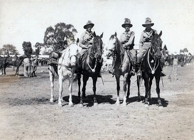 8th/13th Victorian Mounted Rifles Regimental Collection
Photograph
A Hotchkiss Light Machine Gun provided automatic fire support to the Troop. In action a crew of two men manned the gun while the third man took the horses to cover. The 20th Light Horse (Victorian Mounted Rifles) was raised in 1920 as part of the 3rd Cavalry Brigade, 2nd Cavalry Division, Citizen Military Forces, with Headquarters at Seymour and depots along the Goulburn Valley from Mansfield to Tocumwal in southern NSW. In December 1941, 20th Light Horse (Victorian Mounted Rifles) converted from horse to mechanised, initially as 20th Motor Regiment. In 1943 the Regiment was deployed to Merauke, Dutch New Guinea. Upon its return in April 1945, the Regiment was redesignated 20th Pioneer Battalion. It was disbanded following the end of the war. 20th Light Horse was the only light horse regiment to serve overseas in WWII.This is one of a collection of photographs featuring a Light Horse regiment drawn from rural and regional Victoria in the period immediately prior to mobilisation for World War 2 (1939-1945).Black and white photograph mounted on card of three soldiers on horses, one leading a pack horse, being a Hotchkiss Automatic Rifle Section in 20th Light Horse Regiment , circa 1939. -
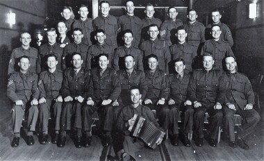 8th/13th Victorian Mounted Rifles Regimental Collection
Photograph
Between 1939 and January 1941, 575 members of rhe 20th Light Horse Regiment enlisted in the 2nd AIF. The Regiment was reinforced with men from all over Victoria called up for compulsory service.The 20th Light Horse (Victorian Mounted Rifles) was raised in 1920 as part of the 3rd Cavalry Brigade, 2nd Cavalry Division, Citizen Military Forces, with Headquarters at Seymour and depots along the Goulburn Valley from Mansfield to Tocumwal in southern NSW. In December 1941, 20th Light Horse (Victorian Mounted Rifles) converted from horse to mechanised, initially as 20th Motor Regiment. In 1943 the Regiment was deployed to Merauke, Dutch New Guinea. Upon its return in April 1945, the Regiment was redesignated 20th Pioneer Battalion. It was disbanded following the end of the war. 20th Light Horse was the only light horse regiment to serve overseas in WWII.This is one of a collection of photographs featuring a Light Horse regiment drawn from rural and regional Victoria in the period immediately prior to mobilisation for World War 2 (1939-1945).Black and white photograph of large group of soldiers arranged in three rows with one man in front with piano accordion." 20th ALH members after enlistment in 2nd AIF 1940."20th light horse, 20th motor regiment -
 Surrey Hills Historical Society Collection
Photograph - Retirement of Mr John Clough as Head Teacher of Surrey Hills Primary School, 1948
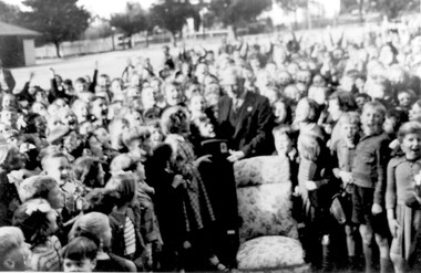
John Spencer Clough was the Head Teacher at Surrey Hills during the Depression and the Second World War years. He had a long history in the education department. He was born in Eaglehawk in 1889; married Lily Carpenter in 1915 and died in Camberwell in 1952. He served in France during the First World War. He enlisted in 1915 (SERN 5671) aged 26; occupation school teacher. Electoral rolls place him at the following places as a school teacher: 1912 - Sea View, Warragul 1913 - Leongatha 1914, 1915, 1916 - Carpendeit 1919 - Portland 1922 - Scarsdale 1925, 1926 - Werribee 1928 - Echuca 1931 - Ballarat 1935 - living Wattle Valley Road, Camberwell. At Surrey Hills he was succeeded by Mr Lewis Wheeler. The girl presenting Mr Clough with his retirement gift was Margaret Haines who made the presentation on behalf of the students. A B&W photo of an elderly gentleman surrounded by children. He is wearing a suit and tie and a girl is presenting him with what looks to be a radio. There is a chair with floral covering central to the photo and the gentleman is standing behind it. The background is consistent with a school playground.Number in pencil on the rear - SH1150surrey hills state school, surrey hills primary school, margaret haines, margaret dowsett, john clough, john spencer clough, education, schools -
 Eltham District Historical Society Inc
Document - Property Binder, 836 Main Road, Eltham
Newspaper article: Was woman found in well put in it? Diamond Valley Local, 16 February 1954, story of wife of baker found in well before Burgoyne family purchased bakery. Newspaper article: Bakery goes ... locals protest, The Valley Voice, 18 July 1979, Joh Ebeli protests about planned destruction, history of building memories of Alistair Knox. Note on demolition of Eltham Bakery building, 1979, by Joh Ebeli who tried to save front of house with friend names Elwers. Photocopy newspaper article: Murder mystery at bakery, History comes to life for old building, 4 November 1979, Harry Burgoyne remembers his grandfather John James Thomas Neville Burgoyne bought bakery in 1896 at time of body found in well, bakery build 1860-1864, sold in 1921. Photocopy newspaper article: Public meeting called over Eltham restaurant proposal, Diamond Valley News, 4 October 1988, protests re proposal for motel and restaurant. Photocopy newspaper article: Fresh tales at an old mine, Diamond Valley News, 4 October 1988, Ausminde Pty Ltd applied for renewal of exploration licence at Old Tree Hill Mine, last mined by Stan Bone and Bill Wallace, photograph of Russell Yeoman at site. Photocopy of line drawing, The Bakery, by Joh Ebeli, 1978. Photocopy of photograph, Old Bakery, next to house built 1880. Photocopy of photograph with Old Bakery in background. On August 12, 1902, appearing before T. Smallman, Esq,. Police Magistrate, and Messrs. W. Duncan and W.J. Taylor, Justices of the Peace is Luther Haley, baker. Wilfred Henry Johnston, by his agent Stanley Ernest Elder had applied for a warrant of ejectment under the Landlord and Tenant Act 1890 against Luther Haley from the bakery premises at the corner of Main Road and York Street. From the evidence presented it is made known that Mrs Burgoyne of Eltham had purchased the property some months earlier from Mr Johnston, which consisted of a store and bakery establishment at Eltham occupied by Mr. Luther Haley, and whose lease expired some little time back, and up to the present time, Mr. Haley was not prepared to leave. He informed the court that he was unable to secure at Eltham a suitable house in which to carry on his business, but he was building a place near the railway station which he expected to be done in about three weeks time, at which time he would give up possession of the bakery. Mr Smallman informed the defendant, Luther Haley, that he would have to quit the premises in three weeks from the present date, and that a warrant of ejectment would be issued. However he also informed Mr Haley that he would order the warrant to lie in the office for three weeks from that date. The premises under construction refered to by Luther Haley in court were situated on the western side of Main Road, near the railway station slightly opposite present day Arthur Street. It was opened around September 1902 as a General Store, Bakery and Tea Rooms. In June 2024 Annie Hackrath shared a memory of living in the old bakery: "My husband and I lived in the old bakery for 18 months in 1978-9 , husband Geoff used the old bakery out the back as a wood workshop, making turnery and handcrafted furniture. The front shop was operated as a “sometimes” art gallery which we called “Gouge and Grain”. There were old sheds against the back fence which we thought were probably stables from the bakery days. Lovely memories of the old place which had so much character and seemed to attract a multitude of interesting creative people! Sad that it was pulled down; a friend salvaged some of the lead light glass in the old doors and included it in a new door panel for us."main road, eltham, property, shops, businesses, eltham bakery, burgoyne family, joh ebeli, alistair knox, harry burgoyne, john james thomas neville burgoyne, one tree hill mine, stan bone miner, bill wallace miner, russell yeoman, henry rech, ausminde pty ltd, john street, bridge street, judy paynter, art gallery, gouge and grain, annie hackrath, geoff hackrath -
 Greensborough Historical Society
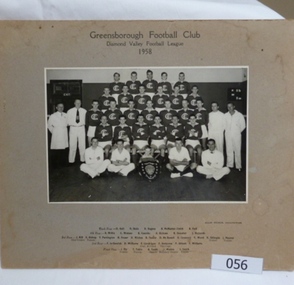
Photograph, Greensborough Football Club 1958, 1958_
A team photograph of the 1958 Australian Rules Football team from the Greensborough Football Club. Includes players and support staff.This photograph is a record of those people involved in the Greensborough Football Club in 1958.Black and White photograph of the Greensborough Football Team 1958. Includes name of players and support team. Mounted on brown card.Greensborough Football Club. Diamond Valley Football League. 1958. Team members: Back row D.Hall R.Skals D.Rogers B.McMaster-Smith R.Hall 4th Row: R.Willis C.Watson B.Coombs R.Dickson R.Danaher J.Richards 3rd Row J.Kill, goal umpire E.Bishop, trainer T.Partington H.Fraser D.Wickes R.Towler D.mcDowell G.Coventry R.Ward K.Gillespie, trainer J.Maurer, trainer 2nd row F.LeGassick D Williams F. Londrigan, capt and coach F.Anderson, vice capt P.Abbott I.Williams Front Row J.Ely, trainer T.Tobin, trainer B. Tooth, mascot J.Waites, boundary umpire, I.Smith, trainer. greensborough football club, 1958 -
 Eltham District Historical Society Inc
Document - Property Binder, 801 Main Road, Eltham
1. Plan: Henry Dendy's Eltham Land 1857-1867: showing Diamond Creek, Bridge Street, Maria Street now Main Road, John Street, Pitt Street, St Margaret's Church 1861, and Eltham Community Centre 1987. 2. Photocopy extract from "Henry Dendy and his emigrants" by L A Schumer, re Portions 12 and 13, Parish of Nillumbik. 3. The President and Councillors of the Shire of Eltham request the pleasure of ____ at the Official Opening of the Eltham Community Centre, Cnr Main Road and Pitt Street, Eltham by the Honorable R.J. Hamer E.D., M.P., Premier of Victoria on Saturday, 22nd April, 1978 at 3.30pm 4. Souvenir Program, Opening of Eltham Community Centre 22 April 1975. 5. Invitation to attend Official Opening of Eltham Community Centre by R J Hamer, Premier of Victoria, 22 April 1975. 6. Flier for Eltham Reception and Conference Centre, photographs of interiors during events. 7. Newspaper article: Eltham buries present for the future, Diamond Valley News 19 November 1985 Eltham, photograph of burying time capsule outside Eltham Community Centre, photograph of Bill Baker and Sid Brown outside old blacksmith shop the original site of Eltham town centre. 8. Letter Peter Butler Shire of Eltham to Eltham District Historical Society, 6 July 1987, detailing process for naming of the halls at the Eltham Community Centre.6 July 1987. 9. Plan of Main Road Eltham - it depicts buildings and occupiers from Pitt Street to Luck Street in the first half of the 20th century. This plan was compiled as a joint efforts by members of the Shire of Eltham Historical Society at a general meeting in Eltham during the 1980s. Newspaper article: Swimming pool and community centre receive major revamps, Diamond Valley Leader, 21 October 2015.main road, eltham, eltham community centre, henry dendy, eltham reception and conference centre, bill baker, sidney brown blacksmith, tme capsule, arthur street, babe taylor house, bakery, boarding house, bradley house, bridge street, brown blacksmith, burgoyne's shop, cockcrofts store, commercial bank of australasia, david lyon house, davis, dr cordner, dr hall, dudley street, eltham hotel, eltham obelisk, eltham war memorial, garnet burges, graham, hawker, henry street, john lyon, len perron, luck street, lyons garage, map, mechanics insitute, monteith house, mrs morris shop, our lady help of christian’s primary school, panther place, pitt street, prior street, shillinglaw cottage, shops, stones mixed shop, websters house, wesleyan methodist church, york street -
 Warrnambool and District Historical Society Inc.
Map - Maps, Soldiers Settlement WW2, Circa 1950
The soldiers' settlement scheme operated after the first and second world wars in an effort to more closely settle the land and also give opportunities to returned soldiers. Crown land and other larger estates were acquired for the purpose. Most of these maps relate to the area north of Warrnambool where many of the subdivisions were parts of larger estates.These maps pertaining to the Soldiers' Settlement program, relate to an interesting part of Australian and local history. As such they have historic and social interest and significance.A collection of 25 paper maps which relate to to the soldiers settlement post World War 2. Some have details of the people allocated the land and some smaller maps have the printed details of the applicants requirements.Text is black on white paper which in some cases is quite aged. The maps are as follows: .1 Narrapumelap Estate ( Ripon & Hampden) .2 Narrapumelap Estate Part 2 (Villers & Ripon) .3 Narrapumelap Estate Part 3 ( Villiers & Ripon) .4 Burrumbeet Estate ( Ripon) .5 ' Berrambool' Estate 9 Hampden & Villiers) .6 ' Hopkins Hill' Estate Villiers 4011 acres .7 Caramut North No 2 Estate ( Villiers ) .8 ' Morpor' Estate ( Villiers) 4172 acres .9 ' Morgiana' Estate ( Normandy) 3453 acres .10 ' Chatsworth House' ( Villiers) 9341 Acres .11 ' East Elwood' Estate Villiers 2407 acres .12 Grey's Estate ( Mornington) 1151acres .13 ' Rowes Estate' ( Buln Buln Gippsland 733 acres .14 'Tarrone' Estate No 2 Part map .15 'Chaldon Meade' Estate (Bourke) Bulla 517 acres .16 ' Terranallum South' Estate Hampden 3757 acres .17 ' Brung Brungle' Estate Dundas 695 .18 ' Armidale ' Estate ( Dundas)2108 acres .19 ' Moyne Falls' Estate ( Villiers) 627 acres .20' Yulong' Estate 9 Lowan 6321 acres .21 Murray Valley Irrigation District 9 Moira)113 acres .22 Murray Valley Irrigation District 103 acres .23 ' Mount Fyans' Estate ( Hampden) .24 ' Barwidgee ' Estate ( Villiers) 4277 acres .25 'Pine Hills' Estate 2nd portion ( Lowan) 6190 acres narrapumelap, berrambool, hopkins hill, caramut north, morpor, chatsworth house, east elwood, terrinallum, moyne falls, tarrone, caramut soldiers settlers, burrumbeet, morgiana, grey's estate mornington, chaldon meade, brung brungle -
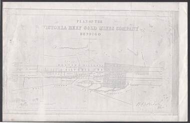 Bendigo Historical Society Inc.
Document - VICTORIA REEF GOLD MINES COMPANY BENDIGO PLAN
Photocopy of a Plan of the Victoria Reef Gold Mines Company, Bendigo. Shaded area is the Victoria Reef Gold Mines Company Lease No. 2 and Lease No. 3. The gullies are named Happy Valley, Long, Derwent, Providence and Ironbark Gullies. The reefs are: Western Victoria, Victoria, Eastern Victoria and Prince Albert Reef. Between the Eastern Victoria Reef and the Prince Albert Reef is the White Lead. Mount Korong Road is at the bottom of the plan. Other Leaseholders are: Burrows, Wybrant, Ballerstedt, Jackson,Roberts & Co, Ashley, Grant, ?rpe, ?eau, Woodward, Coath, Taylor, Cranshaw, Roberts, Gould & Co, Midway, Witscheibe, Endeavour Co, Albert Co, Ballerstedt & Son, Late Iron Bark Quartz Mining Co, McDougall, Specimen Hill Co, Hygrect?, Wheadon, Evans and Bannerman. Signed by H. B. Nicholas. Location of Ballerstedt, Luffsman, Midway Co, Witscheibe and Rae & Co engine locations. Hills are shown as hatch shading. Written at the bottom left ocrner is: Accompanying prospectus issued in Nov. 1859. Signed H.B. Nicholas.plan, bendigo, victoria reef gold mines company, victoria reef gold mines company bendigo - plan, h b nicholas, burrows, wybrant, ballerstedt, jackson, roberts & co, ashley, grant, ?rpe, ?eau, woodward, coath, taylor, cra-shaw, roberts, gou-d & co, midway, witscheibe, endeavour co, albert co, ballerstedt & son, late iron bark quartz mining co, mcdougall, specimen hill co, hyo?, wheadon, evans, bannerman. -
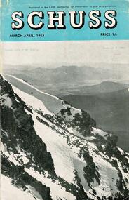 Falls Creek Historical Society
Journal - Schuss Vol. 19. No. 2 March - April 1953
Schuss was advertised as Victoria’s Official Ski Journal It was issued monthly from 1935 to 1961 except during the war when summer issues covered two months. This continued after the war, but it averaged 10 issues annually over its 25 year life. Schuss was published by the Ski Club of Victoria which had a membership of 38 Ski Clubs and demanded to be recognised as the prime authority on skiing in the state. The other 30 ski clubs with 85% of the members disagreed and the politics of skiing became heated. These clubs formed the Federation of Victorian Ski Clubs with their own journal, Ski Horizon. With the establishment of the Victorian Ski Association, Ski-Horizon published its last issue in Nov - Dec. 1955 and the role of the official journal was fully taken over by “Schuss”. This item is significant because it contains stories, images and information documenting the development of the ski industry in Victoria.The journal features stories and events chronicling developments in Victoria and internationally. Items related to the Falls Creek Area in this issue include:- Cover - Features a photo by H.Gibbs titled "Western Cliffs of Mt. Bogong" Page 65 - BOB HYMANS reported news of Falls Creek. At his own Ski School, notable improvements to accommodation have been made and additions to the building itself, which will make it very much more comfortable and serviceable to visitors. Water supply and heating are amongst the items in hand. Bob has acquired a Land Rover which will be a power of assistance to him in maintaining fresh supplies and in servicing his project generally. Kiewa Valley Ski Club members are making splendid progress with the erection of their Lodge. This is the latest building addition in that area and raises the number of clubs resident there to nine. Nissen Ski Tow members intend to operate their tow on the upper slopes of Falls Creek every day during the coming season that conditions permit. They are to be warmly commended on their enterprise. Page 65 - Advertisement for Bob Hymans' Ski School and Lodgeschuss journal, bob hymans, kiewa valley ski club, nissen tow -
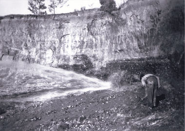 The Beechworth Burke Museum
Photograph, c1920
This photo shows the large mining cavity with a hydraulic sluicing machine in operation at Baarmutha Three Mile Mine, Beechworth . The Beechworth Mining District was one of six mining districts established by the Governor-in-Council on 4 January 1858 under the provisions of An Act for Amending the Laws Relating to the Goldfields (21 Vic no.32). The District was further divided into seven divisions: Spring Creek, Snake Valley, Three Mile Creek, Buckland, Woolshed, Yackandandah and Omeo. The boundaries of each of these divisions and of the whole district are described in the Governor-in-Council's proclamation printed in the Government Gazette, 5 January 1858, pages 3-5. Hydraulic mining is a form of mining that uses high-pressure jets of water to dislodge rock material or move sediment. In the placer mining of gold or tin, the resulting water-sediment slurry is directed through sluice boxes to remove the gold. It is also used in mining kaolin and coal.This photograph shows the impact the gold rush era had on Australia and the earth.A black and white rectangular photograph printed on photographic paperCopied from original on loan film (WEBB QLD) / Donated 2009 NOV/ Baarmutha Three Mile Mine c1920-1950/ Managed by John Weir Peter Jereen Jack Cox / Owned by Plain Bros then Parkinsons Sluicing.mining, gold fields, beechworth, gold rush, burke museum, photograph, mining cavity, hydraulic mining, hydraulic sluicing, baarmutha -
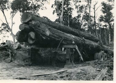
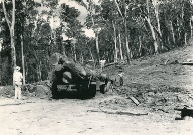 Kiewa Valley Historical Society
Photo - Mountain Creek Logging Camp, 1955
Hume and Hovell discovered the area in 1824 and by the end of the 19th century the valley was transformed by logging, dairy and beef cattle properties and tobacco farms. The logs could have been milled for timber at the State Electricity Commission's mill at Howman's Gap which provided a much needed source of timber for construction of McKay Creek Power Station which began construction in 1951 and also the camps and houses for the workers and their families. There was a need for housing and infrastructure for an increasing population of workers for the hydro-electric scheme as there was a general shortage of this commodity. A timber mill was started in Tawonga by Mates, of Albury, in 1945, and electricity became available in 1946 the S.E.C. bought the mill, and enlarged it. In 1960 it was purchase by a local family, they also started a timber mill in Mt Beauty worked both until 1980 when they closed it. The Tawonga mill and enlarged the mill called Mt. Beauty Timbers Pty Ltd employed approximately 50 people. An historical pictorial record of the general working conditions, type of machinery and vehicles in use in the 1950’s. Note the lack of protective clothing!Black and white photograph of the logging camp at Mountain Creek. November 1955Handwritten on the back of photograph - MOUNTAIN CREEK LOGGING CAMP NOV 55mountain creek logging camp, timber industry, tawonga -
 Kiewa Valley Historical Society
Photo - Logging. Mountain Creek, November 1955, November 1955
Hume and Hovell discovered the area in 1824 and by the end of the 19th century the valley was transformed by logging, dairy and beef cattle properties and tobacco farms. The logs could have been milled for timber at the State Electricity Commission's mill at Howman's Gap which provided a much needed source of timber for construction of McKay Creek Power Station which began construction in 1951 and also the camps and houses for the workers and their families. There was a need for housing and infrastructure for an increasing population of workers for the hydro-electric scheme as there was a general shortage of this commodity. A timber mill was started in Tawonga by Mates, of Albury, in 1945, and electricity became available in 1946 the S.E.C. bought the mill, and enlarged it. In 1960 it was purchase by a local family, they also started a timber mill in Mt Beauty worked both until 1980 when they closed it. The Tawonga mill and enlarged the mill called Mt. Beauty Timbers Pty Ltd employed approximately 50 people An historical pictorial record of the general working conditions, type of machinery and vehicles in use in the 1950’s. Black and white photograph of logging at Mountain Creek November 1955Small typed note attached to the back of photo - Logging Mountain Creek November 1955mountain creek logging camp, tawonga, timber industry -
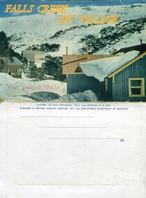 Kiewa Valley Historical Society
Souvenir Postcard Folder – Falls Creek Ski Village
After World War II, the Kiewa Hydroelectric Scheme was started in the Kiewa River valley by the State Electricity Commission of Victoria. On land previously used only for summer cattle grazing in the natural alpine grasslands, the first ski lodge was built in 1948 by workers from the scheme. The first lift, a rope tow, was built in 1951 and the first chairlift in Australia was constructed there in 1957. Falls Creek Post Office opened on 9 June 1958 (with telegraph and telephone facilities only until 1964) .Despite strong opposition from the head of the Kiewa scheme, who didn't want tourists clogging up his roads and destroying his "dry" construction camps by bringing in booze, Falls Creek boomed as much as Hotham, partly owing to its relatively good access road. Early lodges included Bogong (c.1946), Skyline (1947), Albury (1949), Myrtleford (1949) and Dawn (c.1950).The souvenir postcard photographed and produced by an enterprising local businessman Mr S K Pearce, was produced as a memento for skiers and other visitors to the Falls Creek and Mt Beauty area to send to family and friends as a reminder of their visit to the region, or to keep as a personal souvenir. It presented an excellent promotional opportunity for enterprising local businessmen to promote the area to skiers and tourists near and far. It also presents an excellent pictorial history of the falls creek area around the late 1950’s to early 1960’sColour postcard folder (unused) containing 13 photographs of the Falls Creek ski area and surrounds. Inside cover has a brief description of the area and the services available to visitors Printed on front cover- FALLS CREEK SKI VILLAGE. Your Souvenir Folder Photo of skiing slopes of the village Inside front flap - a brief description of the Falls Creek area and the services available to visitors 1. Diana Lodge parking area and Spion Kopje 2. Winterhaven Lodge 3. Ski Hirage Centre and skiing slopes 4. Ski Lodges from main road 5. Nelse and Arundel Lodges 6. Day visitors’ shelter and parking area 7. Summit T-Bar lift 8. Spur T-bar looking towards Village and Spion Kopje 9. T-bar lower station and Snow Crystal Inn 10. ‘Akja’ rescue sled in use 11. Falls Creek road and Grand Coeur Lodge annex 12. Rope tows and beginner slopes 13. Back cover- Published by Nucolorvue Pty Ltd Mentone Vic. Printed in Australia For S.K.Pearce Pty Ltd Tawonga and Mt Beauty falls creek, snow, bogong high plains, victorian alps -
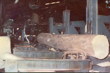 Kiewa Valley Historical Society
Photographs - 2 Colour photographs of logs being harvested and milled for timber in the Kiewa Valley
: Hume and Hovell discovered the area in 1824 and by the end of the 19th century the Kiewa Valley was transformed by logging, dairy and beef cattle properties and tobacco farms. The logs could have been milled for timber at the State Electricity Commission's mill at Howman's Gap which provided a much needed source of timber for construction of McKay Creek Power Station which began construction in 1951 and also the camps and houses for the workers and their families There was a need for housing and infrastructure for an increasing population of workers for the hydro-electric scheme as there was a general shortage of this commodity. A timber mill was started in Tawonga by Mates, of Albury, in 1945, and electricity became available in 1946 the S.E.C. bought the mill, and enlarged it. In 1960 it was purchase by a local family, they also started a timber mill in Mt Beauty worked both until 1980 when they closed the Tawonga mill and enlarged the mill called Mt. Beauty Timbers Pty Ltd which employed approximately 50 people. An historical pictorial record of the type of machinery and vehicles in use in the 1950’s to harvest and mill the logs from surrounding forested areas.1. Colour photograph of large logs being milled for timber at a timber mill 2. Colour photograph of heavy machinery being used to harvest large logs for milling timber; timber mill; kiewa valley; forests; logging -
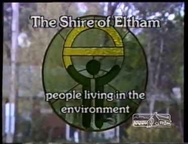 Eltham District Historical Society Inc
Film - Video (VHS), IMP Productions, Eltham Shire Council - People Living in the Environment (Series 69, Item 2), 7 Oct 1985
Shire of Eltham Archives: Series 69, Item 2 This video was produced for the Shire of Eltham in response to the 1985 Victorian Local Government Commission Report titled ‘The Restructure of Local Government in Victoria – Principles and Program’ (the Morris review). The recommendation was to amalgamate the Shires of Eltham and Diamond Valley, something that Eltham Council did not support as being appropriate for the shire or compatible with the 'Spirit of Eltham'. The video features Shire President, Cr. Mary Grant talking with the Hon. Pauline Toner MP and Max McDonald MP. Eltham Shire CEO Rodney Roschellor presents an alternate proposal for a shire merging more aligned to the 'Spirit of Eltham'.Also featured are Eltham icons such as the Eltham Railway Trestle Bridge, Montsalvat, Eltham Community Centre along with mudbrick making, artist Matcham Skipper, the Green Wedge and St Andrews Market. Other commentary is provided by locals Judy Wadham and Lester Eaton.VHS Video cassette Converted to MP4 file format 00:10:56; 73MBcouncil amalgamation, cr. mary grant, eltham community centre, eltham railway trestle bridge, eltham shire council, green wedge, judy wadham, lester eaton, matcham skipper, max mcdonald, montsalvat, morris review, mudbrick construction, pauline toner, rodney roscholler, shire of diamond valley, shire of eltham, spirit of eltham, st andrews market, video recording, shire of eltham archives -
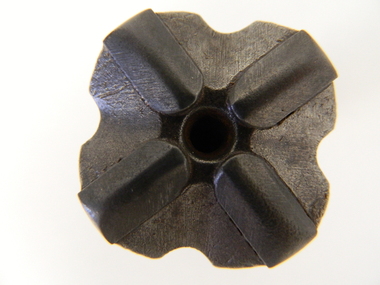 Kiewa Valley Historical Society
Drill Bit, Circa 1950
This is the cutting bit on the end of a drilling rod. It would have been used to drill holes into rock for placing explosives, for installing steel rock anchors, etc. In hard rock the bits need to be replaced regularly. Compressed air is blown through the holes near the tip of the bit to blow rock fragments out of the drill hole. The main drilling unit would have been powered by compressed air (Pneumatic). Rotary Air Blast Drilling. This drill bit was used by workers in the SEC Vic. Kiewa Hydro Electricity Scheme. This type of bit although strong needed replacing frequently when the rock composition (type of rock) was extremely compact. The configuration of the tip bit (four star like pattern) was to provide the "teeth" to tear into the rock. This bit was manufactured in 1949 however drilling for rock cores, in the Kiewa Valley and the Victorian Alps, was carried out from the late 1920's.This particular drill bit would have been used by construction workers to drill holes into rock for either explosives or for installing steel anchor points into the rock. The use of compressed air was not only for waste extraction but also for running the main drilling unit.This four star rotary air balst (RAB) drill bit has a central "blow" hole (compressed air outlet to remove the ground rock particles through four extraction holes). There are four raised cutting/grinding lugs which allows the air compression hole(incoming) to always have a clear unblock opening. Extracted ground material is "blown" out from the drill head via the larger hole created by the steel bit.Stamped on the bottom outside shank "FAGERSTA SECO SWEDEN" and below this "102 7041 01 05 049".sec vic kiewa hydro scheme, alternate energy supplies, drilling into rocks in alpine regions -
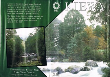 Kiewa Valley Historical Society
VHS Tape - Kiewa Hydro Electricity Scheme x2, Kiewa, Circa 1990
This VHS was produced by the State Electricity Commission of Victoria, to show the pristine state of the Kiewa River and Valley post the completion of the Kiewa Hydro Electricity Scheme (Circa 1950s), The late 1970s on wards was the beginning of deeper social scrutineering by pro environmental groups such as the Australian Wilderness Society (1976) and the Greens (political Party), before, during and after the construction phases of any man made structures in forest/bush areas which may or could damage or adversely affect the natural flora and fauna of sites. This promotional VHS, which was produced in the 1990s, was to project that unlike the Tasmanian State Electricity Commission (Franklin Dam issue), the Victorian State Electricity Commission acted in a way to protect the environment to the maximum level possible. With the passage of time since, and the issue of the global push to minimise carbon pollution, and as an alternative to coal fired power stations, the use of hydro electricity can now be seen as a highly efficient alternative to "coal powered" electricity. This VHS is a snap shot in time (1990) when the Kiewa Valley was still relatively under populated and holiday houses owned by city bound workers was still relatively insignificant. As more and more holiday makers retire to a small but friendly region(Kiewa Valley and Mount Beauty) the increase in visitor numbers will affect the local rural bush scene more and more. The changes that will occur (in time) can be measured against the scenes presented in this video. The additional resources provided by the State Electricity Commission of Victoria of "alpine bush" fire control and management, together with an ongoing educational scheme for school children in learning about what constitutes the Alpine country's unique environment, are a very important offshoot, benefitting to both the communities within the Kiewa Valley and regional Victoria.This VHS tape is stored within its own plastic cover which has a front side covered by a coloured photograph(both front and back cover) of the Kiewa River, just to the north east of the Mount Beauty township. The VHS tape is nestled within a formed inner structure which not only prevents the tape from moving to and fro but also unnecessary intrusion of foreign particles.Front cover "KIEWA" on the spine top circle with lines projecting out and below this "SEC". Middle of spine "KIEWA" and bottom of spine "VHS"secv, kiewa valley, dale-bromley, cy-duff, chris- harding, michael-glucz, forestation education, wilderness photography, nature film. -
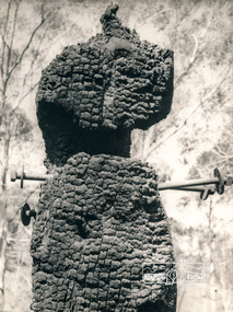 Eltham District Historical Society Inc
Photograph, George W. Bell, Diamond Creek, 1969, 1969
Canberra Times (ACT : 1926 - 1995), Thursday 9 January 1969, page 1 A day of century heat, 13 KILLED IN VICTORIAN FIRES ...About thirty houses and a public hall were destroyed by fire in the township of Diamond Creek. The group officer of the Diamond Creek Fire Brigade, Mr Tom Harrington, said tonight that he thought it was a "miracle" that no-one lost their lives in the fires. A relief centre for the homeless was set up by the Diamond Valley Shire Council. Mr Harrington said that the first fire call in the town was received at 10.45 am. "Within 20 minutes there were five more fires and it seemed like the whole town was alight", he said. "It was a chaotic day. All our best plans for fighting the fires became disorganised. "As 60-mile-an-hour winds swept fires through different parts of the town many fire fighters were unable to get from one fire to another. ," Black and white photograph of charred fire remnant Diamond Creek 1969diamond creek, fire, george w bell collection, bushfire, charred, burnt timber -
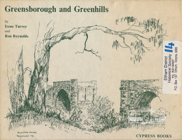 Eltham District Historical Society Inc
Book, Irene Turvey et al, Greensborough and Greenhills / words by Irene Turvey ; Drawings by Ron Reynolds, 1973
Pen and ink sketches accompanied by appropriate text in double page spreads. Contents cover : Blue stone bridge, Introduction, House cnr Church and Hailes Street, House - 25 Hailes Street, Yandell Reserve, Greensborough Hotel, Lobb's Kiosk, House - 49 Grimshaw Street, View of Greensborough (from Delphin Crescent), Railway Station, Old Barn (near Greensborough Railway Station), Partington's Flat and River Valley, Rand Street Bridge, Lower Main Street, Greenbriar Nursery, Hitching rail, Ashmead - Dr Cordner's Home, Greensborough Primary School, House - cnr St Helena and Diamond Creek Raods, Sondermeyer's Hill, Methodist Church, Football Pavilion, Cemetery, St Katherine's Church, St. Helena, Civic Centre, Briar Hill Timber Mill, 24 River Street, Kelly's Garden Supplies, 158 Main Street, Old Swimming pool, 105 Main Street.Hardback; 62 p. : ill., map ; 19 x 25 cm.ISBN 0909807108 Signed by author and illustrator Two copiesgreenhills, greensborough -
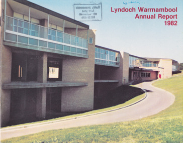 Warrnambool and District Historical Society Inc.
Document - Lyndoch Warrnambool 1982 Annual Report
This is the 1982 Annual Report for Lyndoch Home and Hospital for the Aged, Warrnambool. It contains lists of Board Members, a President’s Report, Lyndoch’s Aims, financial reports, photographs and a list of Life Governors. Lyndoch Home for the Aged was established in 1952 and has developed with a wide range of facilities for the aged since that date. The original Lyndoch property near the mouth of the Hopkins River was owned by a Melbourne tea merchant, George Rolfe, who bought the land when there were on the site only a couple of cottages and a larger building which had been a school, Warrnambool Grammar, run by Henry Kemmis. Rolfe acquired the land in the 1870s and named the property Lyndoch after the town in the Barossa Valley where he had lived. He owned Lyndoch for 44 years and it was his stepdaughter, Florence Lake who built in the 1920s the bungalow known as Lyndoch which forms the original building of the Lyndoch Home for the Aged, Today the facility is called Lyndoch Living. This 1982 report is kept for the benefit of researchers wanting details of the history of Lyndoch over the past 30 or 40 years. This is a booklet with a plasticized cover with a white back and a multi-coloured front cover. The front cover has a photograph of a Lyndoch building. There are six double-sided pages with printed material and photographs on white paper and a yellow and orange strip across the top of the pages. The pages are stapled.On front cover: Lyndoch Warrnambool Annual Report 1982 Stamp of Warrnambool Library On back cover: A red circle with the words ‘Lyndoch, Comfort and Security for Aged Folk’ lyndoch aged care facility, warrnambool, lyndoch warrnambool -
 8th/13th Victorian Mounted Rifles Regimental Collection
Document - History Tocumwal Troop
The Tocumwal Troop was the most northerly sub-unit of the 20th Light Horse regiment. It was a highly successful troop in inter-troop competition and also provided the mounted escort to the new Governor of Victoria, Sir Winston Dugan, in July 1939. The 20th Light Horse (Victorian Mounted Rifles) was raised in 1920 as part of the 3rd Cavalry Brigade, 2nd Cavalry Division, Citizen Military Forces, with Headquarters at Seymour and depots along the Goulburn Valley from Mansfield to Tocumwal in southern NSW. In December 1941, 20th Light Horse (Victorian Mounted Rifles) converted from horse to mechanised, initially as 20th Motor Regiment. In 1943 the Regiment was deployed to Merauke, Dutch New Guinea. Upon its return in April 1945, the Regiment was redesignated 20th Pioneer Battalion. It was disbanded following the end of the war. 20th Light Horse was the only light horse regiment to serve overseas in WWII.Photocopy of a typed document, three pages, relating to Tocumwal Troop 20th Light Horse Regiment.tocumwal, 20th, light horse -
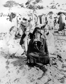 Surrey Hills Historical Society Collection
Photograph, Stalker family beach picnic, 1930s
Associated with the Stalker family of Surrey Hills. Betty Neil Smith (Stalker) was born in 1919 in Balwyn (Surrey Hills). She was one of 4 daughters of Alexander MacLaren Stalker (1885-1970/1973) and Charlotte Eleanor Hayward (1884-1953) who were married in 1911. Her sisters were Ruth McLaren Stalker (1913, Surrey Hills), Joan Winnock Stalker (1917, Surrey Hills) and Beatrice Mary Stalker(1919). Their mother Charlotte Hayward was a teacher prior to her marriage. Their father Alexander, an accountant, lived in Wattle Valley Road, Canterbury in 1910. From 1912-1931 they are listed at ‘Benwerrin’, (44) Wandsworth Road, Surrey Hills. This was later the home of Beatrice Mary and Howard Everard. Betty, Ruth and Joan later lived at 9/48 Wandsworth Road. it is assumed that the photo is of the Stalker girls and given their parents' later residence at Brighton, this may have been taken at Brighton beach. This photo documents part of the social history of a family with a long and strong association with Surrey Hills. The backdrop of the typical bathing boxes used for changing into swimsuits, for lunch and for storing sports and beach gear, documents beach recreation and culture of the 1930s. For many years in the late nineteenth century, Brighton was Melbourne's favourite seaside destination. The now iconic bathing boxes were a response to Victorian ideas of morality and sea bathing. There are 82 Brighton bathing boxes, which protected by a heritage overlay because of their uniform scale and proportion, building materials, sentry order alignment. All retain their classic Victorian architectural features with timber framing, weatherboards and corrugated iron roofs. They remain as they did over one hundred years ago, as licensed bathing boxes. Service amenities such as electricity or water were never connected.A black and white photograph of many people enjoying the beach. There are bathing boxes in the background and some ti-tree beyond that.uniforms, clothing and dress, bathing boxes, stalker family