Showing 10386 items
matching plan
-
 City of Kingston
Pamphlet - Colour, T. H. Ould Publishing Co, The Ridge Estate, Cheltenham, c. 1930
Sales plan for land in the suburb of Cheltenham, bounded by Johnston Street, Silver Street and Cavanagh Street, incorporating lots on either side of Sunray Avenue.The developing urban area of Cheltenham within the City of Kingston. This land sale pamphlet illustrates the subdivision of land within the municipality and the changing demographic of the district as new houses are constructed close to infrastructure.Colour pamphlet advertising for sale lots in The Ridge Entrance Estate, Cheltenham. Incorporates a map of the estate bordered by Johnston Street, Silver Street and Cavanagh Street, including subdivision lots on either side of Sunray Avenueland sales, estate, cheltenham -
 City of Kingston
Pamphlet - Colour, Stillwell and Co, The Hill Estate, Highett, 1917
Sales plan for land in the suburb of Highett, bounded by Point Nepean Road and including Sandford Street, Turner Road, Alfred Street and Peace Street.The developing urban area of Highett within the City of Kingston. This land sale pamphlet illustrates the subdivision of land within the municipality and the changing demographic of the district as new houses are constructed close to infrastructure.Colour pamphlet advertising for sale at auction The Hill Estate, Highett. Incorporates a map of the estate bordered by Point Nepean Road and including Sandford Street, Turner Road, Alfred Street and Peace Street.Handwritten in grey pencil on subdivision map next to subdivisions 91, 92, 93, 106, 107 and 108: x Handwritten in grey pencil on back cover: The / Hill Estate / Highettland sales, estate, highett -
 Melbourne Tram Museum
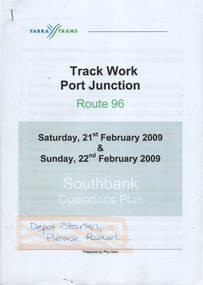
Document - Operations Plan, Yarra Trams, "Track Work Port Junction - Route 96", Feb. 2009
Document prepared for Yarra Trams staff to provide an operations plan for the reconstruction of Port Junction, route 96, Feb. 2009. Has a table of contents. Demonstrates a Yarra Trams operations plan.Document - 35 pages, full colour stapled in top left hand corner.tramways, route 96, port junction, trackwork -
 Tatura Irrigation & Wartime Camps Museum
Photograph, Dhurringile Escape, 2001
Dhurringile Escape through Tunnel. Detmers; Bertram; Grotz; Jas; Kernstock; Folter; Jung; Plattfaut; Jansen; Menge; Kissel; Raasch; Eberle; Somann; Mader; Blomberg; Koch; Sommer; Rodszies; Schmidt. 2 Articles. Further references in folders: 1829- sketch of camp 13 tunnel.|800- Plan of Dhurringile with room allocation of POW's 858- Army Garrison. 1762- Intelligence Reports. Newspaper articles in top drawer of plan cabinet.detmers, bertram, grotz, jas, kernstock, folter, plattfaut, jansen, menge, kissel, raasch, eberle, somann, mader, blomberg, koch, sommer, rodszies, schmidt, room allocation -
 Ringwood and District Historical Society
Photographs, Suda and Khassa Ave Ringwood, Before and after Ringwood Bypass Construction 1993
B&W photograph taken by Ringwood Historical Research Group. Also added extract from Melways showing the roads before the Bypass (1987) showing the planned Bypass cutting these two roads, and Melways (2018) showing new alignment with Bypass11063A: 17.1.93 Suda Ave Still intact towards Maroondah Hwy. Taken near Khassa Pde 11063B: 17.1.93 Suda Ave. House gone. Near Khassa Pde 11063C: 17.1.93 Ringwood Bypass from cnr Khassa Pde and Suda Ave towards Mt Dandenong Rd 11063D: 17.2.93 Suda Ave. House gone. 11063E: 21.2.93 cnr Khassa Pde and Suda Ave. Direction of next cut for the Ringwood Bypass. Trees to go. 11063F: 21.2.93 Connection from ??? St to North end of Suda Ave 11063G: 22.2.93 Adelaide St to right (closed). Mile Ave in front and turning left. Note the grey wall along Miles St to support the new car park development. Shrub on left is in the bowling club. -
 Ringwood and District Historical Society
Photographs, Eastland Car park Construction, Ringwood, 1992-93
B&W photograph taken by Ringwood Historical Research Group. Also added extract from Melways showing the roads before the Bypass (1987) showing the planned Bypass cutting these two roads, and Melways (2018) showing new alignment with Bypass11064A: 21.2.92 Eastland car park development from near Safeway 11064B: 21.2.92 Eastland car park development from Adelaide St 11064C: 4.1.93 Eastland car park development from Warrandyte Road from Op. Bond St. 11064D: 4.1.93 New Myer Eastland car park viewed from Safeway's Roof 11064E: 17.1.93 Eastland car park near where Esso Garage was 11064F: 21.2.92 Eastland car park from cnr of Adelaide St and Eastland -
Federation University Historical Collection
Booklet, Ballarat School of Mines Discussion Paper for a meeting with Hon. J.L. Simmonds, MP, 1985, 1985
Soft page booklet Ballarat prepared for a meeting with J.L. Simmonds, M.P. - Minister of Employment and Training and Representatives of Major Local Industries. Topics include corporate goal, priorities, I.S.O. COde of Practice, planned capital expenditure, programs and new initiatives. ballarat school of mines, smb campus, lydiard street, capital works, j.l. simmonds, lydiard st campus, corbould hall, motor mechanics, ballarat junior technical school building refurbishment, horticulture complex, grant st pedestrian overpass, court house refurbishment -
 Ringwood and District Historical Society
Newspaper, The Mail, June Antonoff on her father's life, Henry Ernest Parker
Obituary from The Ringwood Mail of Henry Ernest Parker by Anne Mulvaney, Ringwood Mail 27 February 1991. He was former Ringwood councillor and Mayor. June Antonoff, daughter, talked about him, especially about planning of Ringwood and gardens. -
 Bendigo Historical Society Inc.
Document - LA TROBE UNIVERSITY BENDIGO COLLECTION: THE PRESENTATION OF HISTORY 4
A brown folder titled "The Presentation of History 4". A teaching plan with which to teach the curriculum subject history. From the files of Mr. L.J. Pryor. Former Principal of Bendigo Teachers' College. Donated to Education Resource Centre for archival use 1992.bendigo, education, bendigo teachers' college, la trobe university bendigo collection, collection, bendigo, education, history, history - study and teaching, teaching, curriculum, stdents, mr. l.j. pryor, male, individual, person, education, resource centre -
 Bendigo Historical Society Inc.
Document - LA TROBE UNIVERSITY BENDIGO COLLECTION: THE HISTORY CURRICULUM 3
A brown folder titled "The History Curriculum 3". A teaching plan with which to teach the currculum subject history. From the files of Mr. L.J. Pryor. Former Principal of Bendigo Teachers' College. Donated to Education Resource Centre for archival use in 1992.bendigo, education, bendigo teachers' college, la trobe university bendigo collection, collection, bendigo teachers' college, bendigo, education, teaching, history, history - study and teaching, curriculum, mr. l.j. pryor, male, person, individual, education resource centre -
Bendigo Historical Society Inc.
Map - CAMPBELL COLLECTION: BENDIGO AND DISTRICT MAPS, 11-4-29
Map. Huntly, Parishes of Huntly Nerring and Neilborough. Scale 20 chains to 1 inch. Total area 4738 acres. Eaglehawk. Prepared in W.J.B. from A. and C.L. Plans by W.J.Galbraith 11-4-29. (number 396 in map cupboard 1)W.J.Galbraithmap, bendigo, agricultural lands -
Bendigo Historical Society Inc.
Map - CAMPBELL COLLECTION: BENDIGO AND DISTRICT MAPS, 14-6-29
Map. Terricks, Parish of Terrick Terrick West, scale 20 chains to 1 inch, total area 6318 acres, prepared in W.P.B. from Assessment and Parish Plans by W.J.G. 14-6-29. (number 388 in map cupboard 1)W.J.Galbraithmap, bendigo, agricultural lands -
Bendigo Historical Society Inc.
Document - VICTORIA HILL - WORK STAGES FOR THE CENTRAL NELL GWYNNE AND VICTORIA HILL
Two typed copies (a & b) of restoration plans for the Central Nell Gwynne and Victoria Hill areas.Notes list first and second stages for the work to be carried out. Notes dated ''about May 1968''. New Chum Hill Area is also mentioned.document, gold, victoria hill, victoria hill, work stages for the central nell gwynne, victoria hill and new chum hill areas, city council, historical society bendigo branch, caleb thomas 1879, b c v 8, lazarus old chum, new chum and victoria, p m g repeater station -
Bendigo Historical Society Inc.
Photograph - FORTUNA COLLECTION: PLAN DRAWING FORTUNA VILLA
Plan of Fortuna villa entrance and garden elevations copied onto acetate material ( copies of original drawings). Written on top 'Fortuna Villa, G. Lansell Esq. Scale 8 feet to one inch.' Possibly originals drawn by W. Beebe.bendigo, house, fortuna villa -
Bendigo Historical Society Inc.
Document - NEW CHUM LINE OF REEF - REFERENCE TO CALEB THOMAS PLANS
Five pages of reference numbers used on Caleb Thomas plans. Has the mine's name, size of shaft and on other pages, the height of the sill. One mine on the Sheepshead Line, the New St Mungo is mentioned. Many mines along the reef are mentioned.document, gold, mines, new chum line of reef, reference to caleb thomas plans, catherine reef extd., new franklin, murchison, catherine reef united, catherine reef (south), williams (new), acadia catherine, william's united, york & durham, belmont & saxby, ellenborough, sadowa, (old) st mungo, lady barkly, princess alice (sth st mungo), unicorn trib, pheonix, hopewell, united devonshire (princess alex), west united devonshire, east united devonshire, duchess of edinburgh, south devonshire, duchess tribute, new st mungo, new st mungo, new vict catherine, gt extd vict, herc new chum (late pearl), pearl south, north herc & energetic, herc & energetic, ironbark, vict consols, south new chum, lansell's 616, south belle vue, eureka extd, new chum rly, south old chum, new chum consolidated, ellesmere (south shaft), garibaldi, cravens, young chum, ellesmere nth shaft, new chum united, new chum vic, old chum, lazarus, cent new chum, lansell's 222, north old chum, lansell's big 180, advents advance, gt cent vict, hamboldt, ballerstedt, victoria quartz, herc & energetic, herc (old), shenandoah, victoria reef gold, victoria consols -
Port Melbourne Historical & Preservation Society
Audio - Radio 3LO program excerpts, Sandridge City Development plan, 1991 - 1993
Various excerpts from 3LO radio prgrams, including Ranald McDONALD interviewing Jim KENNAN and Doug AITKEN interviewing Mark BIRRELL about Sandridge City Development (Bayside Plan) Recording duration 47:09. Approx 1991 and 1993town planning - proposals shelved - bayside, jim kennan, mark birrell, sandridge city development co pty ltd, scdc -
 Bendigo Historical Society Inc.
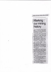
Document - LONG GULLY HISTORY GROUP COLLECTION: MARKING OUR MINING HISTORY
Copy of a newspaper article titled Marking our mining history printed in the Bendigo Adveretiser 27/5/2002. the Long Gully History Group plans to create an information marker in its neighbourhood acknowledging the role underground mining made to Bendigo.bendigo, history, long gully history group, the long gully history group - marking our mining history, long gully history group, the bendigo cornish association, george ellis, bendigo advertiser -
Whitehorse Historical Society Inc.
Document, Municipal Chambers, Nunawading, 23/07/2001 12:00:00 AM
Papers relating to applications for Council permits, objections and VCAT hearingsPapers relating to applications for Council permits, objections and VCAT hearings concerning development of 360-362 Whitehorse Road, Nunawading, and of 13 Walkers Road, Nunawading. Includes maps, plans, photos and architectural assessment of 360 Whitehorse Road by Andrew Ward.Papers relating to applications for Council permits, objections and VCAT hearings associated planning consultants, arrowsmith, valda, nunawading and district historical society, municipal chambers, whitehorse road, nunawading, no 360, no 362, walkers road, no. 13, victorian civil and administrative tribunal, ward, andrew, city of whitehorse -
Whitehorse Historical Society Inc.
Document, Civic Centre Amphitheatre Floor, 1995
Program, plan, publicity and other documents relating to the City of Whitehorse Civic Centre Amphitheatre Floor Ceramic Tile Project.Program, plan, publicity and other documents relating to the City of Whitehorse Civic Centre Amphitheatre Floor Ceramic Tile Project. Nineteen schools worked on the project, under the auspices of the Nunawading Schools Community Arts Project. Photos at NP 3606-3624Program, plan, publicity and other documents relating to the City of Whitehorse Civic Centre Amphitheatre Floor Ceramic Tile Project.nunawading schools community arts project, city of nunawading, tiles -
 Whitehorse Historical Society Inc.
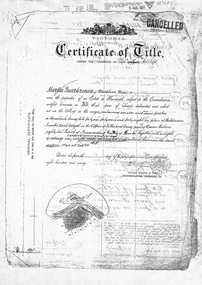
Document, Gordon Crescent, 4/09/1890
Photocopy of Certificate of Title Vol. 2296 Fol 45903S, being part of Lots 46, 47 and 48, Plan of Subdivision No 2400, part Crown Portion 82 to Martha Quarterman 4 September 1890, transferred to Finlay Urquhart 5March 1946.gordon crescent, blackburn, central road, quarterman, martha, urquhart, finlay, land subdivision -
 Whitehorse Historical Society Inc.
Photograph, Nunawading Primary Schools Community Art Project -2004-5, 1/06/2005 12:00:00 AM
See ND5890One of a set of 19 coloured photographs relating to the Ceramic Tile Project by the Nunawading Primary Schools Community Art Project which was installed in the Amphitheatre at the rear of the Nunawading Civic Centre. This Photo is a general View. Text, Plans & Publicity - see ND5890nunawading primary schools community art project., city of whitehorse. civic centre, ceramic tile project, civic centre -
Lakes Entrance Regional Historical Society (operating as Lakes Entrance History Centre & Museum)
Photograph
Black and white photograph showing Barry Secombe and Michael Ellis of Tambo Shire with Pat McNamara National Party State Leader during presentation of plans for new project taken at Tambo Shire Office Palmer Road Lakes Entrance Victoriacelebrations, local government -
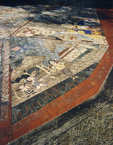
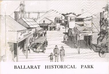 Bendigo Historical Society Inc.
Book - MERLE HALL COLLECTION: BOOKLET: ''BALLARAT HISTORICAL PARK''
Booklet: ''Ballarat Historical Park'' B&W illustrated booklet (''A Presentation of the Project of the Ballarat Historical Park Association'' re Sovereign Hill. - formation of the Association; story of Sovereign Hill; the site and the plan; potential as a tourist centre; committee and consultants listed. -
University of Melbourne, Burnley Campus Archives
Book, Market Garden, 1956
No. 01310H Norman Bros. Pty. ltd. 60-62 Elizabeth St., Melbourneorchard, field station, vegetables, cropping, market garden, nutrients -
Canterbury History Group
Ephemera - An opportunity awaits, 77 Highfield Road Canterbury, 2007
Real estate brochure for the sale of 77 Highfield Road Canterbury by auction on 7 July 2007. Includes a coloured photograph of the exterior and floor and site plan. Also a note by Robin Kelly that the property was sold for $1.3 million (September 2007) to be demolished.canterbury, highfield road, edwardian style -
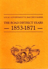 Bacchus Marsh & District Historical Society
Book, John Lloyd, The Road District Years, 1853-1871: Local Government in Bacchus Marsh
This work describes the early evolution and history of local government in the Bacchus Marsh area. Local government bodies in Victoria and in other places had their origins in committees and local boards which were established to regulate over pressing local issues, raise revenue, and expend it in a limited range of social and economic ways. The early areas of responsibility were dominated by the need for local roads and this book primarily looks at this period of local government history in the Bacchus Marsh area. Overtime the range of areas local government bodies took responsibility for expanded and this work begins to trace this transformation in its earliest stages. It is a fascinating and detailed account of the early history of local government in Bacchus Marsh containing many amusing anecdotes among the wealth of administrative historical data. The author who was at one time an employee of the Shire of Bacchus Marsh has drawn directly from the early local records such as minutes of meetings, records of expenditure, newspaper reports and notices in the Victoria Government Gazette.Soft cover foolscap size book. 128 pages with b & w illustrations, maps and plans. No publisher is indicated in the work but it is likely to have been privately published by the author John Lloyd. Year and place of publication is 1986, Bacchus Marsh, Victoria.non-fictionThis work describes the early evolution and history of local government in the Bacchus Marsh area. Local government bodies in Victoria and in other places had their origins in committees and local boards which were established to regulate over pressing local issues, raise revenue, and expend it in a limited range of social and economic ways. The early areas of responsibility were dominated by the need for local roads and this book primarily looks at this period of local government history in the Bacchus Marsh area. Overtime the range of areas local government bodies took responsibility for expanded and this work begins to trace this transformation in its earliest stages. It is a fascinating and detailed account of the early history of local government in Bacchus Marsh containing many amusing anecdotes among the wealth of administrative historical data. The author who was at one time an employee of the Shire of Bacchus Marsh has drawn directly from the early local records such as minutes of meetings, records of expenditure, newspaper reports and notices in the Victoria Government Gazette.bacchus marsh shire council, local government bacchus marsh history -
 Tarnagulla History Archive
Telegram: Bagge to Inspector General of Public Works, 14th October, 1863
Murray Comrie Collection. A telegram sent from a C.H.O. Bagge in Tarnagulla to the Inspector General of Public Works in Melbourne on October 14th, 1863. Concerns checking of water levels in Inglewood and Tarnagulla Reservoirs, cost to build water races and planned travels to Dunolly and St. Arnaud.tarnagulla, post office, telegrams, bagge, water, resources, inspector general of public works, infrastructure, correspondence, communication, government -
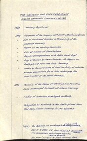 Melbourne Tram Museum
Document - Research Notes, H. S. McComb, "The Oakleigh and Ferntree Gully Steam Tramway Company Limited", 1960's?
Handwritten timeline on foolscap paper, titled "The Oakleigh and Ferntree Gully Steam Tramway Company Limited", giving years and events and reference documents with reference on the second page to a sketch plan from various documents. Dates 1888 to 1890. Map not with document.trams, tramways, steam trams, oakleigh, ferntree gully -
Melbourne Tram Museum
Newspaper, The Age, “City blocked: time to walk the walk”, 16/05/2019 12:00:00 AM
Newspaper clippings titled: “City blocked: time to walk the walk” Newspaper clipping from the Age 16/5/2019 by Jewel Topsfield Melbourne City Council considers plan to transform Elizabeth St into a more pedestrian and cyclist friendly precinct.trams, tramways, planning, melbourne, tram routes, elizabeth st -
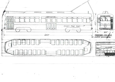 Melbourne Tram Museum
Drawing, Melbourne & Metropolitan Tramways Board (MMTB), "Proposed Box Car", Jan. 1955
Print of drawing R9495, "Proposed Box Car" - with one end and one large central door, high floor - streamliner US PCC approach. Gives side elevation and floor plan. Seats 52 passengers. Prepared 10/1/1955trams, tramways, pcc class, bogie trams, new tramcars, tramcar construction, proposals