Showing 10832 items
matching maps
-
 Bendigo Historical Society Inc.
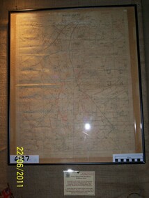
Map - HUNTLY : COUNTY OF BENDIGO, August 1954
Map. Huntly, County of Bendigo. Whirrakee, Bagshot, Wellsford, Nerring, Neilborough, Township of Huntly. Drawn and reproduced at the Department of Lands and Survey, Melbourne, Victoria. August 1954. Price 2/-. By authority W.M. Houston, Government Printer. (number 42 in map cupboard 1)W.M. Houston, Govt. Printer.map, bendigo, huntly -
Bendigo Historical Society Inc.
Map - TALAMBE : COUNTY OF BENDIGO, 17-12-15
Map. Talambe, County of Bendigo, Hayanmi, Dingee, Tandarra, Yallook, Pompapiel. Photographed at the Department of Lands and Survey, Melbourne by W.J. Butson,17-12-15, Price 1/-. Albert J. Mullett, Govt. Printer, Melbourne. (number 17 in map cupboard 1)Albert J. Mullett, Government Printer, Melbourne.map, bendigo, talambe -
Bendigo Historical Society Inc.
Map - YARRABERB : COUNTY OF BENDIGO, 2-3-51
Map. Yarraberb, County of Bendigo, Salisbury, Yallook, Neilborough, Nerring, Leichardt, Bridgewater. L5373. By authority H.J. Green, Govt. Printer,Photo-Lithographed at the Deptartment of Lands and Survey, Melbourne. Price 2/-.2-3-51. (number 15 in map cupboard 1)H.J. Green, Govt. Printermap, bendigo, agricultural lands -
Bendigo Historical Society Inc.
Map - PANNOOBAMAWM : COUNTY OF BENDIGO, 1957
Map. Pannoobamawm, County of Bendigo. By Appointment W.M. Houston, Government Printer, Melbourne. Drawn and reproduced at the Department of Lands and Survey, Melbourne. Price 2/-.1957. Turrumberry, Terrick Terrick East, Wanurp,Pannoomilloo, Bamawm, Pannoobamawm. (number 2 in map cupboard 1)W.M. Houston, Government Printermap, bendigo, pannoobamawm -
Bendigo Historical Society Inc.
Map - NOLAN, COUNTY OF BENDOGO, 7-5-30
Map, Nolan, County of Bendigo, Egerton; Elmore; Goornong. Campaspe River, Elmore Estate, By Authority: H.J.Green, Government Printer,Melbourne.Price 2/-.Drawn and Reproduced at the Dept. of Lands and Survey,Melbourne,Victoria.7-5-30. (number 1 in map cupboard 1)H.J.Green,Government Printermap, bendigo, nolan -
Bendigo Historical Society Inc.
Map - NERRING : COUNTY OF BENDIGO, August 1952
Map. Nerring, County Of Bendigo. Yarraberb, Neilborough, Huntly, Sandhurst, Leichardt, Marong. Drawn and reproduced at the Department of Lands and Survey, Melbourne,Victoria. August 1952, Price 2/-. By Appointment J.J. Gourley, Government Printer, Melbourne. (number 0 in map cupboard 1)J.J. Gourley,Government Printermap, bendigo, nerring -
Bendigo Historical Society Inc.
Map - BENDIGO BUS ROUTES, 1934 - 1958 ?
Map: Bendigo bus Routes, State Electricity Commission of Victoria, Electricity Supply Department. Printed on the bottom right hand corner F.E.B 23-12-47 , R.L.A. 5-9-58, 19-9-34, 27-11-37. 4 Mapsmap, bendigo, transport, state electricity commission, bendigo bus routes -
 Bendigo Historical Society Inc.
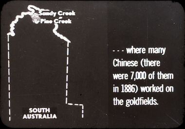
Slide - DIGGERS & MINING. THE CHINESE ON THE GOLD FIELDS, c1850s
Diggers & Mining. The Chinese on the Gold Fields. Slide: Shows map of South Australia, Sandy Creek and Pine Creek are at the top of the map. Slide; reads . . . Where many Chinese (there were 7,000 of them in 1886) worked on the goldfields. Markings: 3. Used as a teaching aid.hanimounteducation, tertiary, goldfields -
 Bendigo Historical Society Inc.
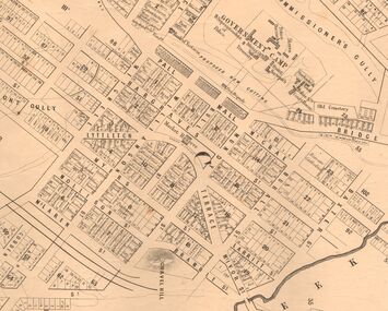
Map - MARKS COLLECTION: MAP SANDHURST 1867
Original map: Sandhurst 1867, shows central Bendigo and surrounds, including police camp, stockade, 'old cemetery', reserve for. On bottom of map: 'Lithographed at the Department of Lands and Survey by D. Henderson, 20 February, 1867'. On top RH corner 'Sheet No 1 Sandhurst'.map, bendigo, 1867 sandhurst map -
 Melbourne Tram Museum
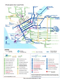
Map, VicTrip, Melbourne tram network - Yarra and M>Tram, 2000
Map - Colour print - of Melbourne's tram network, shows the lines operated by M>Tram or Yarra Trams, route numbers, ticket zones, zone overlaps and contact websites. - used in Fares and Travel Guide - 2000 and 2001 Map - see Reg Item 2508.trams, tramways, connex, map, melbourne, tramways, m>tram, yarra trams -
Ringwood and District Historical Society
Report Book, Education Department Victoria - Inspectors Report Book State School No 2997 Ringwood, May 1948 to April 1955, May 1948 - April 1955
Contains Inspector's Records and various maps and photographs relating to Ringwood School.Education Department Victoria - Inspectors Report Book State School No 2997 Ringwood, May 1948 to April 1955. -
Tatura Irrigation & Wartime Camps Museum
Folio, James Winter of Dhurringile, 1994
Historical report illustrated by maps and written material from various sourcesFolder containing information on James Winter of Dhurringile.dhurringile, documents, reports -
Tatura Irrigation & Wartime Camps Museum
Book, Investigating the Mighty Murray, 1993
The River Murray - history at a glance. Murray Darling Basin Map 1902Front and back covers of Murray river scenes. Teachers' Guide Bookletsirrigation, books, school, educational -
National Wool Museum
Map, Pastoral map of South Australia
"Pastoral map of South Australia" - S A Govt, 1965, in two partspastoral industry - history sheep stations - history, pastoral industry - history, sheep stations - history -
Moorabbin Air Museum
Document (Item) - Ansett Map of Operations in Northern Queensland, Cairns Aerial Service
Contains two copies of an undated map of Ansett routes in Northern Queensland. -
 Phillip Island and District Historical Society Inc.
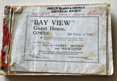
Booklet, Victorian Country Hotel & Guest House Guide 1939-40 "Where to go" in Victoria, 1939
Details of tourist accommodation options on the IslandHistoricalSmall, red bound booklet with maps, tables, descriptions and photos advertising tourist accommodation in country Victoria.Victorian Country Hotel & Guest House Guide 1939-40 "Where to go" in Victoriatourist brochure, bayview guest house, guesthouses, carisbrooke guesthouse cowes phillip island, cowes progress association, cora lynne, the isle of wight hotel cowes phillip island, phillip island hotel, douglas house, hollydene guest house, osborne park guesthouse, marldon house, bonnie doon, yackatoon, elsford, widgee -
 Rye RSL Sub Branch
Map Trench waterproofed cloth
A waterproofed cloth trench map of the Becelaere area, including Polygon Wood and other severely contested areas. -
 Ringwood and District Historical Society
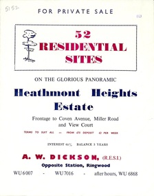
Flyer, Land Sale Brochure, Heathmont Heights Estate, Heathmont, Vic. - 1959
Bi-fold advertisement for sale of residential sites, including map and summary of subdivision features and local facilities. Subdivision includes Coven Avenue, View Court, and Miller Road. Agent - A.W. Dickson, Opposite Station. (Phone) WU6007, WU7016, after hours WU6868. -
 Ringwood and District Historical Society
Flyer, Land Sale Brochure, Heathmont Estate, Vic. - circa 1960
Advertisement for sale of residential lots - Heathmont Estate, opposite Heathmont Railway Station, with map and locality plan.Subdivision includes Canterbury Road, Royal Avenue, Coleman Street, Stoda Street, Herman Street, and Campbell Street. Agent - A.W. Dickson, opposite Station, Ringwood. Phone WU6007. -
 Ringwood and District Historical Society
Map, Allotments - Township of Ringwood - Parish of Ringwood - County of Mornington - 1886, 1886
[Page 3, Horse Shoes to High Heels - Richard Carter] ... "(In the year 1882) the railway was extended from Hawthorn through Ringwood to Lilydale and later to Ferntree Gully." Linen-backed map of Ringwood area lithographed at the Department of Lands and Survey, Melbourne, 5th November, 1886.old lilydale road, new lilydale road, victoria brick and tile co., ringwood brick co., federal brick co. -
 Federation University Historical Collection
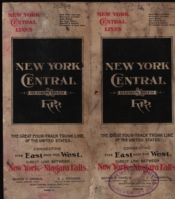
Map, New York Central Hudson River Map and Timetable
Henry Sutton is a talented world-wide accepted inventor with inventions relating to the telephone, photography, wireless, cars, motorcycles, and bicycles as well as many more inventions. Henry was also one of four brothers that ran the Sutton's Music Store after the death of their Father Richard Sutton. Henry Sutton taught Applied Electricity at the Ballarat School of Mines in 1883 to 1886.New York Central Hudson River Map and Timetable with red and black writing used by Henry SuttonUnion Steam Ship Company of New Zealand Limited stamp on the front.henry sutton, union steam ship company of new zealand limited, new york central, hudson river, map -
 Lara RSL Sub Branch
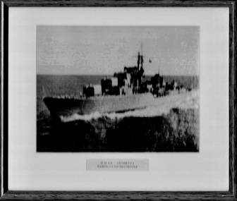
Framed Photo of H.M.A.S. VENDETTA Daring Class Destroyer
HMAS Vendetta was one of three Daring-class destroyers built for and operated by the Royal Australian Navy. The destroyer was built by Williamstown Naval Dockyard and entered service in 1958. During her early career, Vendetta was deployed to the Far East Strategic Reserve on multiple occasions. In 1965 and 1966, the destroyer undertook deterrence patrols during the Indonesia-Malaysia Confrontation. Along with several runs escorting the troop transport HMAS Sydney to South Vietnam, from late 1969 to early 1970 Vendetta was assigned to combat operations and became the only Australian-built warship to serve in a shore bombardment role during the Vietnam War. he ship underwent a two-year modernisation from 1971 to 1973, and in December 1974 was one of thirteen RAN warships involved in Operation Navy Help Darwin after Cyclone Tracy devastated Darwin. Several more deployments were made to the Far East, up until 1978. In October 1979, the destroyer was decommissioned, and served as a parts hulk for sister ship HMAS Vampire. Vendetta was sold for ship breaking in January 1987. 1002 Rectangular Shaped Glass Covered Photo Frame, 1002.1 H.M.A.S, VENDETTA FIRST COMMISSION MAP. H.M.A.S. VENDETTA Daring Class Destroyer. -
 Bendigo Military Museum
Album - Photographic Identification Guide (PIG) of the Gove Penisula (Sic) Peninsula, Army Topographic Support Establishment, May 1997
These photographs and a video were captured in May 1997 by Jeff Ruiz and Wayne Walsh from the Army Topographic Support Establishment (ATSE). The video taken onboard an aircraft has not been located at this time. A flight line diagram showing the path of the aircraft taking the video is enclosed in the album. The Army Topographic Support Establishment was created to perform some of the functions of the Army Survey Regiment.A Large Purple covered Album with gold dots containing maps, plans and coloured photographs of Gove Peninsula.royal australian survey corps, rasvy, fortuna, army survey regiment, army svy regt, asr, atse -
 Lara RSL Sub Branch
Book, Official History of Australia in the War of 1914-18 - Volume IX - The Royal Australian Navy Author A.W. Jose, 1937 fifth edition
Historically depicts the operations of the Royal Australian Navy duty occasioning navy vessels in addition to the drudgery of patrol work and the search for enemy vessels. Working in isolation because of being a vessel that is under their own control.This volume of the War Histories is concerned with the doings of an infant navy.Official History of Australia in the War of 1914-18 - Volume IX - The Royal Australian Navy Maps and Illustrationsgerman colonies, samoa, nauru, western pacific, africa, dardenelles, north atlantic, european waters, raiders and minefields, ran brigade, hospital ships, transports and dockyards, radio-telegraphy, suvla bay, sinking of the cumberland, german cruiser squadron, cocos, sydney-emden action, north sea -
 Lara RSL Sub Branch
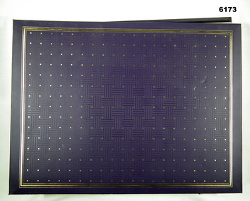
Book, The War 1939-1945 Edited by Desmond Flower and James Reeves Dedicated to the 30,000,000 dead, First Published 1960
A documentary conspectus of the worst war in history beginning at the German invasion of Poland 1939 and ending with the last Japanese surrenders in September - October 1945. This book is an attempt to put together a chronicle of how it actually felt to be alive, to see, to hear, to smell, to feel the war first hand.The War 1939-1945 - Printed 1960 Dark blue cover with ware and tear around the edges MapsDate stamps from HMAS Albatross library wwii, phony war, winter war, norway -
 Lara RSL Sub Branch
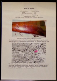
Framed Photograph and Rifle, Rifle - Styer. Made in Austria in 1875, 1875
The Boxer Rebellion, Boxer Uprising or Yihetuan Movement was a violent anti-foreign, anti-colonial and anti-Christian uprising that took place in China between 1899 and 1901, toward the end of the Qing dynasty.The Rifle was brought back to Australia by the Victorian Naval Brigade on their return from China. They had been involved in the surrender of Pao-ting Fu and as Garrison troops at Tianjin during the boxer Rebellion, serving from July 1900 to March 1901. Rifle - Styer. Made in Austria in 1875. Glass covered Rectangular Framed Photo and Map with a brief description.rifle,gun,styer rifle, boxer rebellion,lara r.s.l. -
 Bendigo Military Museum
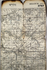
Map - TRENCH MAP WW1, 1917
Area covers from “Angre to Villers across the top, Louvignies to Wattignies across the bottom, the river Sambre runs through the bottom section” Item re William Alexander No 502 AIF. Refer Cat No 3746.3 for his service details. Map, Belgium and part of France, sheet 51, scale 1:40,000, Ordnance survey October 1917.map, belgium, trench -
 Bendigo Military Museum
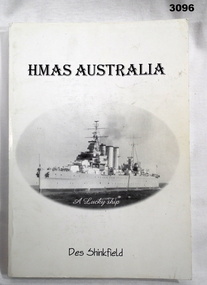
Book - BOOK, RAN, Des Shinkfield, HMAS Australia - A Lucky Ship, c.2001
Soft, cream cardboard cover re HMAS Australia. 198 pages. Copied photos, maps & drawings.books - naval history, illustrations, hmas, ran -
 Bendigo Military Museum
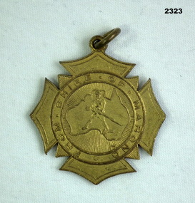
Memorabilia - BADGE, Est 1917
Thomas Alan Broadbent No 15887 46th Batt, KIA 20.9.18. Refer 2322.2 for service history also 2567P.Badge, metal, centre has map of Australia with a soldier centre, around the outside is "From Shire of Marong"On rear, "Presented to A Broadbent who enlisted for the Great War that commenced 4.8.1914"badges, presentation, shire -
 Bendigo Military Museum
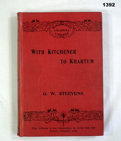
Book, William Blackwood and Sons, With Kitchener to Khartum, 1901
Volume 3 of The Works of George Warrington Steevens.Red buckram cover with title in black letters. 326 pages with cut edges. Contains coloured maps.Inside on 2nd page: Percy H Morcom 26.1.'02 from A.M. with many happy returnsbooks - history, military