Showing 23748 items
matching matthew-creek
-
 Eltham District Historical Society Inc
Album - Photograph, J.A. McDonald, Eltham-Greensborough Road, 1957
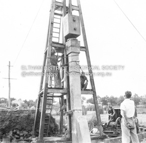
Diamond Creek Bridge (Bridge Street Bridge) Inner Vertical pile downstream side Eltham abutment This pile appalled at head after this blow. 1957Record of various Shire of Eltham infrastructure works undertaken during the period of 1952-1962 involving bridge and road reconstruction projects, sometimes with Eltham Shire Council Project Reference numbers quoted. It was during this period that a number of significant improvements were made to roads and new bridges constructed within the shire that remain in place as of present day (2022). In many situations, the photos provide a tangible visible record of infrastructure that existed throughout the early days of the Shire. The album was put together by or under the direction of the Shire Engineer, J.A. McDonald.infrastructure, road construction, shire of eltham, bridge construction, bridge street bridge, eltham, eltham-greensborough road, 1957 -
 Eltham District Historical Society Inc
Album - Photograph, J.A. McDonald, Eltham-Greensborough Road, 1957
Diamond Creek Bridge (Bridge Street Bridge) Inner Vertical pile downstream side Eltham abutment This pile appalled at head after this blow. 1957Record of various Shire of Eltham infrastructure works undertaken during the period of 1952-1962 involving bridge and road reconstruction projects, sometimes with Eltham Shire Council Project Reference numbers quoted. It was during this period that a number of significant improvements were made to roads and new bridges constructed within the shire that remain in place as of present day (2022). In many situations, the photos provide a tangible visible record of infrastructure that existed throughout the early days of the Shire. The album was put together by or under the direction of the Shire Engineer, J.A. McDonald.infrastructure, road construction, shire of eltham, bridge construction, bridge street bridge, eltham, eltham-greensborough road, 1957 -
 Eltham District Historical Society Inc
Negative - Photograph, J.A. McDonald, Heidelberg-Kinglake Road, Sep 1959
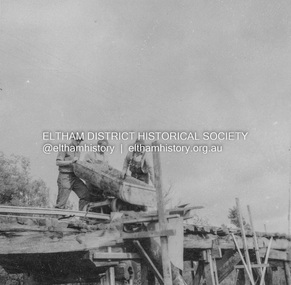
Job 56M430 Contractor Hone Just south of east abutment and access road to house showing block in table drain and wash towards Diamond CreekRecord of various Shire of Eltham infrastructure works undertaken during the period of 1952-1962 involving bridge and road reconstruction projects, sometimes with Eltham Shire Council Project Reference numbers quoted. It was during this period that a number of significant improvements were made to roads and new bridges constructed within the shire that remain in place as of present day (2022). In many situations, the photos provide a tangible visible record of infrastructure that existed throughout the early days of the Shire. The album was put together by or under the direction of the Shire Engineer, J.A. McDonald.infrastructure, shire of eltham, bridge construction, 1959-09, heidelberg-kinglake road, road construction -
 Eltham District Historical Society Inc
Negative - Photograph, J.A. McDonald, Heidelberg-Kinglake Road, Oct. 1959
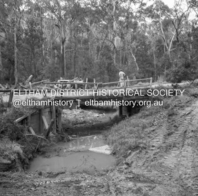
Job 56M431 Contractors Wolf and Wood Yow Yow Creek Bridge Showing condition October 1959 Bypass back upstream side under constructionRecord of various Shire of Eltham infrastructure works undertaken during the period of 1952-1962 involving bridge and road reconstruction projects, sometimes with Eltham Shire Council Project Reference numbers quoted. It was during this period that a number of significant improvements were made to roads and new bridges constructed within the shire that remain in place as of present day (2022). In many situations, the photos provide a tangible visible record of infrastructure that existed throughout the early days of the Shire. The album was put together by or under the direction of the Shire Engineer, J.A. McDonald.infrastructure, shire of eltham, bridge construction, heidelberg-kinglake road, 1959-10, road construction, scan - 120 format 6x6 negative, yow yow creek -
 Greensborough Historical Society
Newsletter, Greenhills and North Greensborough Progress Association, Community News: official journal of the Greenhills and Nth. Greensborough Progress Association and the Apollo Parkways Progress Association. 1980, 1980
Duplication of Diamond Creek Road : the first stage of the F5 Freeway, Community News welcome back! But the news is not good!, Thunder over the hill, And it came to pass... Newsletter, 6 p.greenhills and north greensborough progress association, greenhills, apollo parkways progress association, apollo parkways -
 Greensborough Historical Society
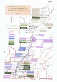
Maps, Yan Yean Water Supply System Conservation Management Plan: Construction dates Map 1, 2007_
Plan of Yan Yean Water Supply System, showing natural and constructed features from 1850s to 1930s from Silver Creek Weirs to Eastern Freeway.Printed in colour one side. 3 copieswater supply, yan yean reservoir, plenty river -
 Coal Creek Community Park & Museum
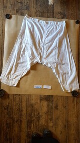
Ladies Nightdress and Undergarments, C1890
These garments were made by Evelyn Carfrae's grandmother for her trousseau around 1890. Evelyn Carfrae was a long time volunteer in O.Gilpins Store at Coal Creek.9056.1 Ladies long white nightdress with lace trimmed collar 9056.2 Ladies white mid calf length crotch less undergarment 9056.3 Ladies white calf length undergarment with drop down panel in front -
Coal Creek Community Park & Museum
trophy/cup
The 10 locals names and their scores are engraved on the front. Fish Creek were the runners up. A total of 6 teams competed in the competion from around the area. This trophy/cup is of social significance because it relates to the local Korumburra community in 1926. rifle club, trophy, guns, -
 Hume City Civic Collection
Photograph, Late 1990's
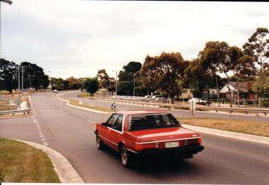
Riddell Road is the continuation of Macedon Street and is on the west side of the town centre. It is the main road to Riddells Creek, the Sunbury airstrip, Sunbury tip and water towers.A coloured photograph of Riddell Road looking west. A red car is in the foreground travelling north and is at the T intersection of Riddell Road and Ligar Street. There are houses along the north side of Riddell Road and the football ground is on the south side of the road.sunbury football club, riddell road, ligar street, george evans collection -
 Hume City Civic Collection
Photograph, late 1980s
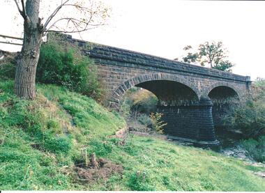
The road bridge over Jackson's Creek in Sunbury was built in 1870 and was in use until a wider bridge was built when Sunbury Road was rebuilt in the early 1970s.A coloured photograph taken from the NE side of the river bank of a complete view of the bluestone bridge at Macedon Street. The two eliptical arches and the protruding pylon as well as the underside of the bluestone span are clearly visible.transport, roads and bridges, jacksons creek, harris, thomas lascelles, george evans collection -
 Mont De Lancey
Book, JohnBurnham, Choral Anthems, 1892 is the dedication date inside. c.1899?
A collection of 114 beautiful Choral Anthems: festive music for use at Sunday School Anniversaries and other occasions.A dark green Choral Anthems book with the title printed in ornate gold lettering at the top of the front cover. 114 Beautiful Anthems is written in black letters with the compiler and Complete Volume below. There is a black floral lined border. The spine cover is missing. On the title page is printed along with a black lined picture of the compilers head: Choral Anthems. Beautiful Festive Music for Sunday School Anniversaries, &c. Compiled by John Burnham. Complete Volume with publisher details. There is a Dedication on the back of the title page. An Index to Choral Anthems is on the opposite page. p.256.non-fictionA collection of 114 beautiful Choral Anthems: festive music for use at Sunday School Anniversaries and other occasions.choral anthems, anthems, festive music, songs -
 Greensborough Historical Society
Magazine, Australia Post, Postscripts Spring 1992, 1992
The Australia Post Staff Journal contains work-related articles on postal services throughout Victoria. This edition includes an article on Diamond Creek Post Ofice. 32 p. magazine with black and green text and black and white photographs.diamond creek post office, postal services, australia post -
 Falls Creek Historical Society
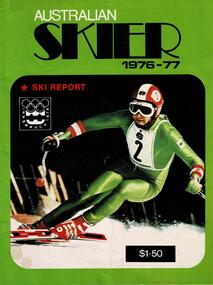
Magazine - Australian Skier 1976-77
This magazine documented activities and images from the Australian Ski Industry. Its editor, George Stock was an Instructor at both Perisher Valley and Falls Creek in the 1970s.This item is significant because it documents developments in skiing in Australia.A publication featuring a coloured image on the cover. Includes a selection of articles about skiing in Australia. The cover of this issue features the symbol of the Innsbruck Olympic Games.australian ski magazines, australian skier -
 Linton and District Historical Society Inc
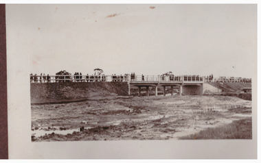
Photograph, Bridge Opening
Part of photograph album donated by Mrs Faull. The picture shows the opening of the Glenelg Highway Bridge over the Woady Yaloak Creek between Linton and Scarsdale.Black and white photograph of bridge opening. Bridge in background with people and cars.events, bridge openings, faull collection, woady yaloak creek -
 Bendigo Historical Society Inc.
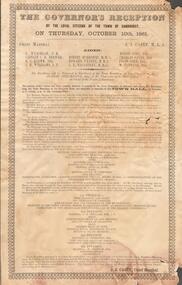
Document - GOVERNOR'S RECEPTION 1861
Victorian Governor, Sir Henry Barkly visited Bendigo in Oct. 1861 as part of his regional tour that included, Castlemaine, Chewton, Back Creek and Inglewood.Buff coloured document. Written on top 'The Governor's Reception by the Loyal Citizens of the Town of Sandhurst on Thursday October 10th 1861. The program for the day is detailed, with instructions as to the order that participants should muster before the greeting of the Governor at the City Boundary at Kangaroo Flat. 'His Excellency will be welcomed to Sandhurst at the Town Boundary at Two o'clock p.m by Robert Strickland Esq. J.P. Chairman of the Municipality on behalf of the People of Sandhurst'bendigo, council, governor's reception 1861 -
 Old Colonists' Association of Ballarat Inc.
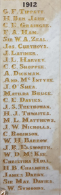
Photograph - Photograph - Colour, Marble Honour Boards listing benefactors to the Ballarat Old Colonists' Associations in 1912
Marble Honour Boards listing benefactors to the Ballarat Old Colonists' Associations. The name was added to the boards the year of the donors death. 1912 G.F. Tippett H. Ben Jahn C.E. Grainger F.A. Ham Sir W.A. Zeal Joseph Curthoys J. Latimer J.L. Harvey C.C, Shoppee A. Dickman Andrew McIntyre J. O'Shea Matilda Bruce C.E. Davies J.S. Trethowan h.J. Thwaites M.L. Matthews J.W. Nicholls C. Robinson W.H. Barrow J.R. Elsworth W.D. McKee Christina Hull H.B. Chalmers James Darby Sir Matthew Davies W. Symonds g.f. tippett, h. ben jahn, c.e. grainger, f.a. ham, sir w.a. zeal, joseph curthoys, j. latimer, j.l. harvey, c.c, shoppee, a. dickman, andrew mcintyre, j. o'shea, matilda bruce, c.e. davies, j.s. trethowan, h.j. thwaites, m.l. matthews, j.w. nicholls, c. robinson, w.h. barrow, j.r. elsworth, w.d. mckee, christina hull, h.b. chalmers, james darby, sir matthew davies, w. symonds, old colonists' association, marbles -
 Bendigo Historical Society Inc.
Photograph - GOLDEN SQUARE LAUREL STREET P.S. COLLECTION: YEAR 3-4 W 2000
Colour photograph of students : back row Mrs. John Wakker ( teacher) Hayden Dixon, Matthew Hope, Kirby Adams, Casey Buck, Julia Morris, James Penno, Kate Steele, Ms Jo Bury ( teacher) Middle row: Joshua Gordon, Douglas Holt, Lauren Stirling, Alanna Noulton, Sam Needs, Scott Owen, Luke Scoble, Monique Hardwick, Nicole Clayton, Tim Kalms, Kyle Owen, Henry Anderton, Front row Natalie Carter, Naomi sullivan, Chloe Boyd, D'Cara Williams, Jayden O'Brien, Tyrone O'Neill, Emily Zeralla, Lisa Downes, Stephanie Murphy.bendigo, education, golden square primary school year -
 Kew Historical Society Inc
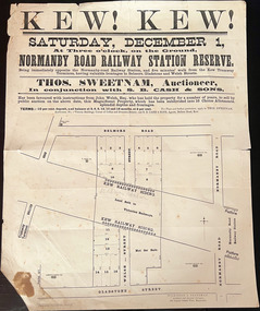
Plan, Kew! Kew!, 1888
The Land Boom of the 1880s accelerated the rate of subdivisions in Kew. This subdivision, 'Kew! Kew!' was also impacted by, or resulted from, the decision by the Victorian Government to construct the Outer Circle railway. Construction of the railway began in 1888 and was completed in 1891. Plan of an 1888 subdivision bounded by Bulleen Road (now High Street), Gladstone Street (now Campbell Street?), Park Street (now Adeney Avenue), and Belmore Road (now Harp Road). The 16 lots in the proposed subdivision are bisected by the route of the Outer Circle railway, and next to the proposed Normanby Station (later renamed East Kew). On the plan, local landmarks such as the tram terminus, the Harp of Erin hotel, and the station are located. The street where the lots are numbered , was called Welsh Street on the plan as this was the name of the vendor. Surrounding land owners are also named: G. Smith Esq, Matthew Maher Esq, and Maurice Neligan Esq.outer circle railway, land subdivisions -
![The Township of Walhalla / [by] Nicholas Caire, circa 1876](/media/collectors/550653872162f11fb04854aa/items/57825a89d0cdd1176ce3295a/item-media/57825aefd0cdd1176ce34515/item-fit-380x285.jpg) Kew Historical Society Inc
Kew Historical Society IncPhotograph, Anglo-Australasian Photographic Company, The Township of Walhalla, c. 1876
Nicholas Caire was born on Guernsey in the Channel Islands in 1837. He arrived in Adelaide with his parents in about 1860. In 1867, following photographic journeys in Gippsland, he opened a studio in Adelaide. From 1870 to 1876 he lived and worked in Talbot in Central Victoria. In 1876 he purchased T. F. Chuck's studios in the Royal Arcade Melbourne. In 1885, following the introduction of dry plate photography, he began a series of landscape series, which were commercially successful. As a photographer, he travelled extensively through Victoria, photographing places few of his contemporaries had previously seen. He died in 1918. Reference: Jack Cato, 'Caire, Nicholas John (1837–1918)', Australian Dictionary of Biography.An original, rare photograph from the series 'Views of Victoria: General Series' by the photographer, Nicholas Caire (1837-1918). The series of 60 photographs that comprise the series was issued c. 1876 and reinforced a neo-Romantic view of the Australian landscape to which a growing nationalist movement would respond. Nicholas Caire was active as a photographer in Australia from 1858 until his death in 1918. His vision of the Australian bush and pioneer life had a counterpart in the works of Henry Lawson and other nationalist poets, authors and painters.‘The Township of Walhalla’ : Views of Victoria (General Series) No.37 : Albumen silver photograph | Photo on card with Title and Description on reverse | Mounted 24 x 30 cm; Photo 12 x 17 cm.On Reverse: ‘This romantic Township is situated near Stringer’s Creek in Gipps Land, not far from the celebrated Baw-Baw Mountains. The Long Tunnel Gold Claim has proved a great source of wealth to this small out-of-the-way place, yielding sometimes between 2,000 and 3,000 ounces of gold per month. The population, which is mostly a mining one, reaches nearly 2,000 inhabitants, and are scattered about among the creeks and gullies of the neighbourhood. Until recently, the road traffic was limited to pack-horses, in consequence of the precipitous hills which surround the Town.‘nicholas caire (1837-1918), walhalla, landscape photography -
Eltham District Historical Society Inc
Document - Folder, McGahy, David
David McGahy OAM, who died 19 April 2014, was CFA Captain for Arthurs Creek and Strathewen on Black Saturday. Jim Usher had written a book about those fires and described McGahy's life and work for the community. Helen Kenney commented on his life. Contents Newspaper article: "Tributes for bushfire hero," Diamond Valley Leader, 30 April 2014, describes David McGahy's work for the Country Fire Authority in Arthurs Creek and Strathewen.Newspaper clippings, A4 photocopies, etcdavid mcgahy oam, jim usher, helen kenney, black saturday, arthurs creek victoria, strathewen victoria -
Glenelg Shire Council Cultural Collection
Photograph - Contact Print - Portland, Victoria, 1970s
Sheet of 2 contact prints from glass plate negatives. Top: Group of people on and near a bridge over creek. Bushland setting. Bottom: 3 men and 3 women standing on bank of river. Surrounding area flat, almost treeless. Sandy soil. People dressed in fashion of late 19th, early 20th century.photography, contact print, bushland, glenelg shire -
Federation University Historical Collection
Map, Otways Walks and Waterfalls Map, 2013, 06/2013
Tourist map of the Otways showing the townships of Colac, Lorne, Apollo Bay, Beech Forest, Forrest, Barwon Downs, Deans March, Winchelsea, Gellibrand, Lavers Hill, POrt Campbel, Princetown, Johanna, Timboon, Cobden, Camperdown, Swan Marsh, Simpson, Birregurra, Beeac, Marengo, Wye River, Kennett River, Skenes Creek, Peterboroughcolac, lorne, apollo bay, beech forest, forrest, barwon downs, deans march, winchelsea, gellibrand, lavers hill, port campbel, princetown, johanna, timboon, cobden, camperdown, swan marsh, simpson, birregurra, beeac, marengo, wye river, kennett river, skenes creek, peterborough< marriners falls, beauchamp falls, hopetoun falls, triplet falls, little aire falls, stevensons falls -
 Federation University Historical Collection
Booklet, Northern Territory ... The Tanami Gold Country with Plans, 1909, 1909
Pink foolscap report of 12 pages, includes geological map from Pine Creel to Sturt's Creek by H.Y. L. brown; geological map between Mucka and Gordon Downs Station and Tanami by W.R. Murray; geological map of Tanami and surrounding country by W.R. Murray, and Plan of Lawne's Gold Prospecting Claim at Tanami by W.R. Murray pine creek, sturt's creek, tanami, northern territory, tanami gold country -
 Bendigo Historical Society Inc.
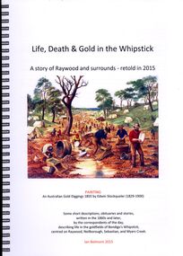
Book - LIFE DEATH & GOLD IN THE WHIPSTICK
Life Death & Gold in the Whipstick, a story of Raywood and surrounds - retold in 2015, some short descriptions, obituaries and stories written in the 1860s and later by the correspondents of the day describing life in the goldfields of Bendigo's Whipstick, centred on Raywood, Neilborough, Sebastian and Myers Creek. 117 pages, spring bound with plastic cover, contains maps, illustrations and photographs.Ian Belmonthistory, australian, raywood -
 Bendigo Historical Society Inc.
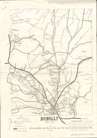
Document - JOAN O'SHEA COLLECTION: DUNNOLLY MAPS, 1980
Joan O'Shea Collection. Goldfield Maps Dunolly 3 Sheets 1980. Page 1: Mines in Dunolly, Whistling Flat, Painswick and Surrounds. Page 2: Mines in Goldsborough, McKinnons Gap, Bealiba Range, Stewarts Flat and Surrounds. Page 3: Mines in Dunolly, Emu Creek, Bet Bet, Bromley & Surrounds. Scale in Chains and Kilometres.GoldField Maps 1980 based on Dunolly 7624 by Division of National Mappinggold, goldfields, goldfield maps dunolly & surrounds -
Bendigo Historical Society Inc.
Map - HEATHCOTE : COUNTY OF BENDIGO, 11-4-35
Map. Heathcote, County of Bendigo, County of Dalhousie,Township of Heathcote, McIvor Creek, Argyle Station Ground, Wallan and Bendigo Railway, C.R.B. Main Road. By authority H.J. Green, Govt. Printer. Photo-Lithographed at the Department of Lands and Survey, Melbourne. 11-4-35. Price 2/-. (number 88 in map cupboard 1)H.J. Green, Govt.Printermap, bendigo, heathcote -
 Bendigo Historical Society Inc.
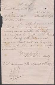
Document - ANCIENT ORDER OF FORESTERS NO. 3770 COLLECTION: CORRESPONDENCE
Letter dated March 28 '73. It mentions that it is o no consequence whether the cash is remitted by the Bro or the Court, as long as he is not allowed to run unfinancial. Signed Tho Wilson Secty. PS Arrears 5/3 April 8 1873.Top of the letter shows -A.O.F. Court Campbells Creek No 3784 Mr B Evans Esqsocieties, aof, correspondence, ancient order of foresters no. 3770 collection - correspondence, court campbells creek no 3784, w b evans, w sammans, tho wilson -
Bendigo Historical Society Inc.
Map - SALISBURY WEST : COUNTY OF BENDIGO, 24-6-24
Map. Salisbury, County of Bendigo, County of Gladstone, Powlett, Yarrayne, Bridgewater, Inglewood, Glenalbyn, Kurting, River Loddon, Bulabul Creek. By authority A.J. Mullett, Government Printer, Melbourne. Photo-Lithographed at the Department of Lands and Survey, Melbourne by W.J. Butson, 24-6-24. Price 1/-. (number 116 in map cupboard 1)A.J. Mullett, Government Printer, Melbourne.map, bendigo, salisbury west -
Bendigo Historical Society Inc.
Map - HAWKESTONE : COUNTY OF BENDIGO, 7-11-15
Map. Hawkestone, County of Bendigo, County of Talbot, Lyell, Sutton Grange, Redcastle, Elphinstone, Metcalfe, Coliban River, Myrtle Creek. Albert J. Mullett, Government Printer, Melbourne. Photo-Lithographed at the Department of Lands and Survey, Melbourne by W.J. Butson,7-11-15. Price 1/-. (number 111 in map cupboard 1)Albert J. Mullett, Government Printer, Melbourne.map, bendigo, hawkestone. -
Bendigo Historical Society Inc.
Map - HARCOURT, December 1951
Harcourt, County of Bendigo, Walmer, Castlemaine, Sutton Grange. Mt.Alexander Trig. Station, Barkers Creek, Faraday, Calder Highway, Northern Railway. By Authority J.J.Gourley, Government Printer, Melbourne,Drawn and Reproduced at the Dept. of Lands and Survey, Melbourne, Victoria. December 1951. Price 5/-per sheet. (number 35 in map cupboard 1)J.J.Gourley, Government Printer, Melbourne.map, bendigo, harcourt