Showing 11146 items matching " planning"
-
 Falls Creek Historical Society
Letter - Request Permission To Use Building Known As The "Annexe"
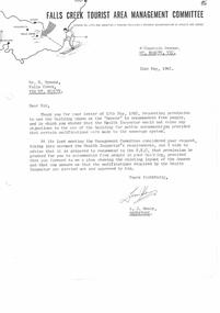
Bob (Herman) Hymans (a former member of the Royal Netherlands Navy) was born in Bloemendaal, Holland on 30th September 1922. During World War II he fought against the Japanese in the Dutch East Indies (now Indonesia) and was imprisoned in Changi and on the Burma Railway. After gaining qualifications as a Ski Instructor, Bob arrived in Falls Creek in July 1950. Working as an Instructor and Supervisor at Bogong Lodge, Bob decided his future was in accommodation. He was successful in negotiating an indenture for land from the State Electricity Commission (SEC). It took Bob two years to build his Grand Coeur Chalet but, tragically, it was burned down in August 1961. Bob also built the first Chairlift in Australia. This was a single chairlift and the structure was built from wooden electricity poles. He was constantly full of new ideas and proposals for the village. Bob Hymans died on 7th July 2007. This Collection of documents and letters tells the story of Bob's endeavours to develop Falls Creek into the ski village it is today.This letter is significant because it reflects the relationship between Bob Hymans and the Management Committee.A letter from the Management Committee to Mr Hymans in response to his request to use "The Annexe" to accommodate five people. The Committee would recommend to the SEC that approval be granted subject to the provision of a plan of the layout. Modifications in line with Health Departments requirements also had to be completed.falls creek tourist area management committee, bob hymans, "the annexe" falls creek -
 University of Melbourne, Burnley Campus Archives
Plan, Wilsons Promontory8119-I and Glennie 8119-IV, 1971
State Aerial Survey Plan of Wilsons Promontory and Glennie. Dated 1971. Provisional Compilation of Sheets 8119-I and 8119-IV from Commonwealth Department of National Development Photography for the Department of Crown Lands and Survey Victoria. Students made excursions to Wilsons Promontory.wilsons promontory, glennie group, anser group, bass strait, aerial survey -
 Melbourne Tram Museum
Book, Met Tram, "An introduction to AS/NZS ISO 9002:1994", Apr. 1997
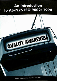
Book - 16 pages - A5 - Centre stapled titled "An introduction to AS/NZS ISO 9002:1994" - setting out a plan by The Met / PTC during 1997. Training and awareness document about Quality process. Has a forward by Russell Nathan dated 4.4./1997.trams, tramways, training, quality, safety, met tram -
 Melbourne Tram Museum
Ephemera - Auction Brochure, Marshall White One, Feb. 2014
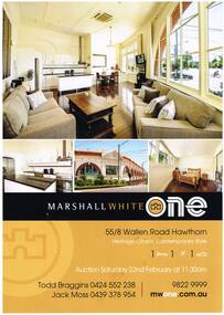
Auction brochure - for unit 55, the corner apartment at the former Hawthorn Tram Depot. Has photos of the unit, details, floor plan and Real Estate agent details, auction dates and contact numbers. Was to be auctioned by Marshal White One on Saturday 22/2/2014.trams, tramways, hawthorn tram depot, auctions, real estate -
 Bacchus Marsh & District Historical Society
Map, 'Map of Darley' circa 1877-1897
This map shows the early laid out streets and roads for the village of Darley and the main roads and streets in the central area of the township of Bacchus Marsh. The date of the map is not known. Landmarks indicated on the map including the Anglican Church in Church Street (Gisborne Road), opposite the Presbyterian Church, and the Baptist Church at its pre-1898 Main Street location suggest the map is dated between 1877 and 1897. Landholders names can be seen on some of the allotments of land marked in this map, including the names Clifton, Cosgrove, O'Hagan, McFarlane, Nagle, O'Hagan, Simpson and Vallence.A single page paper map showing the village of Darley and the township of Bacchus Marsh. Scale 10 chains to 1 inch. The map is pasted into a bound volume containing 76 maps or plans in total. High resolution digital image stored on BMDHS computer network. darley victoria maps, bacchus marsh victoria maps -
 Bendigo Historical Society Inc.
Plan - MARKS COLLECTION: LANSELL'S 180 PLAN, LEVELS 18, 19 AND 20
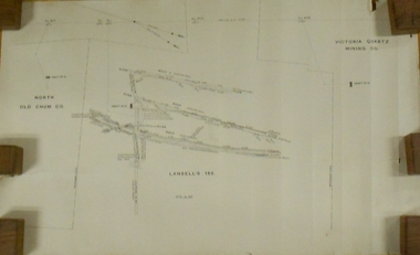
Plan of underground section of Lansell's 180 mine, levels 18, 19 and 20. On RH side of map Victoria Quartz Mining company claim marked, on LH side North Old Chum Co. 'West or hanging wall' marked above each level.bendigo, mining, lansell's little 180 mine -
 Bacchus Marsh & District Historical Society
Map, Mooradoranook Parish Map, County of Grant
A single page paper map showing the map for the Parish of Mooradanook in the County of Grant. Cadastral map showing land ownership. The map is pasted into a bound volume containing 76 maps or plans in total. High resolution digital image stored on BMDHS computer network. Photo lithographed at the Department of Lands and Survey Melbourne by T. F. McGauran, 27.11.06mooradoranook parish maps, mooradoranook parish plan, bacchus marsh region parish plans -
 Bacchus Marsh & District Historical Society
Map, Mouyong Parish Map, County of Grant
A single page paper map showing the map for the Parish of Mouyong in the County of Grant. Cadastral map showing land ownership. The map is pasted into a bound volume containing 76 maps or plans in total. High resolution digital image stored on BMDHS computer network. Photo lithographed at the Department of Lands and Survey Melbourne by T. F. McGauran, 9. 4. 07mouyong parish plan, mouyong parish maps, bacchus marsh region parish plans -
 Warrnambool and District Historical Society Inc.
Book, Pam Marriott (publisher), Top Dog of the West, 2017
This book, written by Pam Marriott, is subtitled ‘A Study of the Belfast and Western District Civil Service 1841-1886’. It contains information on the police, police magistrates, court officials, customs and immigration officials etc who lived and worked in the Port Fairy and Warrnambool districts in the 19th century and many of the incidents and events with which they were connected. The book includes much information that is relevant to Warrnambool’s past. This book is an important acquisition to the Warrnambool & District Historical Society library as it contains information on many 19th century Warrnambool personalities, including policemen and court officials. It also has detailed information on some events that occurred in the Warrnambool district in the 19th century. This is a soft cover book of 480 pages. The cover and spine are white, with a black and white photograph and black printing. The pages include an introduction, eleven chapters of printed material, an index, a bibliography and appendices. There are several black and white photographs, plans, maps and other illustrative material. western district 19th century history, western district civil service 19th century, history of warrnambool -
 Ringwood and District Historical Society
Document - Research Notes, Richard Carter, Land Subdivisions in Ringwood 1890-1950
Handwritten table listing main local pre-1950s subdivisions in the Ringwood area, with estate names, streets, number of allotments for sale, and where known, vendor agent, LP (Lodged Plan) title registration number, and auction/sale date, some with sale price.Pg1 RINGWOOD STATION ESTATE LP3070 (Year?) Station Street, William Street (now Kendall Street), Wantirna Road, Station Street Pg1 RINGWOOD TOWNSHIP ESTATE LP5577 (1913) Station Road (now Warrandyte Road), Pratt Street (part now Aird Street), Whitehorse Road Pg2 RINGWOOD ORCHARD ESTATE LP4315 (1914) Brysons Road, Hillcrest Road, Anzac Avenue, Sulva Road Pg3 RINGWOOD RAILWAY ESTATE LP7522 (1918) Whitehorse Road (now Mount Dandenong Road), Dublin Road, Freeman Street, Patterson Street, Bona Street Pg4 THE RINGWOOD ESTATE LP7578 (1919) Warrandyte Road, Hobart Street, Paxton Street, Arnold Street Pg5 GARDEN FARMS ESTATE (LP?) (1919) Canterbury Road, Armstrong Road, Bungalook Road, Orchard Road, Bayswater Road (now Mountain Highway) Pg6 THE RINGWOOD ESTATE (SECOND SUB-DIVISION) LP7604 (1919) Warrandyte Road, Tamar Street, Derwent Street, Mersey Street Pg7 RINGWOOD STATION ESTATE LP7703 (1919) Bedford Road, Williams Grove (now Lena Grove) Pg8 RINGWOOD TOWNSHIP ESTATE LP8198 (1919) Wantirna Road, Ellison Street, Haig Street, Greenwood Avenue Pg9 EASTFIELD ESTATE (LP?) (1920) Eastfield Road, Longview Road, Pleasant Rise, The Mount Pg10 ELECTRIC RAILWAY ESTATE RINGWOOD LP9473 (1922) Campbell Street, Myrtle Avenue, George Street (now Tudor Court), Henry Street (now Myrtle Avenue), Williams Grove (now Lena Grove) Pg11 RINGWOOD PARK ESTATE LP7884 (1922 - two stages) Wonga Road (now Loughnan Road), William Street, Andrew Street, Harrison Street Pg12 HEATHMONT STATION ESTATE LP11009 (Date? - after 1922) Lisgoold Street, Viviani Crescent, Balrour Avenue, Station Street (now part Heathmont Road and part Wainui Street) Pg13 RINGWOOD RAILWAY ESTATE LP10507 (1923) Whitehorse Road, Sherbrooke Avenue, Burwood Avenue, Bonview Avenue, Heatherbrae Avenue, Grant Crescent Pg14 GARDEN HOMES ESTATE (LP?) (1923) Mullum Road, The Centreway, Wattle Crescent (now Wattle Avenue) Reserve Crescent (now Reserve Road) Pg15 DUBLIN ROAD ESTATE LP11993 (1923) Alexandra Road, Vonadawn Avenue, Green Street, Wood Street, Howard Avenue, Bedford Road, Dublin Road Pg16 CARLINGA ESTATE RINGWOOD LP9620 (1923) Bourke Street, Bond Street, Ringwood Street Pg17 PRATT'S JUNCTION ESTATE (LP?) (1923) Junction Street, Georges Road, Oliver Street, Whitehorse Road Pg18 EAST RINGWOOD ESTATE LP10492 (1923) Bona Street, Patterson Street, Miller Grove, Fairview Avenue, Eastfield Road, Whitehorse Road (now Mount Dandenong Road) Pg19 COLEMAN'S HEATHMONT ESTATE LP9974 (1923) Canterbury Road, Bedford Road, Alvena Crescent, Coleman Street, Leonard Street (now Royal Avenue) Pg20 RINGWOOD HEIGHTS ESTATE LP10506 (1924) Whitehorse Road, Bonview Avenue, Grant Crescent, Hillcrest Avenue, Heatherbrae Avenue, Margaret Street, Mary Street Pg21 EAST RINGWOOD STATION ESTATE LP10551 (1924) Knaith Road, Wenwood Street, Lois Street, Victoria Street, Station Street (now Railway Avenue) Pg22 GRAND VIEW ESTATE LP11019 (1924) Whitehorse Road, Rupert Street, Herbert Street, Leonard Street Pg23 RINGWOOD RAILWAY ESTATE & RINGWOOD HEIGHTS ESTATE - FINAL SECTIONS LP10506 & LP10507 (1924) Whitehorse Road, Sherbrooke Avenue, Burwood Avenue, Bonview Avenue, Heatherbrae Avenue, Margaret Street, Mary Street, Grant Crescent Pg24 RINGWOOD EAST ELECTRIC STATION ESTATE (LP?) (1924) Railway Parade (now Patterrson Street), Federal Road, Howship Avenue (part now French Street), Dublin Road, Rosedale Crescent Pg25 BEDFORD PARK (now Ringwood Secondary College) (LP?) (1924) Bedford Road, Adams Street, Anderson Street, Joyce Street, Graham Road Pg26 CROWN JEWEL ESTATE LP11645 (Private sales after 1924) Mount Dandenong Road, Mirabel Avenue, Valda Avenue, Evon Avenue, Velma Grove Pg27 GRAND CENTRAL ESTATE LP10917 (1925) Heathmont Road, Great Ryrie Street, Douglas Street, Garden Street, Bellevue Avenue Pg28 RINGWOOD (unnamed estate - 1926) Nelson Street, Seymour Street, Whitehorse Road Pg29 EAST RINGWOOD RAILWAY STATION ESTATE (YEAR? - 25 shops 60 villas) Railway Avenue, Dublin Road, Lawrence Grove, Stanley Avenue, Knaith Road Pg30 CHARM VIEW ESTATE (LP?) (year? - after 1926) Canterbury Road, Heathmont Road, Dickasons Road, Bennjett Avenue, Orchid Street Pg31 SUNBEAM ESTATE LP12150 (Circa 1925) Govt Road (now Old Lilydale Road), Sunbeam Avenue, Holland Road, Everard Street (now Everard Road) Pg32 FAIRVIEW ESTATE EAST RINGWOOD LP10853 (Circa 1924) Eastfield Road, Patterson Street, Margaret Street (now Short Street) Pg33 EAST RINGWOOD TOWNSHIP ESTATE LP3025 (Circa 1924 - 35 allotments) Mount Dandenong Road, Grey Street, Eastfield Road Pg34 EAST RINGWOOD TOWNSHIP ESTATE LP3025 (Circa 1924 - 49 allotments) and STATE SCHOOL ESTATE (26 allotments) and EAST RINGWOOD STATION ESTATE (14 shop sites) Mount Dandenong Road, Grety Street, Dunn Street, Eastfield Road, King Street, Holland Road, Dublin Road, Patterson Street, Bona Street Pg35 EAST RINGWOOD CENTRAL ESTATE LP17004 (1948) Knaith Road, Shasta Avenue, Talofa Avenue, Russet Road, Dublin Road Pg36 WARE ESTATE LP43360 (1958) Ware Crescent, Davey Drive, Grey Road (now Grey Street), Mount Dandenong Road Pg37 Lot 57 Kendall Street LP3070 (1939) £75.0.0 Pg37 Lot 14 LP7346 (year?) £225 Pg37 Lot 8 WHITE HORSE ESTATE LP14010 (year?) Maroondah Hwy, Seymour Street £98.9.0 Pg37 Lots 4-14 incl. LP10902 (year?) £300 Pg37 Lots 69&70 LP2216 (1939) Bedford Road, Pitt Street £500 Pg37 Lots 60&70 LP2216 (year?) £460 Pg37 MOUNTAIN VIEW ESTATE LP10902 (1936) Lots 1&2, 19-22 Wantirna Road, Daisy Street £50 Pg38 RAILWAY STATION ESTATE RINGWOOD EAST LP7522 (1925) Lots 16 to 19 £250 Pg38 RINGWOOD PARK ESTATE (LP?) (1924) Lot 112 Munro Street £230 Pg38 RINGWOOD TOWNSHIP ESTATE (LP?) (1925) Lot 57 Wantirna Road £850 Pg38 ELECTRIC RAILWAY ESTATE LP9473 (1925) Lot 98 & 99 £180 (30/- foot) Pg38 ELECTRIC RAILWAY ESTATE LP9473 (year?) Lot 100 £233.12.6 incl improvements (£2.12.6 foot) Pg38 Lot 22&23 Bedford Road Heathmont (LP & year?) £675 incl improvements Pg39 Lot 9 Mullum Mullum Road LP8221 (1923) £150 Pg39 Lot 27 Haig Street LP8198 (1925) £825 Pg39 Lot 56 Haig Street cnr Wantirna Road LP8198 (1923) £171 Pg39 Lots 3 & 4 Loughnan Road LP9626 (192?) £147 Pg39 Lots 98 & 99 Myrtle Avenue LP9473 (1925) £180 Pg39 Lots 80 & 81 Myrtle Avenue LP9473 (1929) £150 Pg39 Lot 30 Sherbrooke Avenue LP10507 (1926) £700 incl improvements Pg40 Lot 10 (year?) LP7703 £750 Pg40 Lot 36 (year?) LP7522 £25 Pg40 Lot 38 Pitt Street LP2216 (year?) £350 Pg40 Lot 7 Dublin Road cnr Green Street LP11993 (year?) £300 -
 Bendigo Historical Society Inc.
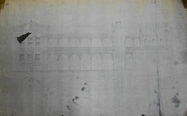
Document - MARKS COLLECTION: COPY OF DRAWING OF FORTUNA
Photocopy of plan of Fortuna (front view) showing front and side elevation. On LH side of front elevation, 3 windows on first floor, two beneath at each side of door. In centre,6 arches in balcony, and 6 below. Good definition of verandah lacework.buildings, house, fortuna villa -
 Ringwood and District Historical Society
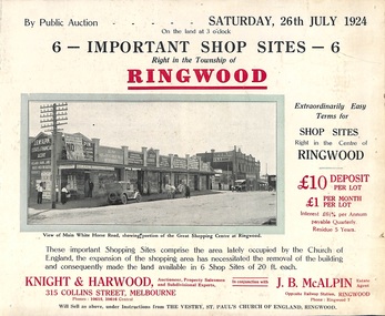
Flyer, Shop Sites Sale By Public Auction, Ringwood, Victoria - 1924
Folded double-sided brochure advertising six Ringwood shop sites for sale by Public Auction at 3pm, Saturday, July, 1924, with town photographs, location map, and summary of local features and services. Includes newspaper extract from the Real Estate and Property section from "Evening Sun", 6th June, 1924.Locality plan highlights shop sites for auction east of Pratt Street along Whitehorse Road. (Agents) Knight & Harwood, 315 Collins Street, Melbourne, Phones 10615, 10616 Central, in conjunction with J.B. McAlpin, Estate Agent, Opposite Railway Station, Ringwood, Phone Ringwood 7. -
 Ringwood and District Historical Society
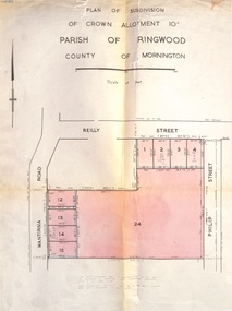
Document, Plan of Subdivision - Part of Crown Allotment 10A, Parish of Ringwood, County of Mornington - 1957
Map of residential allotments in Wantirna Road and Reilly Street, Ringwood, and Philip Street, Heathmont, Vic.Footnote includes "Lots numbered 5 to 11 and 16 to 23 both inclusive are not included in this plan. Signature of Consulting Engineer - Alan J. Brown BCE, LS, MVIS, Licensed Surveyor, Dillons Buildings, 1 Riversdale Road, Camberwell (Phone) WF3528 dated 1-4-1957. -
 Glen Eira Historical Society
Document - Japanese School of Melbourne
Six documents about the Japanese School: 1/The Japanese School of Melbourne Planning Brief document draft February 1984 to the City of Caulfield. Brief includes background of school, current educational standards of school and structure, future plans, including forecast of future student numbers, request to use prefabricated rooms. Also plans for new building and room alterations. Includes appendice which has current and projection graph of students attending. Period covered: January 1968-February 1984 (17 pages). 2/Fourteen page school prospectus, which includes history and location, term dates, school hours, curriculum subjects, teachers qualifications, health department approval and enrolment list. Also includes Division of School Duties, school educational aims and guidance priorities. Period covered: 07/09/1968-13/05/1986. 3/An 11/11/1988 Melbourne Development and Prospectus for the Japanese School of Melbourne, includes purpose of school, development options, planning brief, construction time, and development program. Includes seven plans and maps of school location and bus routes (14 pages). Prepared for the City of Caulfield on its request. 4/List of representatives of the Japanese School of Melbourne that met with City of Caulfield councilors on 23/11/1988. 5/Black and white photo of 'Ian Rob with Japanese students September 1991', six students included. 6/Colour photograph of 'Mayor Ed Biggs with Japanese students February 1992', thirteen adults and young people included.japanese school of melbourne limited, japanese school, caulfield, holy cross catholic, holy cross school, ellington school, keeron street, mockridge stahle and mitchell architects, architects, secondary schools, primary schools, playgrounds, hawthorn road, caulfield south, yaji hidero, japanese community, yazaki yasuo, morita hiroshi, teachers, bloink des, stokes tony, building surveyors, japanese supplementary school of melbourne, school committees, libraries, school houses, brick, bloink clarke harding consulting architects group, anthony stokes and assoc. building surveyors and town planners, rob ian, biggs ed mayor -
 Bendigo Military Museum
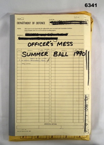
Administrative record - Army Survey Regiment Officers Mess Ball 1990, Army Survey Regiment, Bendigo, 12 Feb - 8 Mar 1990
The Army Survey Regiment held Annual Balls at Fortuna Villa. This folder contains the documentation for the Logistics and activities associated with the planning and running of the Officers Mess Summer Ball held in 1990.Manilla Correspondence Folder with grey cloth binding containing correspondence about the Army Survey Regiment Officers Mess Summer Ball of 1990.royal australian survey corps, rasvy, fortuna, army survey regiment, army svy regt, asr -
 Warrnambool and District Historical Society Inc.
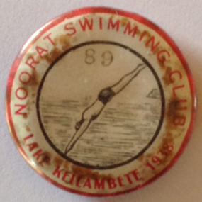
Badge - Noorat Swimming Club 1938, 1938
In 1923 there were plans to form a swimming club at Noorat. The club intended to erect a jetty and sheds at the north end of Lake Keilambete. It also proposed teaching school children to swim.The badge came from Murray Murfett a Warrnambool Council employee. It came from his father’s property in Terang in 2014. Cream circular metal badge with red lettering. Illustration of diver and water. 89 lake keilambete, noorat swimming club, 1938. -
 Mission to Seafarers Victoria
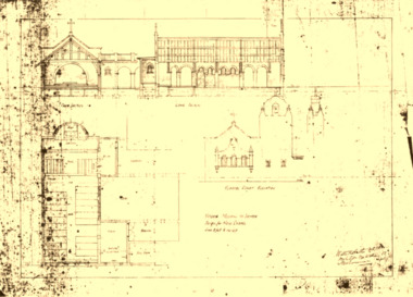
Drawing - Architectural drawing, photocopy, Walter Butler, New Buildings for the Missions to Seamen, c. 1916
Draft drawing for the new Flinders Street building designed by Walter Richmond Butler. The copy was published in the 2002 conservation plan without mentionne the source. The original has not been located.The drawing shows the first design of the chapel, the intented position of the weathervane, the absence of chaplain's residence and dome.A3 photocopy in black and white of an architectural drawing depicting the facade.walter richmond butler (1864–1949), flinders street, building, built heritage -
 Mission to Seafarers Victoria
Drawing - Architectural drawing, photocopy, Walter Butler, A Rough Sketch of the Design for the New Buildings for the Missions to Seamen, Flinders Street, Melbourne, c. 1916
Rough sketch for the new Flinders Street building designed by Walter Richmond Butler. The copy was published in the 2002 conservation plan without mentionne the source. The original has not been located.The drawing shows the first design of the chapel, the intented position of the weathervane, the absence of chaplain's residence and dome.2 A3 photocopies glued in black and white of an architectural drawing depicting the facade.walter richmond butler (1864–1949), flinders street, building, sketch, built heritage -
 Mission to Seafarers Victoria
Drawing - Architectural drawings, Walter Butler, Victoria Missions to Seamen, Design for the New Chapel, September 1916
Rough sketch for the new Flinders Street building designed by Walter Richmond Butler. The copy was published in the 2002 conservation plan without mentionne the source. The original has not been located.The drawing shows the first design of the chapel, the intented position of the weathervane, the absence of chaplain's residence and dome.Original drawing for the new chapel with signature of Walter Butlerwalter richmond butler (1864–1949), flinders street, building, sketch, built heritage -
 Greensborough Historical Society
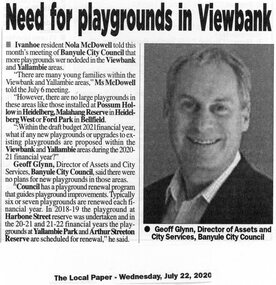
Article - Newspaper Clipping, Need for playgrounds in Viewbank
Banyule Council was questioned on the possibility of new children's playgrounds in the Viewbank and Yallambie areas. A Council officer responded that several playgrounds are due for renewal in the coming years, but no new playgrounds are planned.News clipping, black and white text and image.banyule council, yallambie, viewbank, playgrounds -
 Greensborough Historical Society
Newspaper Clipping, Diamond Valley Leader, Champ has hoop dreams, 13/01/2016
Montmorency student Liam Doherty won gold in shot put at a School Sports Australia event in Canberra in December 2015. Pickett plans to pursue a career as a professional basketballer in the future.News clipping, black text, colour image.school sports australia, diamond valley basketball association, liam doherty -
 Ringwood and District Historical Society
Collection, Heatherdale PS 4904, Theme Week, Jun-82
Planning documents from teachers asking for props for their 'Australia in the Good Old Days' 1900-1930 theme week. Newspaper reports with photos of Sara Legg and Tracey Duff in costume.Theme week needs at Heatherdale PS.No 4904 ,list of needs dated17 June 1982 and 2 newspaper clippings a) Nunawading Gazette 23 June1982 b) eastern Standard 1982 +Additional Keywords: Legg, Sara / Duff, TraceyMcGinley, Rex (Headmaster) -
 Port Melbourne Historical & Preservation Society
Badge - I am a friend of the park, Pat Grainger, 1987
Used at a 1987 community picnic and the Port Melbourne Festival 1988 after Vic.Govt. announced plans to create a "Boulevard" along the Railway in order to provide an upmarket approach to the Bayside Development.Large, pale pink badge "I am a friend of the park" from 1987 protest group against establishment of a major road along the railway reserve."Badge - A - Minit" and logo impressed on backpublic action campaigns, town planning - proposals shelved, town planning - proposals shelved - bayside, friends of the park -
 NMIT (Northern Melbourne Institute of TAFE)
Manual: Programs Manual NMIT, Programs Manual 1997. NMIT, 1997
This folder contains documents relating to internal organisation, policies and procedures of Northern Melbourne Institute of Technology. It includes organisational flowcharts and procedures for enrolment and planning of recurrent and customised programs and courses. This manual provides a snapshot of the responsibilities of both the organisation and staff in the 1990s.White loose leaf binder with blue insert in front cover. Contents include documents relating to internal organisation, policies and procedures of Northern Melbourne Institute of Technology.Typed insert in front cover indicates that this manual was from the Library Loans Desk.northern melbourne institute of technology, nmit, -
 Robin Boyd Foundation
Document - Manuscript, Robin Boyd, Living and Partly Living: The Neighbourhood; Synopsis – Robin Boyd, 1971
Discusses what is a neighbourhood and how is it "broken-down" for town-planning and building regulation purposes. Discusses types of dwellings, infrastructure, zone barriers, isolation of residential zones, services etc.Original manuscript of ideas for the chapter titled 'The Neighbourhood' (pp. 32-43) by Robin Boyd in the book "Living and Partly Living", by Ian McKay, Robin Boyd, Hugh Stretton and John Mant, published by Nelson, Sydney 1971.Typewritten (c copy), pencil edits, foolscap, 2 pagesneighbourhood, suburbia, neighbourhood, dwelling types, residential zones services, robin boyd, manuscript -
 Robin Boyd Foundation
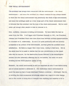
Document - Manuscript, Robin Boyd, The Visual Environment, 1970
Discusses how the architect has broadened the visual perception of environment - from loud and gimmicky (as copied from America) to acceptance and recognition of how to incorporate environmental design into architectural plans.Original manuscript a lecture given at a seminar on the environment conducted in July 1970 by the Institute of Business Administration and the Victorian Employers Federation. The lecture was condensed into two articles published in "The Age" as 'Spoilers of our environment'. The manuscript appears to be Part 1 titled 'Legal vandalism', published in "The Age" on 09.07,1970. Part 2 was titled ' The more optimistic view of the future', published in "The Age" on 10.07.1970 as 'Digger-cult curse'. Typewritten, quarto, 15 pagesenvironment, visual environment, architect, australia, visual pollution, urban ugliness, robin boyd, manuscript -
Bialik College
Plan (item) - Bialik College development, 1980
Architectural plans for Bialik College, 429 Auburn Road, Hawthorn East, created by architects Joshua and Mary Pila, 1980. Please contact [email protected] to request access to this record.1980s -
Moorabbin Air Museum
Archive (Item) - Machine Shop Folder No 3 - Boeing (Gaf / Asta) Collection
Description: Unboxed Folders Machine Shop Planning/Operation Sheets Folder No 2 contains 1/N-10-676 to 1/N-11-496 Level of Importance: National. -
Moorabbin Air Museum
Archive (Item) - Machine Shop Folder No 4 - Boeing (Gaf / Asta) Collection
Description: Unboxed Folders Machine Shop Planning/Operation Sheets Folder No 3 contains 1/N-11-497 to 1/N-11-817 Level of Importance: National. -
 City of Kingston
Pamphlet - Colour, Farrow Falcon Press, Printers, Ozone Estate, Bluff Road, Hampton, c.1940
Sales plan for land in the suburb of Hampton (Highett), bounded by Bluff Road, Wickham Road, Peterson Street and June Street. Includes Morley Street, Follett Avenue, and Parrett StreetThe developing urban area of Highett within the City of Kingston. This land sale pamphlet illustrates the subdivision of land within the municipality and the changing demographic of the district as new houses are constructed close to infrastructure.Colour pamphlet advertising for private sale the Ozone Estate, Bluff Road Hampton. Incorporates a map of the estate bordered by Bluff Road, Wickham Road, June Street and Peterson Street including Morley Street, Follett Avenue and Parrett Street.Handwritten in grey pencil on reverse: Ozone Printed in purple ink on front top right-hand corner: Vendors are - Leslie Harcourt MacGowan, Esq / Neerim Road, Caulfield / & / Arthur Alfred Parrett, Esq / 311 Flinders Lane / Melbourneland sales, estate, hampton, highett