Showing 13828 items
matching tasmanian-built
-
 Bendigo Historical Society Inc.
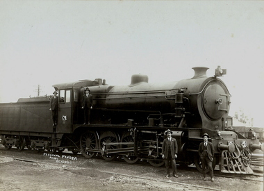
Photograph - C CLASS LOCOMOTIVE NO.2, 1921
Black and white photograph on cream board. Four males C Class locomotive No. 2. Inscriptions: Hand written in image. 'Percival Pinder, Photo, Bendigo, C2'. On back - hand written. '1st Jan, From Jack to Jim, New Year 1970. Left to right, Dave Hyland, Driver, Jack Foley, Fireman, Hayes, Driver front North Melbourne, instructing crews in running C class locomotive. D Dwyer from North Melbourne, Instructing crews in running C class locomotive. C 2 year 1921. First C class ? Built at Newport Workshops 1918. Balance 2 to 26 1921 to 1922. Load 555 ton. One in 50 grade'.Percival Pinder, Bendigocottage, miners -
 Bendigo Historical Society Inc.
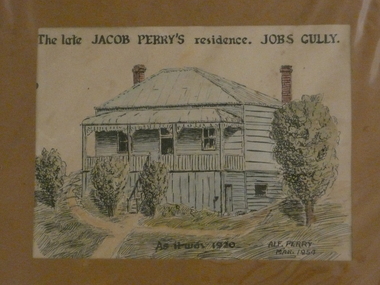
Painting - JACOB PERRY'S RESIDENCE JOBS GULLY
Watercolour and black pen, painted by Alf Perry 1954. Painting shows elevated weather board house, two brick chimneys. Stairs up to front verandah. Written across the top :'The late Jacob Perry's residence. Jobs Gully.Written on bottom of artwork ' As it was 1920, Alf Perry 1954. Written by Alf Perry, in pencil on the back, is the following: ' Drawn from the house in March 1954 but as I knew it in 1920. A verandah is built at the right hand side of the house now. The window below floor level at the right let in light to the little workshop my grandfather used. I used to go up and make (?) little bone knives and forks out of ordinary bones. Alf Perry 1954'.house, private, jacob perry, jobs gully -
 Rutherglen Historical Society
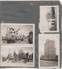
Image, c1939
Small photographs pasted on both sides of a piece of grey cardboard. Written at top of the side with 4 photographs is "Back to Rutherglen 1939". It appears that there were once 5 photos on this side, but number 1 is missing (2017). Documentation identifies them as 1. Jaspers Corner Group 2. Float for parade 3. Fire Brigade cart 4. Unknown shed 5. Silos built 1948. Other side has 5 photographs: 6. General View - Main St looking east 7. General Parade 8. General Parade 9. Fire brigade cart ("Jim Sheridan" written on cardboard next to no. 9) 10. Main St looking east 1949 to 1950back to rutherglen, main street -
 Ballarat Tramway Museum
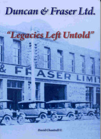
Book, David Chantrell, "Duncan & Fraser Ltd. 'Legacies Left Untold' ", 2008
Provides information about the company and its history that built many of the tram bodies within the BTM collection and photographsBox - 268 pages within blue colour soft covers titled "Duncan & Fraser Ltd. 'Legacies Left Untold' ", written and published by David Chantrell of Adelaide, 2008. Details the story of the coach building firm of Duncan and Fraser of Adelaide who built horse drawn vehicles, horse trams, electric tramcar bodies, motor cars and other vehicles. Tells the story of the company from its founding days, the family and people involved, the conversion to motor car manufacturing and its demise when the Ford Motor car company commenced manufacturing in Geelong. Details known D&F tramcars, provides some lists of existing bodies. Has a copy of the letter that accompanied the book by the authortrams, tramways, duncan fraser, tramcar construction, ford motor company, motor vehicles -
 Kew Historical Society Inc
Plan - Subdivision Plan, Bella Vista Estate, 1929
Pru Sanderson, in her groundbreaking ‘City of Kew Urban Conservation Study : Volume 2 - Development History’ (1988), summarised the periods of urban development and subdivisions of land in Kew. The periods that she identified included 1845-1880, 1880-1893, 1893-1921, 1921-1933, 1933-1943, and Post-War Development. These periods were selected as they represented periods of rapid growth or decline in urban development. An obvious starting point for Sanderson’s groupings involved population growth and the associated economic cycles. These cycles also highlighted urban expansion onto land that was predominantly rural, although in other cases it represented the decline and breakup of large estates. A number of the plans in the Kew Historical Society’s collection can also be found in other collections, such as those of the State Library of Victoria and the Boroondara Library Service. A number are however unique to the collection.The Kew Historical Society collection includes almost 100 subdivision plans pertaining to suburbs of the City of Melbourne. Most of these are of Kew, Kew East or Studley Park, although a smaller number are plans of Camberwell, Deepdene, Balwyn and Hawthorn. It is believed that the majority of the plans were gifted to the Society by persons connected with the real estate firm - J. R. Mathers and McMillan, 136 Cotham Road, Kew. The Plans in the collection are rarely in pristine form, being working plans on which the agent would write notes and record lots sold and the prices of these. The subdivision plans are historically significant examples of the growth of urban Melbourne from the beginning of the 20th Century up until the 1980s. A number of the plans are double-sided and often include a photograph on the reverse. A number of the latter are by noted photographers such as J.E. Barnes.Bella Vista (later ‘Malinda’) was a large Federation house designed by the architect Robert Haddon for Abel Hoadley. The house was built in 1902 and occupied the eastern corner of Thomas Street and Cotham Road. It was a single-storey, red brick house, set back from the road, featuring a central tower topped by a pagoda-like red terra cotta roof, on top of which was perched a very large terra cotta dragon. The Bella Vista subdivision of 1929 included Hoadley’s house as well as nine allotments facing Cotham Road and Alfred and Thomas Streets. In 1941, the land on which Hoadley’s house stood was to be further subdivided. Bella Vista is believed to have lasted until it was demolished in the 1980s.subdivision plans - kew, bella vista estate -
 Royal District Nursing Service (now known as Bolton Clarke)
Photograph - Digital image, c.1930
The name of the Melbourne District Nursing Society (MDNS) After-Care 'Home', changed to 'Hospital' in 1934 and major extensions occurred in 1936.Melbourne District Nursing society (MDNS) opened the After-Care Home, situated at 39 Victoria Parade Collingwood in 1926 following a public appeal for funds. The name changed from MDNS 'Home' to 'Hospital' in 1934. The After-Care Home was originally established to provide nurse-managed convalescent care to poor and underprivileged people who could not look after themselves at home due to illness or on release from hospital. Opening in 1926, at a cost of £27,000, the Home included maternity, children’s and adult wards as well as accommodation for Matron, twelve nurses and four domestic staff. In 1930 an ante-natal clinic was opened at the home. During 1934 the Women’s Welfare Clinic including, at the time, a very controversial Family Planning Clinic, the first of its kind in Australia, was opened to support women at risk following multiple and difficult pregnancies. Major extensions occurred in 1936. Following Government intervention, the After-Care Hospital was separated from the Melbourne District Nursing Society in 1957 and the District division of Melbourne District Nursing Society became the Melbourne District Nursing Service and relocated to 452 St Kilda Road, Melbourne. Following Royal patronage in 1966 this became the Royal District Nursing Service (RDNS). The After-care Hospital continued to operate at the same address in Collingwood until 1985 when it became the Melbourne Geriatric Centre. Black and white digital image taken of the rear of the Melbourne District Nursing Society (MDNS) After-Care Home showing, on the right, part of a three story section of the brick built new wing. Long windows are seen along each storey separated by brick work. Above each window is a wide light strip. Attached to this wing is a narrow three storey section with one long window, with light top strip, shown on each storey. Attached to the left of this are three walkways running to the left of the image. Tall metal handrails run along each walkway. In the background beyond the lowest walkway, part of a hip roof building and a leafy tree can be seen.melbourne district nursing society, after- care hospital, after care home, rdns, royal district nursing service -
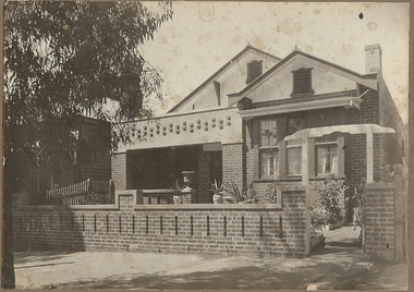 Bendigo Historical Society Inc.
Photograph - T C WATTS & SON COLLECTION: 117 QUEEN STREET,BENDIGO, 1928
BHS CollectionBlack and white photograph mounted on rectangular grey board. House, brick, porch, brick fence, small pane and lead light windows. 1 chimney. Decorative brickwork on verandah lintel and on brick fence. Stained glass windows. Written on back ' tapestry brick fireplace, dining room and kitchen, 117 Queen Street. Brick bungalow, built 1923, 5 rooms, vest, both 2 weatherboard sleep outs, toolshed, woodshed, workshop, garage, sewered. Through to King Street, 33'11 1/4' by 165'. Hot water service, electric copper, 22 points electricity, 8 power points, new gas , stainless ink, crockery cupboards, pedestal basin.t.c. watts & son, 117 queen street bendigo -
 Melbourne Tram Museum
Document - Research Notes, H. S. McComb, "MMTB Tramways Constructed and/or Operated", authorized by statute" and Authorized but not Constructed", 1930 to 1955
Handwritten lists of tramways built, or not constructed listed on full foolscap sheets: .1 - "MMTB Tramways Constructed and/or Operated" - 14 sheets giving street, municipality, extent, whether horse, cable, electric or omnibus with authorisation, date opened and notes. .2 - "Tramways Authorized by Statute" - 24 sheets + 6 unused sheets - listing street, municipality, extent, whether horse, cable, electric, reference to the actual Act and remarks. Includes lines for the Williamstown area. .3 - "MMTB Tramways Authorized but not Constructed" - 2 sheets - giving street, municipality, extent, whether horse, cable, electric or omnibus with authorisation, date opened and notes. Includes a plain sheet of paper giving a trial layout for the form.trams, tramways, mto co, cable trams, parliament, acts of parliament, order in council, regulations, mmtb, tramways, railways, buses, horse trams -
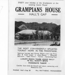 Halls Gap & Grampians Historical Society
Flyer - B/W, C 1931
On Dec.25, 1940 Sylvia Vyanna Morgan passed away. Dorothy had married Roy Warren from Myrtlebank Guest House and Thomas had married Edna Kennedy. In 1942 Nina married Arthur Mangle and in 1946 built Mountain Grand Guest House opposite Grampian House. By 1950 Morgan decided to sell Grampian House and moved to Stawell. The new owners of Grampian House were Fredrick Charles Kingston, a successful bus company operator from Stawell and his daughter Ethel May Mathews who together with her husband Des built the adjoining famous Kookaburra Cafe in 1946. Fredrick had also built a bowling green next to the cafe. In the late 1950's Grampian House Guest House was leased to several people including Mr & Mrs. Hudousek, Paul Loren and people with surname Virtue. It was during this time that the front veranda and pergola were demolished and the house modernised. Nina Mangle and her two sons Arthur & Charles purchased the property and operated it as an overflow for Mountain Grand Guest House. Well known artist Neil Douglas operated a studio on the premises and Horsham identities Evan and Barbara Mackley housed a museum of furniture and artefacts on the site. Advertisement and photo of Grampian House. accommodation, guesthouses, accommodation, grampian house -
 Puffing Billy Railway
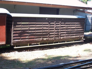
10 NU - Louvred Truck, 30/12/1911
10 NU Louvre Van - Louvred Truck (11) Untrafficable NUU LOUVRED TRUCK. Seven louvre vans for carrying general goods were built during 1899-1901, with another one in 1906 and a further six in 1911, a total of 14 louvre vans numbered 1-14. The term Louvred Truck describes the sides which consist of fixed louvres for ventilation. The aim was to keep the goods inside cool. VR Service History : *NUU 10.VA - 30/12/1911 NWS Built new - / /1926 - To NU 10.VA - NU 10.VA - / 5/1926 - Modified AC Malco /12/1972 BEL To NW 10.VA Sec72/3400, RS72/9371 NW 10.VA - 26/ 8/1976 CLS Photograph #662.2-.4: and end detail 1/10/1977 - Off Register To ETRB Sec76/3630 RS77/4223 Build Date: 30/12/1911 NWS Built new Victorian Heritage Register (VHR) Number H2187 NW 10 is a 1972 reclassification of NU 10. It is presumed the van was used to store tools and equipment. In 1977, the van was removed from railway records and control handed to the Puffing Billy group.Historic - Victorian Railways Narrow Gauge - Rolling Stock - Louvered Van Victorian Heritage Register (VHR) Number H2187 Puffing Billy Locomotives and Rolling Stock CollectionWooden Louvered Van - Made of Timber on a Wrought iron frame - current condition Untrafficable10 NU puffing billy, louvered van, 10nu, victorian railways, 2'6" gauge, narrow gauge rolling stock -
 Eltham District Historical Society Inc
Document, Conveyance of Lot 20 Henry Street, Little Eltham North to Trustees of Wesleyan Chapel, 1856
Originally purchased in 1856 from Thomas Roberts, Yeoman of Little Eltham, for £10 for use by the Wesleyan Chapel, represented by indentured Trustees, Rev. Barnabas Shaw Walker, Minister of the Pentridge Circuit, Francis Thomas, Farmer of Keelbundora, William Harriman, Blacksmith of Nillumbik, Nicholas Rodda, Farmer of Nillumbik, Aaron Grimshaw, Farmer of Greensborough, Joseph Cooper, Gardener of Keelbundora, Peter Dredge, Scholmaster of Jika Jika and Samuel Jeffrey, Farmer of Jika Jika. Lot 20 of Subdivision of Portion 13, Section 4 of the Parish of Nillumbik in the County of Evelyn was located on the southern side of Henry street in Little Eltham North, where the current Our Lady Help of Christians Catholic Church is situated. It became the location of the Eltham Rechabite Hall. In 1893 a new hall was built and further enlarged in 1919. At the commencement of 1922, the property was purchased from the Independent Order of Rechabites with publicly subscribed funds and a new hall built at a cost of £750 and improved road access constructed to reduce the grade, running from Dudley Street to Henry Street. This hall was eventually replaced with the new Shire Offices and Hall built on the corner of Arthur Street and Main Road, which was opened in 1941. Traces the earliest history of the Eltham Public Hall in Henry Street and the various names, occupations and abodes of the Trustees associated with the propertyaaron grimshaw, blacksmith, edmond perry, eltham public hall, eltham rechabite hall, eltham wesleyan chapel, francis thomas, george smith, henry street, i.w. lucas, james blanch, james chapman, james william brown, john jenkins peacock, john jones, john neale, john van mangerhoussen weiss, joseph cooper, joseph morris holloway, josiah atwool, keelbundora, lancelot iredale, little eltham, lizar elliott, mark blanchard, methodist church, nicholas rodda, p. mather, peter dredge, rev barnabas shaw walker, samuel jeffrey, samuel moor munce, thomas roberts, thomas wheaten bowden, william harriman, william hebblewhite, william john munce, william matthews, william rose -
 Kew Historical Society Inc
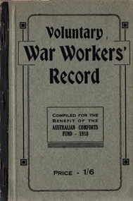
Booklet, Australian Comforts Fund (Victorian Divsion), Voluntary War Workers Record, 1918
The Australian Comforts Fund was established in August 1916 to co-ordinate the activities of the state based patriotic funds, which were established earlier in World War I. Mainly run by women, they provided and distributed free comforts to the Australian 'fit' fighting men in all the battle zones. They became divisions of the Australian Comforts Fund. The Council of the Fund comprised two delegates from New South Wales, Victoria and Queensland and one from the states of Western Australia, South Australia and Tasmania. The Executive headquarters was located in Sydney. It ceased operation on 10 April 1920 and was reconstituted in World War II in June 1940 and ceased operation again on 27 June 1946. The state bodies in World War I were: New South Wales: the 'Citizens' 'War Chest' Fund; Queensland Patriotic Fund; South Australia: League of Loyal Women; Tasmania: 'On Active Service Fund'; Australian Comforts Fund, Victorian Division; Victoria League of Western Australia. During World War II the state bodies were called : The Lord Mayor's Patriotic and War Fund of New South Wales; the Australian Comforts Fund, Victorian Division; the Australian Comforts Fund, Queensland Division; the Australian Comforts Fund, Tasmanian Division; the Fighting Forces Comforts Fund SA Inc; the Victoria League Camp Comforts Fund ( W A ) Australian Comforts Fund commissioners conducted its activities in the field, holding honorary rank as officers of the Army or Air Force.World War 1 publication for the home front with Kew listingsVoluntary War Workers Record, compiled for the benefit of the Australian Comforts Fund - 1918. Price - 1/6. the publication includes sections on Kew.australian comforts fund, australian comforts fund (victoria) -
 Kew Historical Society Inc
Plan, Melbourne & Metropolitan Board of Works : Borough of Kew : Detail Plan No.1563, 1905
The Melbourne and Metropolitan Board of Works (MMBW) plans were produced from the 1890s to the 1950s. They were crucial to the design and development of Melbourne's sewerage and drainage system. The plans, at a scale of 40 feet to 1 inch (1:480), provide a detailed historical record of Melbourne streetscapes and environmental features. Each plan covers one or two street blocks (roughly six streets), showing details of buildings, including garden layouts and ownership boundaries, and features such as laneways, drains, bridges, parks, municipal boundaries and other prominent landmarks as they existed at the time each plan was produced. (Source: State Library of Victoria)This plan forms part of a large group of MMBW plans and maps that was donated to the Society by the Mr Poulter, City Engineer of the City of Kew in 1989. Within this collection, thirty-five hand-coloured plans, backed with linen, are of statewide significance as they include annotations that provide details of construction materials used in buildings in the first decade of the 20th century as well as additional information about land ownership and usage. The copies in the Public Record Office Victoria and the State Library of Victoria are monochrome versions which do not denote building materials so that the maps in this collection are invaluable and unique tools for researchers and heritage consultants. A number of the plans are not held in the collection of the State Library of Victoria so they have the additional attribute of rarity.Original survey plan, issued by the MMBW to a contractor with responsibility for constructing sewers in the area identified on the plan within the Borough of Kew. The plan was at some stage hand-coloured, possibly by the contractor, but more likely by officers working in the Engineering Department of the Borough and later Town, then City of Kew. The hand-coloured sections of buildings on the plan were used to denote masonry or brick constructions (pink), weatherboard constructions (yellow), and public buildings (grey). This plan covers the area between Barkers Road, Wrixon Street, Sackville Street and Brougham Place, much of it now occupied by Carey Baptist Grammar and Preshil schools. This was an area of large and prestigious homes in 1903, some with formally laid-out gardens, such as ‘Tower Hill’ and ‘Opawa’. ‘Kalimna’ was built in 1890-91 for William H. Jarman, an accountant, and ‘Blackhall’ at the same time for W.H. Roberts. Blackhall was to be acquired by the Salvation Army in 1915 and renamed ‘Catherine Booth Girls’ Home’. The Home accommodated girls, aged between 4 and 16. Kalimna and Blackhall are of significance as typical and intact late Victorian mansions and as such are two key Victorian buildings to have been built in Kew. Both Blackhall and Kalimna are now part of Preshil. ‘Fairview’ was for a long time occupied by the Sisters of St. Joseph of Cluny as a care home for the elderly, but it is now part of Carey Grammar School, as are the grounds of ‘Wagga Merne’, ‘Weemutta’, ‘Blakely’, ‘Daheim’ and ‘Mildura’ (later ‘Urangeline’), the last being particularly impressive in 1903, with a tennis court, conservatory, outhouses, and two bathrooms!melbourne and metropolitan board of works, detail plans, mmbw 1563, cartography -
 Kew Historical Society Inc
Plan, Melbourne & Metropolitan Board of Works : Borough of Kew : Detail Plan No.1574, 1905
The Melbourne and Metropolitan Board of Works (MMBW) plans were produced from the 1890s to the 1950s. They were crucial to the design and development of Melbourne's sewerage and drainage system. The plans, at a scale of 40 feet to 1 inch (1:480), provide a detailed historical record of Melbourne streetscapes and environmental features. Each plan covers one or two street blocks (roughly six streets), showing details of buildings, including garden layouts and ownership boundaries, and features such as laneways, drains, bridges, parks, municipal boundaries and other prominent landmarks as they existed at the time each plan was produced. (Source: State Library of Victoria)This plan forms part of a large group of MMBW plans and maps that was donated to the Society by the Mr Poulter, City Engineer of the City of Kew in 1989. Within this collection, thirty-five hand-coloured plans, backed with linen, are of statewide significance as they include annotations that provide details of construction materials used in buildings in the first decade of the 20th century as well as additional information about land ownership and usage. The copies in the Public Record Office Victoria and the State Library of Victoria are monochrome versions which do not denote building materials so that the maps in this collection are invaluable and unique tools for researchers and heritage consultants. A number of the plans are not held in the collection of the State Library of Victoria so they have the additional attribute of rarity.Original survey plan, issued by the MMBW to a contractor with responsibility for constructing sewers in the area identified on the plan within the Borough of Kew. The plan was at some stage hand-coloured, possibly by the contractor, but more likely by officers working in the Engineering Department of the Borough and later Town, then City of Kew. The hand-coloured sections of buildings on the plan were used to denote masonry or brick constructions (pink), weatherboard constructions (yellow), and public buildings (grey). This plan shows several very large houses, particularly along Glenferrie Road, and the area now occupied by Ruyton Girls’ School. ‘Tarring’ (incorrectly spelled here as ‘Karring’) was built for Henry Henty in 1872, on part of his original allotment of 20 acres, and ‘Mount View’, which retains its original building and the fountain in the front garden, is part of Ruyton’s Junior School. The most significant change to Tarring and its grounds since 1903, involve the removal of a number of the outbuildings, including a Burmese temple, bought by Henty from the Burmese Exhibit at the Great Exhibition of 1880. It is shown on the plan as a summerhouse. The two-storey mansion, on the corner of Glenferrie Road and Wellington Street, was built in 1891 by leading architect Alfred White as his own home. Having an initial N.A.V. of £160, the house was purchased by a warehouseman Henry Lister, by 1900, when the N.A.V. was recorded at £111. By the turn of the century the house was known as ‘Comaques’. By contrast, much smaller houses are shown in Scott and Byron Streets, including a tiny Mission Hall in Byron Street, which belonged to the Anglican Church from at least 1903 to 1917.melbourne and metropolitan board of works, detail plans, maps - borough of kew, mmbw 1574, cartography -
 Bendigo Historical Society Inc.
Map - Laminated map of Lake Eppalock at full capacity
John Perry Collection. Laminated copy of map of Lake Eppalock at full capacity. Had highlighter markings of old roads which appear to be still in use. The dam was built by the State Rivers and Water Supply Commission of Victoria. The dam wall height is 45 metres (148 ft) and the main embankment is 1,041 metres (3,415 ft) long. At 100% capacity the dam wall was designed to hold back 304,651 megalitres (6.7014×10¹⁰ imp gal; 8.0480×10¹⁰ US gal) of water. The surface area of Lake Eppalock is 3,011 hectares (7,440 acres) and the catchment area is 2,124 square kilometres (820 sq mi). The controlled spillway is capable of discharging 8,040 cubic metres per second (284,000 cu ft/s). Lake Eppalock supplies both stock and domestic water to the Campaspe irrigation district. It also serves as a water supply to Bendigo and Heathcote and, in more recent times, Ballarat. The lake is a major attraction for those engaging in watersports, with a number of tourist parks and accommodation facilities available. Permissible activities on the lake include high-speed boating, water skiing, sailing, canoeing, fishing and swimming. The lake's water levels were low for approximately eight years between 2002 and 2010 during a prolonged drought, which restricted the amount of recreational activity until rainfall in the latter half of 2010 returned the lake to 100 percent capacity. Built between 1961 and 1964, Lake Eppalock remains the only water storage on the Campaspe River system.map, water, dam, reservoir, eppalock -
 Bendigo Historical Society Inc.
Map - Laminated worksheet - identification of inundated artifacts at Lake Eppalock
John Perry Collection. Laminated copy of worksheet identifying inundated artifacts at Lake Eppalock when at 10% capacity. The dam was built by the State Rivers and Water Supply Commission of Victoria. The dam wall height is 45 metres (148 ft) and the main embankment is 1,041 metres (3,415 ft) long. At 100% capacity the dam wall was designed to hold back 304,651 megalitres (6.7014×10¹⁰ imp gal; 8.0480×10¹⁰ US gal) of water. The surface area of Lake Eppalock is 3,011 hectares (7,440 acres) and the catchment area is 2,124 square kilometres (820 sq mi). The controlled spillway is capable of discharging 8,040 cubic metres per second (284,000 cu ft/s). Lake Eppalock supplies both stock and domestic water to the Campaspe irrigation district. It also serves as a water supply to Bendigo and Heathcote and, in more recent times, Ballarat. The lake is a major attraction for those engaging in watersports, with a number of tourist parks and accommodation facilities available. Permissible activities on the lake include high-speed boating, water skiing, sailing, canoeing, fishing and swimming. The lake's water levels were low for approximately eight years between 2002 and 2010 during a prolonged drought, which restricted the amount of recreational activity until rainfall in the latter half of 2010 returned the lake to 100 percent capacity. Built between 1961 and 1964, Lake Eppalock remains the only water storage on the Campaspe River system.map, artifacts, eppalock, reservoir -
 Bendigo Historical Society Inc.
Map - Black and white map pertaining to Lake Eppalock
John Perry Collection. Laminated copy of map pertaining to Lake Eppalock. Gives details of dwellings, bridges and ford crossings. The dam was built by the State Rivers and Water Supply Commission of Victoria. The dam wall height is 45 metres (148 ft) and the main embankment is 1,041 metres (3,415 ft) long. At 100% capacity the dam wall was designed to hold back 304,651 megalitres (6.7014×10¹⁰ imp gal; 8.0480×10¹⁰ US gal) of water. The surface area of Lake Eppalock is 3,011 hectares (7,440 acres) and the catchment area is 2,124 square kilometres (820 sq mi). The controlled spillway is capable of discharging 8,040 cubic metres per second (284,000 cu ft/s). Lake Eppalock supplies both stock and domestic water to the Campaspe irrigation district. It also serves as a water supply to Bendigo and Heathcote and, in more recent times, Ballarat. The lake is a major attraction for those engaging in watersports, with a number of tourist parks and accommodation facilities available. Permissible activities on the lake include high-speed boating, water skiing, sailing, canoeing, fishing and swimming. The lake's water levels were low for approximately eight years between 2002 and 2010 during a prolonged drought, which restricted the amount of recreational activity until rainfall in the latter half of 2010 returned the lake to 100 percent capacity. Built between 1961 and 1964, Lake Eppalock remains the only water storage on the Campaspe River system.eppalock, map, water, dam, reservoir -
 Bendigo Historical Society Inc.
Map - Map of overlay of lake Eppalock at full capacity. Map 'C'
John Perry collection. Map 'C'. Laminated map of overlay of Lake Eppalock at full capacity. Circa 1951. The dam was built by the State Rivers and Water Supply Commission of Victoria. The dam wall height is 45 metres (148 ft) and the main embankment is 1,041 metres (3,415 ft) long. At 100% capacity the dam wall was designed to hold back 304,651 megalitres (6.7014×10¹⁰ imp gal; 8.0480×10¹⁰ US gal) of water. The surface area of Lake Eppalock is 3,011 hectares (7,440 acres) and the catchment area is 2,124 square kilometres (820 sq mi). The controlled spillway is capable of discharging 8,040 cubic metres per second (284,000 cu ft/s). Lake Eppalock supplies both stock and domestic water to the Campaspe irrigation district. It also serves as a water supply to Bendigo and Heathcote and, in more recent times, Ballarat. The lake is a major attraction for those engaging in watersports, with a number of tourist parks and accommodation facilities available. Permissible activities on the lake include high-speed boating, water skiing, sailing, canoeing, fishing and swimming. The lake's water levels were low for approximately eight years between 2002 and 2010 during a prolonged drought, which restricted the amount of recreational activity until rainfall in the latter half of 2010 returned the lake to 100 percent capacity. Built between 1961 and 1964, Lake Eppalock remains the only water storage on the Campaspe River system.map, water, eppalock, dam, reservoir -
 Bendigo Historical Society Inc.
Map - Laminated map of Lake Eppalock empty. Map 'D'
John Perry Collection. Laminated map of Lake Eppalock empty. Map 'D'. Circa 1951. The dam was built by the State Rivers and Water Supply Commission of Victoria. The dam wall height is 45 metres (148 ft) and the main embankment is 1,041 metres (3,415 ft) long. At 100% capacity the dam wall was designed to hold back 304,651 megalitres (6.7014×10¹⁰ imp gal; 8.0480×10¹⁰ US gal) of water. The surface area of Lake Eppalock is 3,011 hectares (7,440 acres) and the catchment area is 2,124 square kilometres (820 sq mi). The controlled spillway is capable of discharging 8,040 cubic metres per second (284,000 cu ft/s). Lake Eppalock supplies both stock and domestic water to the Campaspe irrigation district. It also serves as a water supply to Bendigo and Heathcote and, in more recent times, Ballarat. The lake is a major attraction for those engaging in watersports, with a number of tourist parks and accommodation facilities available. Permissible activities on the lake include high-speed boating, water skiing, sailing, canoeing, fishing and swimming. The lake's water levels were low for approximately eight years between 2002 and 2010 during a prolonged drought, which restricted the amount of recreational activity until rainfall in the latter half of 2010 returned the lake to 100 percent capacity. Built between 1961 and 1964, Lake Eppalock remains the only water storage on the Campaspe River system.map, water, dam, reservoir, eppalock -
 Bendigo Historical Society Inc.
Document - Legend to maps A, B and C for Lake Eppalock
John Perry Collection. Laminated 'legend' for Maps A, B and C for Lake Eppalock also in this collection. Black and White definitions and descriptions of objects and markers found on maps. Circa 1951. The dam was built by the State Rivers and Water Supply Commission of Victoria. The dam wall height is 45 metres (148 ft) and the main embankment is 1,041 metres (3,415 ft) long. At 100% capacity the dam wall was designed to hold back 304,651 megalitres (6.7014×10¹⁰ imp gal; 8.0480×10¹⁰ US gal) of water. The surface area of Lake Eppalock is 3,011 hectares (7,440 acres) and the catchment area is 2,124 square kilometres (820 sq mi). The controlled spillway is capable of discharging 8,040 cubic metres per second (284,000 cu ft/s). Lake Eppalock supplies both stock and domestic water to the Campaspe irrigation district. It also serves as a water supply to Bendigo and Heathcote and, in more recent times, Ballarat. The lake is a major attraction for those engaging in watersports, with a number of tourist parks and accommodation facilities available. Permissible activities on the lake include high-speed boating, water skiing, sailing, canoeing, fishing and swimming. The lake's water levels were low for approximately eight years between 2002 and 2010 during a prolonged drought, which restricted the amount of recreational activity until rainfall in the latter half of 2010 returned the lake to 100 percent capacity. Built between 1961 and 1964, Lake Eppalock remains the only water storage on the Campaspe River system.map, water, dam, reservoir, eppalock -
 Bendigo Historical Society Inc.
Document - Collection of photographs from newspaper on a single page
John Perry Collection. Laminated copy of page from 'Weekly Times' newspaper, February, 1962. Nine images relating to establishing and building Eppalock Reservoir, 15 miles from Bendigo. The dam was built by the State Rivers and Water Supply Commission of Victoria. The dam wall height is 45 metres (148 ft) and the main embankment is 1,041 metres (3,415 ft) long. At 100% capacity the dam wall was designed to hold back 304,651 megalitres (6.7014×10¹⁰ imp gal; 8.0480×10¹⁰ US gal) of water. The surface area of Lake Eppalock is 3,011 hectares (7,440 acres) and the catchment area is 2,124 square kilometres (820 sq mi). The controlled spillway is capable of discharging 8,040 cubic metres per second (284,000 cu ft/s). Lake Eppalock supplies both stock and domestic water to the Campaspe irrigation district. It also serves as a water supply to Bendigo and Heathcote and, in more recent times, Ballarat. The lake is a major attraction for those engaging in watersports, with a number of tourist parks and accommodation facilities available. Permissible activities on the lake include high-speed boating, water skiing, sailing, canoeing, fishing and swimming. The lake's water levels were low for approximately eight years between 2002 and 2010 during a prolonged drought, which restricted the amount of recreational activity until rainfall in the latter half of 2010 returned the lake to 100 percent capacity. Built between 1961 and 1964, Lake Eppalock remains the only water storage on the Campaspe River system. dam, engineering, water, eppalock -
 Bendigo Historical Society Inc.
Map - Black and White map. Outline of Lake Eppalock. Map 'B'
John Perry Collection. Laminated copy black and white map. Map 'B'. Outline of Lake Eppalcok, overlayed on map. Circa 1951. The dam was built by the State Rivers and Water Supply Commission of Victoria. The dam wall height is 45 metres (148 ft) and the main embankment is 1,041 metres (3,415 ft) long. At 100% capacity the dam wall was designed to hold back 304,651 megalitres (6.7014×10¹⁰ imp gal; 8.0480×10¹⁰ US gal) of water. The surface area of Lake Eppalock is 3,011 hectares (7,440 acres) and the catchment area is 2,124 square kilometres (820 sq mi). The controlled spillway is capable of discharging 8,040 cubic metres per second (284,000 cu ft/s). Lake Eppalock supplies both stock and domestic water to the Campaspe irrigation district. It also serves as a water supply to Bendigo and Heathcote and, in more recent times, Ballarat. The lake is a major attraction for those engaging in watersports, with a number of tourist parks and accommodation facilities available. Permissible activities on the lake include high-speed boating, water skiing, sailing, canoeing, fishing and swimming. The lake's water levels were low for approximately eight years between 2002 and 2010 during a prolonged drought, which restricted the amount of recreational activity until rainfall in the latter half of 2010 returned the lake to 100 percent capacity. Built between 1961 and 1964, Lake Eppalock remains the only water storage on the Campaspe River system.map, water, dam, reservoir, eppalock -
 Bendigo Historical Society Inc.
Map - Black and white map pertaining to Lake Eppalock
John Perry Collection. Laminated copy of map relating to Lake Eppalock. Lists dwellings, ford crossings and bridges. The dam was built by the State Rivers and Water Supply Commission of Victoria. The dam wall height is 45 metres (148 ft) and the main embankment is 1,041 metres (3,415 ft) long. At 100% capacity the dam wall was designed to hold back 304,651 megalitres (6.7014×10¹⁰ imp gal; 8.0480×10¹⁰ US gal) of water. The surface area of Lake Eppalock is 3,011 hectares (7,440 acres) and the catchment area is 2,124 square kilometres (820 sq mi). The controlled spillway is capable of discharging 8,040 cubic metres per second (284,000 cu ft/s). Lake Eppalock supplies both stock and domestic water to the Campaspe irrigation district. It also serves as a water supply to Bendigo and Heathcote and, in more recent times, Ballarat. The lake is a major attraction for those engaging in watersports, with a number of tourist parks and accommodation facilities available. Permissible activities on the lake include high-speed boating, water skiing, sailing, canoeing, fishing and swimming. The lake's water levels were low for approximately eight years between 2002 and 2010 during a prolonged drought, which restricted the amount of recreational activity until rainfall in the latter half of 2010 returned the lake to 100 percent capacity. Built between 1961 and 1964, Lake Eppalock remains the only water storage on the Campaspe River system.map, water, dam, reservoir, eppalock -
 Bendigo Historical Society Inc.
Map - General view of area of proposed construction of Lake Eppalock. Map 'A'
John Perry Collection. Laminated map of proposed construction of Lake Eppalock. Map 'A'. Black and white map in laminate. Circa 1951. The dam was built by the State Rivers and Water Supply Commission of Victoria. The dam wall height is 45 metres (148 ft) and the main embankment is 1,041 metres (3,415 ft) long. At 100% capacity the dam wall was designed to hold back 304,651 megalitres (6.7014×10¹⁰ imp gal; 8.0480×10¹⁰ US gal) of water. The surface area of Lake Eppalock is 3,011 hectares (7,440 acres) and the catchment area is 2,124 square kilometres (820 sq mi). The controlled spillway is capable of discharging 8,040 cubic metres per second (284,000 cu ft/s). Lake Eppalock supplies both stock and domestic water to the Campaspe irrigation district. It also serves as a water supply to Bendigo and Heathcote and, in more recent times, Ballarat. The lake is a major attraction for those engaging in watersports, with a number of tourist parks and accommodation facilities available. Permissible activities on the lake include high-speed boating, water skiing, sailing, canoeing, fishing and swimming. The lake's water levels were low for approximately eight years between 2002 and 2010 during a prolonged drought, which restricted the amount of recreational activity until rainfall in the latter half of 2010 returned the lake to 100 percent capacity. Built between 1961 and 1964, Lake Eppalock remains the only water storage on the Campaspe River system.map, dam, water, weir, eppalock -
 Orbost & District Historical Society
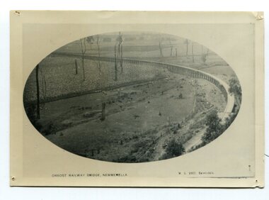
black and white photograph, Vogt. W.S, first half 20th century
In 1912 work was underrway on the Bairnsdale to Orbost railway. It was opened on April 10 1916. The two bridges on the railway viaduct, which crosses the Snowy River floodplain at Orbost, were built from local Southern Mahogany. The bridge on the Bairnsdale end (770m) is now the longest in Victoria. (info. Helen Martin)This item is associated with the history of the Orbost-Bairnsdale railway line and therefore reflects the role that the rail line played in the social and economic history of Orbost.A black / white photograph, oval-shaped on white background. It is of the railway viaduct across the flats at Orbost,.photo caption -"ORBOST RAILWAY BRIDGE, NEWMERELLA E. S. Vogt, Bairnsdale"newmerella orbost-viaduct east-gipsland-railway -
 Eltham District Historical Society Inc
Document - Building Plan, J.M. Harcourt, 22 Peter Street, Eltham, c.1946
Pise or Adobe Brick Cottage for Mr D. Sawer in Peter St., Eltham Design and drawings by J.M. Harcourt, Clay Nuneham, Eltham. The cottage at present day 22 Peter Street was built circa 1946. Also Drawing of planned carport and future extension for 22 Peter Street, Eltham22 peter street, building plans, clay nuneham, d. sawer, eltham, j.m. harcourt design, adobe house, j.m. harcourt designc.1946, pise house -
 Eltham District Historical Society Inc
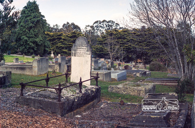
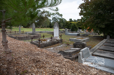
Negative - Photograph, Harry Gilham, Grave of Harriet Agrita Falkiner (1849-1923) , Eltham Cemetery, Victoria, Sep 2009
Harriet Falkiner was the daughter of Frederick Edward and Fanny Falkiner. Frederick was Eltham's first postmaster and settled in the district on the Diamond Creek and Yarra River around 1848 where he established an orchard and grazed cattle. The original family home was a pioneer settler's cottage built by Frederick Falkiner in Ely street.Roll of 35mm colour negative film, 6 stripsKodak GC 400-9alexander richard falkiner, eltham cemetery, evelyn falkiner, frederick edward falkiner, gravestones, harriet agrita falkiner -
 Eltham District Historical Society Inc
Photograph, Peter Pidgeon, Grave of Harriet Agrita Falkiner (1849-1923) , Eltham Cemetery, Victoria, 5 April 2021
Harriet Falkiner was the daughter of Frederick Edward and Fanny Falkiner. Frederick was Eltham's first postmaster and settled in the district on the Diamond Creek and Yarra River around 1848 where he established an orchard and grazed cattle. The original family home was a pioneer settler's cottage built by Frederick Falkiner in Ely street.Born Digitaleltham cemetery, gravestones, heritage excursion, alexander richard falkiner, evelyn falkiner, frederick edward falkiner, harriet agrita falkiner -
 Bendigo Military Museum
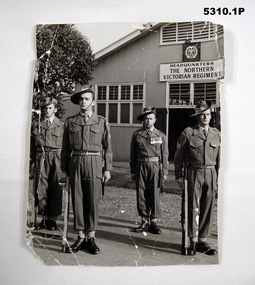
Photograph - PHOTOGRAPHS OF SOLDIERS, 38th BATTALION, 38 Bn, c1950-1962
38 Bn was raised in Bendigo in 1916. Post War it was the CMF Unit until 1967. The Mollison St Drill Hall was built by Contractor Mr. Midgley. First used Jan 1916. Shut down Circa 2002. The 38 Bn Colours are held within the RSL Military Museum, Bendigo.1. Photo of 4 Senior NCO's in battle dress in front of the Mollison Street Drill Hall. 38 Bn Northern Victorian Regiment. The four soldiers have .303 rifles. WO Burrell has the red sash of a Colour Sgt. His MM can be seen. 2. Photo of Regiment Colours 38 Northern Vic Regiment in front of Mollison St Drill Hall. Two Officers, Capt. Emonde holding Queens Colours - 4 Snr NCO's have rifles at the slope with ceremonial tips on their bayonets.1. On rear is written - Cenotaph party/ Warrant Officer 3 sets Guards. 2. On rear is written - '" ANZAC DAY" .38 bn, mollison st, drill hall, photographs -
 Federation University Historical Collection
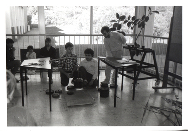
Photograph - Black and White Photograph, Ballarat Institute of Advanced Education Students Engaged in Structural Work on Open Day, 1989, c1974
.1 & .2 - Civil Engineering student practical work examples .3 - First year Engineering students' competition : design, built and tested specified braced truss. Testing usually done during Open Day. .4 - Thermodynamics laboratory colorimetry room. reproduced in the 1975 Handbook, p 90Images of students engaged in structural work. .1) Three people at a load frame with a roof tress element. .2) A male student at an electronic surveying instrument. .3) Several people around a test setup for a student made model truss. .4) Three male persons at an experimental setup involving a garbage bin.ballarat institute of advanced education, civil engineering, laboratory, open day, thermodynamics, lloyd payne, alumni, trevor gourley