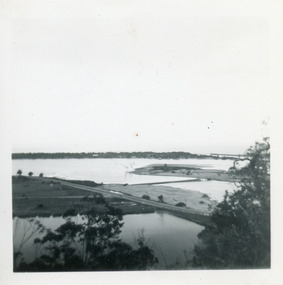
Showing 14048 items matching "snowy-river-bridge"
-
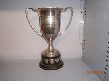 Wangaratta High School
WHS Trophy- Sport, 1931-1967
Gold metal elongated cup trophy with a brown plastic base and silver metal shields attached to the bottom. Engraved in the cup is:N.E.D.S.S.S.A. Football Premiership Donated by BROKEN RIVER HURIER ________ Benella -
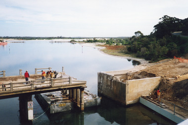
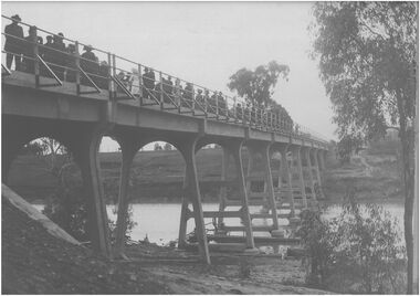
 Glenelg Shire Council Cultural Collection
Photograph - Photograph - Bridge Construction, n.d
Port of Portland Authority ArchivesFront: Back- Purple CSIRO stampport of portland archives -
 Lakes Entrance Historical Society
Photograph - Old North Arm Bridge, 2000
Date made May 2000Colour photograph showing the activity during the deconstruction of the old North Arm bridge showing cranes lifting handrails, circular saw cutting concrete bridge decking, and top of piers removed. Scene indicates how the bridge was constructed in 1917. Lakes Entrance Victoriabridges, waterways, demolition -
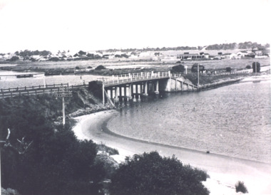
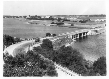 Lakes Entrance Historical Society
Photograph - North Arm bridge Lakes Entrance Victoria, 1935c
Black and white photograph of view of concrete North Arm Bridge, showing highway to town, Cunninghame Arm, sand hummocks, vegetation, touring car approaching bridge, and three cars parked at town end of bridge, electricity and telegraph poles. Lakes Entrance Victoriatownship, vegetation, transport, bridges -
 Eltham District Historical Society Inc
Photograph, Floodwaters, Diamond Creek, Eltham, 1934
The Diamond Creek in flood near the Main Road bridge at Eltham, Victoria. The Yarra also was in flood. In early December 1934 the "Greatest flood in the history of the Yarra" occured, according to The Argus newspaper. Bridges and houses were swept away with hundreds of people left homeless across the state. The historic 1934 flood of the Diamond Creek and Yarra River set the criteria for future planning with respect to flood water rise.This photo forms part of a collection of photographs gathered by the Shire of Eltham for their centenary project book, "Pioneers and Painters: 100 years of the Shire of Eltham" by Alan Marshall (1971). The collection of over 500 images is held in partnership between Eltham District Historical Society and Yarra Plenty Regional Library (Eltham Library) and is now formally known as 'The Shire of Eltham Pioneers Photograph Collection.' It is significant in being the first community sourced collection representing the places and people of the Shire's first one hundred years.Digital image 4 x 5 inch B&W Neg (2 frames on one neg) 9 x 15.5 cm B&W printflooding, eltham, shire of eltham pioneers photograph collection, sepp, diamond creek (river), floods, 1934 flood, diamond creek -
 Melbourne Legacy
Slide, Operation Float 1957, 1957
A colour slide small boats on the Yarra River or Port Philip alongside larger moored boats in 1957. Operation Float was an event run by Melbourne Legacy to take Junior legatees on an outing. It could have been to naval boats such as HMAS Cerberus or to a Yacht club. It gave the junior legatees the opportunity to see a naval boat in action, spend time on the water or try sailing. In 1957 it appears to be several smaller boats taking small groups of children out on the bay. Was with many other slides taken in the 1950s and 1960s. The slides have been photographed to make digital images and moved to archive quality sleeves. In many cases the original images were not well focussed and the digital image the best available.A record of outings being organised for children.Colour slide of small boats on the Yarra or bay in a red edged Kodachrome cardboard mount.Printed on reverse in red ink 'Kodachrome Transparency / Processed by Kodak'. Handwritten in blue ink 'Heading up river / 22 / 1957'. Imprinted in black ink '19'operation float, junior legatee outings -
 Lakes Entrance Historical Society
Photograph - Bullock Island, Fraser Ian, 1920c
Black and white photograph of Bullock Island, showing Prince's Highway from North Arm bridge, east end of Bullock Island and bridge, entrance to Bass Strait and sand dunes along Cunninghame Arm. Western end of Bullock Island bridge raised to allow small boats access to North Arm and Cunninghame Arm, became known as Humpy Bridge. Lakes Entrance Victoria islands, waterways, topography, bridges -
 Whitehorse Historical Society Inc.
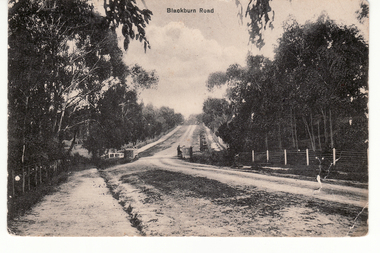
Postcard - Black and white postcard, Blackburn Road Circa 1908, C1914
Black and white postcard entitled 'Blackburn Road'. Scene shows bridge over unmade road and heavily treed sides. Looking north|Known as Halley's Bridge.|Demolished in 1965.|Blue stones from bridge used in garden of Lynette Letcher in Clovely Court Blackburn.blackburn road, blackburn, hooke, albert arthur, halley's bridge, bridges, letcher lynette -
 Orbost & District Historical Society
black and white photograph, January 1934
Orbost has been subject to major floods throughout its history, such as those which left the town isolated in 1934, 1952, 1971 and 1978. It is recorded that the Snowy River broke its banks and flooded the flats 104 times between 1884 and 1978. Extensive flooding in Eastern Victoria during June 1978, caused widespread damage to roads, road closures and hazards to traffic, particularly over the Queen's Birthday holiday weekend.This is a pictorial record of a significant event in Orbost's history.A very faded black / white photograph of flood water under the railway viaduct at watt's Gulch.orbost-flood-1934 railway-viaduct-orbost -
 Orbost & District Historical Society
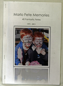
magazine, Marlo Primary School, Marlo Fete Memories 40 Fantastic Fetes 1971 -2011, 2011
The history of Marlo dates back to the days when ships voyaged between Melbourne and Lakes Entrance. Attempts were made to use the Snowy River for trading purposes but the bar at Marlo proved too dangerous. The school opened on 3rd of July 1903 with the HT Walter Scott. At present Marlo is noted for fishing and tourism. The fete, held each Easter, is a major fundraiser for the school and all money goes towards sustaining the schools Music ProgramThe Marlo Fete is a significant yearly event in the local community. This book celebrates that. It is a useful research tool.A stapled 31 pp A4 sized booklet produced to celebrate 40 years of the Marlo Fete which is held annually at Easter at Marlo Primary School. It contains photographs, history and recipes. On the white front cover below the title (black text) is a coloured photograph of two young boys with faces painted and holding fairy floss.marlo marlo-primary-school celebrations fetes -
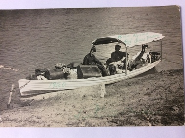 Port of Echuca
Postcard, February 1920
This is a photograph of three men in a heavily laden boat. The boat is tied up to a stick inserted into the bank. There is a black cocker spaniel dog also in the boat. The man in the middle back is believed to be John Trestrail Freeman. The card has been addressed to his wife. Dolly Freeman née Dolly Dean. The other two men , Bot and Paddy cannot be identified. The men are obviously travelling up the river. There is a motor on the back of the boat. The luggage includes a Gladstone bag, suit cases and boxes, indicating they have been travelling a long distance.This photograph is significant because it shows the type of transport available in the 1920's. Also it shows the conditions the three men travelled in. The boat was small, heavily laden with a simple motor. River traffic in 1920 would have been sparse. Also a journey from Echuca to Mildura would have taken weeks to complete.A rectangular black and white postcard showing three men and a dog in a heavily laden boat, which is tied up to the bank.On the back is printed W. GRIMWOOD/ POSTCARD/CORRESPONDENCE/ ADDRESS ONLY/KODAK AUSTRALIA . Handwritten in ink on the back are the words "To Doll from Bot, Tress, Paddy, River Rovers on Trip to Mildura Feb. 1920." Written on the front of the card in green ball point ink are the words "River Rovers Bot Tress Paddy 1920". In the bottom right hand corner in green pen is written "Echuca to Mildura. Tress Freeman."freeman, john trestrail (jr.), mildura, murray river, river rovers, freeman, dolly -
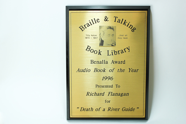 Vision Australia
Photograph - Image, Benalla Award Audio Book of the Year 1996
This award was presented at an award night hosted by the Braille and Talking Book Library to Richard Flanagan for "Death of a River Guide". As Richard Flanagan did not receive his award on the night the Braille and Talking Book Library kept it for him, however it was not collected. To encourage the development of audio books, a series of awards were established by the National Library of Australia in 1988, and sponsored by TDK from 1991 until their demise in 2000. Open to both commercial and non-commercial publishers, it aimed to recognise the quality achievements by individuals and publishing houses and to promote the inclusion of audio books into the mainstream market.Wooden rectangle with metal plate inscribed with winners nameBraille and Talking Book Library Tilly Aston 1873 - 1947 ... that all may read Benalla Award Audio Book of the Year 1996 Presented to Richard Flanagan for "Death of a River Guide"awards, audio books -
Glenelg Shire Council Cultural Collection
Negative - Negative - Glenelg River near Nelson, Victoria, c. 1936
Negative for a black and white photograph. Image shows Glenelg River near Nelson, Victoria. Dinghy pulled up on river bank, jetty bottom left, group of people on bank beneath trees. -
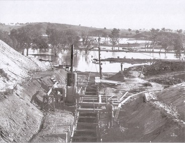 Wodonga & District Historical Society Inc
Album - Hume Reservoir Australia Album - Foundations for core wall of earth embankment, September 1921
This set of photos is from a leather bound album bearing the inscription "HUME RESERVOIR AUSTRALIA" plus 'The Rt. Hon. L. C. M. S. Amery, P. C., M .P.' all inscribed in gold. It was presented to The Rt. Hon. L. C. M. S. Amery, P. C., M. P, Secretary of State for Dominion Affairs on the occasion of his visit to the Hume Reservoir on 2nd November 1927. This album is of local and national significance as it documents the planning and development of the Hume Reservoir up to 1927. It was the largest water reservoir in the British Empire. The album records the pioneering engineering work that went into its construction.DEPARTMENT OF PUBLIC WORKS, N.S.W. RIVER MURRAY WATERS SCHEME. HUME RESERVOIR. 5. Foundations for core wall of earth embankment in New South Wales in September 1921. The River Murray in flood.hume reservoir australia, river murray waters scheme, hume weir diagrams, hume plan details -
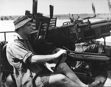 National Vietnam Veterans Museum (NVVM)
Photograph, Gibbons, Denis, Bofors Gun
Denis Gibbons (1937 – 2011) Trained with the Australian Army, before travelling to Vietnam in January 1966, Denis stayed with the 1st Australian Task Force in Nui Dat working as a photographer. For almost five years Gibbons toured with nine Australian infantry battalions, posting compelling war images from within many combat zones before being flown out in late November 1970 after sustaining injuries. The images held within the National Vietnam Veterans Museum make up the Gibbons Collection. A black and white photograph of Engineer crew of L/C Vernon Sturdie man a Bofors Gun on the Mekong River. The L/C had come under RPG fire from the river bank. photograph, bofor gun, gibbons collection catalogue, mekong river, landing craft vernon sturdie, engineers, denis gibbons -
Lakes Entrance Historical Society
Book, State Rivers and Water Supply Commission, The State of the Rivers Victoria Australia, 1983
The third (1983) report by the Standing Consultative Committee on River Improvement, giving an overall review of the state of the rivers of Victoria and the Murray. The subject is covered from the catchment to usage, pollution and drainage. Includes caswaterways, water supply, water pollution -
 Bendigo Historical Society Inc.
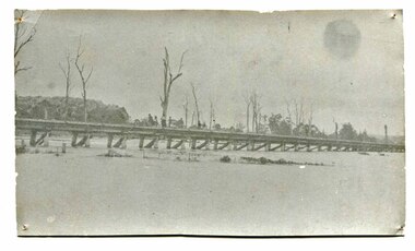
Photograph - Unknown bridge
BHS CollectionLarge black and white photograph showing a concrete bridge. Several men and women can be seen crossing the bridge, all are well dressed. Location and date unknown. bridge, bush, concrete bridge -
 Lakes Entrance Historical Society
Photograph - North Arm Bridge 1940, Lakes Entrance Victoria, 1940 c
Albert Newberry Collection photo number 1212Black and white photograph of North Arm bridge taken in 1940s showing little bridge crossing to the mud island and old Club Hotel Lakes Entrance Victoriabridges, engineering, gippsland lakes -
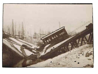 Bendigo Historical Society Inc.
Photograph - ROBERT DENIS KELLY COLLECTION: BRIDGE
Black and white photo: train bridge, collapsed, with train carriage sitting on 45-degree angle. Written on back in pencil: bridge from steel works, Louvoil ?person, robert denis kelly, world war 1, france, steelworks -
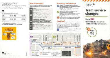 Melbourne Tram Museum
Pamphlet - Tram works on Swan St, Yarra Trams, Tram Service Changes, 2022
.1 - pamphlet provided at tram stops giving details of the works for 70 .2 - ditto - for Tram Network Upgrade - Swan St and Wallen Road Bridge, Richmond .3 - as for .1 - track reconstruction in Swan St between Stanley St and Stawell St Richmond or BurnleyShows the methods that Yarra Trams customers are advised of changes due to track replacement works. .1>.2 - Pamphlet - DL, four fold DL - Tram Service changes - 11/2022 to 18/2/2022 - Route 70 .3>.4 - Pamphlet - DL, four fold DL - Tram Network Upgrade - Swan St and Wallen Road Bridge, Richmond .5 - Newspaper clipping - Tram works on Swan Sttram works, track work, yarra trams, ptv, bridges, trams, tramways, richmond, burnley, route 70, wallen road bridge -
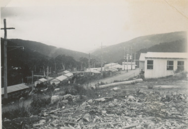 Lakes Entrance Historical Society
Photograph - Snowy Mountains Scheme c1950, Jack Palmer, 1950 c
Black and white photograph of view of village established for workers at Snowy Mountains Scheme Australian Alps Victoria. Also five other black and white photographs taken at same time of housing at village 6 x 8.5 cmcouncil, government -
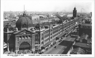 Melbourne Tram Museum
Postcard, Rose Stereograph Co, "Flinders Street Station and the Yarra, Melbourne", late 1920s
Rose Series postcard No. P 1666, titled "Flinders Street Station and the Yarra, Melbourne". This photo is looking southwest from St Paul's Cathedral over the station building along the Yarra river. The St Kilda/Port Melbourne and Queens bridge are in view, but not the Spencer St bridge which was built during the late 1920s. The AW Allen's Limited Confectionary Factory constructed in 1923-24 on Riverside Avenue dominates the landscape on the south side of the river directly behind the dome of the Flinders Street railways station. One very long set of horse-drawn carts can be seen alongside the center entrance to the railway station building in Flinders Street.Yields information about an aerial view of Melbourne late 1920sPostcard - printed real photograph with Rose Stereograph Co. name on the rear.tramways, trams, flinders st station, yarra river, bridges, railways, flinders st -
Tatura Irrigation & Wartime Camps Museum
Book, Water and Power, 1968
History of the Snowy Mmountains Scheme to 1968-9Pamphlet/soft cover/photo of Eucumbene Dam and Lake Eucumbene on front. Table of statistics on back cover. Illustratedwater, power, snowy mountains scheme, tatura, irrigatiaon, books, reference -
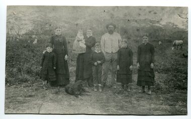 Orbost & District Historical Society
black and white photograph, 1994
The Roadknight family settled on Ewing's Marsh on what is now known as the Old Station In 1850. The Lakes Entrance run was occupied by the late Thomas Roadknight. In 1852 his brother William took charge. Soon after this Corringle Station was occupied by the late T. T. Stirling. William was born at Collingwood, the son of William Roadknight and Jane Stirling. The Roadknight family came from Colac on board the Enterprise to their new home at Cunninghame. The house on the hill, now Pine Hill was named Merrangbaur (home of the lyrebird). William held the Lake Tyers and Snowy River run in partnership with Thomas Telfer Stirling who took up the eastern end of the run on the west bank of the Snowy River. The run included Ewing‟s Marsh — the Ewing brothers were earlier landowners but had no formal run in this area. William served four terms on the Tambo Shire Council as a representative of the Bendoc Riding despite not being a resident of the Riding. He was then elected to the Orbost Shire as a West Riding councillor in 1896-97, 1897-98 and was Shire President in his final year 1898-99 This item is associated with Roadknight family who were early settlers in the Orbost district.A black / white photograph of a family group of mother, father and six children standing outdoor. There is a dog lying in front .roadknight-william ewing's-marsh old-station-orbost -
 Federation University Historical Collection
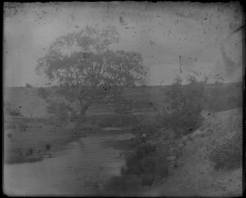
Photograph - Glass Plate, Landscape by Henry Sutton
Henry Sutton was born in Ballarat into the musical Sutton Family. He is known as an important Australian inventor. Image of a landscape with river and large tree taken off a glass plate.henry sutton, glass plates, photography -
Glenelg Shire Council Cultural Collection
Negative - Negative - Mouth of Glenelg River, Nelson, Victoria, c. 1936
Transparency for black and white photo. Mouth of Glenelg River at Nelson Vic -
Glenelg Shire Council Cultural Collection
Photograph - Photograph - Casterton, Victoria, n.d
SOURCED FROM CASTERTON TOWN HALL (FORMER SHIRE OF GLENELG)Black and white photo. Erosion near Casterton. Car on the banks of riverBack: Round, purple photographer's stampcasterton, glenelg river -
Glenelg Shire Council Cultural Collection
Photograph - Photograph - Casterton, Victoria, n.d
Sourced from Casterton Town Hall (Former Shire of Glenelg)Black and white photo. Same as 7225 (soil erosion, river bank) -
Glenelg Shire Council Cultural Collection
Photograph - Photograph - Casterton, Victoria - Erosion bank, n.d
Sourced from Casterton Town Hall (Former Shire of Glenelg)Black and white photo, same as 7227 (soil erosion, river bank) -
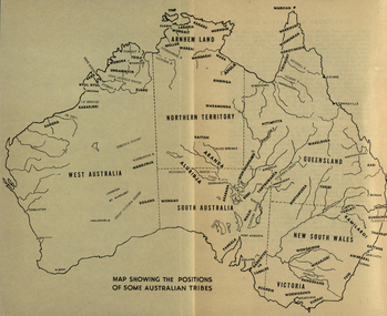 Federation University Historical Collection
Map, Australia Showing Position of Some Australian Tribes, c1945, c1945
Digitised directly from "The Australian Aborigines: How to understand them" by A.P. ElkinMap of Australia showing states, river system and some Aboriginal Tribes.aboriginal, aborigines, kurnai, worworung, wongaibon, wiradjuri, dieri, wakelbura, pittapitta, waramunga, binbinga, anula, mara, waral, mulluk, larakia, worora, djaru, karadjerri, kogara, wongaii, pankala, tabalde, buandie