Showing 10834 items
matching maps
-
 Falls Creek Historical Society
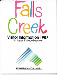
Booklet - Brochure - Falls Creek Visitor Information 1987
Part of an annual marketing campaign, this booklet was designed to provide information for planning a holiday at Falls Creek for the winter of 1987. It includes extensive details about activities, facilities and accommodation in the Village as well as contact information to make necessary bookings.This item is important because it documents seasonal activities at Falls Creek Alpine ResortFold out information guide for Falls Creek winter holidays 1987 including images, text and maps,falls creek marketing, falls creek winter programs, falls creek village -
 Melbourne Tram Museum
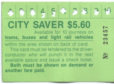
Ephemera - Ticket - City Saver, The Met, 1988c
Used by The Metropolitan Transport Authority (The Met) to provide a multi-journey trip ticket within a nominated City (CBD) area. Has been used for 10 trips. A check ticket was issued by a conductor for each trip made. Has details of the availability on the rear. Notes that the ticket is available for trams, buses and light rail. Previous issues did not have light rail listed. The light rail to St Kilda and Port Melbourne commenced in Nov. 1987. Has The Met logo on the rear. Demonstrates a multi-use ticket used by The Met in the City area of Melbourne.City Saver –No. 23457 - $5.60 printed on a green card with a map of the available CBD travel area on the back.public transport, tickets, the met, trams, tramways, city saver -
 Box Hill Historical Society
Book, John M. Wilkins, Transforming Victoria 1894-1994: a Century of Electricity Supply by Victoria's Local Government 1894-1994 and the S.E.C.V. 1921-1994, 2017
A chronological history of electricity supply in Victoria by local government and by the State Electricity Commission231 pages. Includes maps, graphs, bibliography and index. Also includes colour and black & white photos non-fictionA chronological history of electricity supply in Victoria by local government and by the State Electricity Commissionbox hill electricity supply, electricity supply, state electricity commission of victoria, secv -
 Bendigo Historical Society Inc.
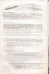
Document - MCCOLL, RANKIN AND STANISTREET COLLECTION: INDENTURE GOLD MINING LEASE 9201 BALLAARAT
6 page document plus map: indenture, gold mining lease dated 9th August 1960, between the Crown and North Deborah Mining Company, carrying on operations in the Parish of Moorarbool West . Key on map indicates depth to which land may be excised. On map: Mining District of Ballarat, County of Grant, Parish of Moorarbool West. Total area: 285 acres 1 rood, 20 perches. Vol 334, Fol 202.bendigo, mining, deborah gold mines -
 Bendigo Historical Society Inc.
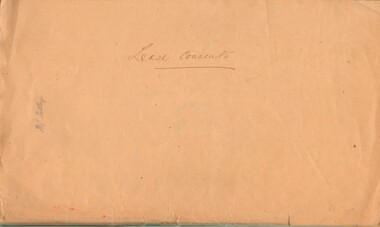
Document - MCCOLL, RANKIN AND STANISTREET COLLECTION: LEASE CONSENTS
Manilla Folder containing correspondence and consents relating to the following Gold Mining Leases; 10819, 10027 (North Virginia Gold Mining Co.);, 10370 Great Eastern (Bendigo), includes map; 10014, South monument; 10059 North Neanger, with map; 10072 ; 10104; North Virginia; 10068 New Don Company with Map; 10032 New Balaclava, Whroo; 10026 East Clarence Gold M/C. Dated 1933 - 34gold mines, bendigo, gold mines, north virginia, great eastern, south monument, north neanger, new don, east clarence, new balaclava -
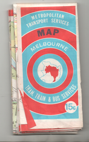 Melbourne Tram Museum
Map, Ministry of Transport, "Melbourne Transport Services Map - Tram, Train and Bus Services", c1974
Fold out map (27 sections 9 across x 3 deep), coloured of Melbourne's Tram and Bus routes, route numbers, rail lines, detailed for the central part of Melbourne and insert section for Frankston. On rear description of routes, private bus routes and map of Melbourne metro lines. Has contact details for bookings and lost property etc. Priced 15c Inscription dates the map as 1974. Two copies held.On front cover in ink "#3" in top right hand corner and "4 G 33 1974" along bottom edge of the first copy.trams, tramways, melbourne, map, tram & bus services, railways, mmtb, minister for transport -
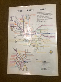 Melbourne Tram Museum
Map, Melbourne & Metropolitan Tramways Board (MMTB), "Tram Route Guide", Jun. 1982
Full colour map or poster printed on clear plastic with an adhesive peel off backing sheets, titled "Tram Route Guide". Map dated 6/82, showing routes with route numbers and names of main destinations. Has notes about the services, weekend bus replacements and telephone numbers for information. 1982 Note this version does not show the route 88 extension as similar map 1098 or 3765 does, but is a later version.trams, tramways, mmtb, map, routes, posters -
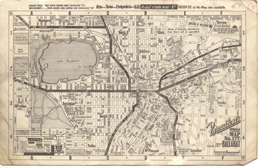 Ballarat Tramway Museum
Map, Broadbent's, "Broadbent's Official Map 177 Ballarat", c1960
Printed street map titled "Broadbent's Official Map 177 Ballarat" on a medium weight (200gsm?) card. Shows the suburbs of Ballarat, but not Sebastopol, rail lines and tram routes, schools, some churches, hospitals, parks and some features. Does not show the full length of the Lydiard St or Sebastopol tram lines. Has scale, national route numbers and distance from Ballarat PO marked on the map. In bottom left hand corner, has Broadbent's north point logo and notes that it is the 66th year of publication of road maps. Gives telephone number as MB 2021 in top right hand corner.Initials "GY" in pencil and red ink in top right hand corner.trams, tramways, map, ballarat, broadbent's, railways -
 Kew Historical Society Inc
Map, MMBW, MMBW Plan No.117 Heidelberg & Kew, 1900-1910
The Melbourne and Metropolitan Board of Works (MMBW) was established by an act of the Victorian Parliament in 1890 to prepare for and to implement a sewerage and water reticulation system across what was then inner Melbourne, its surrounding and middle distance suburbs, including Kew. The MMBW was disbanded in 1991.The map collection of the Kew Historical Society has at its core the historic maps assembled and originally stored in the City Engineer's Department of the City of Kew. These include maps in a number of scales. The vast majority of maps were produced by the MMBW in the first two decades of the twentieth century, and are solid working maps, backed by linen for durability. These maps are historically significant to Kew, the City of Boroondara and to the history of the development of state utilities in Victoria. A number of the Kew maps have additional details added by former municipal officers, including the levels reached by various floods. As these were working documents, information was added to them long after the period of their initial production and distribution.Early map of part of the Borough of Kew, created in the early twentieth century, at a scale 160 ft to 1 inch. The map covers what was then the north eastern part of Kew showing the natural landscape and limited development on the south side of the Yarra River. In the Kew section, south of the river, the land is occupied currently by the Greenacres and Kew Golf Clubs. The map shows the extent of urban development by that time and the outlines of the few built structures in the municipality. The height above sea level of all parts of the landscape are indicated numerically in feet. Contour lines and the levels of historic floods were added in ink to the map at a later stage. MELBOURNE AND METROPOLITAN BOARD OF WORKS / PLAN NO. 117 / HEIDELBERG & KEW melbourne & metropolitan board of works, mmbw maps, borough of kew, cartography, mmbw plan no. 117, kew (vic.) -- maps, heidelberg (vic.) -- maps -
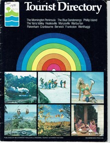 Phillip Island and District Historical Society Inc.
Booklet, Tourist Directory 1981 and Guide to Phillip Island & surrounds 1995
HistoricalLarge black booklet with brightly coloured cover with tourist photos. Inside is black type with descriptions, maps, advertisements and photos. Guide is smaller with white and red writing and maps. Inside it has red writing on history, climate and information on Phillip Island and small advertisements of attractions.Tourist Directory, Published by Westernport Healesville Regional Tourist Authority Victoria. Printed by Standard Newspapers, Cheltenham. Guide to Phillip Island & surrounds.Phillip Island Information Centre RMB 1305 Newhaven.tourism, tourist brochure, accomodation, restaurants, map of phillip island -
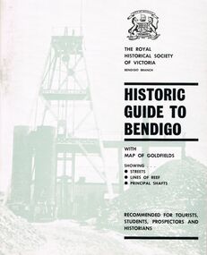 Bendigo Historical Society Inc.
Book - HISTORIC GUIDE TO BENDIGO
Three books titled ' The Royal Historical Society of Victoria Bendigo Branch Historic Guide to Bendigo with map of goldfields showing streets, lines of reef, principal shafts. Recommended for tourists, students, prospectors and historicans.' Sixth Edition. Cambridge Press, Bendigo. Maps, photos, diagrams.bendigo, history, gold mining, book, books, bendigo, bendigo history, victoria, victorian history, australian history, gold, gold fields, the royal historical society of victoria, gold discoveries -
Bendigo Historical Society Inc.
Map - HEATHCOTE : COUNTY OF BENDIGO, 19-2-1942
Map. Heathcote, County of Bendigo. County of Dalhousie, McIvor Creek,Wallan and Bendigo Railway, By authority H.E. Daw, Government Printer, Melbourne. Drawn and reproduced at the Department of Lands and Survey, Melbourne. 19-2-1942. Price 2/-. (number 90 in map cupboard 1)H.E. Daw, Government Printer, Melbourne.map, bendigo, heathcote -
Bendigo Historical Society Inc.
Map - RAVENSWOOD, COUNTIES OF BENDIGO & TALBOT, 12-12-22
Map, Ravenswood, Counties of Bendigo & Talbot, Shelbourne, Walmer, Harcourt, Sutton Grange, Mandurang, Lockwood.By Authority A.J.Mullett, Govt. Printer, Melbourne. Photo-Lithographed at the Dept. of Lands and Survey, Melbourne by W.J.Butson 12-12-22, Price1/-. (number 87 in map cupboard 1)A.J.Mullett. Govt. Printer, Melbourne.map, bendigo, ravenswood -
Bendigo Historical Society Inc.
Map - PARISH OF STRATHFIELDSAYE : COUNTY OF BENDIGO, 1-10-19
Map. Parish of Strathfieldsaye, County of Bendigo, Wellsford, Sandhurst, Sedgwick, Eppalock, Axedale. Photo-Lithographed at the Department of Lands and Survey, Melbourne by W.J.Butson, 1-10-19. Price 1/-. By authority A.J. Mullett, Government Printer, Melbourne. (number 34 in map cupboard 1)A.J. Mullett, Govt. Printer, Melbourne.map, bendigo, strathfieldsaye -
Bendigo Historical Society Inc.
Map - SEDGWICK : COUNTY OF BENDIGO, 1963
Map. Sedgwick, County of Bendigo, Strathfieldsaye, Mandurang, Sutton Grange, Lyell, Eppalock County of Talbot Border. By authority A.C. Brooks, Government Printer, Melbourne. Drawn and reproduced at the Department of Lands and Survey, Melbourne.1963, Price 2/-. (number 30 in map cupboard 1)A.C. Brooks, Government Printer, Melbourne.map, bendigo, sedgwick -
Bendigo Historical Society Inc.
Map - SEDGWICK : COUNTY OF BENDIGO, 18-12-20
Map. Sedgwick, County of Bendigo,Strathfieldsaye, Mandurang, Sutton Grange, Lyell, Eppalock. Photo-Lithographed at the Department of Lands and Survey, Melbourne by W.j. Butson 18-12-20, Price 1/-. By authority A.J.Mullett, Government Printer, Melbourne. (number 29 in map cupboard 1)A.J. Mullett, Government Printer,Me;bourne.map, bendigo, sedgwick -
Whitehorse Historical Society Inc.
Document - Correspondence, Letter and Map Schwerkolt houses, 9/11/1993
Letter to W. Gray, Nunawading Historical Society from Glyn France enclosing map of Schwerkolt property and rough plan of old stone house drawn by Arthur Schwerkolt [map filed at A-SP 120]. Gives information about dates of building 'old' and 'new' houses.schwerkolt, arthur, schwerkolt, myra, france glyn, schwerkolt cottage -
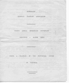 Ballarat Tramway Museum
Ephemera - Tour Notes, Australian Electric Traction Association (AETA), "AETA Easter 1958, tour notes, Ballarat", Apr. 1958
Yields information about a Australian Electric Traction Association tour to Ballarat, Bendigo and Geelong Tour, Easter 1958 tramcars with maps.A eight page booklet tour notes for AETA's 4th Annual Easter Convention in Melbourne and tour to Ballarat, Sat. 5/4/1958 with brief history, itinerary, map, Geelong map, tram car notes and Bendigo. Duplicated by Gestener process. Copy to be provided if loaned.secv, ballarat, geelong, aeta, bendigo, provincial tramways -
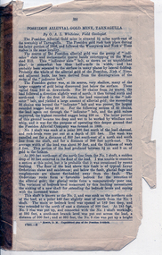 Tarnagulla History Archive
Pages from a book: Poseidon Alluvial Gold Mine, Tarnagulla, Poseidon Alluvial Gold Mine, Tarnagulla, circa 1916
Murray Comrie Collection. Pages from a book (unknown), this excerpt titled 'Poseidon Alluvial Gold Mine, Tarnagulla' by O.A.L. Whitelaw, Field Geologist. Includes a map (also extracted from the book) with title 'Poseidon Alluvial Gold Mines'. Map of the mines entire workings, above and below ground. tarnagulla, poseidon, mine, mining, gold -
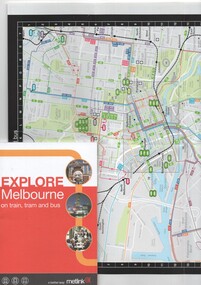 Melbourne Tram Museum
Book, Metlink, "Explore Melbourne on train, tram and bus", Jan. 2009
Book - 42 pages + cover + foldout map, perfect bound - titled "Explore Melbourne on train, tram and bus" giving details of many locations, venues that could be travelled to by public transport, how to buy Metcards, map of the inner area and transport routes. Places of Interesttrams, tramways, melbourne, local history, metlink, public transport, map -
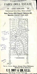 Ringwood and District Historical Society
Flyer, Residential Land Sale Sub-division - Fairy Dell Estate, Warranwood, Vic. - circa 1950s
Land sale advertisement for 50 home sites with map of Sub-division showing layout of streets and allotments, summary of local features and services and terms of sale, and copy of sectional map of Crown Allotments 20 & 21B Parish of Warrandyte also showing layout of Sub-division.Subdivision includes Grandview Grove (later Bemboka Road), Merrill Crescent and Kerry Road, Warranwood. Estate Agents - V.C. Swift & Son R.E.S.I., Main Street, Croydon, Phone 20. Solicitors - Morgan, Fyffe & Mulkearns, 108 Queen Street, Melbourne. Handwritten 1970s real estate price notations for some blocks. -
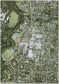 Eltham District Historical Society Inc
Photograph - Digital Photograph, MetroMap, Aerial Photo: Eltham Town Centre, 2021, 2021
Map acquired by Nillumbik Shire Council as part of an investigation into proposed transport upgrades.aerial photo, eltham town centre -
Glen Eira Historical Society
Document - Maysbury, Maysbury Avenue, 1, Elsterwick
Two photocopies of a map showing the mansion Maysbury, before the construction of Maysbury Avenuemay street, st.georges road, staniland grove, sanham street, king street, beavis street, grafton street -
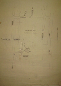 Federation University Historical Collection
Plan, Sovereign Hill Recreation Reserve and Surrounds
This map was probably produced around the time that the Sovereign Hill Museums Association was established. A simple plan with black marking on paper. It shows the Sovereign Hill Recreation Rerserve, including the swimming pool located near the Sovereign Hill Trig Point, showers, toilets, kiosk, bandstand and pine trees. The plan also depicts the Ballarat East streets surrounding Sovereign hill, including Geelong Road, Magpie Street, Stephens Street, Tregurtha Street, Dunn Street, Bourke Street, Gladstone Street and Robertson Street. The scale is 2 chains to 1 inch.sovereign hill, swimming pool -
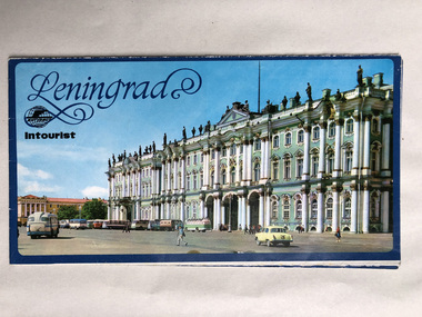 Robin Boyd Foundation
Pamphlet, Intourist, Leningrad
Robin and Patricia Boyd visited Russia in 1964. A pamphlet containing a map of the city.walsh st library -
 Apollo Bay Museum
Audio - Richard Collopy on middens on the Coastal Walk route
Recorded by Gadubanud Traditional Custodian Richard Collopy as part of the Heart Maps projectapollo bay, great ocean road, gadubanud, middens -
Federation University Historical Collection
Booklet - Program, Booklet, Newspaper Cuttings, Map, Quad Sports B.T.C., S.M.B., F.S 1961 and magazine, 4 October 1961
The Diploma Course at the Ballarat School of Mines usually took four years to complete hence the title of the booklet "Your Four Years with Us".Program: Cream card, A4 size, folded in half to make 4 page program. Booklet: 8 cream pages plus cover with image of Ballarat School of Mines on front 7 small newspaper articles Map of SMB in black ink on cream paperProgram: Front: 1961, "Quad" Sports, B.T.C, S.M.B., F.S. printed in black ink. "Michael Whiteside SMB" handwritten on top right hand corner. Inside: Starting time, Event, Records, First, Second, Third, Time or Distance typed with three handwritten names, Michael Whiteside SMB, Philip Lockyer SMB, Judith Christensen BTC and time handwritten 2 Min 8.2 Sec for Men, 880 yards event. Back: Signatures handwritten on back. A KING & Sons Ballarat logo bottom at back Booklet: Michael N Whiteside SMB signature in blue ink on top right hand corner of cover. Inside cover: "This book was stolen from Michael N Whiteside handwritten in blue ink Map has lines drawn from building 3 to 10 to 15 to 14 to 7 with various numbers in circles hand drawn. ballarat teachers' college, school of mines ballarat, ballarat school of mines, quad sports, 1961, philip lockyer, michael whiteside, judith christensen, sports program, program, sports, lake relays, city oval, stewart house, barry house, track events, bob norton, technical schools' regatta, lake wendouree, geelong technical college, gordon institute of technology -
 Bendigo Military Museum
Photograph - Army Survey Regiment’s Officers, Warrant Officers and Sergeants and Squadrons, at Fortuna, Bendigo, 1982
This is a set of six staff photographs of the Army Survey Regiment’s Officers, Warrant Officers and Sergeants, and each of its four Squadrons at Fortuna, Bendigo in December 1982. Note - Air Survey Squadron’s photo was probably taken in July 1982 as they appear in winter dress. Air Survey Squadron was responsible for aerotriangulation, photogrammetric feature extraction and the AUTOMAP 1 system. Typical tasks were flight planning the acquisition of aerial photography, pugging, mensuration and block adjustments, photogrammetric extraction of topographic features from aerial photography, digital feature editing, map compilation, operating the scanner/plotter, operating the AUTOMAP 1 system and computer programming by civilians. Cartographic Squadron was responsible for the production of the following military products: Joint Operation Graphics, small-scale RAAF Air Charts, large-scale topographic line maps and orthophotomaps. Cartographic technician tasks were scribing, compiling, retouching, masking, type setting, type stickup, terrain embossing, correcting and proving quality control. Headquarters Squadron was responsible for the planning and coordination of map production and contracts. It also performed administrative and support functions such as personnel administration, pay, finance, transportation, records, map Library, kitchens, messes and facility maintenance. It was staffed by Army personnel from RASvy, RACT, AACC, RAAOC and RAEME corps. Other supporting staff at this time included the RAAF Liaison Officer, RAN Liaison Officer and several civilians employed in administration, the Q-Store and grounds maintenance. A component of the Army Svy Regt’s cartographic map production was carried out by the Detachment, a sub-unit located at Bonegilla next to the School of Military Survey. Lithographic Squadron was responsible for the reproduction of map materials and printing of military map products. The main tasks undertaken by photographic technicians were photographic enlargements, reductions and duplication of map reproduction material and processing of aerial photography. Printing technician tasks included platemaking, offset printing, map stock despatching and proofing.This is a set of six staff photographs of the Army Survey Regiment’s Officers, Warrant Officers and Sergeants, and its four Squadrons, at Fortuna, Bendigo, 1982. The black and white photographs were printed on photographic paper and are part of the Army Survey Regiment’s Collection. The photograph was scanned at 300 dpi. No personnel are identified. No personnel are identified. .1P – Annotated on front “OFFICERS MESS DEC ’82” .2P – Annotated on back “SGTS MESS DEC ’82” .4P– Annotated on front “CARTO SQN DEC ’82” .5P– Annotated on front “HQ SQN DEC ’82”royal australian survey corps, rasvy, army survey regiment, army svy regt, fortuna, asr, air survey, carto, litho -
 Warrnambool and District Historical Society Inc.
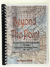
Booklet, Beyond the Point, 2007
This book was written in 2007 by Margaret McOrist to mark the 150th anniversary of the arrival in the Warrnambool area of John Logan. It is a sequel to a 1991 book, ‘Clotted Cream and Mangels’ which told the story of John Logan and his wife Mary Gardner. They lived at Hopkins Point, Warrnambool and the book, ‘Beyond the Point’ tells the story of the Logan descendants. When the farm land was sub-divided and sold the nearby beach was named ‘Logans Beach’. This book is of considerable interest as it tells the story of the descendants of important early settlers, John Logan and Mary Gardner. The area where they first settled is now of major interest as Logans Beach (named for the Logan family) is the well-known whale watching area. Southern Right Whales return to this beach each year and the females calve and remain up to three months at this beach, making it an important ‘whale nursery’. This is a soft cover book with black plastic ring binding and clear plastic sheets covering the front and back paper covers. The front cover has a reproduction of an 1891 map of Warrnambool and district with the title of the book and other information superimposed on the map. The back cover is black. The book has 101 pages and contains information on the Logan families who lived at Tooram in Allansford and their descendants. There are many black and white and colour photographs, diagrams, maps and family trees. Front Cover: ‘Beyond the Point, 150 years since the arrival of Irish ancestor, John Logan, Hopkins Point, Warrnambool, Victoria, 1857-2007, by Margaret McOrist’. john logan and mary gardner, hopkins point, logans beach, tooram, history of warrnambool -
 Bacchus Marsh & District Historical Society
Map, Lerderderg District Proposed Irrigation and Water Supply Trust (C). Plan showing overlap in boundaries of the Trust District
The 1886 Irrigation Act in Victoria introduced the first legislation in Australia designed to enable the creation of a detailed scheme for agricultural irrigation. Part of the legislation saw the use of government funds for local irrigation projects. These local projects were managed by local irrigation trusts. The Lerderderg Irrigation and Water Supply Trust was formed in 1890. Printed paper map of the proposed Lerderderg District Irrigation and Water Supply. Plan showing overlap in boundaries of Trust District referred to in Mr Burke's report. The Lerderderg District lies within the Parishes of Korkuperrumul and Merrimu in the County of Bourke. At the top of the map above its title is the letter 'C; in capital lettering. A note on this map states: 'Portion of Bacchus MarshUrban District included in area of proposed Trust District shown by hatched shaded lines thus /////////////irrigation, water supply, lerderderg irrigation and water supply trust