Showing 14052 items matching "snowy-river-bridge"
-
 Clunes Museum
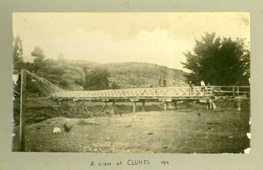
Photograph, CIRCA 1912
PHOTOGRAPH OF BRIDGE TO STEPS AT LOWER FRASER STREET, CLUNES.A VIEW OF CLUNES.local history, photography, photographs, bridges -
 Rutherglen Historical Society
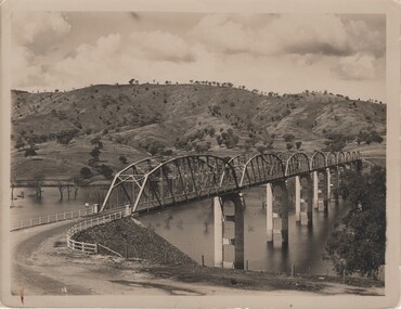
Image, c 1930
Black and white photograph of the Bethanga Bridge with hills in the background.On back of photo: "Hume Weir" and an oval rubber stamp "V. Peterson | Photographer | Hume Reservoir"hume dam, hume weir, hume reservoir, lake hume, bethanga bridge -
 Ballarat Heritage Services
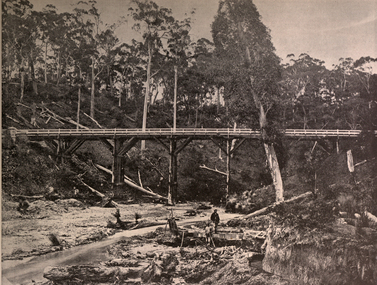
Image, Miner's Claim Near Daylesford, Victoria, c1897
Men mine for gold under a bridge at Dayelsford, Victoriadaylesford, mining, bridge -
 Bendigo Historical Society Inc.
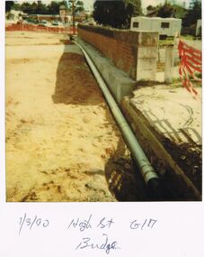
Photograph - CASTLEMAINE GAS COMPANY COLLECTION: PHOTO PIPE, 01/03/1990
Pipe in the Ground - High Street Bridge G/A - 01.03.1990Polaroidorganisation, industry, gas and fuel -
 Bendigo Historical Society Inc.
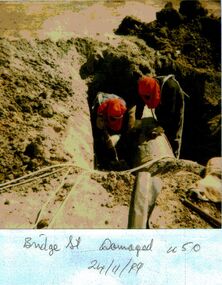
Photograph - CASTLEMAINE GAS COMPANY COLLECTION: PHOTO BRIDGE STREET, 24/11/1989
Damaged u50 - Bridge Street - 24/11/1989Polaroidorganisation, industry, gas and fuel -
 Port Melbourne Historical & Preservation Society
Photograph - Tailor shop Bridge Street, David RADCLIFF, c. 2022
6 images taken by donor and 3 taken from Marshall White & Co website when the property was sold in 2022.9 digital images of the Bridge Street tailor shop marshall white & co., bridge street, business and traders - tailors and clothing -
 Ballarat Heritage Services
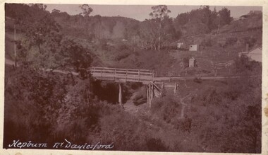
Photograph - Photograph - Black and White, Hepburn Near Daylesford
A timber bridge spanning Spring Creek at Hepburn Springs.daylesford, hepburn springs, spring creek, spring creek bridge, mineral springs reserve -
 Bendigo Historical Society Inc.
Slide - Mouat Crawford Collection: Farming Life in the Wimmera, c1960
Bridge to Mia Mia at Redesdale. Used as a teaching aid.ILFORDagriculture, redsdale, mia mia, mouat crawford collection, bridge -
Lakes Entrance Historical Society
Domestic object - Souvenir Dishes
Two souvenir dishes with photographs of North Arm Bridgetourism, mementos -
 Port of Echuca
Black and white photograph
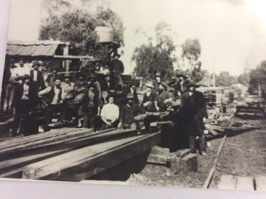
Macintosh's sawmill was on the banks of the Murray River in Echuca east where the Banyule State forest is now located. A tramway ran out to it from the main rail line near the iron bridge. Macintoshes Sawmill was one of the largest in the area. (Ref. Clare Jackson. )Macintoshes sawmill was set up by James Macintosh in 1868 in Echuca East. His sawmill prospered and in 1878 was "equal to five normal sawmills" (Ref; Coulson, Helen, "Echuca Moama On the Murray." P.158) He also owned 2 paddle steamers and 8 barges. The Macintosh Family contributed substantially to the development of Echuca East, but by 1901 the Family was in severe debt and were forced to sell the sawmill to the Nicholas Family.A black and white photograph of a large group of men outside a sawmill, reputed to be Macintoshes Sawmill in Echuca East.On the back of the photograph written in pencil are the words "Believed to be workmen at McIntosh's mill (Charlie Dowell says)macintosh's sawmill, sawmill industry, echuca east, banyule state forest, macintosh james, dowell, charlie, logging industry, jackson, clare -
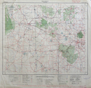 Federation University Historical Collection
Map, Ballarat, Victoria, 1942, 1942
Two copies of a map of the district around Ballarat, including Creswick, Scarsdale, Smythesdale, Lake Bolac, Ararat, Talbot, Sebastopol, Maryborough, Cardigan, Skipton, Mount Emu Creek, Leigh River, Fiery Creek, Hopkins River. Street names are listed on the back of the map. It includes roads, timber, creeks, rivers, telephone lines, railwayPrinted in red at the base of the map "This map is an official document. If found, itmust be handed in to the nearest Military Headquarters or Police Station.ballarat, map, world war two, skipton, creswick, ararat, lake bolac -
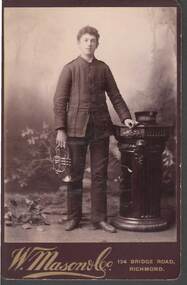 Bendigo Historical Society Inc.
Photograph - CABINET PORTRAIT OF A YOUNG MAN
Sepia Cabinet Portrait of a young man on brown mount board. The young man is wearing a uniform and has a trumpet or bugle in his right hand. His left hand is resting on a pedestal which has a cap on it. On the cap band is: 'The Salvation Army? - - -.W. Mason & Co. 134 Bridge Road, Richmondphotograph, portrait, male, cabinet portrait of a young man, the salvat-, w mason & co richmond -
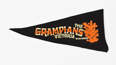 National Wool Museum
Pennant
DADSWELL'S BRIDGE MOTEL Vic. THE GRAMPIANS VICTORIA WILDFLOWERSgrampians, victoria -
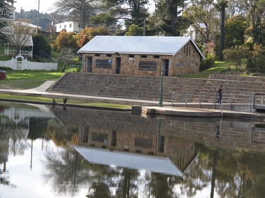 Ballarat Heritage Services
Photograph - Photograph - Colour, Clare Gervasoni, Lake Daylesford Swimming Pooll, Stone Shed and Terracing, Lake Daylesford, 2020, 18/09/2022
Colour photograph of a sandstone building and terracing at Central Springs, Lake Daylesford.This Terracing and Bridge eracted by Springs Improvement Committee 1952central springs, daylesford, lake daylesford, mineral water, kiosk, sandstone, springs improvement committee, swimming pool, swimming sheds -
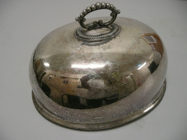 Bendigo Historical Society Inc.
Domestic Object - LARGE MEAT COVER
Large oval shaped silver plated meat cover with handle and a Lion rampant clutching a sheaf of wheat engraved on one side.Mappin Brothers 222 Regent Street and London Bridgedomestic equipment, food storage & preservation, meat cover, di500 -
 Kew Historical Society Inc
Photograph - High Street, Kew East
In 1980, Mr Laurie Bennett presented the Kew Historical Society with a number of photographs and postcards from the estate of his mother Eileen Mary Bennett (nee Clark). His mother was the daughter of Lawrence FH Clark(?-1946) and Mary Clark (?-1925) of 22 Harp Road, East Kew, in whose yard the photograph was taken. A year before the donation occurred a notice appeared in the Canberra Times stating that: "BENNETT, Eileen Mary. — May 8th at Tuross Heads, N.S.W. Late of 22 Harp Rd, East Kew, (Vic). Dearly loved wife of the late Harold Bennett, loved mother and mother in law of Laurie and Shirley (Melbourne), Kevin and Doreen (Canberra), grandmother of Linda, Stephen, Paul, Gabrielle, Peter, Mark and Jon."Part of a large collection of photographs and postcards in the collection. This dated photograph allows the researcher to identify development by 1916 in Kew and East Kew.High Street, Kew East in 1916 looking west. "High Street, East kew, near rail bridge."laurie bennett, eileen mary bennett, eileen mary clark -
 Stawell Historical Society Inc
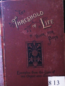
Book, The Threshold of Life, 1889
Campbells Bridge Presbyterian Sunday School. To Robert Traskstawell education religion -
 Stawell Historical Society Inc
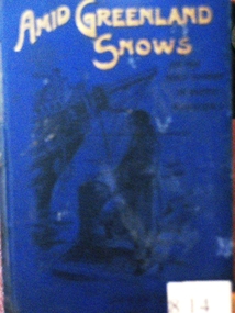
Book, Jesse Page, Amid Greenland Snows, 1893
To Albert Trask by Presbyterian Sabbath School Campbells Bridgestawell education religion -
 Stawell Historical Society Inc
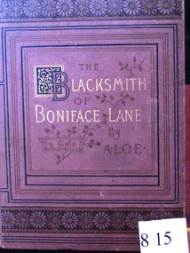
Book, A.L.O.E, The Blacksmith of Boniface Lane, 1892
Campbells Bridge Presbyterian Sunday School. To Robert Traskstawell education religion -
 Stawell Historical Society Inc
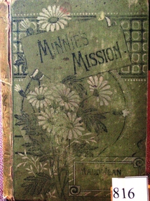
Book, Maud Jean Franc, Minnie’s Mission, 1889
Campbells Bridge Presbyterian Sunday School. To Martha Traskstawell education religion -
 Marysville & District Historical Society
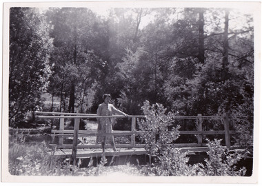
Photograph (Item) - Black and white photograph, 1954
A black and white photograph taken at the Fruit Salad Farm in Marysville in 1954.A black and white photograph taken at the Fruit Salad Farm in Marysville in 1954.Rosalie - 1954/ Marysville Fruit Salad Farm Bridgemarysville, victoria, australia, fruit salad farm, accommodation, restaurant, photograph -
![Photograph - Construction of the F19 [Eastern Freeway], Ron Setford, May 1976](/media/collectors/550653872162f11fb04854aa/items/6828851364071e7c58e697c5/item-media/6828853364071e7c58e69987/item-fit-380x285.jpg) Kew Historical Society Inc
Kew Historical Society IncPhotograph - Construction of the F19 [Eastern Freeway], Ron Setford, May 1976
Ron Setford and his wife Grace Setford lived in Tanner Avenue, East Kew, from c.1946 to c.1995. A keen photographer, he recorded the changing face of Kew over a 20 year period. Apart from 30 photographs of built structures and places in Kew dating from 1960 and 1961, 145 of his 35mm colour slides chronicle the development of the F19 (later renamed Eastern) Freeway through the Yarra Valley in Kew over a five year period from c.1972 to c.1977. This important collection was donated to the Society by his granddaughter in 2025.This collection of 175 35mm slides is of local and statewide significance, owing to its subject matter, particularly the major development of road transport infrastructure during the 1970s with the construction of the Eastern Freeway. The photographer also took care to annotate and date most of his slides which enable the researcher to pinpoint temporal and spatial locations."Freeway bank conservaion near Belford Rd Bridge"ron setford, eastern freeway, f19 freeway -
![Photograph - Construction of the F19 [Eastern Freeway], Ron Setford, August 1973](/media/collectors/550653872162f11fb04854aa/items/6808c302025de50d1e73108d/item-media/6808c31e025de50d1e7312ad/item-fit-380x285.jpg) Kew Historical Society Inc
Kew Historical Society IncPhotograph - Construction of the F19 [Eastern Freeway], Ron Setford, August 1973
Ron Setford and his wife Grace Setford lived in Tanner Avenue, East Kew, from c.1946 to c.1995. A keen photographer, he recorded the changing face of Kew over a 20 year period. Apart from 30 photographs of built structures and places in Kew dating from 1960 and 1961, 145 of his 35mm colour slides chronicle the development of the F19 (later renamed Eastern) Freeway through the Yarra Valley in Kew over a five year period from c.1972 to c.1977. This important collection was donated to the Society by his granddaughter in 2025.This collection of 175 35mm slides is of local and statewide significance, owing to its subject matter, particularly the major development of road transport infrastructure during the 1970s with the construction of the Eastern Freeway. The photographer also took care to annotate and date most of his slides which enable the researcher to pinpoint temporal and spatial locations."Eastern Freeway / Belford Rd Bridge / August 73"ron setford, eastern freeway, f19 freeway -
![Photograph - Construction of the F19 [Eastern Freeway], Ron Setford, May 1974](/media/collectors/550653872162f11fb04854aa/items/6831c9f7675df5c02f042c18/item-media/6831ca10675df5c02f042c6e/item-fit-380x285.jpg) Kew Historical Society Inc
Kew Historical Society IncPhotograph - Construction of the F19 [Eastern Freeway], Ron Setford, May 1974
Ron Setford and his wife Grace Setford lived in Tanner Avenue, East Kew, from c.1946 to c.1995. A keen photographer, he recorded the changing face of Kew over a 20 year period. Apart from 30 photographs of built structures and places in Kew dating from 1960 and 1961, 145 of his 35mm colour slides chronicle the development of the F19 (later renamed Eastern) Freeway through the Yarra Valley in Kew over a five year period from c.1972 to c.1977. This important collection was donated to the Society by his granddaughter in 2025.This collection of 175 35mm slides is of local and statewide significance, owing to its subject matter, particularly the major development of road transport infrastructure during the 1970s with the construction of the Eastern Freeway. The photographer also took care to annotate and date most of his slides which enable the researcher to pinpoint temporal and spatial locations."New Chandler H/way Bridge / May 74"ron setford, eastern freeway, f19 freeway -
![Photograph - Construction of the F19 [Eastern Freeway], Ron Setford, October 1976](/media/collectors/550653872162f11fb04854aa/items/682afcd6b92b884efed2688f/item-media/682aff26b92b884efed26ad9/item-fit-380x285.jpg) Kew Historical Society Inc
Kew Historical Society IncPhotograph - Construction of the F19 [Eastern Freeway], Ron Setford, October 1976
Ron Setford and his wife Grace Setford lived in Tanner Avenue, East Kew, from c.1946 to c.1995. A keen photographer, he recorded the changing face of Kew over a 20 year period. Apart from 30 photographs of built structures and places in Kew dating from 1960 and 1961, 145 of his 35mm colour slides chronicle the development of the F19 (later renamed Eastern) Freeway through the Yarra Valley in Kew over a five year period from c.1972 to c.1977. This important collection was donated to the Society by his granddaughter in 2025.This collection of 175 35mm slides is of local and statewide significance, owing to its subject matter, particularly the major development of road transport infrastructure during the 1970s with the construction of the Eastern Freeway. The photographer also took care to annotate and date most of his slides which enable the researcher to pinpoint temporal and spatial locations."Pylons are modelled / F/way bridge over Yarra"ron setford, eastern freeway, f19 freeway -
![Photograph - Construction of the F19 [Eastern Freeway], Ron Setford, January 1975](/media/collectors/550653872162f11fb04854aa/items/682c49995014d0f6bed6a915/item-media/682c49c05014d0f6bed6aae7/item-fit-380x285.jpg) Kew Historical Society Inc
Kew Historical Society IncPhotograph - Construction of the F19 [Eastern Freeway], Ron Setford, January 1975
Ron Setford and his wife Grace Setford lived in Tanner Avenue, East Kew, from c.1946 to c.1995. A keen photographer, he recorded the changing face of Kew over a 20 year period. Apart from 30 photographs of built structures and places in Kew dating from 1960 and 1961, 145 of his 35mm colour slides chronicle the development of the F19 (later renamed Eastern) Freeway through the Yarra Valley in Kew over a five year period from c.1972 to c.1977. This important collection was donated to the Society by his granddaughter in 2025.This collection of 175 35mm slides is of local and statewide significance, owing to its subject matter, particularly the major development of road transport infrastructure during the 1970s with the construction of the Eastern Freeway. The photographer also took care to annotate and date most of his slides which enable the researcher to pinpoint temporal and spatial locations."Eastern Freeway / New Belford Bridge / 1/75"ron setford, eastern freeway, f19 freeway -
![Photograph - Construction of the F19 [Eastern Freeway], Ron Setford, May 1974](/media/collectors/550653872162f11fb04854aa/items/682c4a125014d0f6bed6abc8/item-media/682c4a365014d0f6bed6ad92/item-fit-380x285.jpg) Kew Historical Society Inc
Kew Historical Society IncPhotograph - Construction of the F19 [Eastern Freeway], Ron Setford, May 1974
Ron Setford and his wife Grace Setford lived in Tanner Avenue, East Kew, from c.1946 to c.1995. A keen photographer, he recorded the changing face of Kew over a 20 year period. Apart from 30 photographs of built structures and places in Kew dating from 1960 and 1961, 145 of his 35mm colour slides chronicle the development of the F19 (later renamed Eastern) Freeway through the Yarra Valley in Kew over a five year period from c.1972 to c.1977. This important collection was donated to the Society by his granddaughter in 2025.This collection of 175 35mm slides is of local and statewide significance, owing to its subject matter, particularly the major development of road transport infrastructure during the 1970s with the construction of the Eastern Freeway. The photographer also took care to annotate and date most of his slides which enable the researcher to pinpoint temporal and spatial locations."New Chandler H/way Bridge / May 74"ron setford, eastern freeway, f19 freeway -
![Photograph - Construction of the F19 [Eastern Freeway], Ron Setford, January 1975](/media/collectors/550653872162f11fb04854aa/items/682c490e5014d0f6bed6a646/item-media/682c49335014d0f6bed6a7f0/item-fit-380x285.jpg) Kew Historical Society Inc
Kew Historical Society IncPhotograph - Construction of the F19 [Eastern Freeway], Ron Setford, January 1975
Ron Setford and his wife Grace Setford lived in Tanner Avenue, East Kew, from c.1946 to c.1995. A keen photographer, he recorded the changing face of Kew over a 20 year period. Apart from 30 photographs of built structures and places in Kew dating from 1960 and 1961, 145 of his 35mm colour slides chronicle the development of the F19 (later renamed Eastern) Freeway through the Yarra Valley in Kew over a five year period from c.1972 to c.1977. This important collection was donated to the Society by his granddaughter in 2025.This collection of 175 35mm slides is of local and statewide significance, owing to its subject matter, particularly the major development of road transport infrastructure during the 1970s with the construction of the Eastern Freeway. The photographer also took care to annotate and date most of his slides which enable the researcher to pinpoint temporal and spatial locations."Eastern Freeway / New Belford Bridge / 1/75"ron setford, eastern freeway, f19 freeway -
 Ringwood and District Historical Society
Book, Diane Baird, Digging Into History - Goldmining in Warrandyte, 2007
Information about early mining in Victoria's first gold field. Cover photographs: Front cover - Fossickers working below the water-wheen driven stamper battery located on the south side of the Yarra River upstream of the Warrandyte Bridge. Back cover - The Old Post Office, Warrandyte, in 1906, now the premises of the Warrandyte Historical Society Museum and Archive, 111 Yarra Street.Acknowledgements: Several members of the Warrandyte Historical Society were involved in the development of this publication. It was developed and written by Diane Baird; Murray Houghton and Ted Rotherham provided specialist historical details and further references; Jo Laurence and Shirley Rotherham collected and identified photographs; Brian Laurence prepared images for electronic format; and Richard Morton edited and formatted the text. The Society gratefully acknowledges the dedicated work of all its members who collect, preserve and share Warrandyte's history. In particular, the research by the late Bruce Bence and the dedicated work of the late Jo Laurence have been an invaluable contribution to the history of Warrandyte. -
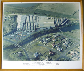 Warrnambool and District Historical Society Inc.
Photograph - Framed aerial photograph of Warrnambool Woollen Mill, Circa 1970
In 1869, the Warrnambool Meat Preserving Company commenced their business on the site, where it operated until 1875 when it was sold to the directors of the Warrnambool Woollen Mill Company. After being destroyed by fire in 1882 it wasn’t until 1910 that the Warrnambool Chamber of Commerce was approached by Marcus Saltau and Peter McGennan to invest in a new mill. The original directors were James Dickson, P J McGennan, Robert Swinton, M Saltau, and J W Younger. In 1955 the Warrnambool Woollen Mill formed a partnership with the Wangaratta Woollen Mills. Dunlop bought the mill in 1968. From that time until its closure in 2000 it had a number of different owners, the last being the Smith Family Industries. The Mill site holds significance for Warrnambool as the site was one of the earliest industries established in the town. The Warrnambool Woollen Mill operated for close to 100 years and in that time forged a strong link with the people of Warrnambool. Its product held a significant position in the marketplace.Aerial colour photograph of the Warrnambool Woollen Mill and surrounding area including carparks. The Merri River crosses from lower left to upper right. Playing field, Jetty Flat, in upper right hand corner and Harris Street bridge in lower left. Aspect is looking easterly. Photo glued to white card mount with text in black underneath. Timber frameWarrnambool Woollen Mill A division of Dunlop Olympic Limited. Manufacturers of Warrnambool/Dreamspun blankets, rugs and fabrics. Registered office South Warrnambool, Victoria. 3280. Australia. P.O. Box 484 Telephone (055)624166. Telex 55820warrnambool, warrnambool woollen mill, woollen mill, dunlop olympic, marcus saltau, p j mcgennan, james dickson, robert swinton, j w younger, dreamspun