Showing 14054 items matching "snowy-river-bridge"
-
 Warrnambool and District Historical Society Inc.
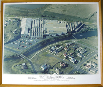
Photograph - Framed aerial photograph of Warrnambool Woollen Mill, Circa 1970
In 1869, the Warrnambool Meat Preserving Company commenced their business on the site, where it operated until 1875 when it was sold to the directors of the Warrnambool Woollen Mill Company. After being destroyed by fire in 1882 it wasn’t until 1910 that the Warrnambool Chamber of Commerce was approached by Marcus Saltau and Peter McGennan to invest in a new mill. The original directors were James Dickson, P J McGennan, Robert Swinton, M Saltau, and J W Younger. In 1955 the Warrnambool Woollen Mill formed a partnership with the Wangaratta Woollen Mills. Dunlop bought the mill in 1968. From that time until its closure in 2000 it had a number of different owners, the last being the Smith Family Industries. The Mill site holds significance for Warrnambool as the site was one of the earliest industries established in the town. The Warrnambool Woollen Mill operated for close to 100 years and in that time forged a strong link with the people of Warrnambool. Its product held a significant position in the marketplace.Aerial colour photograph of the Warrnambool Woollen Mill and surrounding area including carparks. The Merri River crosses from lower left to upper right. Playing field, Jetty Flat, in upper right hand corner and Harris Street bridge in lower left. Aspect is looking easterly. Photo glued to white card mount with text in black underneath. Timber frameWarrnambool Woollen Mill A division of Dunlop Olympic Limited. Manufacturers of Warrnambool/Dreamspun blankets, rugs and fabrics. Registered office South Warrnambool, Victoria. 3280. Australia. P.O. Box 484 Telephone (055)624166. Telex 55820warrnambool, warrnambool woollen mill, woollen mill, dunlop olympic, marcus saltau, p j mcgennan, james dickson, robert swinton, j w younger, dreamspun -
 Kew Historical Society Inc
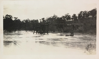
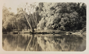
Photograph - Flood, Zig-Zag, Kew, 1924
Henry Beater Christian (1886-1962) , was a descendant of one of the earliest settler families in Kew. Employed at the Kew Asylum as a 'public servant', he was a skilled amateur photographer, photographing numerous scenes in Kew and on his travels around Victoria. The majority of his photographs date from 1916 to 1929. His finest photographs are housed in two photograph albums. Digital copy of a photograph from page 5 of the 47-page photograph album containing 261 gelatinous silver images, loaned by Diane Washfold with permission given to digitise and hold a copy in our collection. This is a photograph of the Zig-Zag Bridge that crossed the river at Kew during a flood in January 1924. The contrast in the photo is compromised because of the weather conditions and due to shooting into the light."Flood / Zig-Zag Kew / 1.24"henry beater christian (1886-1962), landscape photography, kew (vic.) — yarra river, christian-washfold collection, photograph albums, floods -- yarra river -- kew (vic.), zig-zag bridge -
 Melbourne Tram Museum
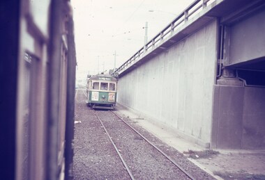
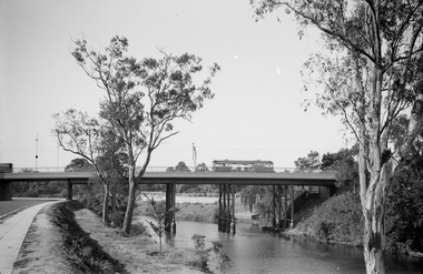
Slide, Keith Caldwell, Mar. 1968
Agfa colour slide, blue / white plastic mount, photo by Keith Caldwell of a view from a tram southbound in Kingsway section where the road bridge starts to rise to cross over the tram track and then the Yarra river. Tram 802, West Coburg - via William St, route 55 is in the view. Tram has adverts for Tolley's Brandy and ? in Essendon. 3/1968In ink "St K jct 3/68"trams, tramways, kingsway, bridges, route 55, west coburg, tram 802 -
 Charlton Golden Grains Museum Inc
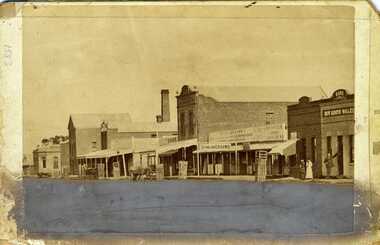
Photograph, Procter, Chris, Charlton High Street c.1883, c.1883
Photograph of western end of High Street, Charlton showing the Bank of Victoria, Malcolm's Flour Mill, Egan's, Golden Fleece Hotel, Johnson's Bridge Store, Dining Rooms and the Bank of New South Wales. c. 1883Early photo of High St, western end streetscapeSepia photograph of western end of High Street, Charlton showing the Bank of Victoria, Malcolm's Flour Mill, Egan's, Golden Fleece Hotel, Johnson's Bridge Store, Dining Rooms and the Bank of New South Wales. c. 1883. Man standing in front of the Bank, two ladies also standing on the footpath. Horse and cart in front of Johnson's store. Damage to the lower third of photo.bank of victoria, malcolm's flour mill, egan's, golden fleece hotel, johnson's bridge store, dining rooms, bank of new south wales, high street, business -
 Kew Historical Society Inc
Photograph - Macauley's, Kew, 1924
Henry Beater Christian (1886-1962) , was a descendant of one of the earliest settler families in Kew. Employed at the Kew Asylum as a 'public servant', he was a skilled amateur photographer, photographing numerous scenes in Kew and on his travels around Victoria. The majority of his photographs date from 1916 to 1929. His finest photographs are housed in two photograph albums. A fine, early view of Macauley's boat sheds on the Yarra River at Kew.Digital copy of a photograph from page 2 of the 47-page photograph album containing 261 gelatinous silver images, loaned by Diane Washfold with permission given to digitise and hold a copy in our collection. The photograph is of Macauley's boat sheds on the Yarra River at Kew. The boat sheds were located at the west end of Molesworth Street. The photograph is taken from the Yarra Bend Park side of the river, or from a boat on the river. The canoes belonging to Macauley's are lined up on the river bank. "Macauley’s Kew"henry beater christian (1886-1962), landscape photography, kew (vic.) — yarra river, christian-washfold collection, photograph albums, macauley's boat sheds -
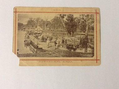 Port of Echuca
Photograph (sepia), approx 1850's
Sepia photograph of Hopwood's Punt, showing the gangway extended to river bank. There are 5 workmen, dressed in work clothes and boots, at the front of the punt and 2 gentlemen, dressed in coats and umbrellas. Stock, produce (possibly wool bales) and people are on board. There are 3 horses hitched to a wagon and behind there looks like a large consignment of wool bales. There appears to be women at the side of the punt (1 with an umbrella up). At the side of the punt there appears to be a passenger landing. There is also a small row boat tied to the side of the punt. Wagons, barge and possibly other punts are in the background. There was a painting of this scene by J. C. Armytage around 1857.This is a very good example of the cargo, people, produce and animals, that were using the punt to cross the Murray river in the late 1800s. The difference between workers and gentry can be seen as well as the modes of transport at this time.Sepia photograph of Hopwood's Punt, showing the gangway extended to river bank. Stock, produce (possibly wool bales) and people are on board. Wagons, barge and possibly other punts are in the background. Mounted on buff cardboard printed with red lines and letters.On the front at the top, above the red boarder "Royal", at the bottom below the red boarder "Hopwood's Punt, Echuca". On the reverse, "W. B. Payne, Darling St., Echuca"murray river, echuca, hopwood's punt, j. c. armytage (painter) -
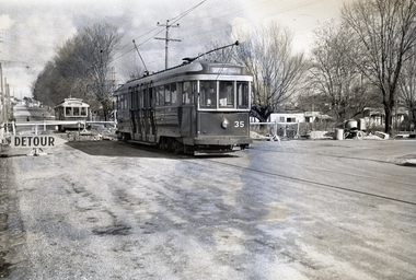 Ballarat Tramway Museum
Negative, Wal Jack, Jul. 1955
Yields information about tram services during the reconstruction of the Canadian Creek bridge on the Mt Pleasant line during 1955.Negative and Digital images of the Wal Jack Ballarat Negative file of No. 35 at the Barkly St bridge work at Canadian Creek bridge in Barkly St, Mt Pleasant during the reconstruction of the bridge, during June-July 1955, Has No. 35 providing the connecting service to the City and Drummond St North. No. 32 waits on the other side of the bridge. See Reg items 5157 and 5305 for other associated photos.trams, tramways, mt pleasant, canadian creek, barkly st, bridges, tram 32 tram 35 -
 Eltham District Historical Society Inc
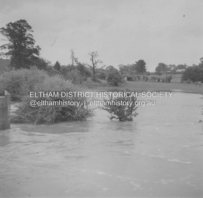
Album - Photograph, J.A. McDonald, Eltham-Greensborough Road, 18 Oct. 1956
Bridge Street Bridge Flooding on Hill’s property 18th October 1956 This view is looking west north west from the Bridge Street Bridge across the present day Eltham Skatepark. The shed visibile in the distance is directly opposite Brisbane Street where it used to run into Susan Street but now turns the corner. To the right of the shes is the site for present-dayHarris Plumbing which was formerly occupied by Sibbel Builders; to the left the site now occupied by Bunnings. At the skyline to the right of centreeline is a gap in the trees where the railway line runs. The Silver Street bridge over the railway is visible. Beware!.. our rivers are rising (1956, October 19). The Argus (Melbourne, Vic. : 1848 - 1957), p. 1. Retrieved August 24, 2022, from http://nla.gov.au/nla.news-article84392304Record of various Shire of Eltham infrastructure works undertaken during the period of 1952-1962 involving bridge and road reconstruction projects, sometimes with Eltham Shire Council Project Reference numbers quoted. It was during this period that a number of significant improvements were made to roads and new bridges constructed within the shire that remain in place as of present day (2022). In many situations, the photos provide a tangible visible record of infrastructure that existed throughout the early days of the Shire. The album was put together by or under the direction of the Shire Engineer, J.A. McDonald.infrastructure, road construction, shire of eltham, bridge construction, bridge street bridge, eltham, eltham-greensborough road, 1956-10-18, diamond creek (creek), floods, floodwater, hill property, silver street bridge -
 Lakes Entrance Historical Society
Book, Dept of Natural Resources and Environment Victoria Publisher, Heritage Rivers and Natural Catchment Areas Vol 3, 1997
Draft Management Plans prepared under the Heritage Rivers Act set out the proposed basis for future management of Heritage Rivers and Natural Catchment Areas. Gippsland catchments are significant for the essential undisturbed conditionISBN 0730667936environment, waterways -
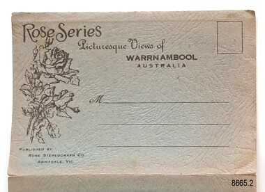 Flagstaff Hill Maritime Museum and Village
Postcard - Postcard Folder, scenes, George Rose, Rose Stereographic Company, Rose Series, Picturesque Views of Warrnambool Australia, 1880-1942
GEORGE ROSE 1861-1942: - George Rose was a well-known Victorian photographer, famous for his late 19th and early 20th century photography. He was born in Clunes, Victoria, and was in his 20th year when he founded Rose Stereograph Company in 1880. He took the opportunity of a popular trend of the times to produce stereographs, pairs of almost duplicate photographs that appeared in 3D when viewed in a handheld stereo viewer. By the 1920s, these lost their popularity, so he used his photographic skills to produce cards and postcards of scenes and people. The twelve photographs in the Rose postcard folders include locations connected to other items in our Collection, including the Valentine postcard folder in this set. The photographs are titled: - . The Avenue and War Memorial. Warrnambool. Vic. . The Blow-hole. Thunder Point. Warrnambool. Vic. . Botanical Gardens. Warrnambool. Vic. . Eagle Rock. Warrnambool. Vic. . The New Concrete Bridge and Breakwater. Warrnambool. Vic. . Liebig Street. Warrnambool. Vic. . Looking to Thunder Point. Warrnambool. Vic. . The Beach. Warrnambool. Vic. . Hopkins Falls. Warrnambool. Vic. . Shelly Beach. Warrnambool. Vic. . The Mouth of the Hopkins River. Warrnambool. Vic. . Panorama of Warrnambool, Vic. [Kepler Street towards Presbyterian Church on Spence St] This postcard folder shows scenes and places of interest in and around Warrnambool. The George Rose postcard folders in this set were produced in Victoria and include pictures taken by the renowned photographer between 1880 and 1942. Other postcards in our collection have photographs of the same or similar locations at different periods in time. Each postcard records a moment in history and is significant as a way to compare and show the changes in the local environment and community, building a story of the local history. The images record changes in the coastline, land, bay, buildings and other structures, roads, transportation and even the fashions of the times. This copy folder is one of a set of three. This folder has a green-grey textured rectangular card cover with a sketch of a rose on the front. The cover also contains the name of the postcard series, the location of the series' focus, the producer's details, and lines for adding an address. The folded cover contains a long, concertinaed page with six titled photographs on each side, totalling twelve. The folder contains scenes from Warrnambool and nearby popular areas, including Lady Bay, the Port of Warrnambool, the Warrnambool Breakwater, the Viaduct, the Merri River Footbridge, the Hopkins River Mouth, and Proudfoot’s and the Fanny Nelson/Flett boathouses. The cover has a sketch of a rose and inscriptions. The lithograph photographs were taken between 1880 and 1942 by well-known Victorian photographer George Rose, Rose Stereograph Company of Armadale, Victoria.Image: [Rose with rosebud and leaves] Printed: "Rose Series / Picturesque Views of / WARRNAMBOOL / AUSTRALIA" "PUBLISHED BY / ROSE STEREOGRAPH CO / ARMADALE. VIC."flagstaff hill maritime museum and village, great ocean road, shipwreck coast, warrnambool, flagstaff hill, flagstaff hill maritime museum, flagstaff hill maritime village, warramble, postcard, postcard folder, warrnambool scenes, picturesque views of warrnambool, lady bay, port of warrnambool, breakwater, warrnambool breakwater, viaduct, merri river footbridge, merri river suspension bridge, suspension footbridge, merri river mouth, hopkins river mouth, proudfoot's, fanny nelson, nelson's boatsheds, nelson's boathouse, boathouse, hopkins river boathouses, flett's boathouse, flett, george rose, image of a rose, rose series, rose stereograph co, rose stereographic company, lighograph, armadale victoria, lady bay beach, beach scene, lower light, concrete footbridge, 1922 footbridge, viaduct road, rose postcard, new concrete bridge, 1945, 1890, 1922, small footbridge, 1872 footbridge, 1872, merri river estuary, stingray bay, postcards, green-grey postcard folder, shipwrecked coast, maritime museum, souvenir, warrnambool local scenes, photography, local history, tourism, photographs, visitors, travel, scenes, mid-20th century, 1940s, 1950s, concertina fold, z-fold, 1880s, collection, correspondence, rose stereograph co armadale, victorian photographer, soldiers’ memorial, hopkins river, the cliffs at shelly beach, the road to sandy beach, pier, botanic gardens, post office, municipal buildings, merri river, proudfoot’s -
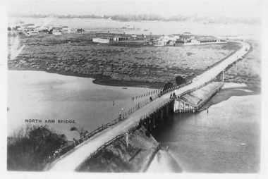 Lakes Entrance Historical Society
Photograph - Aerial view of North Arm Bridge, 1930c
Black and white photograph concrete bridge over North Arm, two people at southern end of bridge, swampy area approaching Club Hotel. Lakes Entrance Victoriabridges, township -
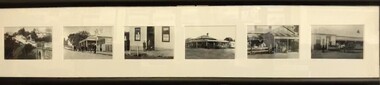 Greensborough Historical Society
Postcards (framed), Greensborough Historical Society, Greensborough Historical Society Postcards. Series One, 2011_08
Set of 6 postcards produced for sale by Greensborough Historical Society. Postcards Left to right: Plenty River Bridge; Quirk's Tea Rooms; Commercial Bank; Farmer's Arms Hotel, all Main Street; Medhurst Fruit Store, and, Greensborough Hotel, Grimshaw Street.6 black and white postcards in black timber frame, under glass.greensborough historical society, main street greensborough, grimshaw street greensborough -
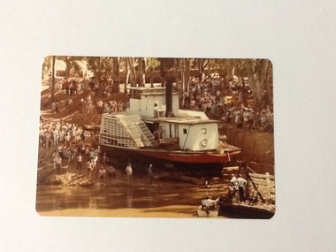 Port of Echuca
Colour Photograph, 04/03/1983
This coloured photograph shows the re-floating of the P. S. Adelaide on a soil ramp, being encouraged (rear entry) down the temporary slipway onto the river. The temporary slipway is clearly visible with a workman (possibly Kevin Hutchinson) standing at thelast log as the boat nears the waters' edge. A winching float and an outboard motor boat are at the right. Spectators line the banks of the ramp. Part of a photo sequence no.P000041; P000045; P000046; P000047; P000048 of P. S. Adelaide re-floating.The re-floating of the P. S. Adelaide was a Significant community social event evident by the number of spectators in the photograph. The community had invested a great deal of time and money into re-floating the paddlesteamer. The newspaper covered the event in detail with a number of action shots as the boat made its rear entry from the temporary slipway onto the river. Part of a photo sequence no.P000041; P000045; P000046; P000047; P000048 of P. S. Adelaide re-floating.Colour photograph of the P. S. Adelaide on a soil ramp, being encouraged (rear entry) onto the river. A winching float and an outboard motor boat are at the right front. Spectators line the banks of the ramp. Temporary slipway constructed of logs is clearly visible before the boat enters the water. -
 Kew Historical Society Inc
Photograph - Flooding of the Yarra River in North Kew, 1934
North Kew, now divided between Kew and Kew East, bordered the Yarra River. As such, it was a region subject to flooding in the Yarra Valley. Development beyond this point (ie Kellett Grove) was limited by the City of Kew's planning regulations. Prior to urban development, the area since European settlement and the first land sales in the district in the 1840s, had been used for dairy farming. Small sepia snapshot of floodwaters taken from near Willsmere Road, in what was then known as North Kew. The point of view is looking towards Fairfield. In the foreground are two figures viewing a group in a rowboat in the middle of the flooded river. Semi-submerged street lighting indicates that entire streets had been. overwhelmed by the flood waters. Verso: WILLSMERE ROAD NORTH KEW / Stamped 3 163yarra river -- north kew, floods -- yarra valley, floods -- north kew, floods -- 1934, natural disasters -- kew, willsmere road -
 Orbost & District Historical Society
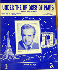
sheet music, Under the Bridges of Paris, first half 20th century
Under the Bridges of Paris" is a 1913 popular song with music written by Vincent Scotto, the original French lyrics (entitled "Sous les ponts de Paris") by Jean Rodor (1913), and English sections of lyrics added by Dorcas Cochran (1952) resulting in the released version (1954) containing both French and English sections. This version of the song was recorded by Rene Paul.The music has social significance as an example of music popular in the first half of the 20th century.Sheet music for "Under the bridges of Paris". The cover is blue with white illustrations of the Eiffel Tower and the Arc de Triomphe. In the centre is a head and shoulders photograph of a man in a suit and tie. It is captioned "Recorded by Rene Paul on Columbia." Under the title are details of the composer and lyricists. In the bottom right corner is the price 2/6.music-sheet under-the-bridges-of-paris -
 Kew Historical Society Inc
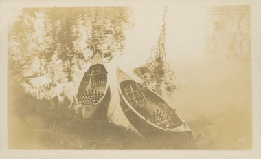
Photograph - Victorian Canoe Club, Nagha & Dunapna completed completed, 1920-30
Canoeing on the River Yarra at Melbourne was an important and widespread recreational pursuit for Melbournians, especially in the first half of the twentieth century. The Victorian Canoe Club was formed in 1912 at a meeting in Melbourne and its first committee elected in the same year. Records indicate that the Club continued into at least the 1950s .The album has historic and social significance as a record of recreational activities (as well as canoe making) in the early years of the twentieth century. It has local significance as the site of the headquarters of the Club was in Studley park. A number of photographs in the album provide vistas of Kew on the Yarra that are otherwise unavailable.One of 24 labelled photos in part album, originating from the Victorian Canoe Club, which had its headquarters in Studley Park, Kew. The album includes a photographic record of canoe construction and also locations in Studley Park and Kew where the canoes were used. The subject of this photograph is identified as 'Nagha & Dunapna completed' with an overhead view of two named canoes on the banks of the Yarra River."Nagha & Dunapna completed"victorian canoe club, canoe making, river yarra, burke road, mornington, studley park, kew, steaming gear, canoe construction -
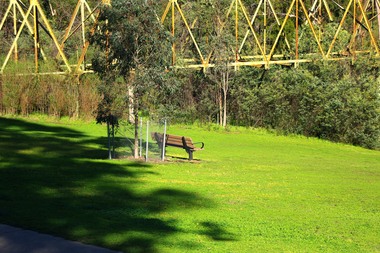 Greensborough Historical Society
Photograph - Digital Image, Marilyn Smith, The Separation Tree Greensborough 2019, 02/07/2019
The original Separation Tree was one of two red river gums that pre-dated European occupation, and was the site where colonists congregated to celebrate the announcement of Victoria's separation from New South Wales on 15 November 1850. It died as the result of vandalism in 2010 and 2013. Saplings of the original were planted around Melbourne in 2014, including this one along the Plenty River Trail in Greensborough. The old aqueduct bridge can be seen in background.2 colour digital photographsseparation tree, plenty river trail, aqueduct pipe bridge greensborough -
 Kew Historical Society Inc
Photograph - Flooding of the Yarra Valley at Kew East, 1974
Flooding of the Yarra Valley, including that section of the Yarra bordering Kew and Kew East in the north and west of the municipality, was a regular occurrence. Extreme flood events of the Yarra River are recorded to have occurred in 1891, 1901, 1916, 1923 and 1934. The Municipality of Kew's response to these floods was to enact planning decisions restricting residential development in flood prone areas following the floods of 1916, 1921 and 1934. While floods continued after the development of the Upper Yarra Reservoir (construction 1948-57), the regularity and extent of these inundations diminished. During the nineteenth century, the land abutting the south side of the Yarra in Kew was devoted to dairy farming. In the twentieth century, before and after the construction of the Eastern Freeway, much of this low-lying area was used as golf courses and public parks.Late example of the capacity of the Yarra Valley at Kew to flood, even though drainage works and the Upper Yarra Reservoir had reduced their regularity.Original black and white print photograph of Hay's Paddock under floodwater on 16 May 1974. The vantage point of the photographer is Keystone Crescent looking east. Flooding was caused by overflowing water in Glass' Creek and the River Yarra. Annotation verso: "Keystone Cr looking east / 16 May 1974 11.50am"hays paddock, floods, yarra river, glass' creek -
Glenelg Shire Council Cultural Collection
Print - Contact Print - Pastoral Scene, 1960-1970
Sheet of 2 contact prints from glass plate negatives. Top: 2 men and 2 women in a clinker built dinghy on a river. Beds of reeds in river. River bank heavily wooded. Bottom: 3 women, one seated in garden at 'Beechwood', Dutton Way. People in both prints dressed in fashion late 19th, early 20th century. -
 Kew Historical Society Inc
Photograph - Construction of the Eastern Freeway (F19), Ron Setford, March 1972
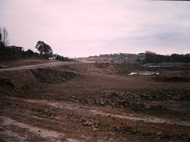
Ron Setford and his wife Grace Setford lived in Tanner Avenue, East Kew, from c.1946 to c.1995. A keen photographer, he recorded the changing face of Kew over a 20 year period. Apart from 30 photographs of built structures and places in Kew dating from 1960 and 1961, 145 of his 35mm colour slides chronicle the development of the F19 (later renamed Eastern) Freeway through the Yarra Valley in Kew over a five year period from c.1972 to c.1977. This important collection was donated to the Society by his granddaughter in 2025.This collection of 175 35mm slides is of local and statewide significance, owing to its subject matter, particularly the major development of road transport infrastructure during the 1970s with the construction of the Eastern Freeway. The photographer also took care to annotate and date most of his slides which enable the researcher to pinpoint temporal and spatial locations."Eastern Freeway 6/72 / Rock fill in old river bed"ron setford, eastern freeway, f19 freeway -
 Kew Historical Society Inc
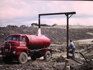
Photograph - Construction of the F19 [Eastern Freeway], Ron Setford, ca. 1973
Ron Setford and his wife Grace Setford lived in Tanner Avenue, East Kew, from c.1946 to c.1995. A keen photographer, he recorded the changing face of Kew over a 20 year period. Apart from 30 photographs of built structures and places in Kew dating from 1960 and 1961, 145 of his 35mm colour slides chronicle the development of the F19 (later renamed Eastern) Freeway through the Yarra Valley in Kew over a five year period from c.1972 to c.1977. This important collection was donated to the Society by his granddaughter in 2025.This collection of 175 35mm slides is of local and statewide significance, owing to its subject matter, particularly the major development of road transport infrastructure during the 1970s with the construction of the Eastern Freeway. The photographer also took care to annotate and date most of his slides which enable the researcher to pinpoint temporal and spatial locations."Eastern Freeway / Filling water tanker from river / 5/73"ron setford, eastern freeway, f19 freeway -
 Bendigo Historical Society Inc.
Document - COHN BROTHERS COLLECTION: LANEWAY DOCUMENT, 1959
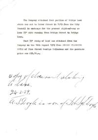
Document relating to a transfer of part of Bridge Lane and a 33' wide laneway between Bridge St. and Bridge Lane. The 33' strip of land was obtained from Andrew Sylvester Doyle of Finn St. Bendigo, Cellarman. Written in ink at the bottom is ' copy of document relating to lane 24/2/1959'organization, business, land transfer, cohn brothers , bridge street , bridge lane, andrew sylvester doyle -
 Melbourne Tram Museum
Negative - Set of 2, Ellis Collection, c1940?
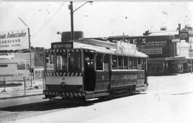
Set of two Negatives (120) of a wide body car crossing the Wallen St Road Bridge Hawthorn possibly after the construction of The Boulevard. Taken from either side of the river. Hi Res image filed in the dbtext/hawthtramcoll/Large Images/htd3595aLarge.jpg and htd3595bLarge A low resolution A4 laminated was received with the negatives. Image i2 - taken from Glan Avon Rd in Hawthorn of Wallen Rd bridge – the tram is one of three SW2 class trams (not the first one due to the door sizes, but one of 426, 432 or 478, most probably 478 as that was a Camberwell car)trams, tramways, wallen rd, bridges, sw2 class -
 Greensborough Historical Society
Photograph - Digital image, George Stock and family 1909, 1909_
George Stock and family 1909 (left to right) Jane Finn and son George, George William Stock. House in Main Street near bridge over river. Photographs from the collection of Peter Blackbourn, a descendant of the Chapman Stock family. Annotations to photos by Peter Blackbourn.Digital copy of black and white photograph.peter blackbourn, george willam stock, jane stock (nee finn), george stock -
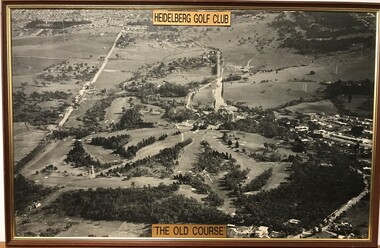 Heidelberg Golf Club
Photograph - Framed Photograph, Heidelberg Golf Club: The old course, 1966c
An aerial photograph of the Heidelberg Golf Course, around 1966 (this date is taken from the road work to build the new bridge over the Plenty River). Known as the 'old course' it was designed by Harry Alexander and was in play until a redesign of the course in 1968. The clubhouse is in top centre of photograph.One of several aerial photogrphs showing the layout of the Heidelberg Golf CourseLarge Black and white aerial photograph, timber frame. Brass plaque top and bottom."Heidelberg Golf Club" "The old course"heidelberg golf club, old course -
 Federation University Historical Collection
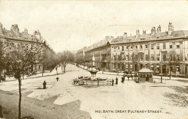
Postcard - black and white, Great Pulteney Street, Bath
Great Pulteney Street is a grand thoroughfare that connects Bathwick on the east of the River Avon with the City of Bath, England via the Robert Adam designed Pulteney Bridge. Famous former residents of the street have included the novelist Jane Austen and the anti-slavery campaigner William Wilberforce.A black and white postcard showing Great Pulteney Street in Bath. The street is lined with triple storey building. A fountain and small shelter is located in the foreground.This card was purchased by an Australian soldier, probably Henry Smerdon Holmes, during World War One. chatham-holmes family collection, bath, gret pulteney street, fountain -
 Ballarat Tramway Museum
Photograph - Black & White Photograph/s, David Clark, 17/02/1971 12:00:00 AM
Yields information about the Ballarat's tramcars in the months before closure and the appearance then of Stones Corner.Black and white photograph of Ballarat No. 21 in Victoria St, looking back to Stones Corner building. Photo by David Clark 17/2/1971. Tram has just left Bridge St. Stones Corner building in the background, and Viscount Ambassador Caravans to the left of the tram having replaced the Caltex Service Station on this location. Tram has the destination of Victoria St.On the rear in ink "Tram No. 21 in Victoria St, near Bridge St, looking to Sturt St. 17/2/71. Ballarat Tramways, Photo 30, Taken by David Clark", with David's address stamp "4 Adeney Ave Kew 3101" with "Melbourne" underneath.tramways, trams, victoria st, stones corner, bridge st, tram 21 -
 Phillip Island and District Historical Society Inc.
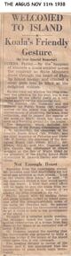
Newspaper clippings, 11/11/1938
Article in The Argus newspaperArticle on visit of the Premier, Mr Dunstan, to Phillip Island to discuss preservation of the Koala and the prospect of a bridge between San Remo and Newhaven. At a meeting with residents it was agreed the bridge should be built.local history, documents, newspapers, bridges, phillip island, koalas, black & white newspaper clipping -
Glenelg Shire Council Cultural Collection
Negative - Glass Plate Negative - Botanic Gardens, c. 1890
Glass plate negative. Image shows 3 young women on bridge in Botanic Gardens - one of the bridges linking the islands. Dress estimated to be late 19th, early 20th Century. -
Port Melbourne Historical & Preservation Society
Photograph - Centenary Bridge prior to complete demolition, Pat Grainger, 1988 - 1991
11 colour photographs taken from various locations of the Centenary Bridge prior to complete demolition in 1991 One B&W photo of the staircase on the West side of the Centenary Bridgecentenary bridge, demolitions, built environment, town planning - proposals shelved - bayside