Showing 180139 items
matching streets
-
 Wodonga & District Historical Society Inc
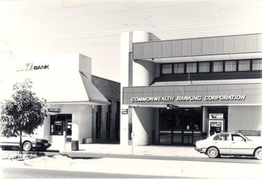
Photograph - Codling Collection 01 - High Street East - ANZ Bank, Commonwealth Banking Corporation, 1980s
Miss Olive Codling was a Foundation Member and a Life Member of the Wodonga Historical Society. Many of her prize-winning photos are held in the Society Collection. She also held a range of roles and committee positions in a wide range of Wodonga community organisations. These included the Horticultural Society, the Wodonga Arts Council, the Wodonga Camera Club and the Wodonga Lapidary Club. This photo collection is significant as it documents how the businesses and buildings in Wodonga have evolved and contributed to community throughout the 20th century.Eastern side of High Street, Wodonga - High Street East - ANZ Bank, Commonwealth Banking Corporation. Both of these banks have now moved to the opposite side of High Street as part of the redevelopment of the city centre. At the time of this entry in 2021 the Commonwealth Bank pictured is the office of Senator The Hon. Bridget McKenzie and the ANZ Bank building is vacant.wodonga businesses, high st wodonga, commonwealth bank wodonga, anz bank wodonga -
 Kew Historical Society Inc
Plan, Melbourne & Metropolitan Board of Works : Borough of Kew : Detail Plan No.1561, 1905
The Melbourne and Metropolitan Board of Works (MMBW) plans were produced from the 1890s to the 1950s. They were crucial to the design and development of Melbourne's sewerage and drainage system. The plans, at a scale of 40 feet to 1 inch (1:480), provide a detailed historical record of Melbourne streetscapes and environmental features. Each plan covers one or two street blocks (roughly six streets), showing details of buildings, including garden layouts and ownership boundaries, and features such as laneways, drains, bridges, parks, municipal boundaries and other prominent landmarks as they existed at the time each plan was produced. (Source: State Library of Victoria). This plan forms part of a large group of MMBW plans and maps that was donated to the Society by Mr Poulter, City Engineer of the City of Kew in 1989. Within this collection, thirty-five hand-coloured plans, backed with linen, are of statewide significance as they include annotations that provide details of construction materials used in buildings in the first decade of the 20th century as well as additional information about land ownership and usage. The copies in the Public Record Office Victoria and the State Library of Victoria are monochrome versions which do not denote building materials so that the maps in this collection are invaluable and unique tools for researchers and heritage consultants. A number of the plans are not held in the collection of the State Library of Victoria so they have the additional attribute of rarity.Original survey plan, issued by the MMBW to a contractor with responsibility for constructing sewers in the area identified on the plan within the Borough of Kew. The plan was at some stage hand-coloured, possibly by the contractor, but more likely by officers working in the Engineering Department of the Borough and later Town, then City of Kew. The hand-coloured sections of buildings on the plan were used to denote masonry or brick constructions (pink), weatherboard constructions (yellow), and public buildings (grey). MMBW Detail Plan 1561 outlines those residences in the area bordered by Burke Road, Loxton Street, Mount Street and Barkers Road that had been constructed by 1905 when the land was surveyed. At this time, the area nearest Burke Road had been subdivided and developed whereas the lands to the west were as yet undeveloped. The houses represented are not named on the Plan.melbourne and metropolitan board of works, detail plans, mmbw 1561, cartography -
 Eltham District Historical Society Inc
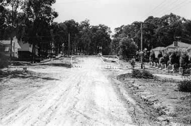
Photograph, Bridge Street, Eltham, c. Sep. 1966
Last house on right is No. 122. The three houses on right remain relatively original in present time, the two visible houses on left have been substantially altered or replaced. Bridge Street ended at this point but has since been further extended eastBlack and white photographic printOriginally located in a Filmpro King Size Prints processing envelope $3.01 Shire of Eltham 9/9/66 and noted as Calrossie Ave area and crossed out Eltham-Yarra Glen Road, Bridge Street to Elsa Court existing conditions mid 1967eltham, infrastructure, road construction, roads, bridge street -
 Melbourne Athenaeum Archives
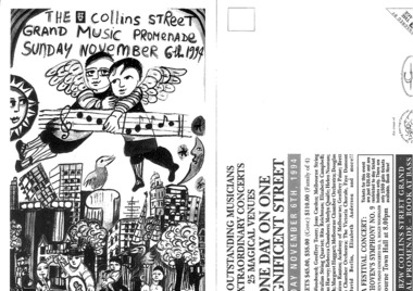
postcard Flyer, The BZW Collins Street Grand Music Promenade (Musical Variety Concert) commencing Sunday November 6th 1994
Concerts were held at ten venues in Collins street grand music promenade venues:Baptist Church, St Michaels, ANZ Cathedral Room, 101 Collins Street, Kay Craddock bookshop, Georges Dining Room, Scot's Church, 161 Collins Street, the gold vaults of the Old Treasury Building. Note: It was recorded in the secretary's diary that concerts associated with the Collins Street Grand Music Promenade were held at the Melbourne Athenaeum Theatre all day on Sunday the 6th of November. This festival was organised by Greg Hocking and Peter Marks.Black and white postcard flyer Folder also contains a newspaper article, a venue program, folded poster and various letters of correspondence. One day on a magnificent street with: Roger Woodward, Geoffrey Tozer, Joan Carden, Melbourne String Quartet, Rita Reichman, Australian String Quartet, Elizabeth Campbell, Micheal Kieran Harvey,Rebecca Chambers, Merlyn Quaife, Helen Noonan, Jeannie Marsh, Margaret Haggart, Melbourne Chamber Orchestra, Douglas Lawrence, Spiros Rantos, Academy of Melbourne, Geofrey Paine, Brett Kelly, Haydn Chamber Orchestra, The Victorian Chorale, Faye Dumont Singers, David Berlin, Elizabeth Anderson and more ...the collins street grand music promenade, melbourne athenaem theatre -
 Kew Historical Society Inc
Plan, Melbourne & Metropolitan Board of Works : Borough of Kew : Detail Plan No.1569, 1905
The Melbourne and Metropolitan Board of Works (MMBW) plans were produced from the 1890s to the 1950s. They were crucial to the design and development of Melbourne's sewerage and drainage system. The plans, at a scale of 40 feet to 1 inch (1:480), provide a detailed historical record of Melbourne streetscapes and environmental features. Each plan covers one or two street blocks (roughly six streets), showing details of buildings, including garden layouts and ownership boundaries, and features such as laneways, drains, bridges, parks, municipal boundaries and other prominent landmarks as they existed at the time each plan was produced. (Source: State Library of Victoria)This plan forms part of a large group of MMBW plans and maps that was donated to the Society by the Mr Poulter, City Engineer of the City of Kew in 1989. Within this collection, thirty-five hand-coloured plans, backed with linen, are of statewide significance as they include annotations that provide details of construction materials used in buildings in the first decade of the 20th century as well as additional information about land ownership and usage. The copies in the Public Record Office Victoria and the State Library of Victoria are monochrome versions which do not denote building materials so that the maps in this collection are invaluable and unique tools for researchers and heritage consultants. A number of the plans are not held in the collection of the State Library of Victoria so they have the additional attribute of rarity.Original survey plan, issued by the MMBW to a contractor with responsibility for constructing sewers in the area identified on the plan within the Borough of Kew. The plan was at some stage hand-coloured, possibly by the contractor, but more likely by officers working in the Engineering Department of the Borough and later Town, then City of Kew. The hand-coloured sections of buildings on the plan were used to denote masonry or brick constructions (pink), weatherboard constructions (yellow), and public buildings (grey). This plan covers parts of Sackville Street, John Street, Thomas Street and Cotham Road, and includes several very large houses in Sackville Street. Job Smith built ‘Berrington’ in about 1888-90 for himself, and ‘Pomeroy’ (now ‘Merridale’) in 1885 for James Mickleburgh. ‘Heathfield’ was built in 1888 for Henry Eeles, and was one of many fine homes in Kew, Hawthorn and surrounding suburbs designed by prolific architect John Beswicke; it later became “La Verna” and was a Franciscan monastery. Similarly, in Cotham Road, we can see ‘Bella Vista’ (now demolished), and ‘Charleville’, with its double-storeyed arcade frontage, built in 1889 for Charles Donaldson whose family occupied it until 1939. This was renamed ‘Ross House’ by the second owner, Dr. Thomas King, and then substantially restored in the 1960s by the Stillwell family, well known as car drivers and dealers. Bella Vista (later ‘Malinda’) was originally designed by the architect Robert Haddon and built for Abel Hoadley, inventor of the Violet Crumble Bar and many other delicious delicacies. He began by manufacturing jams and pickles in South Melbourne using fruit from his own orchard in East Burwood.melbourne and metropolitan board of works, detail plans, mmbw 1569, cartography -
 Port of Echuca
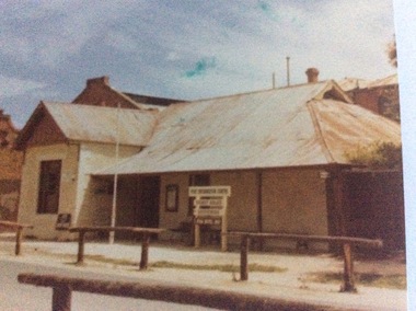
Colour photograph, 1979
The Star Hotel was built in 1863 as a private dwelling, by James Shackell who owned the Bond Store, next door. It was a small house consisting of only a couple of rooms. In 1867 Joseph Salomon bought the house and converted it into a hotel. He built an underground bar to "deal with the peculiarities of the Echuca climate". It was called 'The Shades'. In 1890 Jane Pygall bought the hotel, which was described by the Riverine Herald as having ' three parlours, seven bedrooms, underground bar, kitchen, bathroom, outhouses, small stables, and entrance from two streets." She changed the name to The Esplanade Hotel. In 1890 it was de-licensed along with many hotels in Echuca. It had been a very popular drinking place for all the wharf workers, who continued to to drink illegally in the underground bar. It was then that the escape tunnel to the laneway was built , so the drinkers could escape the Police raids. For many years it was a private dwelling, or an office. In 1973 the City of Echuca bought the Star Hotel and resored it. At the time this photograph was taken it was the main tourist information centre for the Port of Echuca. It now operates as a hotel, serving meals and providing performance opportunities for musicians.The Star Hotel is very significant in Echuca's history due to its proximity to the Echuca Wharf. It was the closest bar to the wharf. Despite Jane Pygall trying to improve the quality of her clientele, the wharf drinkers preferred to drink at The Star Hotel, as the Bridge Hotel catered for more upmarket clientele. After de-licensing in 1897, the workers continued to drink at The Shades Bar and even put in place elaborate strategies to enable them to drink illegally there. It is now a large eating and entertainment site, and the public are still able to visit 'The Shades Bar'.A coloured photograph of the Star Hotel building in Murray Esplanade. The photograph is taken from the east side of the street. The Shackell's Bond Store can be seen on the left of the photograph. Printed on the back are the words, "This paper manufactured by Kodak". Also on the back is green Port of Echuca stamp. Written across the front of the Bond Store are the words 'World In Wax Museum.' On a sign outside the Star Hotel are the words, "Port Information Centre. Ticket Sales. Souvenirs . Star Hotel 1867."port of echuca, star hotel, shackell, james, salomon, joseph, pygall, jane, esplanade hotel, 1863, underground bar, the shades, de-licensing of echuca hotels -
 Bendigo Historical Society Inc.
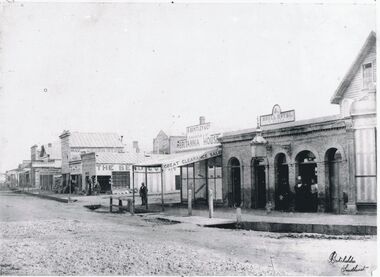
Photograph - CHARING CROSS/FOREST STREET: BENDIGO, 1860's
Black and white photo: copy. Streetscape at Charing Cross - side street is Forest Street, roadway to left of Forest St. is High St. Roadway to right of Forest Street is View Place. . On back 'Batchelder, Sandhurst, lower RH of image, in grey lead top RH on back No. 7 ' Busineses include J.B.Loridan steam chaff mills Hay & Corn Store The Benndigo Tin Shop Forest Street R.Bentley & Co Britannia House Royal Hotel Batchelder PhotoBatchelder Sandhurstplace, streetscape -
 Bendigo Historical Society Inc.
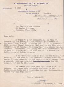
Document - AILEEN AND JOHN ELLISON COLLECTION: LETTER COMMONWEALTH ELECTORAL OFFICE
Letter dated 30th July, 1969 from the Commonwealth of Australia, State of Victoria, electoral office for the division of Bendigo, 45 bull Street, Bendigo addressed to Mr. Leslie John Ellison, 15 Archer Street, Kangaroo Flat, 3555. The letter advise Mister Ellison that due to changes in the federal electoral boundaries Archer Street is now in the Golden Square subdivision but because by-elections must be held on the boundaries of the previous federal election, Archer Street reverted to the subdivision of Marong.government, federal, electoral office -
 Ballarat Tramway Museum
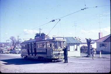
Photograph - Digital image, Joy Waller, 19/09/1971 12:00:00 AM
Copy of a colour slide showing Tram 42 in Lydiard Street North, at the terminus. This photo is taken from the north east looking down Lydiard Street. The conductor is adjusting the trolley pole it is preparing to head back into the city, and the destination board is reading Sebastopol. The shelter at the terminus can be seen, and there is a female passenger in hat and coat walking away from the tram. The photographer says this was taken on the last of the last tram to run in Lydiard Street in 1971. There is another photographer further down the street.trams, tramways, ballarat trams, crews, houses, last day, lydiard st nth, secv tramways, street scene, terminus, tramway closure, maximum traction, tram 42 -
 Bayside Gallery - Bayside City Council Art & Heritage Collection
Photograph, Department of Crown Lands and Survey, Victoria, Melbourne Project: Brighton, 1976
The Department of Crown Lands and Survey (1857-1983) was responsible for the administration of survey and mapping and the sale, occupation and management of crown land throughout its existence. This aerial photograph shows parts of Brighton and was taken on 1 December 1976brighton, department of crown lands and survey, aerial photograph, bayside, port phillip bay, map, cartographic material, melbourne project 1976, brighton yacht club, middle brighton baths, north road, st kilda street, new street -
 Kew Historical Society Inc
Plan - Subdivision Plan, Shop Sites, East Kew, c.1927
Subdivision plans are historically important documents used as evidence of the growth of suburbs in Australia. They frequently provide information about when the land was sold on which a built structure was subsequently constructed as well as evidence relating to surveyors and real estate and financial agents. The numerous subdivision plans in the Kew Historical Society's collection represent working documents, ranging from the initial sketches made in planning a subdivision to printed plans on which auctioneers or agents listed the prices for which individual lots were sold. In a number of cases, the reverse of a subdivision plan in the collection includes a photograph of a house that was also for sale by the agent. These photographs provide significant heritage information relating house design and decoration, fencing and household gardens.This is one of a small number of subdivision plans for commercial property in the collection. The subdivision proposed to create six shop sites in High Street between the Harp of Erin and Station Street. The plan shows this stretch of High Street, East Kew already lined with shops that include the hotel on the corner, the new State Savings Bank, a dentist’s surgery and Lambert’s Store. The High Street Tram was to reach Burke Road in 1925, so the proposed subdivision must postdate that event, and the opening of the Bank in 1926.subdivision plans - east kew, high street - east kew -
 Kew Historical Society Inc
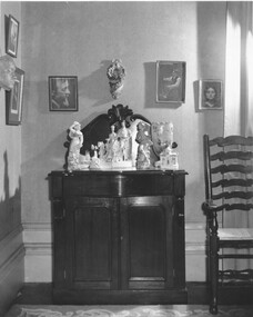
Photograph - Interior, D'Estaville, c.1965
The Melbourne artist Alma Agnes Marion Figuerola, was the daughter of Juan Pedro Narciso Figuerola (1869-1919) and Alice Lucinda Walker Hanson (1889-1969). Each of their three daughters grew up to be involved in the arts: Alma as a painter; Carmen Irene (1906-1993) as a short story writer, poet and teacher of dancing; and Sylvia (also Silvia) Lyla Alice (1911-1992) as a composer and cellist. The first art lessons Alma Figuerola received were with Oscar Binder. Later she attended the art school established by the Melbourne 'tonalist' [Duncan] Max Meldrum (1875-1955). She graduated from his school in 1920, participating in her first group exhibition in the same year. Solo exhibitions of her work were to be held in 1933 at the Meldrum Gallery in Elizabeth Street, in 1937 and 1945 at the Athenaeum Gallery at 188 Collins Street, and in 1951 at Georges Gallery in Collins Street. Throughout her extensive career she participated in group exhibitions, usually with artists of the Meldrum School, and as a member of the Twenty Melbourne Painters, of which she was invited to become an associate in 1935. In 1953, her portrait of Professor ES Hills was entered in the Archibald Prize Competition of the Art Gallery of New South Wales. A resident of Kew from the 1930s - 51 Studley Park Road, often with her mother, her sister Carmen, or both - from c.1942 until her death she lived at 'D’Estaville', 7 Barry Street. From the late 1930s she is recorded as actively contributing to the arts at a local level. In 1939 and 1940 she participated in art exhibitions at the Hawthorn Municipal Library organised by Jessie Carbines. From 1944 to 1951 she co-organised successive Kew Arts Festivals, initially in the Presbyterian Church Hall in Highbury Grove and later at the Recreation Hall in Wellington Street. A foundation member of the Kew Historical Society in 1958, Alma Figuerola remained an active member of the Society until her death on 8 December 1970. She predeceased her two sisters who both died in the 1990s and who are buried at Andersons' Creek Cemetery in Warrandyte.Part of a photographic series which is historically and aesthetically significant. The photographs record the interiors and exteriors of D'Estaville, an historic Kew mansion in the 1960s, and also its owner, Alma Figuerola, a pupil of Max Meldrum, and a notable Melbourne artist who lived in Kew.Interior, D'Estaville. A chiffonaire owned by the artist Alma Figuerola and located in her house, D'Estaville in Barry Street, Kew. This is a newspaper photograph, part of a series by The Age on the artist Alma Figuerola, and is still under copyright. Alma Figuerola was a foundation member of the Kew Historical Society. She died in 1970, so the photograph predates this.australian artists, d'estaville -- 7 barry street -- kew (vic), alma figuerola -
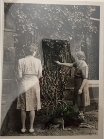 Kew Historical Society Inc
Photograph - The Figuerola Sisters in the Garden of D'Estaville, The Age, c.1965
The Melbourne artist Alma Agnes Marion Figuerola, was the daughter of Juan Pedro Narciso Figuerola (1869-1919) and Alice Lucinda Walker Hanson (1889-1969). Each of their three daughters grew up to be involved in the arts: Alma as a painter; Carmen Irene (1906-1993) as a short story writer, poet and teacher of dancing; and Sylvia (also Silvia) Lyla Alice (1911-1992) as a composer and cellist. The first art lessons Alma Figuerola received were with Oscar Binder. Later she attended the art school established by the Melbourne 'tonalist' [Duncan] Max Meldrum (1875-1955). She graduated from his school in 1920, participating in her first group exhibition in the same year. Solo exhibitions of her work were to be held in 1933 at the Meldrum Gallery in Elizabeth Street, in 1937 and 1945 at the Athenaeum Gallery at 188 Collins Street, and in 1951 at Georges Gallery in Collins Street. Throughout her extensive career she participated in group exhibitions, usually with artists of the Meldrum School, and as a member of the Twenty Melbourne Painters, of which she was invited to become an associate in 1935. In 1953, her portrait of Professor ES Hills was entered in the Archibald Prize Competition of the Art Gallery of New South Wales. A resident of Kew from the 1930s - 51 Studley Park Road, often with her mother, her sister Carmen, or both - from c.1942 until her death she lived at 'D’Estaville', 7 Barry Street. From the late 1930s she is recorded as actively contributing to the arts at a local level. In 1939 and 1940 she participated in art exhibitions at the Hawthorn Municipal Library organised by Jessie Carbines. From 1944 to 1951 she co-organised successive Kew Arts Festivals, initially in the Presbyterian Church Hall in Highbury Grove and later at the Recreation Hall in Wellington Street. A foundation member of the Kew Historical Society in 1958, Alma Figuerola remained an active member of the Society until her death on 8 December 1970. She predeceased her two sisters who both died in the 1990s and who are buried at Andersons' Creek Cemetery in Warrandyte.Part of a photographic series which is historically and aesthetically significant. The photographs record the interiors and exteriors of D'Estaville, an historic Kew mansion in the 1960s, and also its owner, Alma Figuerola, a pupil of Max Meldrum, and a notable Melbourne artist who lived in Kew.Alma Figuerola and her sister standing beside a creeper growing up the wall of D'Estaville, Barry Street, Kew. This is a newspaper photograph, part of a series by The Age on the artist Alma Figuerola, and is still under copyright. Alma Figuerola was a foundation member of the Kew Historical Society. She died in 1970, so the photograph predates this.australian artists, d'estaville -- 7 barry street -- kew (vic), alma figuerola -- melbourne artists -
 Kew Historical Society Inc
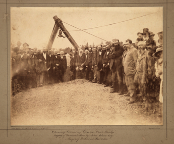
Photograph, Opening Ceremony Victoria Street Bridge: Laying of memorial stone by John Adam Esq. Mayor of Richmond, 1884
A formal group photograph of the grand opening of the Victoria Street Bridge on March 31 1884. The Argus was to report that: ‘The ceremony of laying the memorial stone of the Victoria-bridge, which connects Kew and Hawthorn with Richmond and Collingwood, was performed yesterday afternoon by the mayor of Richmond (Mr John Adam) in the presence of a large assemblage. Among the gentlemen present at yesterday’s proceedings were the mayor of Collingwood (Mr. M. Dwyer), the Mayor of Melbourne (Councillor C. Smith, M.L. A.) the mayor of Kew (Mr. Barnard), Mr. J. A. B. Koch and Mr. W. W. Shelley (ex mayors of Richmond), Mr. Joseph Bosisto, M.L.A., the Hon. L. L. Smith, Councillor De Mole (ex mayor of Kew), Mr. Jas. Lancashire and Mr. Winter (ex mayors of Ricmond), Mr. Walker (ex mayors of Collingwood), Mr. Johnson (engineer), Mr. C. Rowan, C.E. (engineer of the bridge alterations) and the town clerks of Richmond, Collingwood and Kew.’ Following the opening ceremony ‘… a ponderous steam roller was driven over the structure, with a view to test, or rather to demonstrate its stability … Most of the gentlemen present walked over the bridge, after which they were grouped by a photographer, with the memorial stone as a central feature, and several views of the scene were taken’.An original, rare silver albumen mounted and titled photograph of an important event in 19th century Melbourne.Original photograph mounted on display card of the opening of the Victoria Street Bridge. The original photograph is very faded and has been enhanced to improve the image's viewability.On the reverse of the card is an indecipherable stamp and an inscription identifying the photographers. "T. W. & C. A. McAlpine Bros, Photographers &., Campbell Parade East Richmond Melbourne March 31.1884victoria street bridge, john adam, m. dwyer, c. smith, barnard, j.a.b. koch, w.w. shelley, bridge, kew, collingwood, l.l. smith, joseph bosisto -
 Kiewa Valley Historical Society
Photographs – Set of 13 colour photographs of spectators preparing for the street parade to celebrate the first Official Hoppet race run at Falls Creek in 1991, 1991
In 1977 a group of Mount Beauty cross country skiers formed the Birkebeiner Nordic Ski Club. In 1979, a version of the famous Birkebeiner race, the first Australian Birkebeiner was held at Falls Creek. In June 1990 representatives from Australia put their case for a southern hemisphere race in the series. Following a trial event in 1990. Australia became the 12th member of Worldloppet in the winter of 1991, with the first Kangaroo Hoppet. In 1991 a parade and commemorative torch lighting ceremony were organised in Mt Beauty as part of the celebrations to mark the first official Kangaroo Hoppett with participation from local community groups and commercial organisations, the Chamber of Commerce, local government representatives and individuals.Kangaroo Hoppet caters to diverse interests by offering a 42km and 21km event. It also offers a 7km event that attracts skiers, ranging from elite juniors to parents, grandparents, babies and first time skiers. It is recognised on the world cross country ski race calendar. It brings large numbers of participants and spectators to the area which support tourism, local businesses and employment. The 2018 event will be the 28th Kangaroo Hoppet, with cross country skiers travelling from across the country and overseas to compete.Set of 13 colour photographs of spectators lining both sides of Holland St in preparation for the Kangaroo Hoppet street parade. Photographs show the original hospital buildings and street-scape of the early 1990’sNo markingskangaroo hoppet; cross country skiing; ski race; bogong high plains, mt beauty, parade -
 Glenelg Shire Council Cultural Collection
Photograph - Photograph reprint of scan of photograph - Flood August 1909, Casterton, Victoria, n.d
Vern McCallum CollectionReprint of scan of black and white photograph. Image show's Henty Street Casterton, flooded. Group of men on right standing in streets in ankle deep water. Print mounted on white archival mountboard frame. -
4th/19th Prince of Wales's Light Horse Regiment Unit History Room
Photograph, est late 1800's
A photo of a large contingent of mounted soldiers parading through the streets of a city. The uniforms indicate the South African War era. It could be a farewell parade, with many citizens on each side of the street. There is indication of location.Nilphoto, colonial era, photo, colonial era -
 Eltham District Historical Society Inc
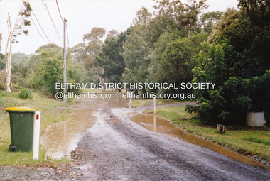
Photograph, Flooding of Diamond Creek, Eltham, Feb 2005, 2005
Two colour photographs of the Diamond Creek floodwater; two at Souter Street and one looking north across the Eltham Rugby Union Football Club oval towards the Bridge Street bridge, Feb 2005eltham, diamond creek, floods, souter street, bridge street -
 Federation University Historical Collection
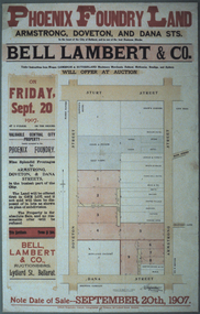
Photograph - Colour, Photograph of the Phoenix Foundry Land Sale Poster, 1907
Photograph of a poster advertising the auction of Phoenix Foundry Land located on the corner of Armstrong, Doveton and Dana Streets in Ballarat held on 20 September 1907 by Bell, Lambert and Co., auctioneers of Lydiard Street, Ballarat.phoenix foundry, ballarat, newton's hotel, coles and pullum, sale yards, snow's corner, bazaar hotel, stork hotel, jordon and tippett, reid's stables, town hall hotel, mead and co, smith, mather, gazzard, coffee palace, whykes, dimond building, rowland's factory, hunter, hunter daniel & co, ballarat brewing company, tulloch, armstrong street south, doveton street south, dana street -
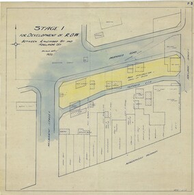 Ringwood and District Historical Society
Map, Development of Right of Way Stage 1, Ringwood, Victoria - 1950
Borough Engineer's technical drawing for Development of Right of Way between Ringwood Street and Adelaide Street, Ringwood, showing existing recreation reserve, retail establishments, outbuildings, and area available for lock-up shops.Scale 20' = 1". ACR 10.7.50. (Alan Charles Robertson - Borough Engineer) -
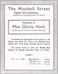 Bendigo Historical Society Inc.
Document - BENDIGO EASTER FAIR COLLECTION: POPULAR GIRL COMMITTEE MITCHELL STREET, 9th April, 1955
Copy of document - The Mitchell Street, popular Girl Committee, sub-section of the Bendigo Easter Fair Society, presented to Miss Gloria Hunt, the winning girl of the four streets competition, 9 April, 1955.person, certificate, popular girl gloria hunt -
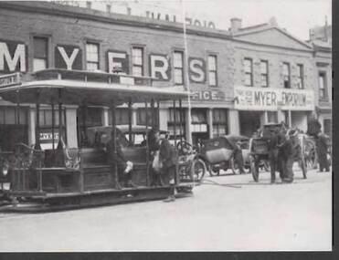 Bendigo Historical Society Inc.
Postcard - POSTCARD: LONSDALE STREET MELBOURNE MYER WAREHOUSES C 1920
2 x copies of Postcards showing Myers Lonsdale Street Store Melbourne, Myer Warehouse c 1920 - note on the back showing ' Lonsdale Street Warehouses, later to become the 11 storey store.'postcard, photograph, lonsdale street melbourne -myer warehouses c 1920 -
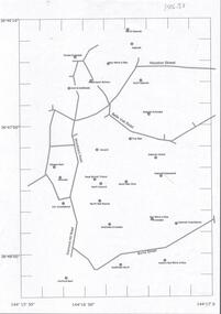 Bendigo Historical Society Inc.
Document - CENTRAL DEBORAH GOLD MINE : GOLDEN SQUARE MINE SITES
Map showing mines in the Golden Square, Diamond Hill area. Roads include Diamond Hill Road, Burns Street, Woodward Road, Belle Vue Road, Houston Street. Latitude and Longitude on map.bendigo, mining, golden square mine sites -
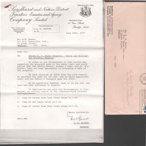 Bendigo Historical Society Inc.
Document - W.D.MASON COLLECTION: LETTER, 29 July 1975
Document, W.D.Mason Collection, a letter from Sandhurst and Northern District Trustees Executors Agency Company Limited, 18 View Street, Bendigo, Re; Real Estate property--Myers and Williamson Streets, Bendigo.G,D,McLeodbusiness, retail, w d mason -
 Port Melbourne Historical & Preservation Society
Photograph - Cruikshank Street, Port Melbourne, Jim Peterson, 1930
Original presented to Council in 1980s by the Cricketers ArmsCopy from photo hanging on Town Hall wall of Cruikshank Street 1930 (sepia print): 'Presented to the Cricketers Arms Hotel by Jack Cooper - Cruickshank (sic) Street Port Melbourne - Feb. 1930'hotels, built environment, cricketers arms hotel, jim peterson -
Port Melbourne Historical & Preservation Society
Photograph - Ken Turner with his mother, Lily Norton Turner, in back garden, 190 Nott Street, Port Melbourne, 1940s
B&W lasercopy, one of five on a page of photos of Bert Turner family of Nott Street: young Ken Turner and mother Lily Norton Turner in back garden of 190 Nott Street 1940s?domestic life, built environment - domestic, bert turner, lily norton turner -
 Port Melbourne Historical & Preservation Society
Photograph - Railway sidings on Evans Street, Port Melbourne, Glen Stuart, 1987
From set of nine colour photographs of various locations on the Port Melbourne Railway Line from Port Melbourne to Montague Stations, 1987: Railway sidings on Evans Street, taken from Bridge Streettransport - railways, glen stuart -
 Port Melbourne Historical & Preservation Society
Photograph - Construction of rock wall at George Samuel Walter Memorial Garden, Jack GOULD, C. 1950-55
From a box of photographs in Nancy U'REN's papers used during research for her thesis, The Early Growth and Development of Sandridge (1976) and/or her book with Noel TURNBULL, A History of Port Melbourne (1983). Black and white photograph showing Crockford Street as it turns into Bay Street. A worker is bent over on the edge of George Samuel Walter Memorial Garden next to a pile of rocks beginning the construction of the rock wall.bay street, crockford street, port melbourne town hall, george samuel walter memorial garden, nancy u'ren nee morris -
 Tatura Irrigation & Wartime Camps Museum
Photograph, Commercial Bank of Australia
Features R-L: Commercial Bank of Australia, C. Mitchell Newsagency, Charles Brady Draper. East end of Hogan Street. Features a girl child crossing the street; womand and child at newsagent's shopfront.tatura, buildings, historic, costume, children, female