Showing 174280 items matching "1200-mair-street"
-
 Greensborough Historical Society
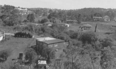
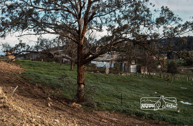
Photograph - Digital image, View of Bicton Street from Gladstone Road, 1950_
This view of Bicton Street Greensborough, taken from Gladstone Road Briar Hill circa 1950 shows the rural nature of the suburb at this time.Digital copy of black and white photo.bicton street greensborough, gladstone road briar hill -
 Greensborough Historical Society
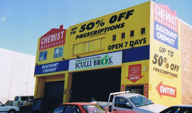
Photograph - Digital image, Frank Solomon, Rear of Chemist Warehouse, Main Street Greensborough, 04/06/2010
Rear of Chemist Warehouse, Main Street Greensborough, still showing the Sculli's sign. Sculli's now operate from a store in Greensborough Plaza.Digital copy of colour photographmain street greensborough, sculli family, chemist warehouse greensborough -
 Eltham District Historical Society Inc
Photograph, Looking north along Main Road from Cecil Street intersection, Eltham, February 1968, Feb 1968
Shows position of under road water course, which also went under railway line to the Diamond Creek and Cecil Street sign.In February 1968 an unknown person took a series of photos from the Eltham Hotel at Pitt Street heading north along Main Road through the shopping centre to just north of Elsa Court covering the length of the section of Main Road which was duplicated shortly thereafter. Shows the condition and environment of the streesscape of Main Road, Eltham immediately prior to the duplication between Pitt Street and Elsa Court through the shopping centre. Also shows a number of shops and businesses that operated at that time.Black and white photographduplication, eltham, main road, cecil street, railway line, watercourse, floods -
 Eltham District Historical Society Inc
Photograph, George W. Bell, Mobil Service Station, cnr Main Road and Brougham Street, Eltham
Sunset past service station cnr. Main Road and Brougham Street Eltham, opposite Court House. The service station was demolished 1999Black and white printeltham, main road, service stations, brougham street, george w bell collection, mobil service station -
 Eltham District Historical Society Inc
Photograph, Fred Mitchell, Site of the new Eltham Town Park, corner of Main Road and Bridge Street, Eltham, 1968, 1968
During the Main Road duplication. Bridge Street in background to the right of picture. Eltham Town Park was later renamed Alistair Knox Park.Digital copy of colour photographfred mitchell collection, 1968, main road, road construction, duplication, alistair knox park, bridge street, eltham town park -
 Stawell Historical Society Inc
Photograph, Lodestone Service Station Cnr Seaby & Longfield Streets Stawell with the Stone Cob & Co Stables in Seaby Street clearly seen in background of photo
Lodestone Service Station Cnr Seaby & Longfield Sts. Stone Cob & Co Stables in Seaby Street clearly seen in background of photo.stawell -
 Stawell Historical Society Inc
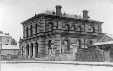
Photograph, New Court House in Patrick Street
Court House Patrick Street showing weatherboard house at right of photo and weatherboard shop at left of photo. And part of Royal Exchange Hotel.B/W Photograph of the Stawell Courthouse. A Substancial two story brick building. the building has three arches at the enterence, with a wrouht iron fence either side of the arches.It also has arched windows, and a slate roof.stawell building, court house -
 Stawell Historical Society Inc
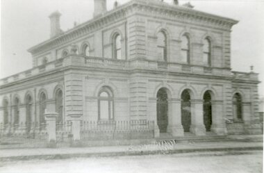
Photograph, Court House in Patrick Street
Court House Patrick Street showing weatherboard house at right of photo and weatherboard shop at left of photo. And part of Royal Exchange Hotel.B/W Photograph of the Stawell Courthouse. A Substancial two story brick building. the building has three arches at the enterence, with a wrouht iron fence either side of the arches.It also has arched windows, and a slate roof.stawell building, court house -
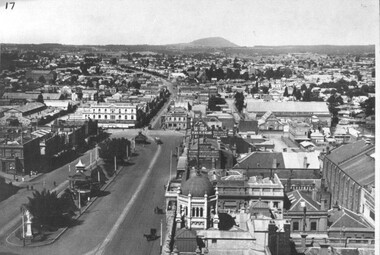 City of Ballarat Libraries
Photograph, Photo taken from the Town Hall Tower along Sturt Street facing east
Photo taken from the Town Hall Tower showing lower Sturt Street looking east. The Camp Hill Gardens can be seen.town hall, ballarat, sturt street, ballarat east -
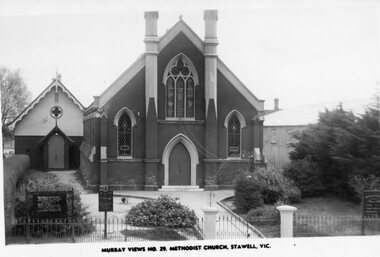 Stawell Historical Society Inc
Photograph, Stawell Methodist Church in Main Street Stawell -- Postcard
Stawell Methodist Church. Main Street Stawell. Original Post Card. Murray Views No. 29. Sunday School behind Church on left.stawell -
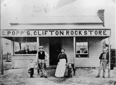 Stawell Historical Society Inc
Photograph, Mr C. Popp’s Clifton Rock Store on the the corner of Newington Road and Sophia Street Stawell
C. Popp’s Clifton Rock Store simple wooden cottage with verandah across front. Located at corner of Newington Road and Sophia Street.stawell -
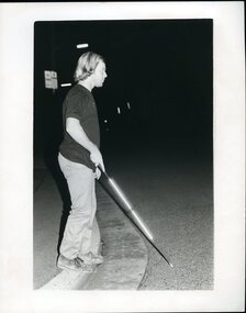 Vision Australia
Photograph - Image, Man crossing street using white cane at night
A man uses a white cane crossing a street at night in Newcastle. His cane reflects the photographer's flash and is illuminated against the dark night.Black and white photograph of a man using a white cane at nightOrientation and mobility at night - Newcastle Please return to RBSwhite cane day, royal blind society of new south wales -
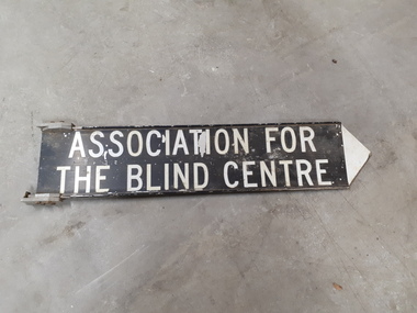 Vision Australia
Sign - Image, Street sign for the Association for the Blind
A metal street sign with a black background and white writing and a white pointing tip at the end, indicating which direction the Association for the Blind was located.Black and white road signAssociation for the Blind Centreassociation for the blind, nameplates -
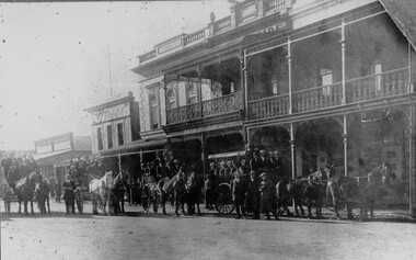 Stawell Historical Society Inc
Photograph, Fully Loaded horse drawn carriages in Main Street Stawell
Main Street Scene Bone Saddlers and Harness Maker Times Newspaper Office. Whiteside's building at centre and Town Hall Hotel on Rightstawell -
 Stawell Historical Society Inc
Archive - Blueprint, Methodist Church Main Street Plans, 20/10/1965
Alterations and additions to Stawell Methodist Church Main Street Earle and Associates Architects 25/10/1965 Job 6455 Drawing 3Paper in brown Cardboard roll holderreligion -
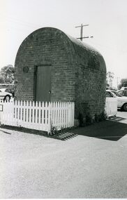 Stawell Historical Society Inc
Photograph, Powder Magazine in Church Street Stawell c1990
B/W Photo of Powder Magazine Church Street Stawell. Built at rear of shop belonging to Wright Pawsey Mitchell Hardware. C1990stawell mining -
 Port Melbourne Historical & Preservation Society
Photograph - Station Hotel, corner Bridge and Station Streets, Port Melbourne, c. 1950
Black & white photograph of the Station Hotel with Railway reserve & Bridge Street in the foreground.On reverse ' Station Hotel Cnr Bridge & Station Streets'business and traders - hotels, built environment - commercial, built environment - domestic, station hotel -
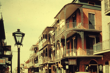 Robin Boyd Foundation
Slide, Commercial, 1956-1957
Robin Boyd developed a close friendship with the founder of the Bauhaus in Weimar Germany, Walter Gropius, who had moved to the USA in the 1930s. Through this connection, Boyd was invited to be the Massachusetts Institute of Technology (MIT) Bemis Professor at the School in the North American academic year 1956-7. Robin and Patricia Boyd, with their youngest daughter Suzy, were based in Cambridge, Massachusetts for the year. Boyd gave some lectures at MIT and he was also invited to give lectures at many other universities, allowing him to travel widely within the USA, especially on the East Coast. This gave him the opportunity to meet architects like Frank Lloyd Wright, Eero Saarinen, Paul Rudolph and many others, and visit the offices of Skidmore, Owings and Merrill, and places like Taliesin and the General Motors Technical Center Detroit. On the way home, the Boyds visited London, Berlin, Paris and Le Corbusier’s Ronchamp Chapel in France.Colour slide in a mount. St Peter Street, New Orleans, Louisiana, USASt. Peter Street / RB / C (All Handwritten)mit bemis professorship, mit, robin boyd, slide -
 Stawell Historical Society Inc
Photograph, Stawell Technical School in Skene Street Stawell
Stawell Technical School, Skene Street Stawell. The school had its first origins in an inquiry in c 1882 by the inspector of Schools of Design. A meeting was called Sept.1882, the first outcome of this meeting, was to advertised for, Friday 12th October 1882 from 7.30 pm to 9.30 pm in the Mechanic's Institute. The School of Mines was opened in the old market building. A complete new building in Patrick Street "Gold Reef Campus".Black & white photograph of a brick building with two pairs of windows on either side of the main entrance, with a parapet. Stawell Technical Schoolstawell building education -
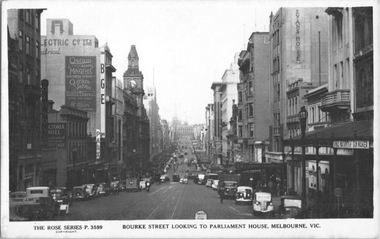 Melbourne Tram Museum
Postcard, Rose Stereograph Co, "Bourke Street looking to Parliament House, Melbourne", c1939
Rose Series postcard No. P 3589, titled "Bourke Street looking to Parliament House, Melbourne". The photo looks east from Queen Street. There are several cable trams in the view. Has signs for Gibson, the Victoria Hotel, Osram lamps and valves, BGE, Myer, Foys, Danks, Thomas Evans, Donald Macintosh gun maker, and the Evans House, The Commercial Bank of Australia. See item 8071 for a similar image.Yields information about Bourke St c1939.Postcard - printed real photograph with Rose Stereograph Co. name on the rear.trams, tramways, cable trams, bourke st -
Glenelg Shire Council Cultural Collection
Photograph - Photograph - Julia St Portland, Victoria, n.d
Black and white photo. Julia St. Portland, between Percy and Bentinck Streets, looking westBack: 'Julia Street, Portland' - black print -
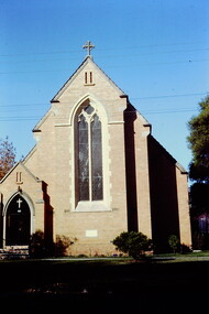 Kew Historical Society Inc
Slide - St Hilary's Anglican Church, Kew, 1979
One of a group of slides taken by members of the Society of built heritage in Kew in 1979-80. The selection of subject matter reflects the priorities of the period. The colour of some slides has degraded.The slides represent a snapshot in time of built architecture in Kew, much of which has changed in the forty-plus period since they were created.Colour positive transparency (slide) of St Hilary's Anglican Church in John Street Kew, 1979."St Hilary's Church of Engand John Street"historic houses -- kew (vic.), churches -- kew (vic.), anglican churches -- kew (vic.), st hilary's church -- kew (vic.) -
 Eltham District Historical Society Inc
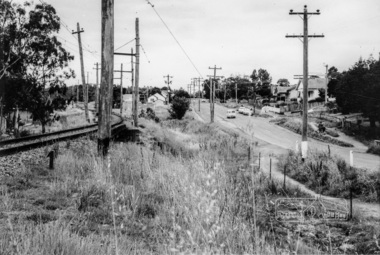
Album - Photograph, J.A. McDonald, General; Albion Street and Eltham-Yarra Glen Road, Oct. 1955
General – Country Roads Board Albion Street bridge over Moonee Ponds Creek, Brunswick West Derrick for launching beams October 1955Record of various Shire of Eltham infrastructure works undertaken during the period of 1952-1962 involving bridge and road reconstruction projects, sometimes with Eltham Shire Council Project Reference numbers quoted. It was during this period that a number of significant improvements were made to roads and new bridges constructed within the shire that remain in place as of present day (2022). In many situations, the photos provide a tangible visible record of infrastructure that existed throughout the early days of the Shire. The album was put together by or under the direction of the Shire Engineer, J.A. McDonald.infrastructure, road construction, shire of eltham, 1955-10, albion street, bridge construction, country roads board, benchmark studies, brunswick west, moonee ponds creek -
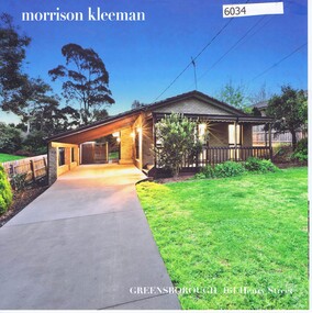 Greensborough Historical Society
Advertising Leaflet, 161 Henry Street Greensborough, 17/11/2017
161 Henry Street Greensborough. 3 bedroom house October 2017 for $740,000. Previous sales: May 2012 for $450,000 and November 2005 for $268,000.Real Estate advertising leaflet,1 sheet folded into 4 pages, printed in colour both sides.henry street greensborough -
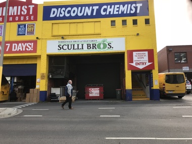 Greensborough Historical Society
Photograph - Digital Image, Sue Ballantyne, Sculli sign, rear Main Street 2018, 31/07/2018
This photograph shows the Sculli Bros sign at the rear of Chemist Warehouse in Main Street Greensborough. This building was formerly Sculli Bros fruit and vegetable shop.Digital copy of colour photographmain street greensborough, sculli family, sculli -
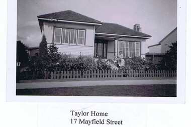 Greensborough Historical Society
Photograph - Digital image, Taylor home 17 Mayfield Street Greensborough, 1950s
Part of a group of photographs copied from the collection of Dot Jewell of Montmorency. This photograph is labeled and shows the Taylor home at 17 Mayfield Street Greensborough.Digital copy of colour photograph. Photograph is labelled.dot jewell, taylor family, mayfield street -
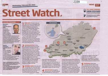 Greensborough Historical Society
Newspaper clipping, Diamond Valley Leader, Street Watch. Diamond Valley Leader. From 2015, 18/02/2015
Street Watch is published weekly in the Diamond Valley Leader and contains police reports including local crimes and missing persons. There is an incomplete run of this column.Half page newspaper clipping with map and text.street watch, diamond valley leader -
 Greensborough Historical Society
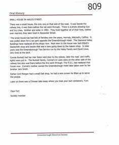
Article, Small house in Hailes Street by Faye Fort, 1902o
Faye Fort relates some of the families who lived in this house in Hailes Street Greensborough and describes its demise to make way for a carpark and shops.An oral history of one house in Greensborough.One types page of text.hailes street greensborough, faye fort -
 Eltham District Historical Society Inc
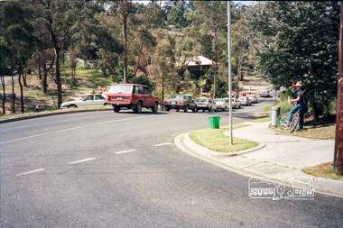
Photograph, School pick-up traffic from Eltham East Primary School, Beard Street, c.April 1987
Probably a Shire of Eltham investigation into traffic and parking at school pick-up times At the junction of Grove and Beard Streets viewed from Wycliffe CrescentRoll of 35mm colour negative film, 3 stripsKodak GA 100 5095shire of eltham, eltham east primary school, roads, grove street, beard street, wycliffe crescent -
 Eltham District Historical Society Inc
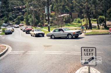
Photograph, School pick-up traffic from Eltham East Primary School, Beard Street, c.April 1987
Probably a Shire of Eltham investigation into traffic and parking at school pick-up times At the junction of Grove and Beard Streets viewed from Wycliffe CrescentRoll of 35mm colour negative film, 3 stripsKodak GA 100 5095shire of eltham, eltham east primary school, roads, grove street, beard street, wycliffe crescent