Showing 11019 items
matching various.
-
 Eltham District Historical Society Inc
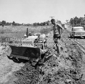
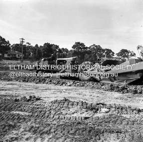
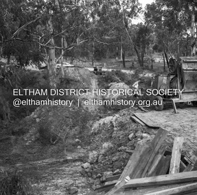
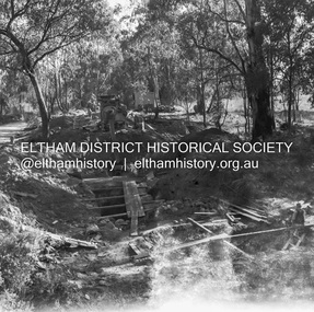
Negative - Photograph, J.A. McDonald, Eltham, Susan Street, Jan. 1961
January 1961 Looking south Brown excavating Brougham to Dalton (present-day Withers Way) F. Woods Consolidating showing soft fill over culvert after 9 months Just south of Brougham Street. To the immediate left is the present-day car park for the Elham Leisure Centre. The house on the left is immediately opposite Cromwell street and adjacent to the southwest corner of the Leisure Centre buiding (where the Williams house sits hidden from view)Record of various Shire of Eltham infrastructure works undertaken during the period of 1952-1962 involving bridge and road reconstruction projects, sometimes with Eltham Shire Council Project Reference numbers quoted. It was during this period that a number of significant improvements were made to roads and new bridges constructed within the shire that remain in place as of present day (2022). In many situations, the photos provide a tangible visible record of infrastructure that existed throughout the early days of the Shire. The album was put together by or under the direction of the Shire Engineer, J.A. McDonald.shire of eltham, infrastructure, 1961-01, cromwell street, eltham leisure centre, road construction, susan street -
 Eltham District Historical Society Inc
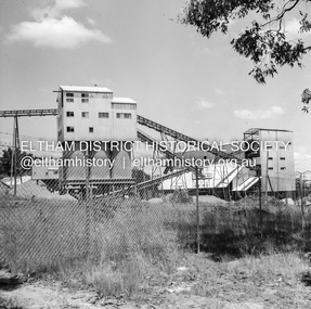
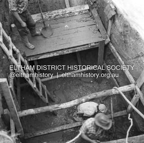
Negative - Photograph, J.A. McDonald, Unidentified quarry, Jan. 1961
Record of various Shire of Eltham infrastructure works undertaken during the period of 1952-1962 involving bridge and road reconstruction projects, sometimes with Eltham Shire Council Project Reference numbers quoted. It was during this period that a number of significant improvements were made to roads and new bridges constructed within the shire that remain in place as of present day (2022). In many situations, the photos provide a tangible visible record of infrastructure that existed throughout the early days of the Shire. The album was put together by or under the direction of the Shire Engineer, J.A. McDonald.1961-01, quarry -
 Eltham District Historical Society Inc
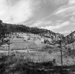
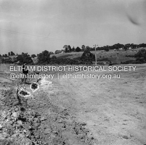
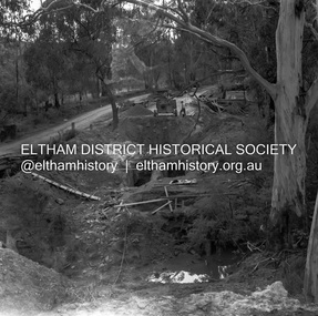
Negative - Photograph, J.A. McDonald, Reconstruction works, Lower Plenty Oval, Jan. 1961
3 February 1961 Looking towards Rattray RoadRecord of various Shire of Eltham infrastructure works undertaken during the period of 1952-1962 involving bridge and road reconstruction projects, sometimes with Eltham Shire Council Project Reference numbers quoted. It was during this period that a number of significant improvements were made to roads and new bridges constructed within the shire that remain in place as of present day (2022). In many situations, the photos provide a tangible visible record of infrastructure that existed throughout the early days of the Shire. The album was put together by or under the direction of the Shire Engineer, J.A. McDonald.1961-01, infrastructure, lower plenty oval, reconstruction works, shire of eltham -
 Eltham District Historical Society Inc
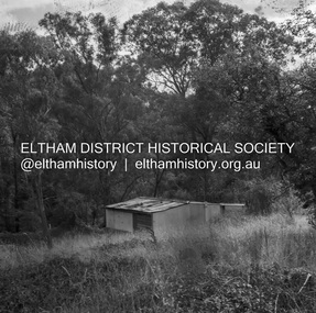
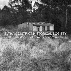
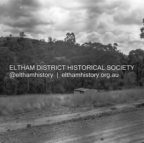
Negative - Photograph, J.A. McDonald, Road Reserve Housing, Mar. 1961
Shack built on road reserve without permit Most probably up on Simms Road, Kinglake Other areas where illegal shacks were built wer at the junction of Flat Rock Road and Cherry Tree Road, Hurstbridge. At times, Building Surveyor George E Newton would have to attend to these shacks for inspection and issue demolition ordersRecord of various Shire of Eltham infrastructure works undertaken during the period of 1952-1962 involving bridge and road reconstruction projects, sometimes with Eltham Shire Council Project Reference numbers quoted. It was during this period that a number of significant improvements were made to roads and new bridges constructed within the shire that remain in place as of present day (2022). In many situations, the photos provide a tangible visible record of infrastructure that existed throughout the early days of the Shire. The album was put together by or under the direction of the Shire Engineer, J.A. McDonald.infrastructure, shire of eltham, 1961-03, building surveyor, cherry tree road, flat rock road, george e. newton, houses, hurstbridge, kinglake, road reserve, road reserve housing, scan - 120 format 6x6 negative, shack, simms road -
 Eltham District Historical Society Inc
Negative - Photograph, J.A. McDonald, Road Reserve Housing, Mar. 1961
Shack built on road reserve without permit Most probably up on Simms Road, Kinglake Other areas where illegal shacks were built were at the junction of Flat Rock Road and Cherry Tree Road, Hurstbridge. At times, Building Surveyor George E Newton would have to attend to these shacks for inspection and issue demolition ordersRecord of various Shire of Eltham infrastructure works undertaken during the period of 1952-1962 involving bridge and road reconstruction projects, sometimes with Eltham Shire Council Project Reference numbers quoted. It was during this period that a number of significant improvements were made to roads and new bridges constructed within the shire that remain in place as of present day (2022). In many situations, the photos provide a tangible visible record of infrastructure that existed throughout the early days of the Shire. The album was put together by or under the direction of the Shire Engineer, J.A. McDonald.infrastructure, shire of eltham, 1961-03, building surveyor, cherry tree road, flat rock road, george e. newton, houses, hurstbridge, kinglake, road reserve, road reserve housing, scan - 120 format 6x6 negative, shack, simms road -
 Eltham District Historical Society Inc
Negative - Photograph, J.A. McDonald, Henley Road at Watsons Creek, Mar. 1961
Old bridge over Watsons Creek 22 March 1961 Cr. Pelling and Contractor WolfRecord of various Shire of Eltham infrastructure works undertaken during the period of 1952-1962 involving bridge and road reconstruction projects, sometimes with Eltham Shire Council Project Reference numbers quoted. It was during this period that a number of significant improvements were made to roads and new bridges constructed within the shire that remain in place as of present day (2022). In many situations, the photos provide a tangible visible record of infrastructure that existed throughout the early days of the Shire. The album was put together by or under the direction of the Shire Engineer, J.A. McDonald.infrastructure, shire of eltham, 1961-03, bend of islands, cr. charis pelling, henley road, henley road bridge, kangaroo ground, oxley bridge, watsons creek, w.e. wolf, bridge construction, road construction -
 Eltham District Historical Society Inc
Negative - Photograph, J.A. McDonald, Henley Road at Watsons Creek, Mar. 1961
Henley Road at Watsons Creek Looking easterly along new alignment, 22 March 1961 C. Browns Excavator Contractor Wolf Cr PellingRecord of various Shire of Eltham infrastructure works undertaken during the period of 1952-1962 involving bridge and road reconstruction projects, sometimes with Eltham Shire Council Project Reference numbers quoted. It was during this period that a number of significant improvements were made to roads and new bridges constructed within the shire that remain in place as of present day (2022). In many situations, the photos provide a tangible visible record of infrastructure that existed throughout the early days of the Shire. The album was put together by or under the direction of the Shire Engineer, J.A. McDonald.infrastructure, shire of eltham, 1961-03, bend of islands, cr. charis pelling, henley road, henley road bridge, kangaroo ground, oxley bridge, watsons creek, w.e. wolf, bridge construction, road construction -
 Eltham District Historical Society Inc
Negative - Photograph, J.A. McDonald, Eltham, Haldane Road, Mar. 1961
Dr Donald Thomson's gate and entrance to his property 'Worlingworth' after flooding in March 1961 "Worlingworth", Eltham, was the home of noted anthropologist the late Professor Donald Thomson and his wife Dorita. The entrance gate on Banoon Road is located at the bottom of the hill opposite Haldane Road. The flooding issues were regularly reported to Council following heavy rain. Google Street View Feb 2014 https://goo.gl/maps/SGjsJAAEdjQXgo5V9Record of various Shire of Eltham infrastructure works undertaken during the period of 1952-1962 involving bridge and road reconstruction projects, sometimes with Eltham Shire Council Project Reference numbers quoted. It was during this period that a number of significant improvements were made to roads and new bridges constructed within the shire that remain in place as of present day (2022). In many situations, the photos provide a tangible visible record of infrastructure that existed throughout the early days of the Shire. The album was put together by or under the direction of the Shire Engineer, J.A. McDonald.infrastructure, shire of eltham, 1961-03, flood damage, haldane road, prof donald thomson, worlingworth -
 Eltham District Historical Society Inc
Negative - Photograph, J.A. McDonald, Para Road, Mar. 1961
Wash out 51 Para Road after heavy rain 28 March 1961Record of various Shire of Eltham infrastructure works undertaken during the period of 1952-1962 involving bridge and road reconstruction projects, sometimes with Eltham Shire Council Project Reference numbers quoted. It was during this period that a number of significant improvements were made to roads and new bridges constructed within the shire that remain in place as of present day (2022). In many situations, the photos provide a tangible visible record of infrastructure that existed throughout the early days of the Shire. The album was put together by or under the direction of the Shire Engineer, J.A. McDonald.infrastructure, shire of eltham, 1961-03, flood damage, para road -
 Eltham District Historical Society Inc
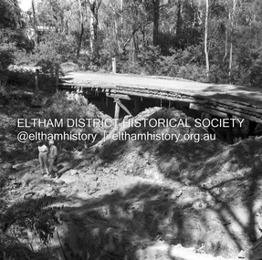
Negative - Photograph, J.A. McDonald, Henley Road at Watsons Creek, Apr. 1961
Henley Road at Watsons Creek looking easterly along centreline from west abutment Early April 1961Record of various Shire of Eltham infrastructure works undertaken during the period of 1952-1962 involving bridge and road reconstruction projects, sometimes with Eltham Shire Council Project Reference numbers quoted. It was during this period that a number of significant improvements were made to roads and new bridges constructed within the shire that remain in place as of present day (2022). In many situations, the photos provide a tangible visible record of infrastructure that existed throughout the early days of the Shire. The album was put together by or under the direction of the Shire Engineer, J.A. McDonald.infrastructure, shire of eltham, bend of islands, cr. charis pelling, henley road, henley road bridge, kangaroo ground, oxley bridge, watsons creek, w.e. wolf, bridge construction, road construction, 1961-04 -
 Eltham District Historical Society Inc
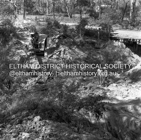
Negative - Photograph, J.A. McDonald, Henley Road at Watsons Creek, Apr. 1961
Henley Road at Watsons Creek showing excavation at western pier Rock at contract level, slight underground flow Early April 1961Record of various Shire of Eltham infrastructure works undertaken during the period of 1952-1962 involving bridge and road reconstruction projects, sometimes with Eltham Shire Council Project Reference numbers quoted. It was during this period that a number of significant improvements were made to roads and new bridges constructed within the shire that remain in place as of present day (2022). In many situations, the photos provide a tangible visible record of infrastructure that existed throughout the early days of the Shire. The album was put together by or under the direction of the Shire Engineer, J.A. McDonald.infrastructure, shire of eltham, bend of islands, cr. charis pelling, henley road, henley road bridge, kangaroo ground, oxley bridge, watsons creek, w.e. wolf, bridge construction, road construction, 1961-04 -
 Eltham District Historical Society Inc
Negative - Photograph, J.A. McDonald, Henley Road at Watsons Creek, Apr. 1961
Henley Road at Watsons Creek looking westerly along centreline from east abutment Early April 1961Record of various Shire of Eltham infrastructure works undertaken during the period of 1952-1962 involving bridge and road reconstruction projects, sometimes with Eltham Shire Council Project Reference numbers quoted. It was during this period that a number of significant improvements were made to roads and new bridges constructed within the shire that remain in place as of present day (2022). In many situations, the photos provide a tangible visible record of infrastructure that existed throughout the early days of the Shire. The album was put together by or under the direction of the Shire Engineer, J.A. McDonald.infrastructure, shire of eltham, bend of islands, cr. charis pelling, henley road, henley road bridge, kangaroo ground, oxley bridge, watsons creek, w.e. wolf, bridge construction, road construction, 1961-04 -
 Eltham District Historical Society Inc
Negative - Photograph, J.A. McDonald, Henley Road at Watsons Creek, Apr. 1961
Henley Road at Watsons Creek looking westerly showing west abutment excavation Mid April 1961Record of various Shire of Eltham infrastructure works undertaken during the period of 1952-1962 involving bridge and road reconstruction projects, sometimes with Eltham Shire Council Project Reference numbers quoted. It was during this period that a number of significant improvements were made to roads and new bridges constructed within the shire that remain in place as of present day (2022). In many situations, the photos provide a tangible visible record of infrastructure that existed throughout the early days of the Shire. The album was put together by or under the direction of the Shire Engineer, J.A. McDonald.infrastructure, shire of eltham, bend of islands, cr. charis pelling, henley road, henley road bridge, kangaroo ground, oxley bridge, watsons creek, w.e. wolf, bridge construction, road construction, 1961-04 -
 Eltham District Historical Society Inc
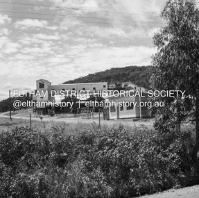
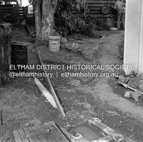
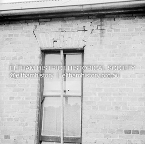
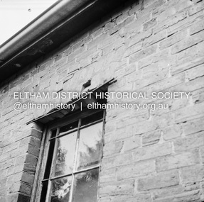
Negative - Photograph, J.A. McDonald, Old house, Susan Street, Eltham, c. 1962
Williams house, Susan StreetRecord of various Shire of Eltham infrastructure works undertaken during the period of 1952-1962 involving bridge and road reconstruction projects, sometimes with Eltham Shire Council Project Reference numbers quoted. It was during this period that a number of significant improvements were made to roads and new bridges constructed within the shire that remain in place as of present day (2022). In many situations, the photos provide a tangible visible record of infrastructure that existed throughout the early days of the Shire. The album was put together by or under the direction of the Shire Engineer, J.A. McDonald.eltham, houses, susan street, williams house -
 Eltham District Historical Society Inc
Negative - Photograph, J.A. McDonald, Old house, Susan Street, Eltham, c. 1962
Williams house, Susan StreetRecord of various Shire of Eltham infrastructure works undertaken during the period of 1952-1962 involving bridge and road reconstruction projects, sometimes with Eltham Shire Council Project Reference numbers quoted. It was during this period that a number of significant improvements were made to roads and new bridges constructed within the shire that remain in place as of present day (2022). In many situations, the photos provide a tangible visible record of infrastructure that existed throughout the early days of the Shire. The album was put together by or under the direction of the Shire Engineer, J.A. McDonald.eltham, houses, susan street, williams house -
 Bendigo Military Museum
Album - ALBUM, POSTCARD, WW1, 1914-1919
They are addressed from a George to his wife Louie. WW1. Item in the collection re George Bailey Jackson, refer cat No 3446P for his service details.This is a purchased buckram book. On front it shows gold line dropping down froma horizontal bar. The tips of the gold lines show a Fleur De Lys on each tip. The phrase "Postcard Album" is also printed in gold. Inside are numerous pages cut with various slots to hold postcards. The postcards are brilliant, beautiful and awe inspiring - their colours, cottons etc. Most are sewn, some are hand painted. Some have intricate lace work.A lot of postcards have "To Louie from George" (Louie possibly his wife), Louie was c/o address Nth Ryde, Isle of Wight, England. An early card is addressed to Miss Louie Hobbs, Southampton, England. A lot are about the Army Service Corps.postcards, ww1, passchendaele barracks trust -
 Frankston RSL Sub Branch
Collection, Badges
Framed and mounted collection of English World War 1 military metal unit insignia and unit names. There are a total of 70 various items (some duplication) mounted on a red velvet covered backing board of thick cardboard. Contained in a wooden cabinet complete with a hinged glass fronted door. The collection was the work of World War 1 English service man, ? Akeroyd, father of John Akeroyd, past President of Frankston RSL Sub Branch. -
 Flagstaff Hill Maritime Museum and Village
Textile - Bedspread, patchwork, 1976
This patchwork bedspread or quilt is a modern creation along the lines of the traditional 1800s handmade patchwork quilting craft. It is made from reproduction fabric and quilt designs and represents the bed linen typical of a late 19th-century bedroom. Years ago, patchwork was a form of recycling, where leftover or previously used pieces of fabric were used to create other useful item such as quilts, rugs, cushion covers and jackets. Special projects were sometimes made with fabrics representing special memories, such as pieces from baby clothes, wedding gowns, and school uniforms. The maker would use a cardboard template shaped like a hexagon, place it onto the fabric and trace around it. Often the cardboard was cut from a box such as a cereal box. Women would gather to work on their patchwork while enjoying their social time together. As in the case of this quilt, members of the Embroiderers Guild in Warrnambool worked on the project, designing and quilting as a group to achieve their aim, of presenting the quilt to the recently opened Flagstaff Hill Maritime Museum. The quilt was perfectly suited to dress the bed in the Lighthouse Keeper's Cottage. Provision was made for the quilt to be hung for display, with the addition of loops along one edge.This carefully created and designed, recently made patchwork bedspread typifies bedding and handcraft of the late 19th century. The bedspread was the first community project of the South Western Branch of the Embroiderers' Guild of Victoria, and presented as an addition to the Lighthouse Keeper's Cottage tat Flagstaff Hill. Patchwork bedspread or quilt, double bed size, made from hundreds of hexagonal-shaped fabric of various colours and patterns, carefully stitched onto a white background. One edge of the quilt has loops dispersed at regular intervals. This would allow the quit to be used as a wall hanging. It was handmade by the South Western Branch of The Embroiders Guild, Victoria, and presented to Flagstaff Hill Maritime Museum and Village in 1976. An inscription is embroidered in blue on a patch of the quilt. "Made and Presented by The Embroiderers Guild, Victoria (S.W. Branch) 1976"flagstaff hill, flagstaff hill maritime museum and village, warrnambool, maritime museum, maritime village, great ocean road, shipwreck coast, bedspread, patchwork quilt, quilt, embroiderers guild, bedding, bed linen, 1800's handcraft, quilting, south west branch, warrnambool embroiders guild, recycled fabric, 19th century, household textiles -
 Bendigo Historical Society Inc.
Document - BMTA COLLECTION: SCHOLARSHIP FOLDER, 2001 - 2006
BMTA Music Lover Club Scholarship 2005 sample documents Green Hard plastic cover Plastic Sleeves White paper A4 Handful A5 programmes for scholarship event Typed and hand written Nelle Thompson String Award History from minutes 2003-3006 Stuart Anderson Scholarship History from minutes 2001-2006 Various correnspondance and flyers regarding 2005 scholarship event Registration sample for 2003 Scholarship -
 Bendigo Historical Society Inc.
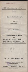
Document - H.A. & S.R. WILKINSON COLLECTION: CONDITION OF SALE
Conditions of sale by private contract dated 10th August, 1939 between Mrs L.T. McCullough (seller) and Mrs M. Rowe for the land situate Shamrock Street, Bendigo being part of Crown allotment 3, 6 and 7 section 33A land described in certificate of title volume 6198 folio 1239463. Price 190 pounds. Various receipt from Borough of Eaglehawk, Land department And water commission for rates, and other costs.organization, business, h.a. & s.r wilkinson real estate -
 Bendigo Historical Society Inc.
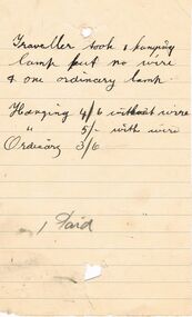
Document - PEARCE COLLECTION: VARIOUS HANDWRITTEN DOCUMENTS (ELDRIDGE & BURNET?)
Pearce Collection: Various handwritten documents (Eldridge & Burnet?) 1. page of items (first one is Gas Lamps; 2. page of accounts (Wages Paid/Rents/Carrier)3. Page of accounts by month for 1911 (amounts only); 4. Paper headed 490 Lons?? 5. Paper: Mr Gossman?? 5 Piece of paper - Mrs Manning? 6. Piece of paper - headed 'Traveller took …' 6. Page headed Wilson and ??business, retail, plumber -
 Bendigo Historical Society Inc.
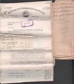
Document - COHN BROTHERS COLLECTION: SWAN HILL FACTORY DOCUMENTS
[a] Cohn Bros red printed 'Return to Sender' manilla envelope with captions' Swan Hill Branch, New factory buildings, Marsh & Michaelson, Mc' Dougall & Ireland, F K Powers to 22/9/ 1944, No 149. [b] Bundle of folded documents relating to Cohn Bros new factory building at Swan Hill, 1944. Marsh & Michaelson Architects, McDougal & Ireland Master Builders. Various costs related to build itemised.bendigo, industry, cohn bros brewery -
 Bendigo Historical Society Inc.
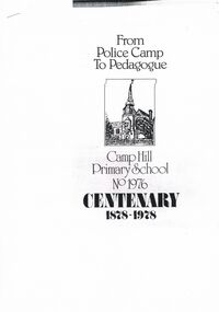
Document - FROM POLICE CAMP TO PEDAGOGUE: CAMP HILL PRIMARY SCHOOL CENTENARY PUBLICATION
''From Police Camp to Pedagogue'' - Camp Hill Primary School No. 1976 Centenary publication 1978. Compiled by Wesley C Harry and Edward C Thompson. Detailed 32 page photocopy history of school with some photos- various class photographs, views, ''Camp Hill Champion Club Swingers 1903''. Includes list of 1978 School Council (Arie Eyles - then current Principal; List of all Head Teachers for 1878 - 1977.Compiled by Wesley. C. Harry, Edward. C. Thompson.school, centenary, camp hill primary school no.1976 -
 Bendigo Historical Society Inc.
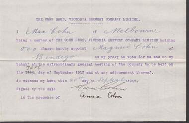
Document - COHN BROTHERS COLLECTION: 20TH CENTURY PROXYS
Sixteen 20th Century Cohns Proxys various names, dates and meetings usually appointing Magnus Cohn to act on their behalf. Names include Agnes Levy, Anna Cohn, Sophia Howell, Elizabeth Mary Watson, Sarah Helen Cohn, Max Cohn, Rosa Cohn, Dagmar Dyring, Mathilda and Bertha Cohn. Several Proxies contained in manilla envelope handwritten heading 'Meeting of 14/9/12 also 30/ 9/ 12.bendigo, industry, cohn bros brewery -
 Bendigo Historical Society Inc.
Document - MCCOLL, RANKIN AND STANISTREET COLLECTION: MINING COMPANIES FILE OF ADVERTISEMENTS, 1921 - 1940
Document: hard cover green book with buff spine. Contains numbered pages containing copies of newspaper advertisements by various mining companies and dates of publication. Pages 1 - 25 removed. Indexed A - Z in front. Loose at back - tender documents for sale of estate of John Roger Hurbury ( ? ) Bendigo. And tender document for sale of Clunes Knitting and Manufacturing Co. Ltd. On spine : 'Press ads' Attached is a synopsis of content prepared by Phyllis Toy.MCCOLL, RANKIN AND STANISTREETorganization, business, gold mining - advertisements, mccoll, rankin and stanistreet, gold mining