Showing 1938 items
matching flood
-
 Eltham District Historical Society Inc
Photograph, Diamond Creek floods 1953, 1953
Three photographs of Diamond Creek in flood 21/10/1953 showing concrete bridge, Eltham South, Diamond Street bridge and Glen Park bridgediamond creek, floods, eltham, bridges, main road, wattletree road, diamond street, glen park -
 Bendigo Historical Society Inc.
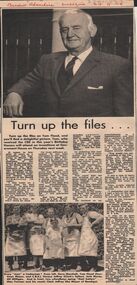
Newspaper - LYDIA CHANCELLOR: TOM FLOOD
A Bendigo 'Advertiser' article titled 'Turn up the files...' and is an account of the life of Tom Flood. It includes two black and white photographs. 24/9/1969.person, bendigo, tom flood, lydia chancellor collection, collection, flood's bus service, transport, bendigo, business, trades, history, male, individual, person, photo, photograph, photos, mayor, politics -
 Bendigo Historical Society Inc.
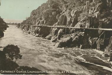
Postcard - GLADYS DEAN COLLECTION: POSTCARD, 1906 - 1908
Coloured photographic postcard depicting a fast-flowing river. The words "Cataract Gorge, Launceston, Tasmania, at flood time" are printed in white at the bottom. the postcard is unaddressed.postcard, tasmania, launceston, cataract gorge -
Bendigo Historical Society Inc.
Newspaper - WINIFRED JENNINGS COLLECTION: HEADLINE MOMENTS OF THE PAST
A collection of two news stories detailing the flooding of Bendigo CBD in 1949 and a story about living through the great depression as a teenager in 1931 by Mary Poulter.great depression, winifred jenning, flooding, cbd. -
University of Melbourne, Burnley Campus Archives
Newspaper - Newspaper Cutting, The Leader, Horticultural Notes, 1892
Copy of article in "The Leader" (Melbourne) 9 April 1892 p 10. Description of condition of Orchard after the earlier flood and finally water obtainable for irrigation.the leader, orchards, floods, irrigation, orchard -
 Lakes Entrance Historical Society
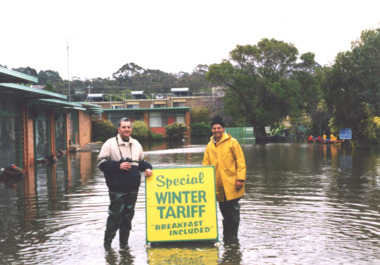
Photograph - floods 1998 Lakes Entrance Victoria, George Kyriakoo and Michael Pompaii at Sherwood Lodge Motel Lakes Entrance Victoria, 1/06/1998 12:00:00 AM
Colour photograph taken during floods showing George Kyriakoo and Michael Pompaii with water tariff sign at Sherwood Lodge Motel Lakes Entrance Victoriafloods, caravan parks -
Glenelg Shire Council Cultural Collection
Photograph - Photograph reprint of scan of photograph - Casterton 1906 (Taken after flood), Victoria, n.d
Vern McCallum CollectionReprint of scan of a black and white photograph. Image is of Casterton, after the 1906 flood, taken from an elevated position. Print mounted on the white, archival mountboard frame. -
Bendigo Historical Society Inc.
Photograph - TAMBOUR MAJOR MINE - PHOTO OF DIVER
Photocopy of a photo of a diver and nine men outside the mine. The diver was inspecting the flooded Tambour Major Mine at Specimen Hill in 1920. Photo taken by Percival ?, Bendigo.photo, group, male, tambour major mine, photo of diver -
 Kew Historical Society Inc
Photograph - Second Johnston Street Bridge in Flood, 1934
Original, small black and white print photograph of crowds lining the Johnston Street Bridge watching the flood waters below. The annotation on the reverse clarifies that Kew is in the distance.Annotated on reverse: "Gift of G.S. Beard / 2nd bridge / Johnston St. Studly Park Rd. Bridge looking towards Kew / 1st bridge 1858–1876, 2nd bridge built (bad bend), 1876–1958, 3rd bridge 1958, lined up Johnston St and Studley Park Rd."johnston street bridge, bridges - yarra river -- kew (vic.), flood -- 1934 -
Bendigo Symphony Orchestra Inc.
Work on paper - Sheet Music, Bartlett, Cally, Kati Thanda - Lake Eyre
Sheet Music for Kati Thanda - Lake Eyre by Cally BartlettParts printed on paper. Commissioned by the Bendigo Symphony Orchestra in 2020 this work for Symphony Orchestra tells the story of the flooding of Kati Thanda-Lake Eyre every decade.fictionSheet Music for Kati Thanda - Lake Eyre by Cally Bartlett -
 Lakes Entrance Historical Society
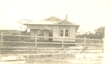
Photograph - Home of Fish Family, Roadknight Street Lakes Entrance Victoria, 1926 c
Also an enlarged copy of same photograph 05006.1 Built by J C Dahlsen for Vic Fish and family. Became shell museum 1960 to 70s for Mrs Newmans Camp Park named Gelia changed to Echo Beach, had various ownersBlack and white photograph of a small fibro clad house built for Vic and Myrtle Fish surrounded by receeding flood waters in Roadknight Street Lakes Entrance Victoriahouses, genealogy, floods -
Lakes Entrance Historical Society
Book, L V Printers, Red Alert, 2007
A pictorial record of the 2006/2007 Gippsland FiresRed covered paperback with 24 pagesnon-fictionA pictorial record of the 2006/2007 Gippsland Firesfires, disasters, fundraising -
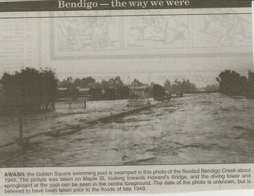 Bendigo Historical Society Inc.
Newspaper - JENNY FOLEY COLLECTION: AWASH
Bendigo Advertiser ''The way we were'' from 2000. Awash: the Golden Square swimming pool is swamped in this photo of the flooded Bendigo Creek about 1949. The picture was taken on Maple St. looking towards Howard's Bridge, and the diving tower and springboard at the pool can be seen in the centre foreground. The date of the photo is unknown, but is believed to have been taken prior to the floods of late 1949. The clip is in a folder.newspaper, bendigo advertiser, the way we were -
Whitehorse Historical Society Inc.
Correspondence, Documents re P.E. Eriksson property purchase, 1/03/1943
Invoice and receipt - property search for Mrs P.E. Eriksson from Flood & Permezel solicitors, Collins Street. Receipt for deposit from Frank Parker, Real Estate Agent. Title check and plan from Flood & Permezel. Copy, contract of sale - Insurance Policy Coop Insurance Co. Invoice Griffiths Bros, tea merchants Nov 1910 - Jan 1911 for Mrs A. Eriksson. Advice - certificate of title.eriksson, pearl eileen, w. h. flood & permezel, frank parker (real estate agent), warnes road, mitcham no 30, land sales, cooperative insurance company of australia, edgar -
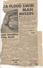 Ballarat Tramway Museum
Newspaper, Herald Sun, "Barwon fight", 19/06/1952 12:00:00 AM
Newspaper Clipping from the Melbourne "The Sun", dated 19/6/1952 about widespread flooding in Victoria and Wagga and on the right hand side of the clipping the Barwon River Geelong titled "Barwon fight". Notes the flooding over the Barwon River which caused suspension of the tram services. Contained originally within Reg Item 5623 at the front of this note book. For items see btm5623 loose items list.pdf.geelong, flooding -
Clunes Museum
Photograph
.1 17 PHOTOGRAPHS OF CENTENARY/BACK TO CLUNES 1939 .2 PHOTOGRAPH OF SCHOOL, BAILEY STREET .3 KODAK ENVELOPE FOR PHOTOGRAPHS .4 4 PHOTOGRAPHS OF CREEK IN FLOOD.3 WRITING ON COVER RED ON BLACK: HAPPY SNAPSback to clunes, centenary 1939 -
 Bendigo Historical Society Inc.
Newspaper - LYDIA CHANCELLOR COLLECTION: BENDIGO COMMUNITY
A decorated box containing cuttings from 'The Bendigo Advertiser' of life in Bendigo between 1961 and 1965. Includes weddings, floods, shire and council events, church activities etc.bendigo, history, community activities, lydia chancellor, collection, bendigo, male, female, people, community, people, place, clubs and associations, individual, entertainment -
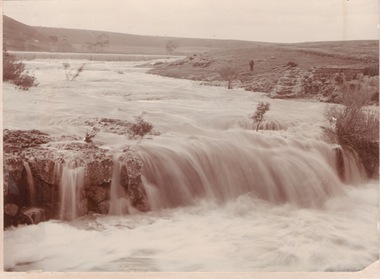 Sunbury Family History and Heritage Society Inc.
Photograph
The waterfalls were on the Jacksons Creek downstream from Sunbury township and in the vicinity of a mill which was built on the river bank. The man standing on the riverbank on the RHS of the image is near the remains of Eadie's Mill which was one of the early structures erected in Sunbury.A sepia photograph mounted on a cream board of two waterfalls in a flooded river with bare hills on either side. A man is standing near some stone ruins on the RHS of the image.waterfalls, jacksons creek, mill falls -
 Lakes Entrance Historical Society
Photograph, Jack Donelly, floods 1998 Lakes Entrance Victoria, 1998 c
Photograph taken from Jemmys PointColour photograph showing discoloured flood water backed up by the incoming tide with fishing boat Crianda shown approaching the Western Pier at the entrance Lakes Entrance Victoriafloods, accommodation -
Tatura Irrigation & Wartime Camps Museum
Photograph, 1955 Tatura Floods, 2001
In 1955 Ross Street North had to be cut to allow flood waters to relieve the flooding of the Tatura Township. The Midland Highway west of the Tatura Undera Road was cut by flood waters.floods 1955, ross st, midland highway, hogan's farm, baldwin road, photograph, people -
 Eltham District Historical Society Inc
Photograph, Floodwaters, Diamond Creek, Eltham, 1934
The Diamond Creek in flood near the Main Road bridge at Eltham, Victoria. The Yarra also was in flood. In early December 1934 the "Greatest flood in the history of the Yarra" occured, according to The Argus newspaper. Bridges and houses were swept away with hundreds of people left homeless across the state. The historic 1934 flood of the Diamond Creek and Yarra River set the criteria for future planning with respect to flood water rise.This photo forms part of a collection of photographs gathered by the Shire of Eltham for their centenary project book, "Pioneers and Painters: 100 years of the Shire of Eltham" by Alan Marshall (1971). The collection of over 500 images is held in partnership between Eltham District Historical Society and Yarra Plenty Regional Library (Eltham Library) and is now formally known as 'The Shire of Eltham Pioneers Photograph Collection.' It is significant in being the first community sourced collection representing the places and people of the Shire's first one hundred years.Digital image 4 x 5 inch B&W Neg (2 frames on one neg) 9 x 15.5 cm B&W printflooding, eltham, shire of eltham pioneers photograph collection, sepp, diamond creek (river), floods, 1934 flood, diamond creek -
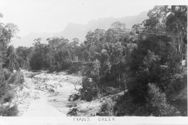 Halls Gap & Grampians Historical Society
Photograph - B/W
Photo shows Fyans Creek, looking South West towards the Pinnacle. View probably taken from the bridge. Fyans Creek appears to be very wide, perhaps after a flood.scenery, fyans creek -
Clunes Museum
Photograph
3 X COLOUR PHOTOGRAPHS TAKEN AT MT CAMERON ROAD BRIDGE OF THE FLOODS OF AUGUST TO SEPTEMBER 2010 PHOTOGRAPHS WERE TAKEN ON 12/08/2010 AND 04/09/2010STICKER ON THE BACK OF PHOTOGRAPH: MC. EILEEN BRADSWORTH, CLUNESflood 2010, mt cameron road bridge -
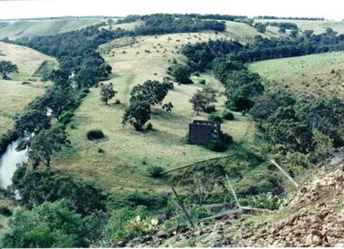 Hume City Civic Collection
Photograph
Lochton Flour Mill was established in the 1850s and is only one of a few surviving mills in Victoria. It is situated on a horseshoe bend on the Deep Creek at Bulla.A coloured photograph of a horse shoe bend in a river and the open flood plain. The river is tree-lined. The ruins of a stone building are on the river bend. A damaged fence and prickly pears are in the foreground.lochton mill, deep creek, hunter, william morrison, george evans collection -
 Eltham District Historical Society Inc
Photograph, Eltham - Floods in 1934
To the left of picture is the Main Road Bridge over the Diamond Creek in Eltham South when the Diamond Creek was in flood. The Yarra also was in flood. In early December 1934 the "Greatest flood in the history of the Yarra" occured, according to The Argus newspaper. Bridges and houses were swept away with hundreds of people left homeless across the state. The historic 1934 flood of the Diamond Creek and Yarra River set the criteria for future planning with respect to flood water rise.This photo forms part of a collection of photographs gathered by the Shire of Eltham for their centenary project book, "Pioneers and Painters: 100 years of the Shire of Eltham" by Alan Marshall (1971). The collection of over 500 images is held in partnership between Eltham District Historical Society and Yarra Plenty Regional Library (Eltham Library) and is now formally known as 'The Shire of Eltham Pioneers Photograph Collection.' It is significant in being the first community sourced collection representing the places and people of the Shire's first one hundred years.Digital image 4 x 5 inch B&W Negsepp, shire of eltham pioneers photograph collection, eltham, diamond creek (river), 1934 flood, diamond creek, floods, main road bridge -
 Orbost & District Historical Society
album, Our Natural Disasters Hailstorm 1991 Floods 1934-1998, between 1998 and 2003?
This album was compiled for the use of visitors to the Slab Hut (Orbost Visitor Information Centre).This album is a useful research tool.A photo album with a maroon cover with gold embossing. On the cover is the title Our Natural Disasters. It contains 54 pages of photos of local natural disasters - flood, fire and hail. The photos are taped in.slab-hut orbost-disasters album orbost-floods-fires-hailstorms -
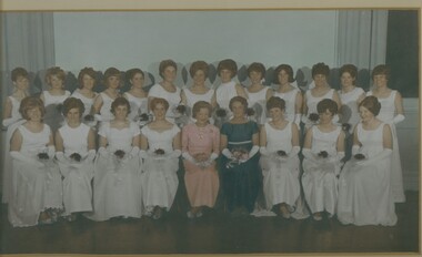 Bendigo Historical Society Inc.
Photograph - MAYORAL DEBUTANTE BALL, 1966-1967
Mayoral Debutante Ball 1960's, colour group photograph of Debutantes seated with Mayoress Mrs Tom Flood, under glass in a white timber frame with gold moulding. Deframed 2022Martin Washingtonphotograph, portrait, female group -
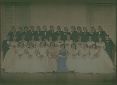 Bendigo Historical Society Inc.
Photograph - MAYORAL DEBUTANTE BALL, 1957-1958
Hand tinted photograph of Debutante Ball in 1950's showing group of Debutantes and partners with Mayoress Mrs Tom Flood, under glass with blond wood timber frame. Deframed 2022Reg Brockphotograph, portrait, group -
Ballarat Heritage Services
Photograph - Colour, Nigretta Falls after heavy rainfall, 2012, 18/08/2012
Colour photographs of Nigretta Falls after heavy rain.nigretta falls, waterfall, flood -
 Ballarat Heritage Services
Photograph - Colour, Floods, Carisbrook, Victoria
carisbrook, flood, flood recovery