Showing 629 items
matching footpaths
-
 Eltham District Historical Society Inc
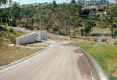
Photograph - Colour Print, Eltham Shire Council, Unidentified road, Eltham district, c.Oct. 1987
Date based on other similar display panels visible in images of the Shire of Eltham display at the Eltham Community Festival, 7 November 1987. 20 x 25 cm Shire of Eltham Engineering Department Providing the resources to undertake • Survey, design, consultation • Road construction and maintenance • Bridge construction and maintenance • Street sweeping • Drain and pit cleaning • Traffic engineering installation and maintenance • Garbage collection • Tip management, land reclamation and beautification • Maintenance of community buildings • Provision of community and recreation facilitiesunidentified, display panel, eltham festival, footpaths and gutters, infrastructure, residential, roads, shire of eltham, streets, 1987 -
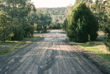 Eltham District Historical Society Inc
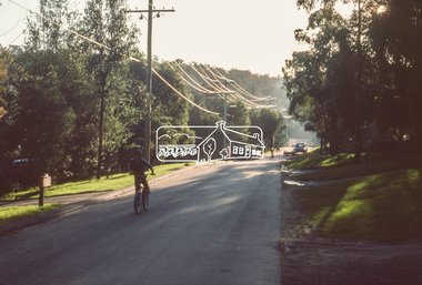
Slide - Photograph, Eltham South Road, c. Jun 1981
Roll of film taken by Eltham Shire Council officers specifically focussed on road infrastructure and maintenance. Many roads of the shire were only relatively recently sealed towards the late 1980s/early 1990s.35 mm colour positive transparency (1 of 8) Mount - Kodak Kodachrome CardProcessed July 1981infrastructure, roads, main road, eltham, footpaths and gutters, unidentified -
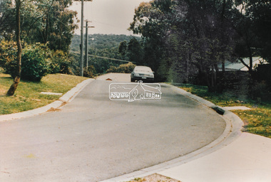
 Eltham District Historical Society Inc
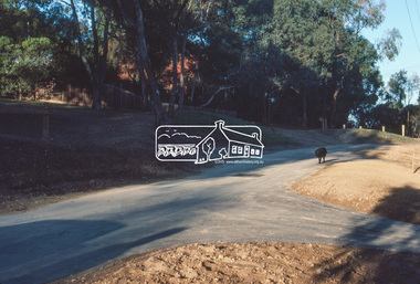
Slide - Photograph, Road infrastucture, new housing development, most likely Templestowe, c.Mar. 1985
Eltham Shire Council officers would benchmark road infrastructure in surrounding local government areas. In this case, the street is most likely a private street scheme in a new housing development in what is present-day Manningham City Council. Areas of interest in the phioto are the roll over concrete kerbs, brick paving at road entrace and drainage.35mm colour positive transparency (1 of 15) Mount - Kodak Kodachrome Cardinfrastructure, roads, city of manningham, footpaths and gutters, housing estates, unidentified, templestowe -
 Eltham District Historical Society Inc
Slide - Photograph, Lomic Court, Templestowe, c.Mar. 1985
Eltham Shire Council officers would benchmark road infrastructure in surrounding local government areas. In this case, a private street scheme in a new housing development on Lomic Court, Telmplestowe in what is present-day Manningham City Council. Areas of interest in the photo are the roll over concrete kerbs, brick paving and drainage.35mm colour positive transparency (1 of 15) Mount - Kodak Kodachrome Cardinfrastructure, roads, city of manningham, footpaths and gutters, housing estates, templestowe, lomic court -
 Eltham District Historical Society Inc
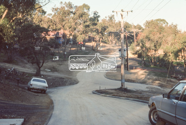
Slide, Main Road, Eltham, c. Jun 1981
Roll of film taken by Eltham Shire Council officers specifically focussed on road infrastructure and maintenance. Many roads of the shire were only relatively recently sealed towards the late 1980s/early 1990s.35 mm colour positive transparency (1 of 8) Mount - Kodak Kodachrome CardProcessed July 1981infrastructure, roads, main road, eltham, footpaths and gutters -
 Eltham District Historical Society Inc
Slide, Main Road, Eltham, c. Jun 1981
Roll of film taken by Eltham Shire Council officers specifically focussed on road infrastructure and maintenance. Many roads of the shire were only relatively recently sealed towards the late 1980s/early 1990s.35 mm colour positive transparency (1 of 8) Mount - Kodak Kodachrome CardProcessed July 1981infrastructure, roads, main road, eltham, footpaths and gutters -
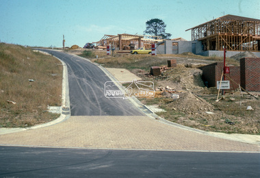
 Eltham District Historical Society Inc
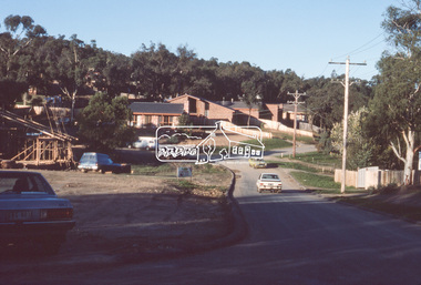
Slide, Quinn Estate, Reichelt Avenue, Montmorency, 15 Sep. 1982
One of a series of images of roads and infrastructure taken by Eltham Shire Council Planning and Engineering officers of the Quinn Estate in Montmorency, Stage 1, Private Street Scheme during construction, September 1982. They provide perspective of the changes in housing styles and road development that began sweeping in from the mid 1970s with increasing urbanisation of what was once more outlying suburbs and regions.35 mm colour positive transparency (1 of15) Mount - Kodak Kodachrome CardProcessed 15 Sep1980housing estate, infrastructure, montmorency, quinn estate, roads, private street scheme, footpaths and gutters, reichelt avenue -
 Eltham District Historical Society Inc
Slide, Adam Crescent, Montmorency, May 1983
One of a series of images of roads and infrastructure taken by Eltham Shire Council Planning and Engineering officers, May 1983 specifically looking at Private Street Schemes post road construction/sealing operations35 mm colour positive transparency (1 of 21) Mount - Kodak Kodachrome Cardroads, infrastructure, adam crescent, footpaths and gutters, montmorency, private street scheme, road sealing -
 Eltham District Historical Society Inc
Slide, Cleveland Avenue, Lower Plenty, May 1983
One of a series of images of roads and infrastructure taken by Eltham Shire Council Planning and Engineering officers, May 1983 specifically looking at Private Street Schemes post road construction/sealing operations35 mm colour positive transparency (1 of 21) Mount - Kodak Kodachrome Cardroads, infrastructure, road sealing, cleveland avenue, footpaths and gutters, lower plenty, private street scheme -
 Eltham District Historical Society Inc
Slide, Quinn Estate, Sackville Street, Montmorency, May 1983
One of a series of images of roads and infrastructure taken by Eltham Shire Council Planning and Engineering officers, May 1983 specifically looking at Private Street Schemes post road construction/sealing operations35 mm colour positive transparency (1 of 21) Mount - Kodak Kodachrome Cardroads, infrastructure, road sealing, footpaths and gutters, private street scheme, housing estate, montmorency, quinn estate, quinn way, sackville street -
 Eltham District Historical Society Inc
Slide, Quinn Estate, Cressy Street, Montmorency, May 1983
One of a series of images of roads and infrastructure taken by Eltham Shire Council Planning and Engineering officers, May 1983 specifically looking at Private Street Schemes post road construction/sealing operations35 mm colour positive transparency (1 of 21) Mount - Kodak Kodachrome Cardroads, infrastructure, road sealing, footpaths and gutters, private street scheme, housing estate, montmorency, quinn estate, cressy street -
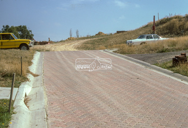
 Eltham District Historical Society Inc
Slide, Quinn Estate, Sackville Street, Montmorency, May 1983
One of a series of images of roads and infrastructure taken by Eltham Shire Council Planning and Engineering officers, May 1983 specifically looking at Private Street Schemes post road construction/sealing operations35 mm colour positive transparency (1 of 21) Mount - Kodak Kodachrome Cardroads, infrastructure, road sealing, footpaths and gutters, private street scheme, housing estate, montmorency, quinn estate, sackville street, t-bowl -
 Eltham District Historical Society Inc
Slide, Quinn Estate, Cressy Street, Montmorency, May 1983
One of a series of images of roads and infrastructure taken by Eltham Shire Council Planning and Engineering officers, May 1983 specifically looking at Private Street Schemes post road construction/sealing operations35 mm colour positive transparency (1 of 21) Mount - Kodak Kodachrome Cardroads, infrastructure, road sealing, footpaths and gutters, private street scheme, housing estate, montmorency, quinn estate, cressy street, quinn way -
 Eltham District Historical Society Inc
Slide, Quinn Estate, Sackville Street, Montmorency, May 1983
One of a series of images of roads and infrastructure taken by Eltham Shire Council Planning and Engineering officers, May 1983 specifically looking at Private Street Schemes post road construction/sealing operations35 mm colour positive transparency (1 of 21) Mount - Kodak Kodachrome Cardroads, infrastructure, road sealing, footpaths and gutters, private street scheme, housing estate, montmorency, quinn estate, sackville reserve, sackville street -
 Eltham District Historical Society Inc
Slide, Frank Street, Eltham, May 1983
One of a series of images of roads and infrastructure taken by Eltham Shire Council Planning and Engineering officers, May 1983 specifically looking at Private Street Schemes post road construction/sealing operations35 mm colour positive transparency (1 of 21) Mount - Kodak Kodachrome Cardroads, infrastructure, road sealing, footpaths and gutters, private street scheme, eltham, frank street -
 Eltham District Historical Society Inc
Slide, Beard Street, Eltham, May 1983
One of a series of images of roads and infrastructure taken by Eltham Shire Council Planning and Engineering officers, May 1983 specifically looking at Private Street Schemes post road construction/sealing operations35 mm colour positive transparency (1 of 21) Mount - Kodak Kodachrome Cardroads, infrastructure, road sealing, footpaths and gutters, private street scheme, eltham, beard street, frank street, shallard avenue -
 Eltham District Historical Society Inc
Slide, Shalbury Avenue, Eltham, May 1983
One of a series of images of roads and infrastructure taken by Eltham Shire Council Planning and Engineering officers, May 1983 specifically looking at Private Street Schemes post road construction/sealing operations35 mm colour positive transparency (1 of 21) Mount - Kodak Kodachrome Cardroads, infrastructure, road sealing, footpaths and gutters, private street scheme, eltham, shalbury avenue -
 Eltham District Historical Society Inc
Slide, Thomas Street, Eltham, May 1983
One of a series of images of roads and infrastructure taken by Eltham Shire Council Planning and Engineering officers, May 1983 specifically looking at Private Street Schemes post road construction/sealing operations35 mm colour positive transparency (1 of 21) Mount - Kodak Kodachrome Cardroads, infrastructure, road sealing, footpaths and gutters, private street scheme, eltham, thomas street -
 Eltham District Historical Society Inc
Slide, Andrews Street, Eltham, May 1983
One of a series of images of roads and infrastructure taken by Eltham Shire Council Planning and Engineering officers, May 1983 specifically looking at Private Street Schemes post road construction/sealing operations35 mm colour positive transparency (1 of 21) Mount - Kodak Kodachrome Cardroads, infrastructure, road sealing, footpaths and gutters, private street scheme, eltham, thomas street -
 Eltham District Historical Society Inc
Slide, Frank Street, Eltham, May 1983
One of a series of images of roads and infrastructure taken by Eltham Shire Council Planning and Engineering officers, May 1983 specifically looking at Private Street Schemes post road construction/sealing operations35 mm colour positive transparency (1 of 21) Mount - Kodak Kodachrome Cardroads, infrastructure, road sealing, footpaths and gutters, private street scheme, eltham, frank street -
 Eltham District Historical Society Inc
Slide, Andrews Street, Eltham, May 1983
One of a series of images of roads and infrastructure taken by Eltham Shire Council Planning and Engineering officers, May 1983 specifically looking at Private Street Schemes post road construction/sealing operations35 mm colour positive transparency (1 of 21) Mount - Kodak Kodachrome Cardroads, infrastructure, road sealing, footpaths and gutters, private street scheme, eltham, andrews street -
 Eltham District Historical Society Inc
Slide, Park Road, Eltham, May 1983
One of a series of images of roads and infrastructure taken by Eltham Shire Council Planning and Engineering officers, May 1983 specifically looking at Private Street Schemes post road construction/sealing operations35 mm colour positive transparency (1 of 21) Mount - Kodak Kodachrome Cardroads, infrastructure, road sealing, footpaths and gutters, private street scheme, eltham, park road -
 Eltham District Historical Society Inc
Slide, Park Road, Eltham, May 1983
One of a series of images of roads and infrastructure taken by Eltham Shire Council Planning and Engineering officers, May 1983 specifically looking at Private Street Schemes post road construction/sealing operations35 mm colour positive transparency (1 of 21) Mount - Kodak Kodachrome Cardroads, infrastructure, road sealing, footpaths and gutters, private street scheme, eltham, park road, t-bowl -
 Eltham District Historical Society Inc
Slide, Frank Street, Eltham, May 1983
One of a series of images of roads and infrastructure taken by Eltham Shire Council Planning and Engineering officers, May 1983 specifically looking at Private Street Schemes post road construction/sealing operations35 mm colour positive transparency (1 of 21) Mount - Kodak Kodachrome Cardroads, infrastructure, road sealing, footpaths and gutters, private street scheme, eltham, frank street -
 Eltham District Historical Society Inc
Slide, Beard Street, Eltham, May 1983
One of a series of images of roads and infrastructure taken by Eltham Shire Council Planning and Engineering officers, May 1983 specifically looking at Private Street Schemes post road construction/sealing operations35 mm colour positive transparency (1 of 21) Mount - Kodak Kodachrome Cardroads, infrastructure, road sealing, footpaths and gutters, private street scheme, eltham, beard street -
 Greensborough Historical Society
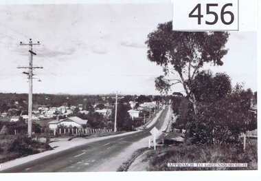
Photograph, Approach to Greensborough, 1947c
A vista of the top end of Greensborough in the late 1940's.Shows the development of Greensborough looking from the Melbourne approach side. Features the early power lines and post and wire fences along Grimshaw Street also dirt edges of the road, early street lighting and no footpaths.A black and white photograph of the approach to Greensborough in the late 1940's.Written in pen on back of photo: "Looking down Grimshaw St from the cutting near William St and Adeline Sts."greensborough, grimshaw street, post war era