Showing 5069 items
matching housing estate
-
 City of Moorabbin Historical Society (Operating the Box Cottage Museum)
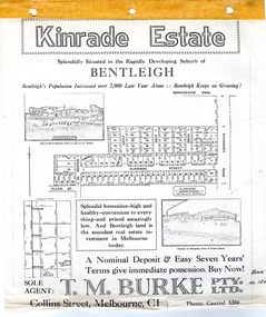
Flyer - Kinrade Estate, Bentleigh East
Kinrade Estate was not subdivided as shown in flyer. The land was purchased by Cyclone in 1950. Cyclone built a factory which manufactured wire material. This factory was closed in XXXX and a development firm purchased the land and subdivided the land into housing blocks.Example of the progress of the Municipality of MoorabbinAdvertising flyer for auction of real estate sales - plan of building blocks for saleleary avenue, charles street, peter leary, john joseph kinrade, tucker road, east boundary road, clover estate, kinrade estate, bentleigh, cyclone company, ardena court, bentleigh east -
 Port Melbourne Historical & Preservation Society
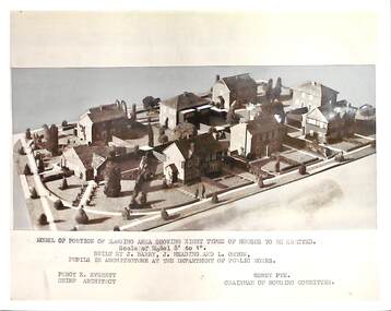
Photograph - Dunstan Estate during construction, Port Melbourne, Department of Public Works, 1936
... dunstan estate percy e everett henry pye albert dunstan Twenty ...Twenty five (25) black and white or sepia photographs of the houses of the Dunstan Estate during their building i.e. Griffin Crescent and Southwood Avenue .16 - .25 - photographs of models made by pupils of Architecture at the Department of Public Works . Shows eight types of houses to be erected. Chief Architect Percy E Everett and Henry Pye the Chairman of the Housing Committee built environment - domestic, domestic life, department of public works, dunstan estate, percy e everett, henry pye, albert dunstan -
 Port Melbourne Historical & Preservation Society
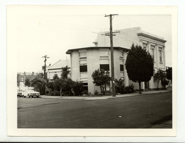
Photograph - Corner Nott and Farrell Streets, Port Melbourne, 1970 - 1979
Photographic images of properties in Port Melbourne. Image may have been taken by a PMHPS member or scanned from a past resident or taken for real estate sale purposes. Corner Nott and Farrell Streets Two images ; 1970s prior to redevelopment of unusual octagonal building; 2012 after redevelopment of public housingbuilt environment - domestic, nott street, farrell street -
 Port Melbourne Historical & Preservation Society
Photograph - Doug McKenzie, Fishermen's Bend estate, Joyce Bennett, 1941
Lasercopy of three snapshots of Doug McKenzie at Fishermen's Bend estate 1941public housing, doug mckenzie, joyce bennett mckenzie -
 Bendigo Historical Society Inc.
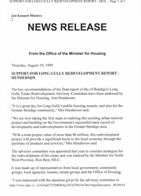
Document - LONG GULLY HISTORY GROUP COLLECTION: SUPPORT FOR LONG GULLY REDEVELOPMENT REPORT - HENDERSON
News Release from the Office of the Minister for Housing, dated August19, 1999 in reference to Support for Long Gully Redevelopment Report - Henderson. The key recommendations of the final report of the Bendigo's Long Gully Estate Redevelopment Advisory Committee have been endorsed by the Minister for Housing, Ann Henderson. There was to be construction of new public and private housing which reflected the current local community needs.bendigo, history, long gully history group, the long gully history group - support for long gully redevelopment report - henderson, office of the minister for housing, ann henderson, ron best mlc, anne stanford -
 Bendigo Historical Society Inc.
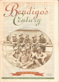
Newspaper - LONG GULLY HISTORY GROUP COLLECTION: BENDIGO'S CENTURY VOLUME FIVE: 1940 - 1949
Newspaper supplement titled Bendigo's Century Volume Five: 1940 - 1949. Each year has heading of Who's Who, Weather, Sport and Business. Front page is titled Bendigo's Century and has a photo of a group of soldiers in uniform and with rifles. They were district servicemen on leave in 1944. Each year has heading of Who's Who, Weather, Sport and Business. First years are 1940 - 1949 titled Bendigo as it was. It has two photos of women wading through the 1949 Pall Mall flood waters and one of Miners in the crib room of the Central Deborah Mine. They are Jackie Lewis, Bob Johnson, W Landy, Ryga Yates and Les Johnson. 1940 - Army moves in to racecourse, 1941 - Devastating fire at pottery, 1942 - Forces expand, 1943 - Nation's eyes on Bendigo, 1944 - News dawns of D-day landing, 1945 - City cheers the end of the war, 1946 - Celebrations begin in city, 1947 - Gallery gets top paintings, 1948 - Water plan looks good and 1949 - Flood takes a toll on city.bendigo, history, long gully history group, the long gully history group - bendigo's century - volume five: 1940 - 1949, bendigo advertiser, central deborah mine, jackie lewis, bob johnson, w landy, ryga yates, les johnson, central nell gwynne, department of defence, bendigo jockey club, 8th division, robert menzies, deborah mine, bendigo decentralisation vigilance committee, cr w h taylor, bendigo war funds organisation, the easter fair society, bendigo agricultural show committee, mr e g ham, mr j v fairbairn, cr a staples, the bendigo chamber of commerce, richard hartley smith abbott, captain harley abbott, bendigo art gallery, bill woodfull, bendigo high school, north deborah mine, boardwalk, toni riley pharmacy, windermere hotel, cr g a pethard, coliban system, north deborah mine, bendigo pottery, bendigo trades hall council, private lawrence burstall, major-general g j rankin mhr, andrew dunstan, ordnance factory, royal australian navy, hmas bendigo, sec offices, muioof, ymca, georger addlem, fred addlem, cr a j anderson, pauline buvhan thompson, leslie thompson, edward joseph leonski, bendigo football league, mr j dedman, william stephens, forest street methodist church, pte charles phillips, pte w e durward, pte t foley, william john stephens, central nell gwynne, air chief marshall sir arthur tedder, cr taylor, united nations, flying officer, r bruce tuff, flight lieutenant owens, royal air force, commonwealth war workers housing trust scheme, mr s mckinnon, bendigo decentralised vigilance committee, ravenswood estate, john lienhop mlc, margaret (peggy) brennan, strathfieldsaye shire council, school of mines, bendigo base hospital, william george ashman, ashman's tailors, bendigo jockey club, victorian football association, bendigo east swimming pool, deborah anticline, specimen hill methodist church, north deborah, adolf hitler, benito mussolini, australian 7th division, cr galvin, bendigo war funds organisation, hmas bendigo, lt-commander jackson, bendigo football league, central deborah mine, victoria day, cr truscott, bendigo gaol, lansellstowe, awas barracks, bendigo citizens committee, john cain snr, ordnance factory, bendigo agricultural society, the duke of gloucester, duchess of gloucester, bendigo tennis association, north deborah, gillies famous pies, aids & appliance shop, mrs georgina scott, dr j a neptune scott, alfred sisley, corot, daubigney, louis sonnenberg, gas employees' union, john lienhop, soldier settlement commission, burnewang estate, king george vi, princess elizabeth, lt philip mountbatten, mr e j w herbert, ansett airways, reg ansett, most rev, dr john mccarthy, dr bernard stewart, michael giudice, bendigo united breweries, bendigo lyric photo plays, bendigo sun newspaper, shamrock hotel, west bendigo progress association, alan mcdonald, south bendigo football club, albert collier, j t webbo, mervyn tresize, state rivers and water supply commission, eppalock reservoir, public works committee, bendigo rotary club, john edgar, bendigo base hospital, albert dunstan, benevolent home, magetti's wine hall, wallace reef wine hall, magetti family, albert magetti, lance galvin, bradford cotton spinnings (victoria) pty otd, arthur syer, stanley crossman, albert arthur dunstan, rev dr henry backhaus, city family hotel, lyric theatre, bank of australasia, city club hotelcolonial mutual building, r matchett & co, lansellstowe, leonard lansell, bendigo bas hospital, australian women's army service, mr hollway, kenworth (aust) ltd, foggitt jones's bacon factory, gordon sayers, sandhurst trustees, dr john drowley, alexander hislop, royal mint, north deborah mine, ironbark south mining company, central nell gwynne company, new chum syncline -
 St Kilda Historical Society
Ephemera - Ticket, Picnic to Park Orchards, 1936
Ticket to picnic at Park Orchards on 21 December 1936, organised by the St Kilda Unemployed Organisation with the support of the St Kilda City Council, Mayor (Cr Alfred Levy), Archie Michaelis MLA, and 'other well-known gentlemen'. The ticket appears to have been perforated to allow vouchers, printed on the back (for bus, dinner, toys, stockings, ice cream and tea) to be separated and used. Park Orchards is a residential suburb 23km north east of Melbourne that was created in 1925 on land used for orchards when timber merchants Australis Sharp and John Taylor launched the Park Orchards Country Club estate. Buyers were not attracted to the estate, and for many years all that existed were a clubhouse and various sporting facilities. It gained popularity when demand for housing surged in the 1950s.Grey/green coloured card, printed in blue on both sides and with 5 evenly spaced lines of perforations across the width.st kilda unemployed organisation, st kilda council -
 Hume City Civic Collection
Photograph, early 1990s
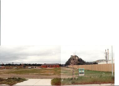
The series of 5 photographs feature different views of the Woodlands housing development which opened up land bounded by Gap and Anderson Roads, Cornish Street and Elizabeth Drive in the early 1990s. It was a large housing development built close to Sunbury township.A view of the northern boundary of the Woodlands housing development in Anderson Road. A paling fence divides the estate from the 'Malley' factory, now 'Storage King' which is on the corner of Cornish Street and Anderson Road. A 'For Sale' sign is in the foreground and a partly built house is in the middle distance.housing developments, anderson road, george evans collection -
Whitehorse Historical Society Inc.
Document, Viewings, 1998
'Viewings', Melbourne Edition One 1998, by Australand, detailing housing developments in Blackburn South, 'Illowra Views', and other areas.fulton road, blackburn south, illowra walk, illowra views, australand, land subdivision, centre road, vermont, arlington heights estate, heatherdale road, rowan street, arlington walk -
Whitehorse Historical Society Inc.
Article, Housing plan for reserve, 2014
... for properties according to Noel Jones Real Estate. Housing plan ...Housing on the Healesville Freeway Reserve .Housing on the Healesville Freeway Reserve could help meet increasing demand for properties according to Noel Jones Real Estate.Housing on the Healesville Freeway Reserve .healesville freeway reserve, noel jones -
 Whitehorse Historical Society Inc.
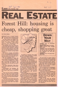
Article, Forest Hill: Housing is cheap, shopping great, 22/04/1990 12:00:00 AM
Sunday Age article about Forest Hill in the Real estate section.Sunday Age article about Forest Hill in the Real estate section. The shopping centre is discussed and the manager, Ms Elaine Forde is interviewed. Comment is made on roads and the quality of the houses.Sunday Age article about Forest Hill in the Real estate section.forest hill, forest hill chase, forde, elaine, parkmore estate, residential development -
Whitehorse Historical Society Inc.
Pamphlet, Smithfield Walk, Vermont, n.d
... Estate Vermont Advertisement for housing development: 'Homestead ...Advertisement for housing development: 'Homestead Rise' at Smithfield Walk, Vermont. Land originally owned by L.L. Smith; purchased in 1924 by David Hastie Harvie. Developer: Residential Developments Australia Pty Ltd.auctions, smithfield walk, vermont, harvie, david hastie, residential developments australia pty ltd, homestead rise estate, vermont -
 RMIT Design Archives
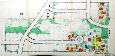
Work on paper - Architectural drawings, Colour plan of Lum road estate, 1970-1986
This plan of Lum Road Estate includes layout of roads, gardens, building and carparks. From 1970 until August 1971 Robin Boyd and his practice Romberg & Boyd Architects worked on designs for housing on the Lum Road Estate, Wheelers Hill. Berenice Harris, Linley Vellacott and Karl Fender drew many of the sketch plans for the project homes, while Robin Boyd drew the perspectives. This colour plan of the estate was drawn by Robin Boyd, but not signed. Frederick Romberg later annotated the drawing with details of its authorship. Colour plan of Lum road estate. Includes layout of roads, gardens, buildings and flora.Inscribed lower right on recto in black ink, 'Robin Boyd original / 12/6/86 F.R' ; Inscriber upper left on recto, grey pencil, '3400'.architecture, design, rmit design archives, domestic architecture -
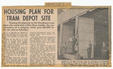 Ballarat Tramway Museum
Newspaper, The Courier Ballarat, "Housing plan for tram depot site", 19/06/1972 12:00:00 AM
Newspaper clipping from The Courier, Ballarat, dated Monday, June 19, 1972 titled "Housing plan for tram depot site". Reports on the sale of the former tram depot on Saturday June 17 for $54,500. The purchaser expected to start development of housing on the site within three months. Reports on the sale, purchaser and SEC's views. Features a photo of Edgar Bartrop reading the contract. Others in the photo are Bruce Bartrop, SEC Estate officer, Mr. R. Morrison and SEC Manager Mr. I. F. Pellas. One of a large group of newspaper cuttings from John Bainbridge, 7/4/02.depot, buildings, auctions, bartrop -
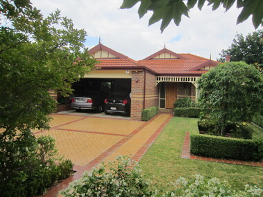
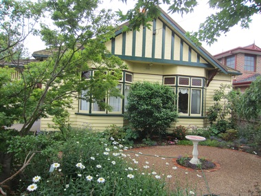
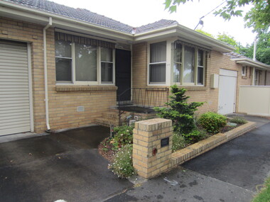
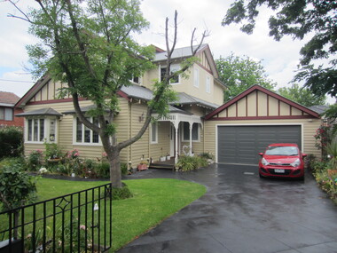
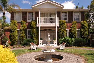
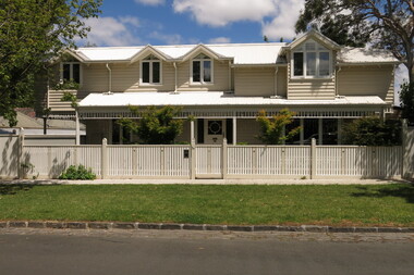
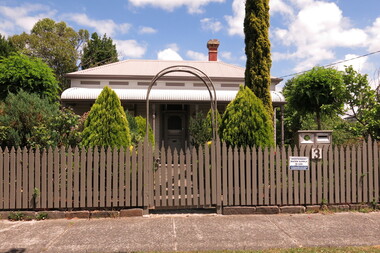
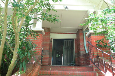
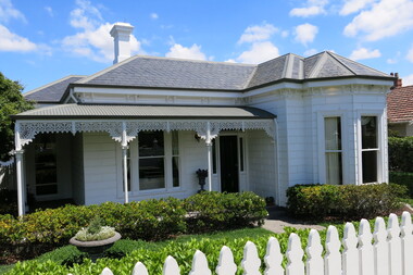
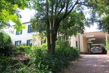
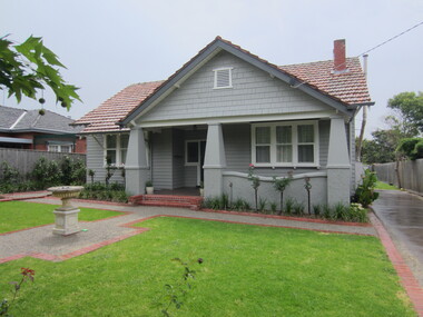 Surrey Hills Historical Society Collection
Photograph - 109 Middlesex Road, Surrey Hills, The Street Where You Live Project
Photos documenting this address as part of a photographic series undertaken by volunteer photographers during 2013 and 2014 for The Street Where You Live Project. This was organised through the Surrey Hills Neighbourhood Centre and covered the postcode 3127 in the cities of Boroondara and Whitehorse.These photos provide a snapshot of real estate in the suburbs of Mont Albert and Surrey Hills during a period of rapid change with many properties on large blocks demolished to create higher density residential development or renewal of single dwellings. At particular risk were properties not covered by heritage overlays, in particular interwar housing and post 1950's housing. -
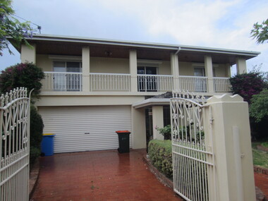
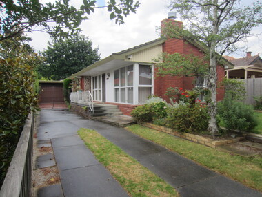 Surrey Hills Historical Society Collection
Photograph - 110 Middlesex Road, Surrey Hills, The Street Where You Live Project
Photos documenting this address as part of a photographic series undertaken by volunteer photographers during 2013 and 2014 for The Street Where You Live Project. This was organised through the Surrey Hills Neighbourhood Centre and covered the postcode 3127 in the cities of Boroondara and Whitehorse.These photos provide a snapshot of real estate in the suburbs of Mont Albert and Surrey Hills during a period of rapid change with many properties on large blocks demolished to create higher density residential development or renewal of single dwellings. At particular risk were properties not covered by heritage overlays, in particular interwar housing and post 1950's housing. -
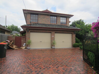
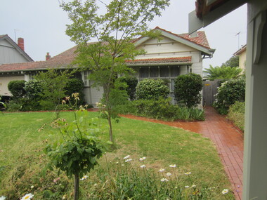 Surrey Hills Historical Society Collection
Photograph - 111 Middlesex Road, Surrey Hills, The Street Where You Live Project
Photos documenting this address as part of a photographic series undertaken by volunteer photographers during 2013 and 2014 for The Street Where You Live Project. This was organised through the Surrey Hills Neighbourhood Centre and covered the postcode 3127 in the cities of Boroondara and Whitehorse.These photos provide a snapshot of real estate in the suburbs of Mont Albert and Surrey Hills during a period of rapid change with many properties on large blocks demolished to create higher density residential development or renewal of single dwellings. At particular risk were properties not covered by heritage overlays, in particular interwar housing and post 1950's housing. -
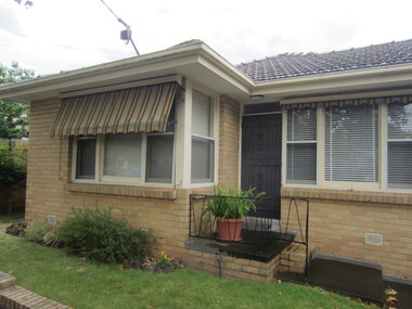
 Surrey Hills Historical Society Collection
Photograph - 112 Middlesex Road, Surrey Hills, The Street Where You Live Project
Photos documenting this address as part of a photographic series undertaken by volunteer photographers during 2013 and 2014 for The Street Where You Live Project. This was organised through the Surrey Hills Neighbourhood Centre and covered the postcode 3127 in the cities of Boroondara and Whitehorse.These photos provide a snapshot of real estate in the suburbs of Mont Albert and Surrey Hills during a period of rapid change with many properties on large blocks demolished to create higher density residential development or renewal of single dwellings. At particular risk were properties not covered by heritage overlays, in particular interwar housing and post 1950's housing. -
 Surrey Hills Historical Society Collection
Photograph - 113 Middlesex Road, Surrey Hills, The Street Where You Live Project
Photos documenting this address as part of a photographic series undertaken by volunteer photographers during 2013 and 2014 for The Street Where You Live Project. This was organised through the Surrey Hills Neighbourhood Centre and covered the postcode 3127 in the cities of Boroondara and Whitehorse.These photos provide a snapshot of real estate in the suburbs of Mont Albert and Surrey Hills during a period of rapid change with many properties on large blocks demolished to create higher density residential development or renewal of single dwellings. At particular risk were properties not covered by heritage overlays, in particular interwar housing and post 1950's housing. -
 Surrey Hills Historical Society Collection
Photograph - 114 Middlesex Road, Surrey Hills, The Street Where You Live Project
Photos documenting this address as part of a photographic series undertaken by volunteer photographers during 2013 and 2014 for The Street Where You Live Project. This was organised through the Surrey Hills Neighbourhood Centre and covered the postcode 3127 in the cities of Boroondara and Whitehorse.These photos provide a snapshot of real estate in the suburbs of Mont Albert and Surrey Hills during a period of rapid change with many properties on large blocks demolished to create higher density residential development or renewal of single dwellings. At particular risk were properties not covered by heritage overlays, in particular interwar housing and post 1950's housing. -
 Surrey Hills Historical Society Collection
Photograph - 115 Middlesex Road, Surrey Hills, The Street Where You Live Project
Photos documenting this address as part of a photographic series undertaken by volunteer photographers during 2013 and 2014 for The Street Where You Live Project. This was organised through the Surrey Hills Neighbourhood Centre and covered the postcode 3127 in the cities of Boroondara and Whitehorse.These photos provide a snapshot of real estate in the suburbs of Mont Albert and Surrey Hills during a period of rapid change with many properties on large blocks demolished to create higher density residential development or renewal of single dwellings. At particular risk were properties not covered by heritage overlays, in particular interwar housing and post 1950's housing. -
 Surrey Hills Historical Society Collection
Photograph - 116 Middlesex Road, Surrey Hills, The Street Where You Live Project
Photos documenting this address as part of a photographic series undertaken by volunteer photographers during 2013 and 2014 for The Street Where You Live Project. This was organised through the Surrey Hills Neighbourhood Centre and covered the postcode 3127 in the cities of Boroondara and Whitehorse.These photos provide a snapshot of real estate in the suburbs of Mont Albert and Surrey Hills during a period of rapid change with many properties on large blocks demolished to create higher density residential development or renewal of single dwellings. At particular risk were properties not covered by heritage overlays, in particular interwar housing and post 1950's housing. -
 Surrey Hills Historical Society Collection
Photograph - 117 Middlesex Road, Surrey Hills, The Street Where You Live Project
Photos documenting this address as part of a photographic series undertaken by volunteer photographers during 2013 and 2014 for The Street Where You Live Project. This was organised through the Surrey Hills Neighbourhood Centre and covered the postcode 3127 in the cities of Boroondara and Whitehorse.These photos provide a snapshot of real estate in the suburbs of Mont Albert and Surrey Hills during a period of rapid change with many properties on large blocks demolished to create higher density residential development or renewal of single dwellings. At particular risk were properties not covered by heritage overlays, in particular interwar housing and post 1950's housing. -
 Surrey Hills Historical Society Collection
Photograph - 118 Middlesex Road, Surrey Hills, The Street Where You Live Project
Photos documenting this address as part of a photographic series undertaken by volunteer photographers during 2013 and 2014 for The Street Where You Live Project. This was organised through the Surrey Hills Neighbourhood Centre and covered the postcode 3127 in the cities of Boroondara and Whitehorse.These photos provide a snapshot of real estate in the suburbs of Mont Albert and Surrey Hills during a period of rapid change with many properties on large blocks demolished to create higher density residential development or renewal of single dwellings. At particular risk were properties not covered by heritage overlays, in particular interwar housing and post 1950's housing. -
 Surrey Hills Historical Society Collection
Photograph - 1 St Georges Avenue, Mont Albert, The Street Where You Live Project
Photos documenting this address as part of a photographic series undertaken by volunteer photographers during 2013 and 2014 for The Street Where You Live Project. This was organised through the Surrey Hills Neighbourhood Centre and covered the postcode 3127 in the cities of Boroondara and Whitehorse.These photos provide a snapshot of real estate in the suburbs of Mont Albert and Surrey Hills during a period of rapid change with many properties on large blocks demolished to create higher density residential development or renewal of single dwellings. At particular risk were properties not covered by heritage overlays, in particular interwar housing and post 1950's housing. -
 Surrey Hills Historical Society Collection
Photograph - 1A St Georges Avenue, Mont Albert, The Street Where You Live Project
Photos documenting this address as part of a photographic series undertaken by volunteer photographers during 2013 and 2014 for The Street Where You Live Project. This was organised through the Surrey Hills Neighbourhood Centre and covered the postcode 3127 in the cities of Boroondara and Whitehorse.These photos provide a snapshot of real estate in the suburbs of Mont Albert and Surrey Hills during a period of rapid change with many properties on large blocks demolished to create higher density residential development or renewal of single dwellings. At particular risk were properties not covered by heritage overlays, in particular interwar housing and post 1950's housing. -
 Surrey Hills Historical Society Collection
Photograph - 3 St Georges Avenue, Mont Albert, The Street Where You Live Project
Photos documenting this address as part of a photographic series undertaken by volunteer photographers during 2013 and 2014 for The Street Where You Live Project. This was organised through the Surrey Hills Neighbourhood Centre and covered the postcode 3127 in the cities of Boroondara and Whitehorse.These photos provide a snapshot of real estate in the suburbs of Mont Albert and Surrey Hills during a period of rapid change with many properties on large blocks demolished to create higher density residential development or renewal of single dwellings. At particular risk were properties not covered by heritage overlays, in particular interwar housing and post 1950's housing. -
 Surrey Hills Historical Society Collection
Photograph - 4 St Georges Avenue, Mont Albert, The Street Where You Live Project
Photos documenting this address as part of a photographic series undertaken by volunteer photographers during 2013 and 2014 for The Street Where You Live Project. This was organised through the Surrey Hills Neighbourhood Centre and covered the postcode 3127 in the cities of Boroondara and Whitehorse.These photos provide a snapshot of real estate in the suburbs of Mont Albert and Surrey Hills during a period of rapid change with many properties on large blocks demolished to create higher density residential development or renewal of single dwellings. At particular risk were properties not covered by heritage overlays, in particular interwar housing and post 1950's housing. -
 Surrey Hills Historical Society Collection
Photograph - 5 St Georges Avenue, Mont Albert, The Street Where You Live Project
Photos documenting this address as part of a photographic series undertaken by volunteer photographers during 2013 and 2014 for The Street Where You Live Project. This was organised through the Surrey Hills Neighbourhood Centre and covered the postcode 3127 in the cities of Boroondara and Whitehorse.These photos provide a snapshot of real estate in the suburbs of Mont Albert and Surrey Hills during a period of rapid change with many properties on large blocks demolished to create higher density residential development or renewal of single dwellings. At particular risk were properties not covered by heritage overlays, in particular interwar housing and post 1950's housing. -
 Surrey Hills Historical Society Collection
Photograph - 6 St Georges Avenue, Mont Albert, The Street Where You Live Project
Photos documenting this address as part of a photographic series undertaken by volunteer photographers during 2013 and 2014 for The Street Where You Live Project. This was organised through the Surrey Hills Neighbourhood Centre and covered the postcode 3127 in the cities of Boroondara and Whitehorse.These photos provide a snapshot of real estate in the suburbs of Mont Albert and Surrey Hills during a period of rapid change with many properties on large blocks demolished to create higher density residential development or renewal of single dwellings. At particular risk were properties not covered by heritage overlays, in particular interwar housing and post 1950's housing.