Showing 25223 items
matching north or new hustlers (agnew hustler)
-
 Ringwood and District Historical Society
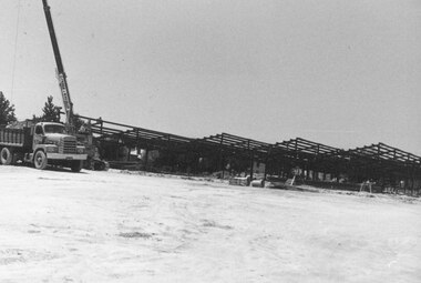
Photograph, New Ringwood Market building under construction, looking north from Charter Street - 15/1/1982
Written on back of photograph, "E653. N68A. 15/1/82. Work on new market building looking north from Charter St." -
 Ringwood and District Historical Society
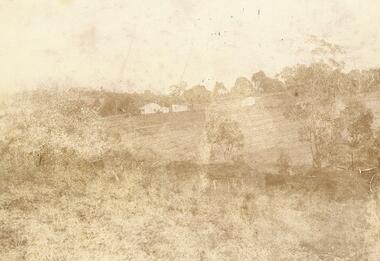
Photograph, "Quambee", North Ringwood, 1912 - viewed from Coombes' property
Sepia photograph showing the house and buildings in the distance.Written on rear of photograph: "Quambee, North Ringwood, 1912 - from Coombes' property." Quambee was owned by Augustus Temple Miles until 1916. -
 National Vietnam Veterans Museum (NVVM)
Photograph, Engineers at work Vietnam 1968, 1968
Coloured photograph,print in black frame with mushroom brown mat under glass.Photograph depicts a hovering helicopter and a crane arm. Engineers constructing a tower, four men work on top of the towers legs. Several others on the ground. Background helicopter holding / moving part of contruction piece.My Vietnam Collection Engineers at work.- Vietnam 1968.Copyright John Dalton Gift Horse Gallery / Fine art / original works by local and interstate artists professional picture framers.CRN Paxton St. 130 Main North Rd, Clare SA 5453.Phone / Fax/ Mob.photograph, engineers, helicopter -
 Greensborough Historical Society
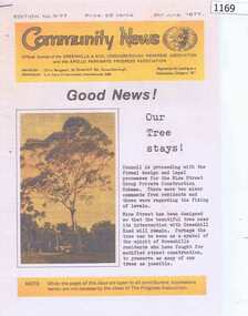
Newsletter, Greenhills and North Greensborough Progress Association, Community News . June 1977, 08/06/1977
Community News was the official journal of the Greenhills and North Greensborough Progress Association and the Apollo Parkways Progress Association. These copied pages report on the preservation of a tree in Mine Street and a group of locals reminiscing about life in Greenhills in the 1930s and 1940s.Copy of 3 pages, illus. greenhills, greenhills and north greensborough progress association -
 Buninyong & District Historical Society
Photograph - Photograph of Original Postcard, Derek Leather, North side Warrenheip St. 1970's, looking east towards Mount Buninyong, 1970-80's
Historic BuildingsB/W Photo North side Warrenheip St. 1970's, looking east towards Mount Buninyong down service road, corner shop to supermarketbuninyong, learmonth st., corner shop -
 Whitehorse Historical Society Inc.
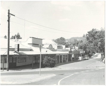
Document, Blackburn North Progress Association, 1953-1969
Blackburn North Progress Association papers incl. Minutes and Account books of the Association and its Ladies Auxiliary and Social Committee.Blackburn North Progress Association papers incl. Minutes and Account books of the Association and its Ladies Auxiliary and Social Committee. See list of Contents in box for details.Blackburn North Progress Association papers incl. Minutes and Account books of the Association and its Ladies Auxiliary and Social Committee.blackburn north progress association, minutes, account books -
 Whitehorse Historical Society Inc.
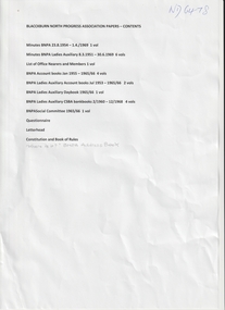
Article, North East Link Update, 2019
The alliance of Boroondara, Banyule and Whitehorse councils have been presenting concerns about option A to the North East Link Inquiry and Advisory Committee regarding the impact on the community.The alliance of Boroondara, Banyule and Whitehorse councils have been presenting concerns about option A to the North East Link Inquiry and Advisory Committee regarding the impact on the community.The alliance of Boroondara, Banyule and Whitehorse councils have been presenting concerns about option A to the North East Link Inquiry and Advisory Committee regarding the impact on the community.north east link, freeways -
 Kew Historical Society Inc
Photograph, Floods in North Kew, 1971
Living with natural processes was frequently a challenge to early European settlers and later residents of what was in the 1850s administered by the Borondara Road Board. This was compounded by the area being bounded on three sides by rivers (Yarra River, Koonung Creek and Gardiner's Creek). In 1849, the historian James Bonwick recorded that "our district [Kew] suffered considerably. Mr Wade speaks of 80 acres, out of 100 acres of his cultivated paddock, covered by water." Newspapers continued to describe major flooding in Kew in 1863, 1869, 1878, 1880, 1889, 1891, 1916 and 1934. While the construction of the Upper Yarra dam in 1957 reduced the levels of flowing downstream, local and riverine floods continue.The Kew Historical Society's pictures and map collections testify to the impact of flooding in the district. They have historical importance in documenting the extent of flooding in the district and its affects on homes, services and recreation. Numerous photographs record flooding throughout the Twentieth Century.Floods in North Kew, 1971. Looking northeast towards Kilby Road from River Avenue. Annotation on reverse: map and date "8 Nov. 71 10.30am".floods (kew), yarra river, kew flood, kilby road flood -
 Lakes Entrance Historical Society
Book, Reid Richard Page Courtney Pounds Robert, Laden, Fevered, Starved. The POWs of Sandakan, North Borneo, 1945, 1999
An account of the atrocities suffered by Australian POWs of the Japanese in the Sandakan, North Borneo prison camp, and the Sandakan-Ranau death marches. Includes War Memorials, illustrated with photographs.military history, memorials -
Lakes Entrance Historical Society
Photograph, Judy Davies, Small blue album of North Arm bridge: Lakes Entrance Victoria, 2010
Small blue album containing twenty eight colour photographs of North Arm from bridge to Cabaritor Point showing new residential sites at Kalimna Victoriaengineering, historic site -
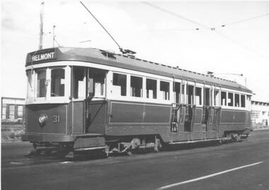 Ballarat Tramway Museum
Photograph - Black & White Photograph/s, Leon Marshall-Wood, 29/03/1948 12:00:00 AM
Yields information about Geelong trams in the late 1940's and the bogie trams.Black and white print of Geelong 31 at the North terminus. The tram has the destination of Belmont. Photo dated 29/3/1948. Based on the handwriting on btm5869i, the photo is by Leon Marshal-Wood. Negative scanned at 3200dpi 9/6/2020 9/6/2020.On the rear in pencil "29/3/1948, X HTT, North Terminus Geelong"trams, tramways, geelong, north, belmont, tram 31 -
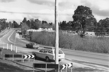 Ringwood and District Historical Society
Photograph, Junction of Warrandyte Road, Old Warrandyte Road and Tortice Drive, North Ringwood looking south 1981
Written on back of photograph, "19/6/81. The junction of Warrandyte Road, Old Warrandyte Road and Tortice Drive, North Ringwood looking south." -
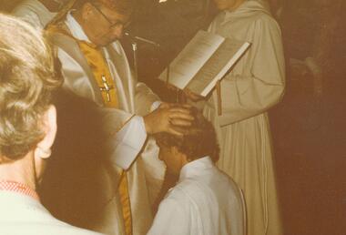 Ringwood and District Historical Society
Photograph, Ordination of Len Phillips as a Deacon - Holy Spirit Parish, North Ringwood, 20/9/1981, 1981
Two colour photographs of religious ceremony.Written on back of photograph, 'Holy Spirit Parish, North Ringwood 20/9/81. Bishop ordains Len Phillips as a Deacon. The laying on of hands.' -
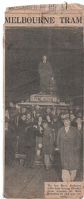 Melbourne Tram Museum
Newspaper, The Argus, "Last North Melbourne Tram", 22/07/1935 12:00:00 AM
Newspaper Clipping - from The Argus Monday 22/7/1935 titled "Last North Melbourne Tram", about the closure of the North Melbourne cable tram line in Lonsdale St from Elizabeth St. Part of the heading has been cut off. Shows many people gathered around the tram including people n the roof. A check with Trove, shows that the photo appeared on page 7 of the newspaper.trams, tramways, elizabeth st, closure, cable trams, north melbourne, last tram -
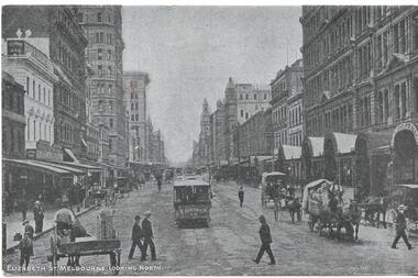 Melbourne Tram Museum
Postcard, "Elizabeth St Melbourne looking North", 1900's
Postcard - silver finish known as "Collotype" - view of looking north along Elizabeth St from Flinders St. Shows the cable tram terminus with a Brunswick tram ready to depart. Has a number of horse drawn carts in the view. Card titled "Elizabeth St Melbourne looking North" Postcard has a divided back with space for stamp, address and correspondence. In the top centre is a start with an "O" in the centre.trams, tramways, cable trams, elizabeth st, flinders st -
 Clunes Museum
Photograph, BEAUCHAMP PHOTOGRAPHY, CIRCA 1881-82
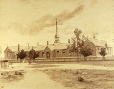
NORTH CLUNES STATE SCHOOL NO. 1552, BRICK BUILDING - BUILT 1875. LATER BECAME HIGHER ELEMENTARY SCHOOL, LATER AGAIN - A CONSOLIDATED SCHOOL.ORIGINAL SEPIA PHOTOGRAPH OF NORTH STATE SCHOOL - BUILT 1875. AND FIVE BLACK AND WHITE PHOTOCOPIES, LATER IT BECAME THE HIGHER ELEMENTARY SCHOOL AND LATER AGAIN A CONSOLIDATED SCHOOL.THE STATE SCHOOL, NORTH CLUNES.local history, 1552, north clunes state school -
 Ringwood and District Historical Society
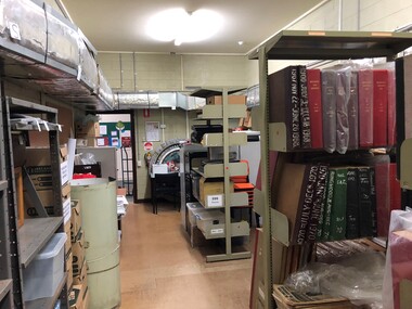
Photograph - Multiple, Ringwood Historical Society Parkwood Archives Store (North Ringwood) , August 2019, 3/8/2019
This store is used by Ringwood and District Historical Society for larger archive items, newspapers, and cartons of material yet to be catalogued. A group of digital photos of the RDHS Parkwood Archive Store in the Parkwood Community Hub, 35-39 Tortice Dr, Ringwood North VIC 3134. Taken by Ken Briscoe -
 Ringwood and District Historical Society
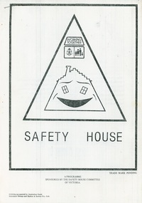
Document - Minutes and papers, North Ringwood Community Safety House 1983
Papers pertaining to North Ringwood Safety House minutes of meeting 9 February 1983, 2 March 1983 and porposed "Safety home" programme. Stranger Awareness survey. -
Whitehorse Historical Society Inc.
Document, Bridgegord Avenue, Blackburn North, 1/03/2000
Auction brochure for 2 bedroom brick veneer house at 4 Bridgeford Avenue, Blackburn North for auction 25 March 2000. Agents: Whitehorse Partners First National.bridgeford avenue, blackburn north, no 4, auctions -
 Melbourne Tram Museum
Photograph - Black & White Photograph/s, The North Melbourne & Essendon Tramways and Lighting Co. Ltd (NMETL), 1906
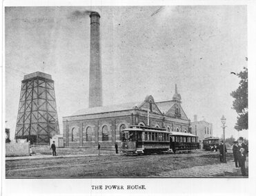
Photographs, Black and White, Group Photo of The North Melbourne Electric Tramways and Lighting Co (NMETL) Power station at Essendon Depot. Has the power station, chimney and cooling tank in the view along with Saloon motor No. 9 with a trailer and a toastrack type tram, possibly No. 15. Dated 1906. Toast rack. Mt Alexander Road. Photo from an illustration with "The Power House" along the bottom edge.In ink on the rear: Keith Kings stamp and number S-A-482 "NMET&L Co. Saloon motor No. 9 and trailer and toastrack motor (No. 15?) outside depot showing Power House, Tank and Offices. 1906"trams, tramways, nmetl, depot, mt alexander road, essendon depot, power station, tram 9 -
 Melbourne Tram Museum
Postcard, Wayne Zerbe / North Australian Trading Co. for Kangaroo Gifts, Melbourne views including trams, early 1990's
Colour postcard, three panels: 1 - B class turning from Bourke into Spring St 2 - Walkway bridge (Evan Walker Bridge) over the Yarra 3 - City Skyline Back has space for name and address, stamp and a message and details of the postcard. Produced by Wayne Zerbe / North Australian Trading Co. for Kangaroo Gifts. Card No. KGL8 Has "Melbourne Australia" along the bottom edge.trams, tramways, bourke st, b class, melbourne -
 Melbourne Tram Museum
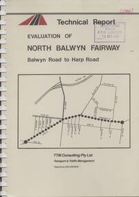
Document - Report, TTM Consulting, "Evaluation of North Balwyn Fairway, Balwyn Road to Harp Road", May. 1985
Approx a 70 page, comb bound, report by TTM Consulting in May 1985, titled "Evaluation of North Balwyn Fairway, Balwyn Road to Harp Road" for the Public Transport Corporation. Evaluates the impact of a Fairway along the North Balwyn tram route. Principal conclusions given on page - tram travel times in both AM and PM peaks were virtually unchanged. Document has many tables at rear, graphs and maps.Stamped on cover and inside page "Discarded from PTC Library 19 Oct 1989" and "1985" in red ink on front cover.trams, tramways, north balwyn, fairways, traffic control, tram priority -
Whitehorse Historical Society Inc.
Document, Surrey Road, Blackburn North, 1/02/2000
Auction brochure for 3 bedroom weatherboard house at 90 Surrey Road, Blackburn North, for auction 12 February 2000. Agent: Whitehorse Partners First National, Box Hill.surrey road, blackburn north, no 90, auctions -
 Buninyong & District Historical Society
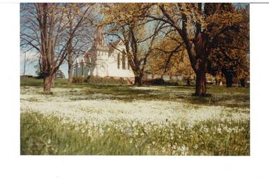
Photograph - Original Colour Photograph, Buninyong Uniting Church (formerly Presbyterian, 1860), north side, from Learmonth St, 1982
Record of Victorian era church in 1980's. Colour photo, Buninyong Uniting Church (formerly Presbyterian, 1860), north side, from Learmonth St. Viewed through trees that are coming into leaf, lawn carpeted in white flowers.uniting church, presbyterian church, learmonth st., trees, flowers -
 Mt Dandenong & District Historical Society Inc.
Photograph, Post Office and 'Mountjoy', Mt. Dandenong North, 1913
Rose Series post card #182Copy of Rose Series postcard #182 showing Kalorama Gap in 1913. Haystacks in foreground with Mountjoy Guest House and Beulah Tea Rooms/Mt Dandenong North Post Office in centre. This photograph has a detailed inscription on the back handwritten by John Lundy-Clarke in 1974.Kalorama Gap in 1913 The elm trees are in the centre of the picture. One of these is really two as two suckers of the further tree were twisted together by Fred Jeeves in 1898 and grew as one tree. The other was planted in 1880. The shop is the shop of Mrs Eliza Hand and daughter Florence. The closed in far end of the verandah was the Mount Dandenong North Post Office. The large house is “Mountjoy” owned and run by the Jeeves Family from 1908 till 1943. It was built in 1905 by the Paynters who sold to Ellis Jeeves in 1908.He moved his line of coaches from “Kalorama” his old homestead and housed the horses in a line of stables behind “Mountjoy”. Price’s house, which contained their shop, the first one on the mountain, opened 1906, can be seen faintly behind the pine tree opposite the bend in the road, which was the main road then and now is Ridge Road. The Price’s house just shows in two tiny pieces, one on each side of the pine tree half way up. The house to the right of and high up the pine tree is Walker’s cottage which exists today opposite Jack Kidd’s home at the far edge of Lt 2 Village Settlement and was between Main Road and Barbers Road which runs down the left behind the elms. Walker’s homestead can be seen near left edge of picture 2/3 way up. The roof of the Methodist Church shows among trees left of picture. This, like Mrs Hand’s shop was built on portions separated from Isaac Jeeves’ Selection “C” known as Jeeves Saddle. kalorama gap, five ways, mountjoy, john lundy-clarke, beulah tea rooms, post office, fred jeeves, paynter, jeeves, frederick jeeves, price, walker, jack kidd -
 Ringwood and District Historical Society
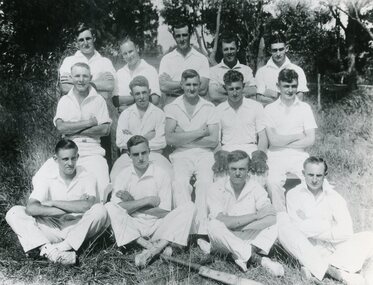
Photograph, North Ringwood Cricket Club team - 1935-36
Black and white photograph"Attached to photograph" North Ringwood Cricket Club. 1935-36. Runners up, 'B' Grade, R.D.C.A. Names of team members included. Refer 10283(a) -
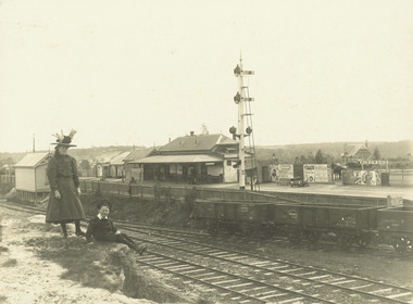 Ringwood and District Historical Society
Photograph, Ringwood Railway Station from Station St. looking north west - c.1910
Black and white photographs (2 copies - 1 original, 1 copy)Typed below photograph, "Ringwood Railway Station from Station St. looking north west. Old state school in background at Right. (App. 1910)". -
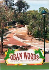 Ringwood and District Historical Society
Document - Land Sale Folder, Oban Woods Subdivision, Ringwood North, Vic., - circa 1997
Folder containing multi-fold colour pamphlet advertising Lots 6 to 12 of Oban Woods Estate with location map and summary of subdivision features. A4 size attachments include subdivision layout of Lots 2 to 25 with summary of property sizes and undated indications of whether sold or still available at the time, with price where known. Dates not documented however early sales within the development took place around 1997.Estate plan includes Oban Woods (thoroughfare) and Chifley Parade. Location map of area shows development site of Oban Woods Estate off Oban Road and Kubis Drive, Ringwood North. Agents - R.E. Appleby Ringwood Pty Ltd., 170 Warrandyte Road Ringwood North 3134, Telephone 9876 4222, Fax 9876 4209. -
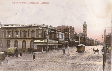 Ballarat Tramway Museum
Postcard, Ballarat Litho & Printing Co, Lydiard St North, 1905
Yields information about the corner of Mair and Lydiard St soon after the Ballarat Electric Tramway opened.Digital Image of and ESCo tram north bound in Lydiard St North, at the intersection with Mair St. Shows the Ballarat Litho and Printing Co Propy Ltd building on the corner. Note the centre poles and the pole in the middle of the intersection. Has a number of horse drawn vehicles. Photo taken soon after opening as the destination sign is on the dash panel. From the Facebook group of old time photographs of yesterday. Titled "Lydiard St Ballarat Victoria"trams, tramways, mair st, lydiard st north, esco, postcards -
 Eltham District Historical Society Inc
Book, Jenny Brown et al, Out of the Mist; Osborne Peninsula, 2024
The Osborne Peninsula on the Yarra River at Warrandyte accommodates a limited number of properties and residents (70 households). The area is rich in geology and ecology, and an unusually rich endowment of human, built and creative history. Contents: Welcome: The landform: The River: Aboriginal occupation: The Miners: North Warrandyte :The Subdivision: The Lowes: The Osbornes: The Last Osborne: The Elders: The Relics: Dray Track: Water Wheel"Kauri Plaque: River track: Pines: Windmill Creek Bridge: The Koornong School: The Houses" Man Cave: MidCentury Classic: Enduring Original" Masterwork: The Muddies: The State Park: The Saving of Koornong Reserve: The Landcare Story: Flora and Fauna: The Vulnerable, Endangered and threatened: Birds: Mammals: "Waring" the wombat: Reptiles: Fish: Invertebrates: Flora: Fire. Published by the North Warrandyte (Osborne Peninsula) Landcare Group. Includes photos from EDHS collection.64 p. : ill., map ; 29.7 x 21 cm. (2 copies)yarra river, birrarung, dray track, fauna, geology, houses, indigenous history, koornong reserve, koornong school, lowe family, mining, mudbrick houses, north warrandyte, osborne family, warrandyte state park, water wheel, north warrandyte (osborne peninsula) landcare group, osborne peninsula