Showing 2276 items
matching parish.
-
 Ringwood and District Historical Society
Document, Plan of Subdivision - Part of Crown Portion 5, Parish of Ringwood, County of Bourke - (Undated)
Map showing layout of 4 numbered allotments coloured red and land coloured blue appropriated or set aside for drainage and sewerage puposes.Map includes Nelson Street and Ringwood Street, Ringwood, Vic. -
 Ringwood and District Historical Society
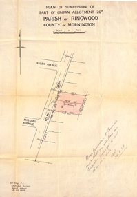
Document, Plan of Subdivision - Part of Crown Allotment 26A, Parish of Ringwood, County of Mornington - Circa 1961
Map showing layout of 2 allotments coloured red in Velma Grove, adjacent to Valda Avenue and Mirabel Avenue, Ringwood East, Vic.Handwritten notation dated 29/8/1961 by Alf King, Licensed Surveyor, 14 Grace Street, Mont Albert (Phone) WX2020 regarding plans being forwarded to Council for inspection visit. -
 Ringwood and District Historical Society
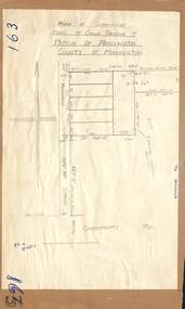
Map - Plan of Subdivision, Part of Crown Portion 7, Parish of Ringwood, County of Mornington - circa 1950
Hand-drawn map attached to light cardboard backing showing 5 residential allotments on eastern side of Maidstone Street Ringwood, north of Canterbury Road.RFK 8/11/51 -
 Ringwood and District Historical Society
Map - Plan of Subdivision, Part of Crown Portions 32 & 33, Parish of Warrandyte, County of Evelyn - 1951
Map attached to light cardboard backing showing size and location of 4 residential allotments on Mullum Mullum Road Ringwood, east of Warrandyte Road.Owner - G.H.F. MacMullen 36a Mullum Road, Ringwood - 23 August 1951. -
 Narre Warren and District Family History Group
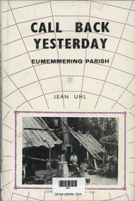
Book, Jean Uhl, Call Back Yesterday - Eumemmerring Parish, 1972
Eumemmerring covers a large area on the south-eastern (Dandenong) perimeter of Melbourne. Jean Uhl traces the development of this once peaceful district into a thriving, modern, industrial zone with its noise, its buildings and its land speculations. Through it we can follow the evolution of Australia from a primary producing company in the nineteenth century to a rapidly expanding industrial nation in the twentieth century. Personalities, buildings and landmarks are presented and discussed with loving care, thus making this book one of the most noteable local histories to be published in recent time in Victoria.xii, 109 p.; 24 cmnon-fictionEumemmerring covers a large area on the south-eastern (Dandenong) perimeter of Melbourne. Jean Uhl traces the development of this once peaceful district into a thriving, modern, industrial zone with its noise, its buildings and its land speculations. Through it we can follow the evolution of Australia from a primary producing company in the nineteenth century to a rapidly expanding industrial nation in the twentieth century. Personalities, buildings and landmarks are presented and discussed with loving care, thus making this book one of the most noteable local histories to be published in recent time in Victoria. eumemmerring (vic.), dandenong (vic.), dandenong (vic.) - history -
 Narre Warren and District Family History Group
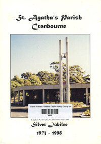
Book, St Agatha's Church (Cranbourne), St Agatha's Parish Cranbourne: Silver Jubilee 1973 - 1998
A book about the silver jubilee of St Agatha's Parish Cranbourne: 1973 - 1998non-fictionA book about the silver jubilee of St Agatha's Parish Cranbourne: 1973 - 1998cranbourne (vic.), st agatha's parish cranbourne -
 Ringwood and District Historical Society
Document - Map, Part of Crown Allotment 27C, Parish of Warrandyte, County of Evelyn, Ringwood, Victoria - c.1970
Photocopy of subdivision plan 75131 Vol 3439 Fol 712 showing numbered residential allotments with property dimensions.Surveyors and Consulting Engineers - O'Connor & Beveridge, Main Eltham Road, Lower Plenty, Tel. 432668. Rubber-stamped "Photocopy - Titles Office Complied 17 Feb 1970". Map includes Lockhart Road, Lansell Close, Terrara Place, Goldsmith Avenue, Park Hill Drive, Hilldale Close, and Elm Court, Ringwood, Victoria. -
 Ringwood and District Historical Society
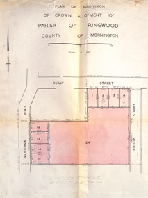
Document, Plan of Subdivision - Part of Crown Allotment 10A, Parish of Ringwood, County of Mornington - 1957
Map of residential allotments in Wantirna Road and Reilly Street, Ringwood, and Philip Street, Heathmont, Vic.Footnote includes "Lots numbered 5 to 11 and 16 to 23 both inclusive are not included in this plan. Signature of Consulting Engineer - Alan J. Brown BCE, LS, MVIS, Licensed Surveyor, Dillons Buildings, 1 Riversdale Road, Camberwell (Phone) WF3528 dated 1-4-1957. -
 Ringwood and District Historical Society
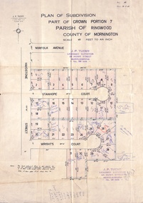
Document, Plan of Subdivision - Part of Crown Portion 7, Parish of Ringwood, County of Mornington - 1962
Map of residential allotments coloured red, with land coloured blue set apart for drainage & sewerage easements. Rubber stamped J.P. Tuohy, Licensed Surveyor, 25 Howe Street Murrumbeena, Tel. 561945, dated 38.8.1962.Map includes Maidstone Street, Norfolk Avenue, Stanhope Court and Wrights Court, Ringwood, Vic. Also includes handwritten Estate Agent sales notations. -
 Ringwood and District Historical Society
Document - Plan of Subdivision, Part of Crown Allotment 31B, Parish of Warrandyte - 1965
Map showing residential allotments numbered 1, 2, 4 and 5, on Through Road, Ringwood, Vic., with property dimensions, including weatherboard house and galvanised iron garage on lot 2.Kirkpatrick & Webber, Licensed Surveyors, Civil Engineers & Town Planners, Maroondah Highway, Ringwood, Telephone 8700321. Ref 3438C. Date 4th December, 1964. Amended 19th July, 1965. Notation: "The land coloured blue is a drainage and sewerage easement. Levels are to Board of Works Datum. Lot number 3 has been omitted." -
 Ringwood and District Historical Society
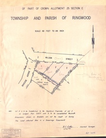
Document - Plan of Subdivision, Part of Crown Allotment 25 Section E, Township and Parish of Ringwood - 1961
Map showing residential allotments numbered 1, 2, 3 and 4, on Wilson Street and Braeside Avenue, Ringwood East, Victoria.Signed and dated 1/12/1961. Rubber stamped Kirkpatrick & Webber, Licensed Surveyors, Civil Engineers & Town Planners, 225 Maroondah Highway, Ringwood, Telephone 870-0321. Ref 3438C. "Note: Lot 4 is to be transferred to the Registered Proprietor of Lot 2 on Lodged Plan 23477 and is to be consolidated therewith." Map also includes handwritten Estate Agent notations. -
 Narre Warren and District Family History Group
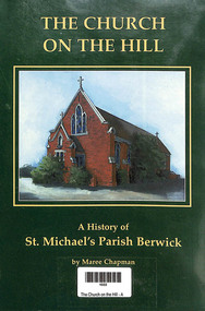
Book, Maree Chapman, The Church on the Hill - A history of St. Michael's Parish Berwick, 1996
The first church, built of weatherboard, was erected in 1870. It was originally part of the Brighton Parish. St. Michael's Parish was established in 1956, having previously been part of the parish of Dandenong. In 1956 it became part of the Diocese of Sale. The current Church was opened on 29 April 1984 and was blessed by the Bishop of Sale Eric D'Arcy. The Architect was Smith and Tracey and the builder was C.D. Mason Constructions.non-fictionThe first church, built of weatherboard, was erected in 1870. It was originally part of the Brighton Parish. St. Michael's Parish was established in 1956, having previously been part of the parish of Dandenong. In 1956 it became part of the Diocese of Sale. The current Church was opened on 29 April 1984 and was blessed by the Bishop of Sale Eric D'Arcy. The Architect was Smith and Tracey and the builder was C.D. Mason Constructions.st michael's parish berwick, berwick (vic.), st francis xavier college, father john gallagher -
 Narre Warren and District Family History Group
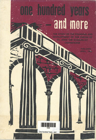
Book, James Lineham, One Hundred years and more - The story of the Founding and Development of the Parish of St. John The Evangelist Cranbourne, 1966
The history of the parish of St John The Evangelist in Cranbournenon-fictionThe history of the parish of St John The Evangelist in Cranbournest john the evangelist church, cranbourne (vic.) -
 Narre Warren and District Family History Group
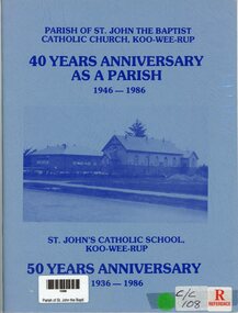
Book, 40 years Anniversary as a Parish - St Johns Catholic School Kooweerup - 50 years Anniversary, 1986
A book published for the 50th anniversary of St John's Catholic Church School in Koo Wee Rup and 40 year celebration of the Parish of St. John The Baptist Catholic Church Koo Wee Rup. Photos and names in booknon-fictionA book published for the 50th anniversary of St John's Catholic Church School in Koo Wee Rup and 40 year celebration of the Parish of St. John The Baptist Catholic Church Koo Wee Rup. Photos and names in bookkoo wee rup (vic.), st john the baptist church, st john's catholic church koo wee rup -
 Ringwood and District Historical Society
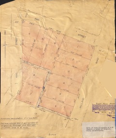
Document - Plan of Subdivision, Parts of Crown Allotments 45 & 46, Township & Parish of Ringwood, County of Mornington - 1950
Map on manila folder attached to cardboard backing showing residential allotments on King Street and Holland Road, Ringwood East.Signature of Russell Francis Kinnane, Licensed Surveyor, 4th December, 1950. -
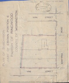 Ringwood and District Historical Society
Document - Plan of Subdivision, Part of Crown Portion 6 Parish of Ringwood, County of Mornington - (Undated, circa 1913)
Map attached to blue cardboard backing showing weatherboard house and 3 residential allotments on Wantirna Road between Kirk Street and Vine Street, Ringwood. -
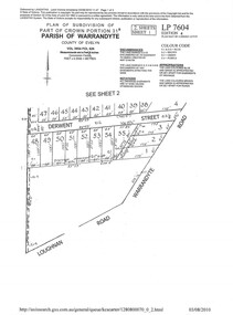 Ringwood and District Historical Society
Document - Subdivision Plan, LP7604 Part of Crown Portion 31B, Parish of Warrandyte, County of Evelyn, Vol 3954 Fol 626 - 2019
A4 LANDATA Land Victoria plan printout dated 2010Map includes Derwent Street and Warrandyte Road, Ringwood. Although marked See Sheet 2, no other page included with collection. -
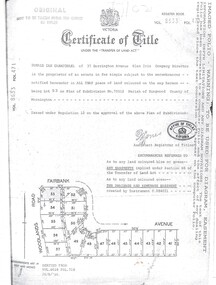 Ringwood and District Historical Society
Document, Certificate of Title Vol 8633 Fol 471, Plan of Subdivision No. 73512, Parish of Ringwood, County of Mornington
A4 Title Search Enquiry printout dated 2003, with Subdivision Map including Fairbank Avenue and Woodlands Road, Heathmont, Vic.Issued under Regulation 12 on the approval of the above Plan of Subdivision. Derived from Vol 8618 Fol 718, 26/8/1966. Proprietor - Donald Ian Carmichael of 37 Dorrington Avenue Glen Iris. -
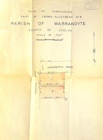 Ringwood and District Historical Society
Document - Plan of Subdivision, Part of Crown Allotment 31B, Parish of Warrandyte, County of Evelyn - (undated, circa 1960s)
Map showing residential allotments numbered 1 and 2 on Through Road and Unsworth Road, Ringwood, Vic., with property dimensions and location of drainage & sewerage easement.H.J. Macey Licensed Surveyor, 36 Nerissa Street, Burwood (Telephone) BX1917. -
 Ringwood and District Historical Society
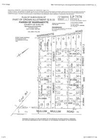
Document - Subdivision Plan, Part of Crown Allotment 32 & 33 Parish of Warrandyte, County of Evelyn Vol 3922 Fol 242
LANDATA Land Victoria 2-sheet plan printout dated 16/6/1919.Sheet 1 includes Warrandyte Road, Hobart Street, Paxton Street, and Mullum Mullum Road, Ringwood, Vic. Additional markings include PS327701, LP215189, RP7936, LP110103, LP36735, LP31149, SP24012, PS310739, PS326740, PS336885, LP41558. Sheet 2 includes Warrandyte Road, Paxton Street, Arnold Street, and Mullum Mullum Road, Ringwood, Vic. Additional markings include RO270, SP26622, LP50242, RP19467, SP27005, SP31440, PS312181. -
 Clunes Museum
Map, Township of Clunes - Parish of Clunes - County of Talbot
Map of Clunes Township in 19511 X PHOTOCOPY OF MAP, (COMPRISING A NUMBER OF A4 SHEETS TAPED TOGETHER) SHOWING LOT NUMBERS AND NAMES OF LANDHOLDER. REFERENCE GAZ 1951.1480. SCALE 30 CHAINS = 1 INCH 1 X PHOTOCOPY OF MAP, (COMPRISING A NUMBER OF A4 SHEETS TAPED TOGETHER) SHOWING LOT NUMBERS AND NAMES OF LANDHOLDER. REFERENCE: G76359 GENERAL FILE TOWNSHIP RESIDENTIAL ALLOTMENTS SCALE 30 CHAINS = 1 INCHNOTATED IN PURPLE CRAYON ON SECOND MAP: AS AT LATE 1984 COPY OF MAP FROM LAND TITLES OFFICE BALLARATtownship of clunes map, 1951 -
 Ringwood and District Historical Society
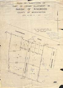
Map - Plan of Subdivision, Part of Crown Allotment 39, Parish of Ringwood, County of Mornington - (Undated - circa 1930s)
Copy of land title map on light cardboard backing showing layout and size of 11 allotments in Canterbury Road and Culverlands Road, Heathmont, Victoria. Hand-written sales notations on map and backing include names and telephone numbers - Mr Robinson MJ2411, Mr Smith MX5425, Abicare WY1848. Later notation 12/12/67 - A. Robertson. Rubber stamp imprint in top left corner - D.H. Oliver, Civil Engineer & Licensed Surveyor, Bellevue Street Lilydale, Phone Lilydale 91. -
Clunes Museum
Map, DEPARTMENT OF LANDS AND SURVEY, TOWNSHIP OF CLUNES, PARISH OF CLUNES, COUNTY OF TALBOT, 1950
MAP OF CLUNES ON PAPER SHOWING HOTELS AND TOWNSHIP HIGHLIGHTS COMPLETE WITH LEGEND. OVERWRITTEN NOTATIONS IN RED AND BLUE INKPRICE 2stownship of clunes 1950, hotels of clunes -
Stawell Historical Society Inc
Map, Department of Lands & Survey J. Noone, Township of Heatherlie. Parish of Baroka. County of Borung 1888, 1888
Stawell & Grampians Freestone Quarry Company Railway Reserve. Cross & masons Quarry Site. Mamnager'sHouse, Stead's boarding House Stawell and Grampians railwaySurveyed Township Showing Quarry and railway Reservephoto Lithographed at the Department of lands and Survey Melbourne By J Noone 15.6.88railway quarry -
Whitehorse Historical Society Inc.
Map, Directory Maps of the County of Bourke, 1892
Copies of Directory maps:(i) Title Page, (ii) Preface (iii) Heading section of Map of Melbourne and Suburbs (iv) Parish of Bulleen - includes 'North - East portion of the Parish of Nunawading (v) Village of Burwood. Note: 107(a), 107(b), 107(c) are copies of the same set of sheets.Copies of:(i) Title Page, (ii) Preface (iii) Heading section of Map of Melbourne and Suburbs (iv) Parish of Bulleen - includes 'North - East portion of the Parish of Nunawading (v) Village of Burwood. Note: 107(a), 107(b), 107(c) are copies of the same set of sheets.Copies of Directory maps:(i) Title Page, (ii) Preface (iii) Heading section of Map of Melbourne and Suburbs (iv) Parish of Bulleen - includes 'North - East portion of the Parish of Nunawading (v) Village of Burwood. Note: 107(a), 107(b), 107(c) are copies of the same set of sheets.maps, parish of bulleen, parish of nunawading, burwood -
 Linton and District Historical Society Inc
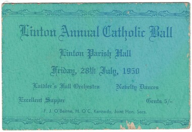
Ticket, Linton Annual Catholic Ball, 1950
Green cardboard ticket with blue printed text. Ticket is for a ball held at Linton Parish Hall, Friday, 28th July, 1950.Text: " Linton Annual Catholic Ball / Linton Parish Hall / Friday, 28th July, 1950 / Laidler's Full Orchestra Novelty Dances. "linton annual catholic ball, linton parish hall -
 Linton and District Historical Society Inc
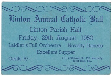
Ticket, Linton Annual Catholic Ball, 1952
Blue cardboard ticket with blue printed text. Ticket is for a ball held at Linton Parish Hall, Friday, 29th August, 1952.Text: " Linton Annual Catholic Ball / Linton Parish Hall / Friday, 29th August, 1952 / Laidler's Full Orchestra Novelty Dances. "linton annual catholic ball, linton parish hall -
Whitehorse Historical Society Inc.
Article, People's priest finds a new flock, 2001
Article on Father Frank Dillon.Article on Father Frank Dillon, parish priest of St John's Catholic Church, Mitcham, who is transferring to Geelong.Article on Father Frank Dillon.dillon, kevin joseph, fr, st johns catholic church, mitcham -
 Warrnambool and District Historical Society Inc.
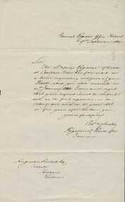
000851.1; Letter 000851.2:Copy of Baptismal entry, Augustus Bostock birth details, 000851.1. 1884. 000851.2 late 20th century
Augustus Bostock was the 9th child of Robert & Rachael Bostock of Vaucluse Epping Forest, Van Diemen’s Land. He was only 4 years old when his mother died. He was inspired by his father to seek his fortune in the Western District of Victoria. He arrived around 1850. He married Margaret Aitkin in July 1865. Augustus owned several properties in the district and leased others. He sat on the court of Warrnambool, Mortlake or Hexham as required. He resided at Marramook in Hawkesdale and later moved to Vaucluse in Hopetoun Road Warrnambool, where he died in 1920 at the age of 87. He was involved in many aspects of life in the Western District, racing, cricket, and social activities to name a few. These two documents relate to the registration of Augustus Bostock’s birth 14/01/1833. This is one of a number of documents which relate to the Bostock family who were one of the most important pioneering families of the Western District. They owned and leased various properties around Warrnambool and were involved in many aspects of social and business life. This is a personal document which confirms details of the birth of Augustus Bostock.000851.1. Handwritten letter from General Register Office Hobart. Foolscap sized lined white paper with writing in black ink. 000851.2 Copy of baptisms in the parish of Campbelltown 1835. Handwritten entries in chart form with handwritten entries. 000851.1 General Register Office Hobart. 000851.2 Parish of Campbelltown in the county of Cornwall 1835. warrnambool, augustus bostock, robert and rachael bostock, campbelltown, hobart 1835. -
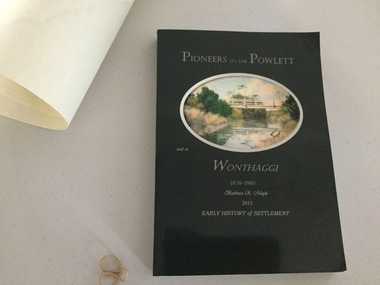 Wonthaggi & District Historical Society
Book and Map, Barbara Moyle, Pioneers on tthe Powlett and at Wonthaggi 1878-1910, 2015
Book - families social histories, maps, photograps Map - block numbers town names physical / geographical featuresFarming and social history of pioneers of the Powlett River are prior to the establishment of the State Coal Mine at Wonthaggi. Significant land marks, buildings and photographs are included. Dark green cover with oval artists impression of Powlett river and bridge Associated map which covers the parishes plus key places of interestlPioneers on the Powlett and at Wonthaggi 1878-1910 Barbara R Moyle 2015 Early History of Settlement Map - Parish names, significant sitesfarming, pioneers of wonthaggi and district, wonthaggi families