Showing 10939 items matching " plan"
-
 Federation University Historical Collection
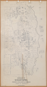
Plan, Borough of Sebastopol, 1940, 01/07/1940
Sebastopol became a suburb of the City of Ballarat.Plan showing the streets, allotments creeks in the Borough of Sebastopol, Parishes of Ballaarat and Cardigan, County of Grenville, in 1940. sebastopol, t. rider, yarrowee creek, leigh river, st george's reserve, leigh creek, sebastopol public gardens, sebastopol recreation reserve, gravel reserve, night soil depot, sanitary depot, rubbish depot -
 Flagstaff Hill Maritime Museum and Village
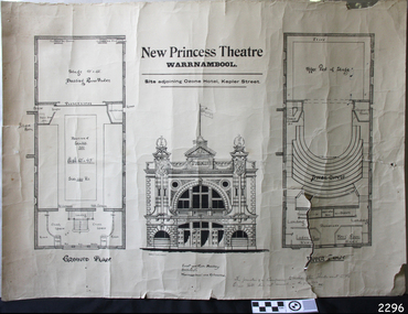
Plan
Plan Architects of the New Princess Theatre, Kepler Street, Warrnambool, also the prospectus of the Princess Theatre Company.flagstaff hill, warrnambool, shipwrecked-coast, flagstaff-hill, flagstaff-hill-maritime-museum, maritime-museum, shipwreck-coast, flagstaff-hill-maritime-village, princess theatre, kepler street, princess theatre company -
 Federation University Historical Collection
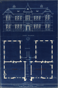
Plan, Ballarat School of Mines New Classroom, c1899, c1897
Blue plan of the front and ground electation of the Ballarat School of Mines Administratoin Building (later Administration Building).ballarat school of mines, new classrooms, administration building, buildings -
 Federation University Historical Collection
Plan, Shewing the workings of the Kuboid Quartz Gold Mining Company, Sulky Gully, not dated
Hand drawn plan with red and blue shading showing the workings of the Kuboid Quartz Gold Mining Cokuboid quartz gold mining company, gold mining, sulky gully -
 Federation University Historical Collection
Plan, Preliminary Measured Drawing of the Former Gaol Governors Residence Lydiard Street, 1977, 28/06/1977
Plans showing the ground floor and first floor of the Ballarat School of Mines former Gaol Residence building. former gaol governor's residence, ballarat school of mines, former ballarat gaol, architectural drawing -
 Ringwood and District Historical Society
Article - Newspaper Clipping, Land Sale Advertisements, Golden Hill Estate, Ringwood - 1965, 1966, and Plan of Survey of Lot 8, Mullum Mullum Road Ringwood, 1970
Newspaper clippings from Melbourne Sun newspaper (11th December 1965 and 15th January 1966) advertising sale of land - Golden Hill Estate, Ringwood, with summary of features and aerial photograph including artistic representation of street layout. Subdivision includes Mullum Mullum Road, Sonia Street, Jill Court, Linda Drive, Eve Court, Alma Court, and Jacynthe Court. Attachments include reference to Lot 46 as site of original Peter Vergers' orchard residence and subsequent 1970 surveyor's Plan of Survey of Lot 8 Mullum Mullum Road Ringwood, LP 67513, Cert of Title 8581/429.Agent - Aaron, King & Co., Suite 2, 33 Queens Road, Melbourne. (Phone) 26-2443, A.H. 850-2195. Plan of Survey signed on 25.7.1970 by Roger M. Gamble, Land Surveyor, 28 Summit Crescent, Ringwood 3134. -
 Wonga Park Community Cottage History Group
Plan (sub-item) - Plan re moving State School to corner of Yarra and Brysons Roads
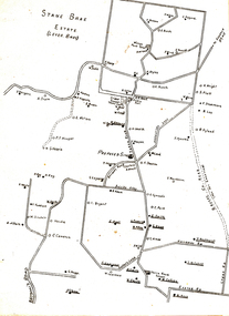
A plan prepared by Mr. A.J. Upton (secretary and convenor of the Wonga Park School Committee) in about 1920, when residents were pressing for a new school to be located at the junction of Bryson’s and Yarra Road, the object being to combine the Wonga Park and Yarra Road Schools. Although the proposal was eventually dropped, this plan shows who lived in Wonga Park in the 1920’s and where they lived. [It is likely that this plan dates from some time after 1920.]wonga park school -
Melbourne Tram Museum
Document, Smart Passengers Inc, "Transport Plan - An Alternative Option - 2010 - 2020 Plan", 2009
Document published by Smart Passengers c2010, titled "Transport Plan - An Alternative Option - 2010 - 2020 Plan" a response to the 2008 Victorian Transport Plan, looks at projects that could improve public transport - train, tram and bus for Melbourne. Has a Table of Contents. Includes comments on policies, Docklands tram depot, inner city trams, rail capacity upgrades, bus interchanges, 2020 Train timetable and Flinders St station platform issues. Includes a Glossary of terms. Signed by Michael Angelico as President. The organisation website is no longer active.Demonstrates a privately produced planning document for Melbourne's public transport.Document - book - 32 A4 pages, centre stapled, full colour. Has an A5 errata.trams, tramways, melbourne, public transport, tram, rail, buses, smart passengers -
 Flagstaff Hill Maritime Museum and Village
Plan - Lines Plan, S.S. Rowitta, ca 1909
The lines plan was drawn for the building of the steamship S.S. Rowitta, a passenger steam ferry built in Hobart for use in Tasmania's rivers, the Derwent and the Tamar. It is a copy of the original lines plan. The S.S. Rowitta was built by Purdon & Featherstone, at Battery Point, Hobart (Tasmania) in 1909 from Huon Pine and Kauri planking. Her final configuration included three masts and a ship rig. S.S. Rowitta took its first voyage from Hobart to Launceston in 1909 and operated for 30 years as a passenger ferry on the Tamar and Derwent Rivers. She also served as a freighter, an army supply ship, a luxury charter ferry and a floating restaurant as well as a prawn boat at Lakes Entrance. (She has also been named “Sorrento” and “Tarkarri”.). In the very early days of Flagstaff Hill ‘Rowitta’ was purchased from Lakes Entrance by Warrnambool City Council and the Victorian State Government for $20,000. The Rowitta had a hull configuration very similar to a local boat named the SPECULANT, which played a key role in the Port of Warrnambool in the early 1900s. The Speculant was the largest ship ever registered with Warrnambool as her home port. Local owner and trader P J McGennan & Co, (Peter McGennan) used her as a freight carrier to Melbourne and timber trader between New Zealand and Victoria. She sunk at Cape Otway in 1911 on a voyage to Melbourne. In 1974 Rowitta was delivered to Port Fairy and then later sailed to Warrnambool’s Breakwater where she was lifted out of Lady Bay and loaded onto the back of a long transport truck and slowly and carefully driven along Pertobe Road, through the Surfside Caravan Park and over the railway line, into Flagstaff Hill’s Maritime Village. Transfer arrangements were coordinated by Jack Morse, of Morse Engineering, a member of the Flagstaff Hill Planning Board, and Ken Goyen, a local crane operator. The ‘Rowitta’ was originally acquired to be rebuilt to match the original SPECULANT. When finances became tight in 1976 a review of all plans ended in the decision to restore the “Rowitta” to her original configuration. She was then restored, renamed the original name of “Rowitta” and installed in the Village’s Harbour Lake to become one of the popular vessels on display for visitors to enjoy. It was the decision of the Advisory Committee to Flagstaff Hill to have Rowitta demolished in April 2015 due to extensive deterioration. Items associated with the Rowitta continue to be held in Flagstaff Hill Maritime Village’s Collection.The lines plan of the passenger ferry S.S. Rowitta.is significant for its association with Tasmanian history from the early to mid-1900s. It is also connected to the history of the Rowitta, which was a large exhibit on display at Flagstaff Hill Maritime Village from the museum’s early beginnings until the vessel’s end of life 40 years later. The Rowitta represents the importance of coastal traders to transport, trade and communication along the coast of Victoria, between states, and in Australia before rail and motor vehicles. The vessel was an example of a ferry built in the early 20th century that served many different roles over its lifetime of over 100 years. Lines Plan, copy, of the steamship S.S. Rowitta. Rectangular drawing paper with copy of the hand drawn lines plan showing several profiles of the vessel. The vessel was built in 1909 by Purdon & Featherstone, Hobart. On the revers is handwritten inscription, and a white label with a handwritten number.Printed on the plan: "S.S. ROWITTA / LINES PLAN / SCALE 1/4" TO 12" " Blue ink writing on the back: "Rowitta" Blue ink on label: "56"flagstaff hill, warrnambool, shipwrecked-coast, flagstaff-hill, flagstaff-hill-maritime-museum, maritime-museum, shipwreck-coast, flagstaff-hill-maritime-village, photograph, s.s. rowitta, charles street wharf,, launceston., purdon & featherstone, rowitta, tarkarri, speculant, purdon & featherstone of hobart, passenger ferry 1909, sorrento, lines drawing, ship's plan, lines plan, line plan, shipbuilding, ferry -
![Map, Plan of Town Allotments Bacchus Marsh [1873]](/media/collectors/5e461d8021ea67224c82f2a1/items/677a8ee7ab7bb47995c5573f/item-media/677a8fdeab7bb47995c55b56/item-fit-380x285.jpg) Bacchus Marsh & District Historical Society
Bacchus Marsh & District Historical SocietyMap, Plan of Town Allotments Bacchus Marsh [1873]
James Young was a prominent businessman, land owner and public figure in the early colonial period of Bacchus Marsh. After his death in 1871 land remaining from his estate in Bacchus Marsh was sold at auction in 1873. The sale of his estate included the substantial stone residence in Bennett Street which later became known as 'Stone Villa'. The sale of his land in 1873 was conducted by local auctioneer James Crook. 29 allotments were advertised for sale, although the plan for the sale indicated 30 allotments. The sale notice in the Bacchus Marsh Express of 11 October 1873 noted that the allotments were " in the very centre and heart of the most populous and business portion of the township, at the same time being the only remaining portion of the business block available for purchase by public sale, which fact intending purchasers should not lose sight of, as the opportunity cannot occur again". The designation of a new street, 'Bennett Street', shown on the plan, is also indicated in the advertising, "In reference to the main street frontages, opposite the Border Flour Mills. The Auctioneer would also direct attention to the plan, showing the formation of a new thorough fare (Bennett street) leading from Young street into Gell street, thus opening up the township on the high, more healthy, and commanding position so much to be desired for private dwellings".An important cartographic document which indicates an early major subdivision of land in the inner urban area of the Bacchus Marsh township. This subdivision lead to the continuing residential and commercial development of the township of Bacchus Marsh in the later part of the 19th century. The location of two well known demolished public structures, the Free Gardeners Hall in Gell Street, and the Old Mechanics Institute Hall (aka the Buffs Hall), on the corner of Young and Bennett Streets, are also shown on this map.A single page paper map showing 30 blocks of land for sale around 1873 in the vicinity of Bennett Street and Lerderderg Street. Described in contemorary sources as a 'lithographed copy'. No scale is indicated. The map is pasted into a bound volume containing 76 maps or plans in total. High resolution digital image stored on BMDHS computer network. land sales bacchus marsh, bacchus marsh victoria maps, james young 1816-1871, bacchus marsh roads and streets, bennett street bacchus marsh -
Linton and District Historical Society Inc
Floor plan, Floor plan of Railway Hotel, Linton, 1953
Architectural drawing showing block and floor plan of Linton's Railway Hotel. The plan appears to have been drawn up for the Ballarat Brewing Company, which owned the hotel, in connection with proposed renovations. Plan is initialled "J. O. O'B." and dated"5.5.53". Plan shows bar area, parlours and dining rooms, residential areas, ablutions areas, staff bedrooms, rooms used for accommodation, and outbuildings (stable, garage etc.).railway hotel linton, maps and plans, floor plans -
![Map, Plan showing proposed deviation of the road through McKenzie's Flat to Bacchus Marsh. [Undated]](/media/collectors/5e461d8021ea67224c82f2a1/items/677d22f37f2053f3e5d500dc/item-media/677d25247f2053f3e5d50950/item-fit-380x285.jpg) Bacchus Marsh & District Historical Society
Bacchus Marsh & District Historical SocietyMap, Plan showing proposed deviation of the road through McKenzie's Flat to Bacchus Marsh. [Undated]
The date of this map or plan is uncertain. McKenzie's Flat is a bushland picnic area on the Lerderderg River in the Lerderderg State Park close to Bacchus Marsh. The proposed road deviation shown on this map is very close to a sharp bend in the Lerderderg River which shows an island in the centre of that bend. The name of a landholder, J.B. Perry is shown on the map close to the area of the road deviation.The land shown is identified as within the Parish of Merrimu.Single page map showing a proposed deviation of the road from McKenzie's Flat to Bacchus Marsh. Scale: 5 chains to 1 inch. Part of a set of maps which are pasted into a bound volume containing 76 maps or plans in total. High resolution digital image stored on BMDHS computer network. mckenzies flat bacchus marsh, bacchus marsh roads and streets -
Port Melbourne Historical & Preservation Society
Plan - Multi-unit development, 164 Ingles Street, Port Melbourne, Site Plan 164 Ingles Street, 2015
Site plan for multi unit development. 164 Ingles St, Port Melbourne 2015-2016 A3 sheet black and white printing On the site of Symex, J KItchen &Sons factory sitebuilt environment - domestic, woodruff street development pty ltd, canny building pty ltd, j kitchen & sons pty ltd, symex holdings ltd -
 University of Melbourne, Burnley Campus Archives
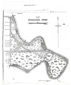
Plan - Photocopy, A.L. Martin et al, Plan of Richmond Park, 1872
Layout of Richmond Park showing railway line, Pic-Nic Station, Swan Street extension and Horticultural Society's Garden. 3 photocopies of plan surveyed and drawn by A.L. Martin, Authorised Surveyor. Photolithographed at Dept of Lands and Survey by J. Noone 6th Sept. 1872. Showing the entire park and the Horticultural Society's Garden.richmond, parks, a.l. martin -
 Federation University Historical Collection
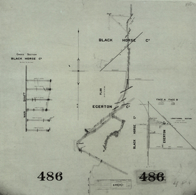
Plan, Black Horse Co
Plan showing a plan and cross section of the Black Horse Co. It also shows the Egerton Co, black horse co, cgt, mining, geological survey, cross section, egerton co -
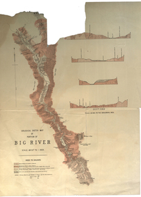 Federation University Historical Collection
Plan, Geological Sketch Map of Portion of Big River
Printed map on paperscale, index to colours, sectionsgeological sketch map, plan, big river, mount wills, geology -
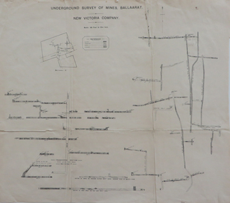 Federation University Historical Collection
Plan, Underground Survey of Mines Ballaarat, New Victoria Company, not dated
Printed transverse section of the New Victoria Company.underground survey, new victoria company, transverse section, mining, plan -
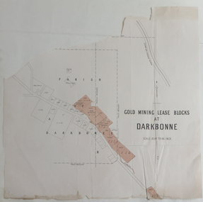 Federation University Historical Collection
Plan, Goldmining Lease Blocks at Darkbonne, c1887
This map was originally inserteed into the Reports of Mining Registrars for the Quarter ender 30th June 1887.Paper plan showing Goldmining Lease Blocks at Darkbonne, north west of and near St Arnaud, on the Sunraysia Highway. darkbonne, st arnaud, new bendigo mine, alpha mine, working miners mine, chinese camp, donald/st arnaud railway, saint arnaud, darkbonne state school -
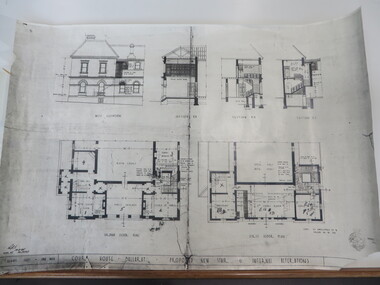 Federation University Historical Collection
Plan, Court House Ballarat Proposed New Stair & Internal Alterations, 1935, 10/05/1935
Photocopy of a plan of the former Ballarat Supreme Court House showing ground floor, first floor and three sections. former ballarat supreme court house, ballarat school of mines, architectural plans -
Clunes Museum
Plan, CLUNES WATER SUPPLY
DRAWINGS MADE TO SET UP A PERMENT PIPED WATER SUPPLY TO NEW NORTH MINE, CLUNES, VICTORIA, AUSTRALIA1 PAGE PLAN WITH DRAWING OF CLUNES WATER SUPPLY ON WAXED PAPER USING RED, BLACK AND BLUE INKCLUNES WATER SUPPLY LONGITUDINAL SECTION OF CENTRE LINE OF THE LOWER AWUEDECT FROM WEIR A TO SERVICE RESERVOIR DRAWING 420 5 CONTRACT NO. 740 2 HORIZONTAL SCALE FOUR CHAINS TO AN INCH VERTICAL SCALE FORTY FEED TO AN INCH SIGNED BY OCTAVIUS LANGTREE WORKS ENGINEER 13/12/1870octavius langtree, peter lalor, clunes water supply -
 Federation University Historical Collection
Booklet, University of Ballarat 2009 Draft Strategic Plan Proposals and 2008 Progress Report, 2008, 2008
University of Ballarat later became Federation University Australia. Draft document outlining proposals for the 2009 University Strategic Plan.university of ballarat, strategic plan, vision, dare to be different, motto, charter, david battersby -
University of Melbourne, Burnley Campus Archives
Document - Photocopy, James Hitchmough, VCAH Burnley Field Station Draft Development-Management Plan, 1991
Draft by James Hitchmough: Recommendations, discussions, hand-drawn planvcah, burnley, filed station, james hitchmough -
Whitehorse Historical Society Inc.
Document, Box Hill Gardens Master Plan, 2011
City of Whitehorse plans for Box Hill Gardens, Feb 2011.City of Whitehorse plans for Box Hill Gardens, Feb 2011.City of Whitehorse plans for Box Hill Gardens, Feb 2011.box hill gardens, plans -
 Whitehorse Historical Society Inc.
Article, North East Link Plan, 2018
Plans for the North East Link project can be viewed at northeastlink.vic.gov.auPlans for the North East Link project can be viewed at northeastlink.vic.gov.auPlans for the North East Link project can be viewed at northeastlink.vic.gov.aunorth east link, eastern freeway, bicycle paths -
Stawell Historical Society Inc
Map, Plan Shewing Auriferous Deposits and Reefs (Map of Water Races), c1878
Plan Shewing Auriferous Deposits and Reefs (Map of Water Races)stawell, water -
Stawell Historical Society Inc
Map, Plan of Apsley Co. Prospectus Apsley Gold Mining Company, 1895
Plan of Apsley Co. Prospectus Apsley Gold Mining Companystawell -
Stawell Historical Society Inc
Map - Plan, Earle and Partners, Restoration of Pleasant Creek Courthouse Stawell West 1975, 4/8/1975
Designs for Restoration. Includes details for Public Toilet & Trees.A1 Plan of PrecinctDrawing No. 5 4.8.1975. Pleasant Creek Court of Petty Sessions Built in 1860. Museumstawell historical -
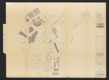 University of Melbourne, Burnley Campus Archives
Plan, Burnley Horticultural College: Site Plan, 1983-1984
Plans of the Burnley Campus, Ornamental Gardens from Plan 11.0715 by Alexander Metherell Pty. Ltd. Dated November 1983. Scale 1:500. (1) 5 copies, buildings shaded showing construction type. Job No BHC/1 Drawing No SP/1. Tree placements stamped on, includes legend. (2) 2 copies No SP/1c. In Description column, "A" Building Names 7/02/1984. Also see B15.0352 full report. B11.0715 originals. B11.0599 SP/3.ornamental gardens, burnley campus, burnley horticultural college, alexander metherell p/l -
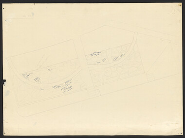 University of Melbourne, Burnley Campus Archives
Plan, Plan Survey Perennial Border and environs and Spring Display, 1982-1990
(1) Tracing paper plan of bed. (2) Perennial Border Spring Display Planted 1982, plantings numbered but no names. (3) Pencil on paper, names of plants, some in pen. Area now known as the Grey Garden. Old Storage Shed cleared in 1979. (4) Tracing paper copy, VCAH Burnley Plan Survey: Perennial Border and Environs, dated 8.11.90. Scale 1:100. This might be where the Herbaceous Border is in 2012. (Also see 11.0615).gardens, vcah burnley, perennial border, spring flowers -
 Ringwood and District Historical Society
Manual, Southwood Primary School, Ringwood - Counter Disaster Plan Manual (undated - circa - post 1983) (Later version than 11626)
Bound Manual describing evacuation and emergency procedures. Includes Action Plan, Staff members, Instructions, Types of Threats and school building plan. Similar content (but later version) to VC 11626