Showing 2158 items
matching reef
-
 Bendigo Historical Society Inc.
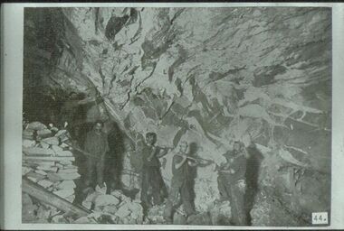
Slide - ALBERT RICHARDSON COLLECTION: BORING ON A REEF
Slide. Bendigo Mines-Jack Hattam Collection. Workers boring on a reef, underground at Catherine United Mine but could be New Moon. Image sourced from ' Healthy Golden Bendigo' book.No. 44 printed on bottom of slidemine, gold, catherine united, underground., bendigo mines-jack hattam collection. -
 Bendigo Historical Society Inc.
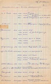
Document - MCCOLL, RANKIN AND STANISTREET COLLECTION: NAPOLEON REEF, 13th October, 1954
Four red and blue lined cashbook pages, Foolscap size, referring to the Napoleon Reef Gold Mining Company NL for uncollected 1st and final distribution of 7½ d. per share.gold, mining, share distritution, bendigo, gold mining, napoleon reef gold mining company. -
 Bendigo Historical Society Inc.
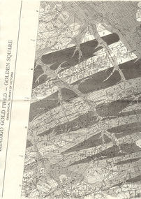
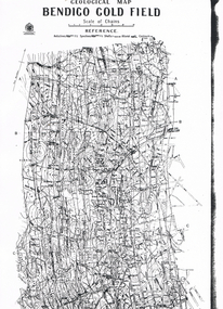
Map - LONG GULLY HISTORY GROUP COLLECTION: BENDIGO GOLD FIELD - GOLDEN SQUARE GEOLOGICAL SURVEY OF VICTORIA
BHS CollectionPart of a map of the Bendigo Gold Field - Golden Square. Geological Survey of Victoria. Shown are reefs, faults and anticlines. Many of the mines are shown on the map. Gullies, hills and streets are also shown.bendigo, history, long gully history group, the long gully history group - bendigo gold field - golden square geological survey of victoria, north bendigo state school reserve, hospital reserve, benevolent asylum reserve, empire hill, richmond hill, raes hill, south end hill, victoria hill, new chum hill, iron bark hill, redan hill, view hill, hustlers hill, camp hill -
 Bendigo Historical Society Inc.
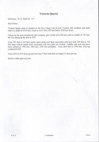
Document - VICTORIA QUARTZ - BRIEF NOTES ON THE VICTORIA QUARTZ MINE
Handwritten notes on the Victoria Quartz Mine. Notes mention locality, depth, geological information, Dividends, Calls and the Victoria Reef Tribute. Document from Albert Richardson Collection of mining history.document, gold, victoria quartz, victoria quartz, brief notes on the victoria quartz mine, victoria reef quartz shaft no 127, vict reef q m coy, mines dept, bendigo advertiser, victoria reef tribute -
 Bendigo Historical Society Inc.
Document - VICTORIA QUARTZ - NOTES ON THE VICTORIA QUARTZ 1910
Handwritten notes on the Victoria Reef Quartz Half Yearly Meeting, Cost of Shaft Sinking and striking water at the Victoria Quartz Mine. Includes detailed expenditure of wages, Firewood, explosives, etc.document, gold, victoria quartz, victoria quartz, notes on the victoria quartz 1910, victoria reef quartz, j h craig, h harkness & co, bendigo advertiser 1/2/1910 - 2/2/1910 - 30/6/1910, mr h mcgowan -
 Bendigo Historical Society Inc.
Document - MARKS COLLECTION: PLAN OF CHIMNEY STACK
Unlabeled plan, drawing shows side view of chimney stack, '5 feet' written on base of chimney. Plan could be associated with a mine on New Chum Reef Line, Victoria Hill.bendigo, mining, chimney side section, chimney stack -
 Bendigo Historical Society Inc.
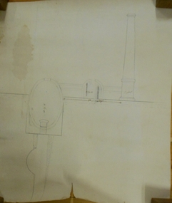
Map - RED WHITE AND BLUE EXTENDED MINE, 5/12/1940
Map: Transverse section of The Red, White and Blue Extended Mine, Sheepshead line of Reef, Bendigo. (9 Copies). By J.J. Caldwell, District Field Geologist, Mines Department Bendigo 5.12.1940map, bendigo, mining plan, red white and blue extended mine, sheepshead line of reef, mining , gold mines, j.j. caldwell -
 Bendigo Historical Society Inc.
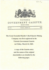
Document - GREAT EXTENDED HUSTLERS: GAZETTE ENTRY OF NAMES OF ORIGINAL SHAREHOLDERS
Display copy (3 pages) of the names of the original shareholders in the Great Extended Hustlers Reef Quartz Mining Co., first registered in the Victoria Government Gazette on Friday March 24, 1865.bendigo, mining, great extended hustlers -
 Bendigo Historical Society Inc.
Document - MINING REPORTS - THE MINING RECORD JAN., 1862
Photocopy of a printed 'The Mining Record' Jan., 1862 Pages 5 to 11. There is information on the Paddy's Gully Reef and the Sheep's Head Reef. The owners, area and title, workings, reef and yield, cost of working, drainage, machinery and remarks of the The Comet Company (formerly Cooper's Little Redan), Hogg, Tipper, & Milroy's Claim, Alliance Company, Watson & Wade's Claim, Barker & Co's Claim, Union Company's Claim, Paddy's Gully Reef Quartz Mining and Drainage Company's Claim, Picken and Co's Claim, Holmes and Co's Claim, Keith and Co's Claim, Stevens, Hasker & Co's Claim, Blewitt & Co's Claim, Thomson & Co's Claim, Hooper, Wills and Co's Claim, Union Company's North, or Lower, Claim, Sinclair and Co's Claim, Fogarty and Williams' Claim, Red, White and Blue Company's Claim, Union Company's Lower Whim Claim, Thompson's Claim, Union Company's Little Engine Claim, Will's Claim and the Union Company's South Claim. Albert Richardson Collectiondocument, gold, mining reports, mining reports, the mining record jan., 1862, the comet company (formerly cooper's little redan), hogg, tipper, & milroy's claim, alliance company, watson & wade's claim, barker & co's claim, union company's claim, paddy's gully reef quartz mining and drainage company's claim, picken and co's claim, holmes and co's claim, keith and co's claim, stevens, hasker & co's claim, blewitt & co's claim, thomson & co's claim, hooper, wills and co's claim, union company's north, or lower, claim, sinclair and co's claim, fogarty and williams' claim, red, white and blue company's claim, union company's lower whim claim, thompson's claim, union company's little engine claim, will's claim, union company's south claim, john s mcnair, john mathieson, mr lomasney, mr kelly, mr clisshold, j b watson & co, milroy & price, hogg, tiper, millroy, mr ebden, mrssrs watson and wade, r o smith, edward hunt, h murdoch, samuel priestly, william goldsmith, david buchanan, robert anderson, bagshot company, barker, ladams, m'vey, claughton, gutteridge, good, cornell, simeon, rutherford, h jackson, murgatroyd, wormold, bashford, red white & blue claim, steven's and hasker's, blewitt and co, john blewitt, richard allingham, edward wills, john williams, richard williams, henry williams, joseph east, john thomson, thomas trownson, henry hooper, edward wills, thomas castelow, joseph castlow, william tongue, george nevinson, james griston, thomas porter, william a kenny, robert lisle, john sinclair, robert pritchard, william pritchard, thomas woods, james fogarty, daniel moon, william lindrea, john adams, brown, robert lisle, owen thompson, nicholson reef company, edward wills, p n russell & co, bendigo valley steam puddling company, metropolitan mills, bruce's, thos. woods -
 Bendigo Historical Society Inc.
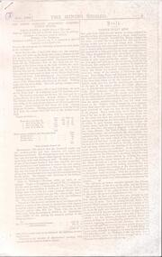
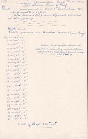
Document - GARDEN GULLY LINE OF REEF STATISTICS
Handwritten notes of statistics on the Garden Gully Line of Reef. Notes mention name of mine, years, tons of ore, yield (ozs and dwts), Calls and Dividends. Some also have the mine number, others have the Sheet No. Mines mentioned are: New Moon, North New Moon, Suffolk United, North Argus, Clarence, New Argus 202, Specimen Hill United, Virginia and Specimen Hill, Virginia, Great Northern, McDuff, McBeth, constellation, Golden Pyke, Johnson's Reef Extended, Golden Age, Princess Dagmar, South New Moon, Gt South New Moon, Johnsons Reef, North Johnsons, Confidence Extended and Windmill Hill. Document from Albert Richardson Collection of mining history.document, gold, garden gully line of reef statistic, garden gully line statistics, new moon, north new moon, suffolk united, north argus, clarence, new argus 202, specimen hill united, virginia and specimen hill, virginia, great northern, mcduff, mcbeth, constellation, golden pyke, johnson's reef extended, golden age, princess dagmar, south new moon, gt south new moon, johnsons reef, north johnsons, confidence extended, windmill hill, m d, 3 a m s 1/6/99, 3 d e t a o d 1952, garden gully line of reef -
 Bendigo Historical Society Inc.
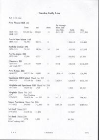
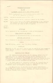
Document - Regulation of Mines Bill, famous mines of Bendigo, April, 2014
Seven men were killed at the Great Extended Hustler's mine disaster on 2nd May 1914 by an explosion of dynamite occurring as the men were waiting at the plat to ascend the mine at the end of their shift. No blame was attached to anyone in the findings of the inquisition. It was unknown what caused the dynamite to explode. Three page typed document. First page: 'The Regulation of Mines Bill' by Albert Richardson; Angus Mackay, Minister of Mines introduced the Bill in the Legislative Assembly on October 16th 1873 and it became law on January 1st 1874. Second page: 'Famous Gold Mines of Bendigo and Eaglehawk' by Albert Richardson, discusses deep shafts, more than 4000 feet shafts, wages for 1911. Hustler's Line of Reef mines are listed from north to south: Hustler Consols; United Hustler's and Redan, K.K., Comet, Hustler's Reef No. 1, Hustlers Reef, Great Extended Hustlers (formed 4.2.1865) Hustler's Royal Reserve Co., (Park Shaft) Hustler's Royal Reserve (City Shaft) and Fortuna Hustler's (formed August 1888).great extended hustlers, goldmining, accident, quartz, mining, k.k. mine, comet mine, hustler's line of reef, old comet, united hustler's, redan -
 Bendigo Historical Society Inc.
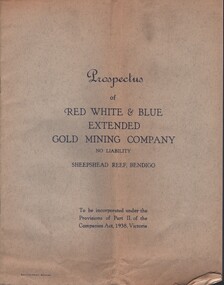
Document - MCCOLL, RANKIN AND STANISTREET COLLECTION: RED WHITE AND BLUE EXTENDED GM - PROSPECTUS, 1940
Documents: prospectus - 8 page booklet, inside back cover attached diagram - longitudinal section Sheepshead Line of Reefs - Bendigo , Locality plan shows Nell Gwynne Line, New Chum Line, sheepshead line, Deborah line, transverse section for Sheepshead line. Prospectus of Red White and Blue Extended Gold Mining Company No Liability Sheepshead Reef, Bendigo to be incorporated under the provisions of part 2 of the companies Act 1938, Victoria.MCCOLL RANKIN STANISTREETorganization, business, gold mining - legal, mccoll rankin stanistreet, red white and blue extrended gold mining company, nell gwynne line, new chum line, sheepshead line, deborah line. -
 Bendigo Historical Society Inc.
Document - MCCOLL, RANKIN AND STANISTREET COLLECTION: JERSEY REEF GOLD MINING CO, 1935
Copy of as 4 page typewritten prospectus of the Datmouth (Jersey Reef) Gold Mining Company. The company is being formed for the purpose of acquiring from the vendor his interest in Gold Mining Lease No. 6449, having an area of 45 acres 2 roods 28 perches situated at Inglewood in the parishes of Glenalbyn and Inglewood, Mining District of Maryborough. The area embraces the Jersey Line of Reef and has a length along same of approximately 680 yards. Dated 1935.gold mining, miners' safety cage, gold mining, dartmouth, jersey reef, inglewood, glenalbyn -
 Bendigo Historical Society Inc.
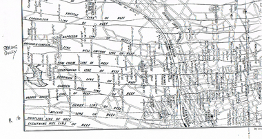
Map - LONG GULLY HISTORY GROUP COLLECTION: MAP OF REEFS AND MINES
BHS CollectionTwo pages with lines of reef and mines from Spring Gully Reservoir to north of the Eaglehawk Railway Station. Shown on the map are the lines of reef, the Thistle, Carshalton, Napoleon, British & Foreign, Nell Gwynne, New Chum, Sheepshead, Deborah, Garden Gully, Paddy's Gully, Derby, Miller's, Hustlers, Lightning Hill, Myers Flat, Lancashire, Cook's, Maiden Gully, Johnson's and Millers. Also shown are the Golden Square, Bendigo and Eaglehawk Railway Stations as well as the hills.bendigo, history, long gully history group, the long gully history group - map of reefs and mines, spring gully reservoir, thistle, carshalton, napoleon, british & foreign, nell gwynne, new chum, sheepshead, deborah, garden gully, paddy's gully, derby, miller's, hustlers, lightning hill, myers flat, lancashire, cook's, maiden gully, johnson's, millers, golden square railway station, bendigo railway station, eaglehawk railway station -
 Bendigo Historical Society Inc.
Document - PRINCESS ALEXANDRA COY & TRIBUTORS - NOTES ON PRINCESS ALEXANDRA COY & TRIBUTORS
Handwritten notes on the Princess Alexandra Coy & Tributors on the New Chum Line of Reef. Same ground as United Devonshire. This shaft sunk to 2285 feet. Also Saxon 7 Celt and Hopewell operated on this ground. List and depthof plats cut. Plats same as United Devonshire Coy. Sill of shaft 810.42 ft. On the back: Caleb Thomas - New Chum Line of Reef Sheet No VI Plan 4/12/1885. Notes prepared by Albert Richardson.document, gold, princess alexandra coy & tributors, princess alexandra coy & tributors, notes on the princess alexandra coy & tributors, united devonshire, saxon & celt, hopewell, caleb thomas, new chum line of reef sheet no vi plan 4/12/1885 -
 Stawell Historical Society Inc
Map - Picture, Plan of Mining Leaseholders and of Land Applies for under Mining Lease November 1887. Plus photocopy, 1887
Lists Businesses in Stawell Trade Directory Mines Listed. New Darlington Mine, Moonlight Junction, Magdala Extended, Moonlight Consols, North Magdala Moonlight, Magdala No 1,Pioneer & Galatea, Pleasant Creek Cross Reef, Moonlight, Moonlight Extended, Oriental, Cross Reef Consolidated, Sloanes and Scotchmans, Scotchmans United, Scotchmans & Cross Reefs,, New Perthshire, Federal, Wimmera Wonga And Birmingham, Rutlands, Wonga ExtendedFramed Stawell Trade Directory 1887 and Plan of Mining Leaseholders and of Land Applies for under Mining Lease November 1887. Plus photocopy.W C Bates Mining Surveyor 4.11.87stawell -
 Flagstaff Hill Maritime Museum and Village
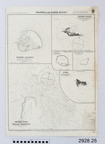
Document - Navigation Chart, Islands in the North Pacific (Western Hawaiian Group)
British Admiralty Navigation Chart - Islands in the North Pacific (Western Hawaiian Group) : Midway Islands, Seward Road and Welles Harbour, Necker Island, Cure or Ocean Island, Pearl and Hermes Reefwarrnambool, shipwrecked-coast, flagstaff-hill, flagstaff-hill-maritime-museum, maritime-museum, shipwreck-coast, flagstaff-hill-maritime-village, shipwrecked-artefact, navigation chart, british admiralty navigation chart, midway islands, islands in the north pacific (western hawaiian group), seward road, welles harbour, necker island, cure or ocean island, pearl and hermes reef -
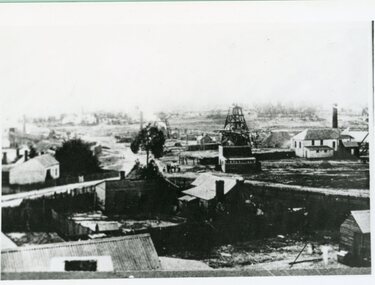
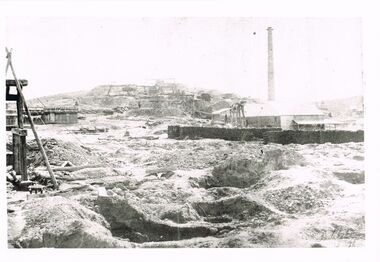 Bendigo Historical Society Inc.
Photograph - WES HARRY COLLECTION: MINING LANDSCAPE BENDIGO
Black and white photo copy: image shows heavily mined landscape, buildings (stone ? ) on RH side, brick chimney behind, line of whims heading to hill top along reef line.Batchelderplace, bendigo, mining landscape, bendigo, sandhurst, goldmining, gold -
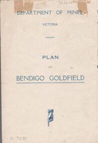 Bendigo Historical Society Inc.
Map - BENDIGO GOLDFIELDS MAP
Map of the Bendigo Goldfield, showing reef lines, mines and significant geographical features such as Monument Hill, Quartz Hill and Diamond Hill. On the back of map 'Department of Mines, Victoria. Plan of Bendigo Goldfield.bendigo, mining, bendigo goldfields -
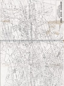 Bendigo Historical Society Inc.
Map - MAP OF BENDIGO GOLDFIELDS
Map. Copy of a map of the Bendigo Goldfields issued by the Dept. of Mines showing lines of reef, mines and streets. Scale 20 chains to 1 inch. Printed by Cambridge Press, Bendigo. Date unknownmap, bendigo, goldfields, map, goldfields, department of mines -
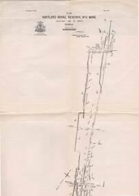 Bendigo Historical Society Inc.
Map - STRUGNELL COLLECTION: HUSTLER'S LINE OF REEFS, BENDIGO, September 1913
Map, Hustler's Line of Reefs, Hustler's Royal Reserve No.2 Mine, Bendigo Plan. Plate No.V1 (6). Bulletin No 33 Signed H.A.Whitelaw Underground survey Office Bendigo September 1913Underground Survey Office, Bendigo.map, bendigo, hustler's royal reserve no. 2 mine* -
 Bendigo Historical Society Inc.
Map - LONG GULLY HISTORY GROUP COLLECTION: GEOLOGICAL MAP - BENDIGO GOLD FIELD
Copy of a Geological Map of the Bendigo Gold Field. Map shows Lines of Reef, Anticlines, Synclines, Shafts, Alluvial Contours Gullies and some street names. Copy is hard to read. There are two pages.bendigo, history, long gully history group, the long gully history group - geological map - bendigo gold field, mines department, h herman, lightning hill line, hustlers line, derby line, paddy's gully line, garden gully line, deborah line, sheepshead line, new chum line, nell gwynne line, british and foreign line, napoleon line, carshalton line, thistle line, christmas line, lancashire line -
 Anglesea and District Historical Society
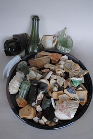
Glass and pottery fragments from the wreck of The Inverlochy, Estimated late 19th century
Assorted glass and pottery fragments collected over several years in the 1980s by local divers, Eric and Marianne Messer, diving on Ingoldsby Reef near the site where the "Inverlochy" was wrecked in December 1902.inverlochy, shipwrecks, ingoldsby reef -
 Phillip Island and District Historical Society Inc.
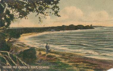
Photograph - Post Card, Early 1900's
One of 17 photographs donated by Olive BlameyColour postcard of shoreline with man and dog in foreground."Scene McCaffey's Reef, Cowes" Letter on back to Arthur Blamey from his cousin Keith and all at Heath Hill, Rhyll, Phillip Island wishing him many happy returns of the day.coastline phillip island -
 The Beechworth Burke Museum
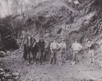
Photograph - Photograph - Reproduction
This reproduced photograph depicts a reef mine in Beechworth. Reef mining, or quartz reef mining, was common in 19th Century Victoria. This gold mining technique requires mine shafts to be sunk into underground quartz reefs, with horizontal tunnels dug from the original shaft at differing levels to find the gold-bearing rock. The quartz would then be hoisted to the surface, which would then be pounded to access the gold in its metallic state. Gold was discovered in Beechworth in February 1852, at Spring Creek. 8000 hopeful prospectors quickly descended on this region within the year, transforming it into a thriving, wealthy township. Reef mining and hydraulic sluicing were gold mining techniques used in this region in the 19th and early 20th centuries. This reproduction photograph interestingly contains dogs alongside the miners. While dogs have been recorded as deterrents to thieves in the Victorian goldfields, these dogs appear as companions to these men.The search for gold is ingrained into the history of Victoria and therefore, images like this one can reveal important information for society and technology for the date when the photograph was taken. It also shows a location where reef mining was undertaken which provides insight into the impact on the environment at a time when it was done. The Beechworth Burke Museum has additional images relating to gold mining which can be analysed and studied alongside images like this one.Black and white rectangular reproduction photograph on gloss photographic paper. Obverse: Reverse: L is miners 26%/ 10 x 8/ 6167.bbeechworth, burke museum, gold, gold mining, gold rush, victorian gold rush, reef mining, quartz, companion dog, horse and cart -
 Stawell Historical Society Inc
Photograph, Double story building on left is Lamont Crushing Battery & on the right is the Oriental Mine looking from the top of the Fire Station c1880's
Photograph taken from the top of the Fire Station 1880's Double story building on left is Lamont Crushing Battery. Behind tree North Cross Reef Mine. Centre No 1 North Cross Reef Mine. On right Oriental Mine.stawell mining -
Bendigo Historical Society Inc.
Document - BOOKLET NOTES - MINING
Handwritten notes to replace items in a booklet. Items mentioned are the Pioneer, Phoenix, Old Chum Coy, divididends, position of engine house in relation to the reef, the Devonshire Group and its location, New St. Mungo, South Devonshire,Suchess of Edinburgh, Princess Alexandra, United Devonshire, West United Devonshire, Hopewell and the Phoenix. Also some sketches of neck of reef, windlass and shaft, chimney and poppet legs. Also a quote for booklet from Cambridge Press on 23-7-68.document, gold, booklet notes, mining, booklet notes, mining, lansell's 222, new chum mines, pioneer, gunther and party, phoenix, old chum coy, p m g repeater station, devonshire group, california gully state school, duke of edinburgh, new st mungo, duchess tribute, south devonshire, duchess of edinburgh, old albert's ground, princess alexandra, united devonshire, the danes, west united devonshire, hopewell, bendigo branch of the royal historical society -
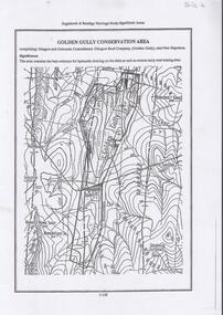 Bendigo Historical Society Inc.
Document - DIAMOND HILL, GOLDEN GULLY COSERVATION AREA
Map of Golden Gully conservation area comprising Glasgow and Golconda Consolidated, Glasgow Reef Company (Golden Gully) and New Napoleon. The area is significant because it contains the 'best evidence for hydraulic sluicing on the field as well as several early reef mining sites' On top of page 'Eaglehawk & Bendigo Heritage Study, Significant areas' Mines marked on page: Goldfields Extended shaft South Concord shaft Concord shaft Morning Light shaft Hansel and Mundy shaftbendigo, mining, golden gully -
 Bendigo Historical Society Inc.
Map - FORTUNA HUSTLER'S MINE - PLAN OF FORTUNA HUSTLER'S MINE
Map and plan of the Fortuna Hustler's Mine on the Hustler's Line of Reefs. Bulletin No 33, Plate No 1. Plan gives depth of the different levels. Bendigo Railway Station is on the map and also a number of the streets. Carpenter Street is called Cemetery Road. Also on the Hustler's Line of Reef is the Summer Hill Shaft. Shown is the Hustler's Royal Reserve No 2 Lease. Map has the Geological Survey of Victoria crest. It is signed by H Whit ? an Underground Survey Office Bendigo, September 1913. map, fortuna hustler's mine, hustler's royal reserve no 2 lease, summer hill shaft, hustler's line of reef -
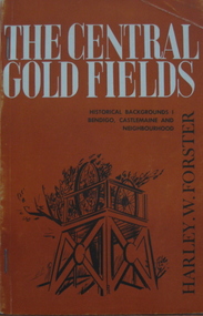 Federation University Historical Collection
Book, Harley W. Forster, The Central Goldfields, 1969
Brown covered book of 80 pages. Topics include gold, McIvor diggings, Tarrangower goldfields, Maldon, quartz reefs, Chinese, land selection, Mt Alexander, Castlemaine, gold licence agitation, glossary. gold license, gold licence, castlemaine, goldfield agitation