Showing 4045 items
matching survey
-
 Bendigo Military Museum
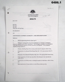
Document - Contingency Support Capability - Army Topographic Support Establishment (ATSE) Implementation, Army Survey Regiment, Bendigo, Apr - Jun 1995
.1 The Minute details that the Army Survey Regiment is maintain a contingency production capability until ATSE is operational. .2 The Minute details the Data Aquisition Squadron requirements during the Implementation to ATSE. .3 The Minute details the Hardware, Software, Personnel and skills required during Implementation to ATSE. .4 The Instruction details that the non-core mapping, charting and geodetic (MC&G) activities of the Army Survey Regiment and 4 Fd Svy Sqn were tested under the Commercial Support Program (CSP) process resulting in the decision to award the contract for the provision of non-core mapping services to the ADF to the Preferred In-House Option (PIHO). .1 Contingency Support Capability - Army Topographic Support Establishment (ATSE) Implementation 26 Apr 95 (11 x A4 pages) .2 Data Acquisition Squadron (DAS) Contingency Support Capability - Army Topographic Support Establishment (ATSE) Implementation Apr 95 (4 x A4 Pages) .3 Contingency Support Capability - Army Topographic Support Establishment (ATSE) Implementation 28 Apr 95 (9 x A4 pages) .4 Directorate of Military Survey - Army Instruction for Implementation of the Army Topographic Support Establishment (ATSE) Jun 95 (10 x A4 pages)royal australian survey corps, rasvy, fortuna, army survey regiment, army svy regt, asr, atse -
 Federation University Historical Collection
Book, Ballarat Performing Arts: A Facilities Usage Survey, 1986
A usage survey for Ballarat performing arts published by the Victorian Ministry for the Arts.victorian ministry for the arts, performing arts, courthouse theatre, her majestys, theatres, memorial theatre, founder hall, mt clear technical school, civic hall, victorian theatre sovereign hill -
Whitehorse Historical Society Inc.
Document, Wandinong Floristic survey, 1993
A survey and management prescriptions for the enhancement of indigenous vegetation and the control of weed species.A survey and management prescriptions for the enhancement of indigenous vegetation and the control of weed species.A survey and management prescriptions for the enhancement of indigenous vegetation and the control of weed species.wandinong sanctuary, native plants, weeds -
 Otway Districts Historical Society
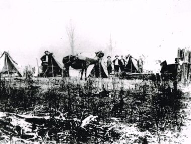
Photograph, Railway survey camp, c.1901, c.1901
Six surveyors and a horse posing outside five tents somewhere on the Beech Forest line in approximately 1901.Photograph, B/W. Railway survey camp, Beech Forest line.survey camp; beech forest; railways; -
 St Kilda Historical Society
Photograph - Photo map, Department of Crown Lands and Survey (1857-1983), 22/01/1970
One of a series of photo-maps produced for the Department of Crown Lands and Survey (1857-1983). For correlation with a current map, and access to other historical photo maps of Victoria, see the Historic Photo-Maps Index published by the Department of Environment, Land, Water and Planning at https://services.land.vic.gov.au/DELWPmaps/historical-photomaps/Black and white aerial photographVic 2358 Department of Crown Lands and Survey Victoria,.© Melbourne 1970 Project Run 41E 22.1.70 5,100 ASL 62caulfield, caulfield north, st kilda east, armadale, 1970 -
 St Kilda Historical Society
Photograph - Photo map, Department of Crown Lands and Survey (1857-1983), 22/01/1970
One of a series of photo-maps produced for the Department of Crown Lands and Survey (1857-1983). For correlation with a current map, and access to other historical photo maps of Victoria, see the Historic Photo-Maps Index published by the Department of Environment, Land, Water and Planning at https://services.land.vic.gov.au/DELWPmaps/historical-photomaps/Black and white aerial photographVic 2358 Department of Crown Lands and Survey Victoria,.© Melbourne 1970 Project Run 42E 22.1.70 5,100 ASL 77st kilda, st kilda east, st kilda marina, elwood, elwood canal, elsternwick park, point ormond, balaclava, mc moran reserve, ripponlea, st kilda botanical gardens, peanut farm, 1970 -
 St Kilda Historical Society
Photograph - Photo map, Department of Crown Lands and Survey, 22/01/1970
One of a series of photo-maps produced for the Department of Crown Lands and Survey (1857-1983). For correlation with a current map, and access to other historical photo maps of Victoria, see the Historic Photo-Maps Index published by the Department of Environment, Land, Water and Planning at https://services.land.vic.gov.au/DELWPmaps/historical-photomaps/Black and white aerial photographVic 2358 Department of Crown Lands and Survey Victoria,.© Melbourne 1970 Project Run 43E 22.1.70 5,100 ASL 208elwood, elwood beach, point ormond, elwood park, elwood canal, mc moran reserve, 1970 -
 St Kilda Historical Society
Photograph - Photo map, Department of Crown Lands and Survey, 22/01/1970
One of a series of photo-maps produced for the Department of Crown Lands and Survey (1857-1983). For correlation with a current map, and access to other historical photo maps of Victoria, see the Historic Photo-Maps Index published by the Department of Environment, Land, Water and Planning at https://services.land.vic.gov.au/DELWPmaps/historical-photomaps/Black and white aerial photographVic 2358 Department of Crown Lands and Survey Victoria,.© Melbourne 1970 Project Run 42E 22.1.70 5,100 ASL 75st kilda, st kilda beach, st kilda marina, point ormond, st kilda pier, 1970 -
 St Kilda Historical Society
Photograph - Photo map, Department of Crown Lands and Survey, 22/01/1970
One of a series of photo-maps produced for the Department of Crown Lands and Survey (1857-1983). For correlation with a current map, and access to other historical photo maps of Victoria, see the Historic Photo-Maps Index published by the Department of Environment, Land, Water and Planning at https://services.land.vic.gov.au/DELWPmaps/historical-photomaps/Black and white aerial photographVic 2358 Department of Crown Lands and Survey Victoria,.© Melbourne 1970 Project Run 41E 22.1.70 5,100 ASL 64st kilda, st kilda cemetery, balaclava, st kilda east, windsor, caulfield north, alma park, 1970 -
 St Kilda Historical Society
Photograph - Photo map, Department of Crown Lands and Survey, 08/01/1970
One of a series of photo-maps produced for the Department of Crown Lands and Survey (1857-1983). For correlation with a current map, and access to other historical photo maps of Victoria, see the Historic Photo-Maps Index published by the Department of Environment, Land, Water and Planning at https://services.land.vic.gov.au/DELWPmaps/historical-photomaps/Black and white arial photographVic 2345 Department of Crown Lands and Survey Victoria,.© Melbourne 1970 Project Run 40 8.1.70 5,100 ASL 77albert park, fawkner park, south yarra, middle park, prahran, windsor, st kilda, st kilda west, 1970 -
 St Kilda Historical Society
Photograph - Photo map, 22/01/1970
One of a series of photo-maps produced for the Department of Crown Lands and Survey (1857-1983). For correlation with a current map, and access to other historical photo maps of Victoria, see the Historic Photo-Maps Index published by the Department of Environment, Land, Water and Planning at https://services.land.vic.gov.au/DELWPmaps/historical-photomaps/Black and white aerial photographVic 2358 Department of Crown Lands and Survey Victoria,.© Melbourne 1970 Project Run 43E 22.1.70 5,100 ASL 206elwood, elsternwick, elsternwick park, 1970 -
 Melbourne Tram Museum
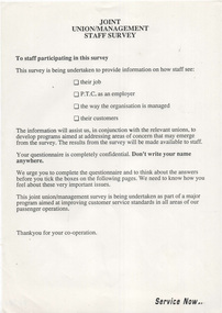
Document - Notice, The Met, Public Transport Corporation, "Joint Union/Management Staff Survey", "Summary of Surveys undertaken in the PTC", early 1990's
.1 - Notice - A4 sheet - titled "Joint Union/Management Staff Survey", not dated, detailing the scope of a survey to be undertaken by the PTC asking information about the feeling for important issues. Has the term "Service Now" in the bottom right hand corner. .2 - A4 Sheet titled "Summary of Surveys undertaken in the PTC", detailing 5 surveys between 1985 and 1990, giving purpose, purpose and benefits - included staff attitudes, equal employment opportunity, consultation, clerical and smoking.trams, tramways, surveys, smoking, ptc, staff, unions, employment -
 Federation University Historical Collection
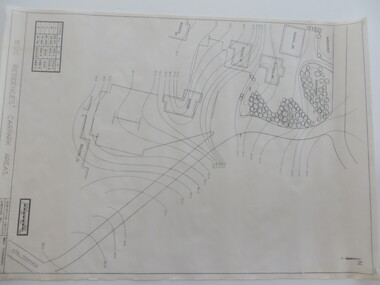
Plan - Contour tracings, Ballarat University College residence carparks and detail survey of Mt Helen campus, 1991/1992
3 ink on tracing paper survey maps .1) Detail survey Mt Helen campus 1992 .2) Top residence car park 1991 .3) BUC residences' car park 1991ink on tracing paper, b.u.c surveys, transpotr, ballarat college of advanced education, mount helen campus, carpark, student residences -
 St Kilda Historical Society
Photograph - Photo map, Department of Crown Lands and Survey, 22/01/1970
One of a series of photo-maps produced for the Department of Crown Lands and Survey (1857-1983). For correlation with a current map, and access to other historical photo maps of Victoria, see the Historic Photo-Maps Index published by the Department of Environment, Land, Water and Planning at https://services.land.vic.gov.au/DELWPmaps/historical-photomaps/Black and white aerial photographCONTROLLED Vic 2358 Department of Crown Lands and Survey Victoria,.© Melbourne 1970 Project Run 41E 22.1.70 5,100 ASL 66st kilda, albert park, st kilda west, catani gardens, st kilda botanical gardens, st kilda pier, st kilda beach, 1970 -
 Ringwood and District Historical Society
Map - Ringwood Animal Welfare Clinic, 1958 Land Survey Drawing, Ringwood, Victoria
Plan of driveway and property east of Heatherdale Road and Canterbury Road corner, with details of house, shed, bungalow, dog pen, kennels and enclosures.Survey by H.L.M. 31-7-58. Scale 20'=1" -
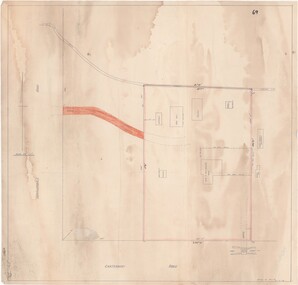
 Federation University Historical Collection
Plan, Underground Survey of Mines at Spring Hill, 1886
Plan printed by the Government Printing Office Melbourne, of underground survey at Spring Hill underground survey, spring hill, robert allen, c.w. langtree, steam litho government printing office -
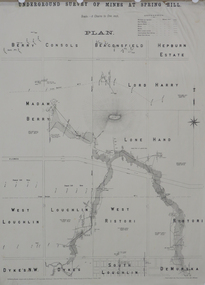
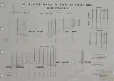 Federation University Historical Collection
Plan, Underground Survey of Mines at Spring Hill Cross Section No 2, 1886
Plan printed by the Government Printing Office Melbourne, of underground survey at Spring Hill.underground survey, spring hill, steam litho government printing office -
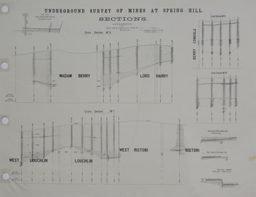 Federation University Historical Collection
Plan, Underground Survey of Mines at Spring Hill Cross Section No 2, 1886
Plan printed by the Government Printing Office Melbourne, of underground survey at Spring Hill.underground survey, spring hill, steam litho government printing office -
Whitehorse Historical Society Inc.
Document, Division of Survey and Mapping, 1984
Information guide to Parish and Township Plans - Division of Survey and Mapping - Victorian Government..Information guide to Parish and Township Plans - Division of Survey and Mapping - Victorian Government..Information guide to Parish and Township Plans - Division of Survey and Mapping - Victorian Government..crown lands, victorian government, land surveys -
Whitehorse Historical Society Inc.
Article, Council to survey recycling habits, 1991
An intensive survey of Nunawading residents recycling habits to be conducted by Litter Research Council.An intensive survey of Nunawading residents recycling habits to be conducted by Litter Research Council.An intensive survey of Nunawading residents recycling habits to be conducted by Litter Research Council.city of nunawading, recycling, hawke, graham, litter research council -
 Bendigo Military Museum
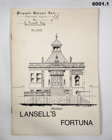
Booklet - Lansell's Fortuna, Army Survey Regiment, Circa 1960
History of Fortuna Villa covering owners and occupiers, the building and the tour during Army tenure. Mentions original owner Christopher Balderstedt, George Lansell and Royal Australian Survey Corps tenures. A number of different versions of this booklet were produced. Each version had a different colour cover. This orange covered edition was the last version produced and printed.6001.1 The white covered version is the first edition of the Fortuna Tour booklet. 6001.2 The orange and off-white covered booklet is the final edition of the Fortuna Tour booklet produced by the Army Survey Regiment, 36 pages, contains black and white photos, colour photos, plans, sketches, maps, diagrams, gloss paper, stapled spline 20cm x 29cm 6001.3 The green covered edition is a second variation of the Army Survey Regiment Tour Bookletroyal australian survey corps, rasvy, fortuna, army survey regiment, army svy regt, asr -
Whitehorse Historical Society Inc.
Document, Division of Survey and Mapping, 1984
A brief guide to Crown Lands And Survey records commonly used for family history research.A brief guide to Crown Lands And Survey records commonly used for family history research.A brief guide to Crown Lands And Survey records commonly used for family history research.crown lands, victorian government, land surveys -
 Ringwood RSL Sub-Branch
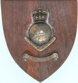
Souvenir - Wooden Plaque, Royal Australian Survey Corps
Wood plaque with brass fittings. Royal Australian Army Survey Corp post 1954 -
 Bendigo Military Museum
Administrative record - Royal Australian Survey Corps - Planning for Field Survey Operations for 1:250,000 - LtCol JK Herridge (RASvy) 1960, LtCol JB Herridge (RASvy), April 1960
This 13 x page document contains notes on planning for RASvy Field Survey Operations in Northern Command during 1958 and 1959 with helicopter support available for field operations for 1:250,000 mapping. The Document was written by LtCol JB Herridge (RASvy) at the School of Military Survey Balcombe April 1960.13 x foolscap pages of typed text, stapled and four holed punchedHand written "53" in top RH cornerroyal australian survey corps, rasvy, fortuna, army survey regiment, army svy regt, asr, school of military survey, sms -
 Bendigo Military Museum
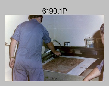
Photograph - Lithographic Technicians preparing a Cromalin map proof at the Army Survey Regiment, Fortuna Villa Bendigo, c1990s
These six photographs were most likely taken in the 1990s in Lithographic Squadron at the Army Survey Regiment, Fortuna, Bendigo. There is no annotation describing the date or personnel in the photographs. Cromalin proofing was a laminate and dry powder proofing system introduced in 1978. The system allowed the production of true to colour proofs, mainly for the proofing of orthophoto maps and process printed 1:250,000 JOG that used positive printing plates. It was upgraded in 1986. The pre-press proof was a cost-effective way of producing a one-off visual copy of the map or chart product. It enabled cartographers to perform a quality inspection and correct any faults before publication. The pre-press proof was deemed authoritative before its release to Print Troop for bulk printing and distribution.This is a set of six photographs of lithographic technicians preparing Cromalin map proofs at the Army Survey Regiment, Bendigo c1990s. The photographs were on 35mm negative film and were scanned at 96 dpi. They are part of the Army Survey Regiment’s Collection. .1) to .6) - Photo, colour, c1990s, printer technician SPR Shona Hastie, Lithographic Squadron. .1P to .6P – no annotationroyal australian survey corps, rasvy, army survey regiment, army svy regt, fortuna, asr, litho -
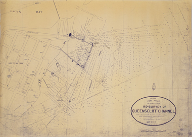 Queenscliffe Maritime Museum
Map - Survey Chart, J. P. Larkin, Re-Survey of Queenscliff Channel, 29 October 1928
A paper chart showing sounding around the Queenscliff Channel dated 1928Victoria Port Phillip October 1928, Re survey of Queenscliff Channelqueenscliff channel, surveying, navigation -
University of Melbourne, Burnley Campus Archives
Document, Graduate Destination Survey 2003, 2004
University of Melbourne, University Planning Officegraduates, survey, 2003, university of melbourne -
 Eltham District Historical Society Inc
Document - Folder, Survey Maps and Technical Drawings
alan gardiner collection, maps -
 Bendigo Military Museum
Poster - Map Production flow chart poster using Automap 2, Army Survey Regiment, Bendigo, 1982
This poster designed to be folded into a brochure describes the second phase of the computer assisted cartographic system to be used by the Royal Australian Survey Corps in the establishment of a topographic data base, Future tactical applications and map products using the data base are displayed. A topographic map of Series R631 1:100,000 Helenvale, Queensland printed on the reverse side that was produced by the Automap system using information from the topographic data base. This is the fifth edition of the poster.A multi colour poster of map production using the Automap 2 system. Poster shows a schematic and pictorial flow chart diagram of the stages of the map production process using the Automap 2 system. The poster was intended to be folded into a small brochure. A 1:100,000 Army Survey Map Series R631, 7966 Helenvale, Queensland Edition 2 is printed on the reverse side of the poster. The map is an example of one of the initial maps produced on the Automap 2 System at the Army Survey Regiment, Bendigo.royal australian survey corps, rasvy, fortuna, army survey regiment, army svy regt, asr, automap 2 -
Whitehorse Historical Society Inc.
Document, City of Nunawading Heritage Survey Project, 1/10/1994 12:00:00 AM
Database of places recognised in the field survey.Database of places recognised in the field survey. List of buildings, roads etc with indexes by value and by street name.Database of places recognised in the field survey. city of nunawading heritage survey, street name