Showing 1123 items matching " waterways"
-
 Lakes Entrance Historical Society
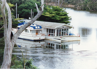
Photograph - Box's Creek, Tambo Shire, 1994
... Waterways ...Also second identical copyColour photograph of a holiday house, built over the water at Box's Creek, a motor cruiser moored beside the house. Metung Victoriawaterways, tourism, boats and boating -
 Lakes Entrance Historical Society
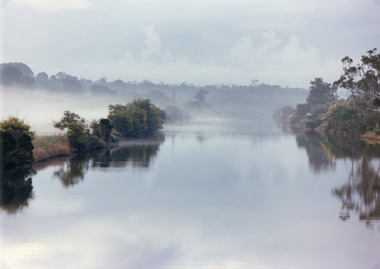
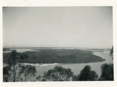
Photograph, 1994
... Waterways ...Also second identical copyColour photograph of the Tambo River, showing mist over the river and banks either side. Swan Reach Victoria vegetation, topography, waterways -
 Lakes Entrance Historical Society
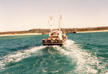
Photograph - Southern Hope, Hammarstrom Ian, 1987 c
... Waterways ...Colour photograph of the fishing boat Southern Hope approaching the entrance channel, from the ocean, shows sandy beach each side of entrance piers and shallow water over the outer bar, sea calm. Lakes Entrance Victoriaships and shipping, waterways, fishing industry -
 Lakes Entrance Historical Society
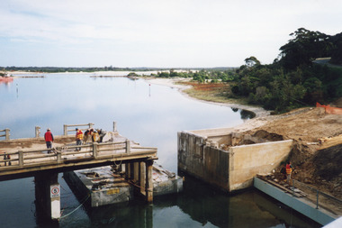
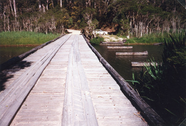
Photograph - Old North Arm Bridge, 2000
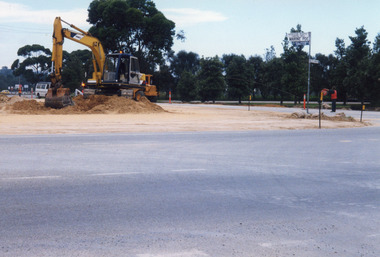
... Waterways ...Date made May 2000Colour photograph showing the activity during the deconstruction of the old North Arm bridge showing cranes lifting handrails, circular saw cutting concrete bridge decking, and top of piers removed. Scene indicates how the bridge was constructed in 1917. Lakes Entrance Victoriabridges, waterways, demolition -
 Lakes Entrance Historical Society
Photograph, 2000
... Waterways ...Date made May 2000.Colour photograph of diving operations to attach crane cable to underwater section of piers of old North Arm bridge. Diver in water, small tinny standing by with two men aboard. Lakes Entrance Victoria.bridges, waterways, public works -
 Lakes Entrance Historical Society
Photograph - North Arm Bridge, 2008
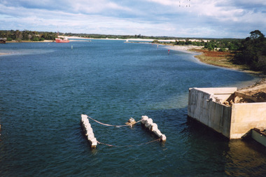
... Waterways ...Date made September 2008Colour photograph showing the new North Arm bridge opened 2000, taken from pathway besides Princes Highway at west end of Lakes Entrance, Victoria.bridges, waterways, roads and streets -
 Lakes Entrance Historical Society
Photograph, 1999
... Waterways ...Date made January 1999 - June 2000Colour photograph of North Arm bridge under construction. Lakes Entrance Victoriabridges, waterways, public works -
 Lakes Entrance Historical Society
Photograph - tramline Lake Bunga, 1919
... Waterways ...Three identical black and white copies, 8 x 10 cmSepia photograph showing Lake Bunga near Lakes Entrance, with tramline across lake with one panel missing. Lake full and clean. Hard to see whether the entrance is open or closed. (After 1919) Lake Bunga VictoriaLake Bunga Vic (on reverse)transport, waterways, tramline -
 Lakes Entrance Historical Society
Photograph - Bridges, 1998
... Waterways ...Also photograph of bridge from different angleColour photograph of the crossing at Toorloo Arm on the previous main road from Lakes Entrance to Nowa Nowa known as Burnt Bridge. Lakes Entrance Victoriabridges, waterways, vegetation -
 Lakes Entrance Historical Society
Photograph - Bullock Island, 1915c
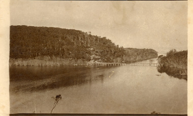
... Waterways ...On back of original 'To Rit with love from Arthur' (Arthur Seagrove - Head Teacher, Johnsonville Primary School - 1920)Black and white photograph of Bullock Island and the man-made entrance from Bass Strait. It shows the Western end of Bullock Island, some natural vegetation, jetty and timber groynes, trading vessel standing outside entrance. Lakes Entrance Victoriawaterways, islands, topography -
 Lakes Entrance Historical Society
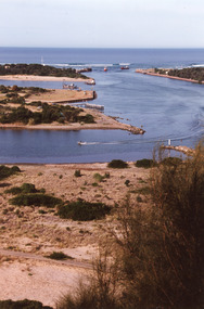
Photograph - The Entrance, 1995c
... Waterways ...Colour photograph of the entrance from Bass Strait to the Gippsland Lakes, it shows the western end of Bullock Island and the built up area below Jemmys Point, both made during dredging operations over many years. Lakes Entrance Victoriaislands, fishing industry, waterways -
 Lakes Entrance Historical Society
Photograph - The Entrance, 1995c
... Waterways ...Colour photograph of the entrance from Bass Strait to the Gippsland. It shows the western and of Bullock Island and the built up area below Jemmys Point, all made during dredging operations over many years. Lakes Entrance Victoriafishing industry, islands, waterways -
 Lakes Entrance Historical Society
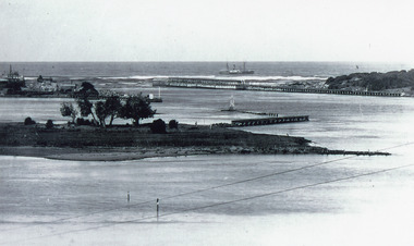
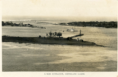
Photograph - The Entrance, Martin Orville, 1940c
... Waterways ...Another copy Black and white 7 x 8.5 with inscription'View showing the Entrance, Lakes Entrance, Vic'Black and white photograph of Bullock Island, the New Works, township and entrance from Bass Strait to the Gippsland Lakes. Taken at high tide. Lakes Entrance Victoriaislands, waterways, topography -
 Lakes Entrance Historical Society
Postcard - Bullock Island, Bulmer H D, 1923c
... Waterways ...Also same image|Faded copy 10x15|Black and White 12x17.5|Black and White 20x28.5Black and white postcard of the entrance to the Gippsland Lakes, showing buildings at New Works, cranes on ends of piers, jetty and bathing boxes on bullock Island, steamer passing island. Lakes Entrance VictoriaLakes Entrance, Gippsland Lakeswaterways, islands, topography -
 Lakes Entrance Historical Society
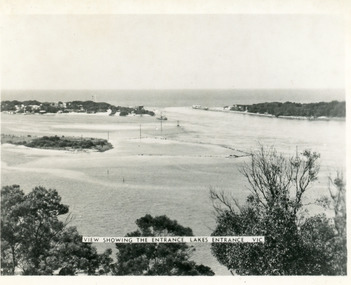
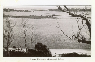
Photograph - The Entrance, 1922c
... Waterways ...Black and white copy 9.5 x 15|Black and white copy 12x18Black and white photograph of the entrance and Bullock Island. It shows the western end of Bullock Island with bathing boxes, rock groynes, and sandy shore beneath Jemmys Point. Lakes Entrance VictoriaLakes Entrance, Gippsland Lakesislands, waterways, topography -
 Lakes Entrance Historical Society
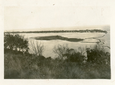
Photograph - Bullock Island, 1930c
... Waterways ...Black and white photograph of Bullock Island, showing the footbridge to the island, the rock groynes at the western end of the island, built to direct flood and tide waters to entrance. Photo taken from Kalimna Hill, scub in foreground. Lakes Entrance Victoriawaterways, islands, township -
 Lakes Entrance Historical Society
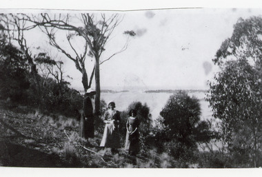
Photograph, 1920c
... Waterways ...Black and white photograph showing three women at viewing site Kalimna of the Entrance to Bass Strait from the Gippsland Lakeswaterways, topography, people -
 Lakes Entrance Historical Society
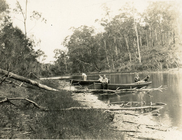
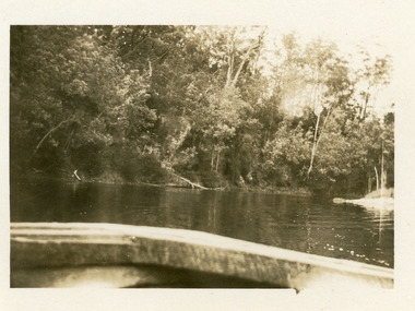
Photograph - North Arm, 1950c
... Waterways ...Black and white photograph of the narrow upper reaches of the North Arm. It shows four people and dog at two small boats on bank. Steep tree covered hillsides above sandy shoreline. Lakes Entrance Victoria vegetation, waterways, recreation -
 Lakes Entrance Historical Society
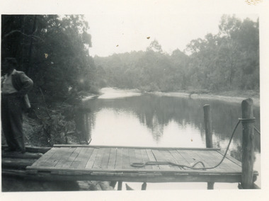
Photograph - Comer's Landing, 1950c
... Waterways ...Black and white photograph showing upper reaches of the North Arm, with Comer's boat landing below Mrs Comer's Tea Rooms. Man on landing, reflections on water. Lakes Entrance Victoria waterways, jetties, restaurant -
 Lakes Entrance Historical Society
Photograph - Butcher's Paddock, Hanlon, Vera, 1940c
... Waterways ...Historic home at 90 Captenter St 'Corrumbene' is pictured on right hand side of photograph. Godsell's house opposite on Western side of North ArmBlack and white photograph showing view of lower reaches of North Arm, part of town, Cunninghame Arm and sand dunes in background, and North Arm on right. Photo taken from Allens Hill, Myer St, vacant paddocks in foreground, known as Butcher's Paddock, slaughterhouse and buildings in mid view. Lakes Entrance Victoriatownship, waterways, animals -
 Lakes Entrance Historical Society
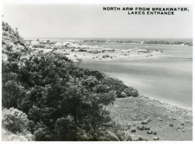
Postcard - North Arm Lakes Entrance, 1945c
... Waterways ...One other copy same sizeBlack and white small format postcard of the entry to the North Arm, taken from Jemmys Point. It shows a steep cliffside above the calm waters, township of Lakes Entrance and Cunninghame Arm, and sand hummocks of southern shore in distance. Lakes Entrance VictoriaNorth Arm from Breakwater - Lakes Entrancetownship, waterways, topography -
 Lakes Entrance Historical Society
Photograph - Comer's Landing
... Waterways ...Black and white photograph of the North Arm at Comer's Landing, North Arm, showing a tree covered steep bank opposite Mrs Comer's Tea Rooms, viewed over the back of a tourist launch. Lakes Entrance Victoriarestaurant, tourism, waterways -
 Lakes Entrance Historical Society
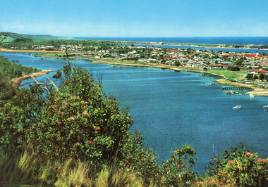
Postcard - Lakes Entrance, Engelander John & Co Pty Ltd, 1980c
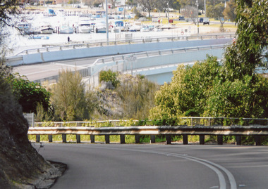
... Waterways ...Panoramic view of Lakes Entrance taken by Melbourne firm for West Germany A.F.K. International Publishers of world's most famous beauty spotsColour postcard with serrated edge, of the township, situated between Cunninghame Arm and North Arm. Boats moored at jetties and beside boat ramps in North Arm. Photo taken from Kalimna Heights. Dredged sand dumped in North Arm bight. Lakes Entrance VictoriaLakes Entrance, Victoria, Australia (on back) waterways, topography, township -
 Lakes Entrance Historical Society
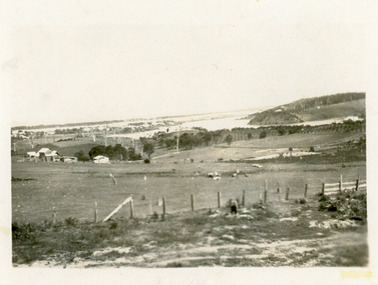
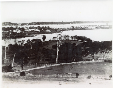
Photograph - Lakes Entrance, 1935c
... Waterways ...Enlarged from postcard produced for Mrs Allen to advertise Allen's Tearoom at the brow of Myer St hill, known as Allen's Hill to locals.|This is the paired before photograph showing the left hand side on Butchers paddock in the panoramic views, the right hand side number 01715. This photograph used in the 150 year Lakes Entrance 1858-2008 display.Black and white photograph of the township, taken from Allen's Hill, Myer St. It shows the town between Cunninghame Arm and North Arm, cleared and fenced paddocks in foreground, New Works village and sand hummocks in distance. Lakes Entrance Victoria township, waterways, topography -
 Lakes Entrance Historical Society
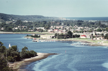
Photograph - Lakes Entrance, Fraser, Ian, 1985c
... Waterways ...Colour photograph of the township, situated between Cunninghame Arm and North Arm. Boats moored in North Arm. Scrub covered hummocks of southern shore in background, taken from cleared vantage point on Kalimna Heights. Lakes Entrance Victoria boats and boating, waterways, township -
 Lakes Entrance Historical Society
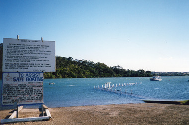
Photograph - North Arm Lakes Entrance, Holding M, 2000
... Waterways ...Date made January 2000Colour photograph of high tide in the North Arm. It shows the boat ramp and jetty under water, boat moored in lake, pelican fishing nearby. Warning and instruction signs on shore. Kalimna Heights in background. Lakes Entrance Victoriaboats and boating, waterways, safety -
 Lakes Entrance Historical Society
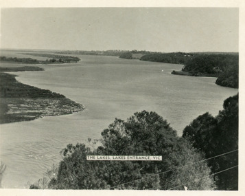
Postcard - Reeves Channel, Valentine Series, 1930c
... Waterways ...Other copy similar view with inscription 'The Lakes, Lakes Entrance Vic'Black and white postcard of Reeves Channel Gippsland Lakes, showing Rigby, Fraser and Flannagan Islands opposite the steep shoreline of the mainland. Natural vegetation of Jemmys Point in foreground from which photograph was taken. Lakes Entrance VictoriaKalimna from Jemmys Point Lakes Entranceislands, waterways, topography -
 Lakes Entrance Historical Society
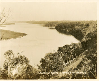
Postcard - Reeves Channel, Valentine Series, 1930c
... Waterways ...Black and white small format postcard of Reeves Channel Gippsland Lakes, taken from Jemmys Point. It shows a glimpse of the Princes Highway, the steep shoreline of the mainland opposite Rigby Island with Fraser Island and Flannagan Island in distance. Lakes Entrance VictoriaKalimna Cove Lakes Entranceislands, waterways, topography -
 Lakes Entrance Historical Society
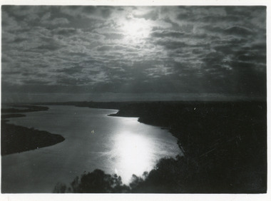
Postcard - Reeves Channel, 1930c
... Waterways ...3 identical 6 x 8.5|1 same size hand tinted 6 x 8.5Black and white small format postcard of a sunset scene on Reeves Channel, Gippsland Lakes. It shows sunlight reflected through clouds and on the lake between Rigby Island and the mainland. Lakes Entrance Victoriaislands, waterways, topography -
 Lakes Entrance Historical Society
Photograph - Rigby Island, 1930c
... Waterways ...Second copy similar viewBlack and white photograph of Rigby Island, Gippsland Lakes Victoria. It shows Reeves Channel on right of photo, Hopetoun Channel on left, The Narrows below Jemmys Point from which photo was taken. Lakes Entrance Victoriaislands, waterways, topography