Showing 8342 items matching "bridges"
-
 Kinglake Historical Society
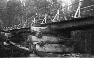
Log Bridge Kinglake
post card depicting horse and cart crossing log bridge at Kinglakeearly post card of Kinglake area including bridge and transportpost card of log bridge Kinglakekinglake, post card, log bridge, horse cart -
 Eltham District Historical Society Inc
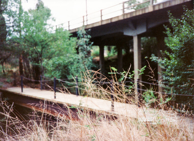
Photograph, Diamond Creek Trail bridge, Eltham South
... bridges ...Colour photograph of the Diamond Creek Trail bridge over the Diamond Creek near Eltham Lower Park; Main Road bridge in backgrounddiamond creek trail, bridges, eltham, main road -
 Lakes Entrance Historical Society
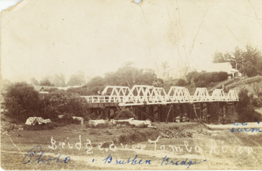
Postcard - Bridge over Tambo, 1906 c
... Bridges ...Letter dated 20 February 1907 written on back to Miss Clark Turnbull Bairnsdale from E W B Batton Bruthen 2 penny stamp Queen VictoriaBlack and white postcard of the bridge over the Tambo River with Star Hotel visible on the hill, logs on ground below bridge Bruthen Victoriabridges, ships and shipping, waterways, hotels -
 Lakes Entrance Historical Society
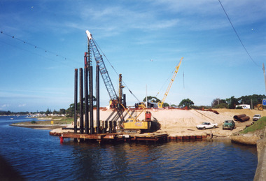
Photograph - North Arm Bridge, Davies Judy, 1999
... Bridges ...Date made 10 April 1999Colour photograph of the southern abutment of the now North Arm Bridge during construction. Three cranes in attendance distant view of North Arm waterway, taken from walkway on old concrete road bridge. Lakes Entrance Victoriabridges, construction -
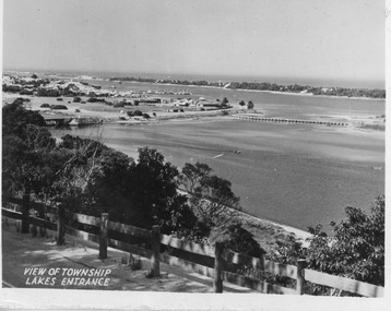 Lakes Entrance Historical Society
Postcard - North Arm bridge Lakes Entrance Victoria, 1947c
... Bridges ...Black and white small format postcard showing town, North Arm bridge, post and rail fence beside the road, bridge to Bullock Island, Cunninghame Arm and sand hummocks, motor boat on the lake. Lakes Entrance VictoriaView of Township Lakes Entrancebridges, township -
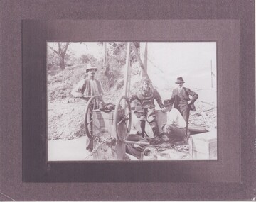 Rutherglen Historical Society
Image
Extracts from the entry for the bridge in the Victorian Heritage Database: "The bridge is of also of historical significance for its association with the prominent local identity and pioneer businessman John Foord, who was involved in the company that erected the 1862 timber bridge on the site. ... When the new bridge was built as a replacement, it took the same name." This second bridge (the current one) was opened in January 1893, Photocopy of a photograph of four men, one in old style diving suit. Copy is mounted on board made of what appears to be a thin layer of Styrofoam sandwiched between two layers of glossy paper.Written on back of mount: "During building of 2nd John Foord Bridge"john foord, bridge construction, diving, corowa, wahgunyah -
 Kiewa Valley Historical Society
Photos - Tawonga Bridge x 2
The first Tawonga bridge was built in 1884. It was destroyed by floods in 1916. The new bridge was constructed in 1923 and destroyed in 1953. The present concrete bridge was constructed in 1986 and named Ryders Bridge. Also refer to ?KVHS 0962 and KVHS 1051, KVHS 1090, KVHS 1123Bridge constructed over the Kiewa River in 1923 and destroyed in 1953.1. Dark Brownish photo framed by thin wood. Photo shows bridge with mountain behind and river and river bank in the foreground. 2. Small photo showing 2 sides of the bridge - a close up view.tawonga bridge, kiewa valley, kiewa river -
 Whitehorse Historical Society Inc.
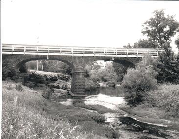
Photograph - Black and white photograph, Bridge on Blackburn Road. Blackburn
... bridges ...B/W photo mounted on board depicting bridge at Blackburn Road with car in picture.bridges, blackburn road blackburn -
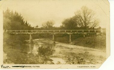 Clunes Museum
Photograph, FOOT BRIDGE, CIRCA 1920
... bridges ...POST CARD PHOTOGRAPH OF FOOTBRIDGE IN CLUNES OVER TULLAROOP CREEK. TAKEN ABOUT 1920.FOOT BRIDGE CLUNES. VALENTINES M 5982local history, photographs, bridges, foot bridge -
 Glenelg Shire Council Cultural Collection
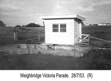
Photograph - Photograph - Portland Harbour Trust - Weigh Bridge, Victoria Parade, 1953
Port of Portland Authority archivesFront: (no inscriptions) Back: P.H.T./ Print No. 4/21 Neg. No ..../ Date taken 28-7-53/ SUBJECT./ Weigh Bridge. / Victoria Parade. (Ink stamp with blue pen and pencil additions, centre)port of portland archives -
 Linton and District Historical Society Inc
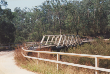
Photograph, Dilapidated bridge over Springdallah Creek, Happy Valley/Piggoreet, 2010
This bridge was built in the 1880s. By the 1980s it was in a dilapidated condition and was replaced. The old bridge was further damaged by storms and flooding in November 2010 and January 2011. (The newer bridge was completely washed away when the Springdallah Creek flooded in January 2011.) In 2025, little remains of the old bridge.Colour photograph of a trestle bridge spanning Springdallah Creek, Linton-Piggoreet Road.trestle bridges, old springdallah bridge -
 Stawell Historical Society Inc
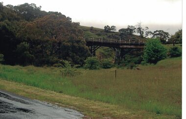
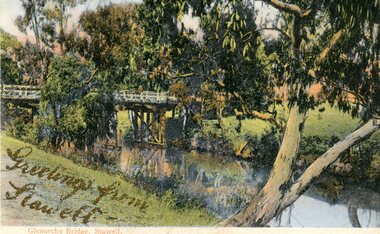
Photograph, Greetings from Stawell - Glenorchy Bridge -- Postcard
Postcard Front - Glenorchy bridge over water with gums in colourGreetings from Stawell - Gold Pen. Bridge supports. Note from Mother. also gold pen. Also parts of trees -
 Ringwood and District Historical Society
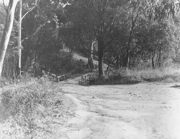
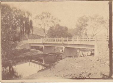
Photograph, Deep Creek Road bridge early 1900s
Black and white photograph taken from unmade road. Road zigzags over bridge with wooden balustrades. Bushland setting. (3 copies)Typed below photograph, "Deep Creek Road bridge in the early days". -
 The Beechworth Burke Museum
Photograph, c. 1927 - 1930
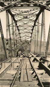
Taken during the construction of the Bethanga Bridge (1927-1930), this sepia photograph shows a view of the incomplete bridge taken from inside the structure and looking down the span of the bridge from where the photographer stands. The photograph depicts an incomplete deck, with loose-looking wooden planks/panels lain along the centre in groups of three. Once complete, the original decking of the bridge was made of timber before being replaced by cement in 1961 (Victorian Heritage Database).Bethanga Bridge is of historical significance to the Indigo Shire for its associations with the construction of Hume Dam, its associations with the River Murray Waters Agreement and the River Murray Commission, and illustration of the needs and influence of the farming communities along the river in this area - particularly in relation to the building of the Weir. It also represents the collaboration between New South Wales and Victoria on a large infrastructure project, being the only built structure shared by both New South Wales and Victoria due to its location. also reflecting on the Shire's geographical closeness to this neighboring state. This photograph is part of a series that documents the construction of this well-known heritage site of significance to the Indigo Shire. It reflects upon a period of growth and change in the area.Sepia, rectangular photograph printed on matt photographic paper, unmountedReverse: 1997.3190 / Another snap of the bridge. taken on the bridge showing huge steel sides / 84-19-4 / V [in circle] 354 / KODAK PRINTbethanga bridge, hume dam, bridges album, construction, road construction, hume weir -
 Ringwood and District Historical Society
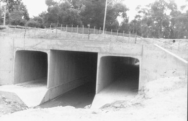
Photograph, Mullum Mullum Creek culvert installations for new bridge in Warrandyte Road, Ringwood - 19.1.1987
Culverts under new Warrandyte Rd. bridge. Mullum Mullum Creek, Ringwood 1987Written on back of photograph, "9.1.87. Culverts under new Warrandyte Rd. bridge. Mullum Mullum Creek." -
 Lakes Entrance Historical Society
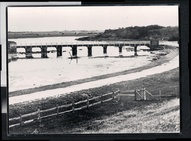
Photograph - North Arm bridge Lakes Entrance Victoria, 1935c
... Bridges ...Black and white photograph of North Arm Bridge, taken from Bullock Island. Vehicle on bridge, two houses visible on cleared area of timbered Kalimna Heights. Lakes Entrance Victoriabridges, waterways, transport -
 Lakes Entrance Historical Society
Photograph - Murrindal River Bridge Murrindal Victoria, 1/03/2000 12:00:00 AM
... Bridges ...Colour photograph of the timber bridge across the Murrindal River Murrindal Victoria. Also a second colour photograph showing approach to bridge with signs prohibiting cattle droving and use of side track.bridges, forest, civil engineering -
 Hume City Civic Collection
Photograph, 1970s
The bluestone bridge which spans the Jacksons Creek was built in 1857 and replaced a laminated timber bridge. In the 1970s the stone bridge was replaced with a wider cement structure to accommodate the increased traffic flow.A black and white photograph of the bluestone Macedon road bridge over the Jacksons Creekmacedon street road bridge, harris, thomas lascelles, jacksons creek, george evans collection -
 Port Fairy Historical Society Museum and Archives
Photograph - Photograph,copy
Port Fairy Moyne river bridgeBlack and white photograph of Moyne river traffic bridgebridge, moyne river, low tide, griffith street -
 Port Melbourne Historical & Preservation Society
Photograph - Centenary Bridge, Port Melbourne, c.1991
Centenary Bridge prior to demolition in 1991.From Centenary Bridge looking towards St Kilda built environment - civic, centenary bridge -
 Stawell Historical Society Inc
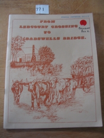
Book, Peter Davie, From Ledcourt Crossing to Dadswells Bridge, 1980
History of Dadwells bridge area. Written for the Back-To-School. 75th Anniversary Different families of the district contributed articles & Photographs Fawn Card cover with brown print and drawing of a house with a bullock wagon in front. surround by a single line borderFrom Ledcourt crossing to Dadswell Bridgestawell -
 Port Fairy Historical Society Museum and Archives
Photograph
Moyne Bridge & Gardens 1904/06Black and white Photograph glued to cardboard Bridge and Gardens Port Fairy R. Scott photomoyne bridge, gardens, traffic, griffith street -
 Kiewa Valley Historical Society
Photo - Tawonga Bridge.( Set of 2 photos)
Photo 1 - Rene Roper (Postmistress) crossing swollen Kiewa River on a milk can flying fox at Tawonga, during high winter waters Photo 2 - First Tawonga bridge was built in 1884- destroyed by floods in 1916. New bridge constructed 1923 and destroyed in 1953. Present concrete bridge constructed in 1986 and named Ryders BridgeBridge construction over Kiewa River at TawongaCopies of two original black and white photos. Photo 1 - Flying fox at site of Tawonga Bridge over the Kiewa River Photo 2 - Timber pile bridge over the Kiewa River at Tawongatawonga bridge, kiewa valley -
Phillip Island and District Historical Society Inc.
Photograph, 1968
... Bridges ...Part of an album compiled and donated by Mrs Helen Jansson. Construction of second Phillip Island Bridge to San Remo. 1968/69.Sea level close up of placing of centre span with crane at left and men on left on centre span at right. Looking into Western Port Bay. Second Bridge under construction 1968Descriptive caption underneath "92'"local history, photography, photographs, slides, film, civil engineering, bridges, phillip island bridge 1968, black & white photograph, mrs helen jansson, second phillip island bridge 1968/69 -
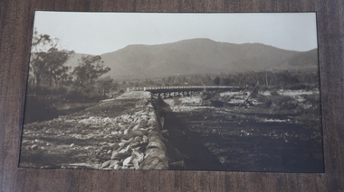
 Orbost & District Historical Society
black and white photograph, first half 20th century
This is the Dalgety bridge across the Snowy River. It is a steel construction.The first bridge over the river was constructed in 1888. There was a punt across the river before the bridge was built . Dalgety is a small service centre, located on the Snowy River approximately 235 km from Orbost. It was an early consideration for the site of Australia,s capital city. The Dalgety Bridge over the Snowy River has been an important item of infrastructure in the history of New South Wales for over 110 years. It was designed by noted bridge engineer J. A. McDonald,and was a technically sophisticated bridge structure for its time. This is a pictorial record of a significant structure on the Snowy River.A small black / white photograph of a large bridge over a river.bridge-dalgety-snowy-river -
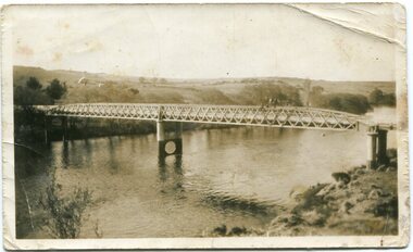
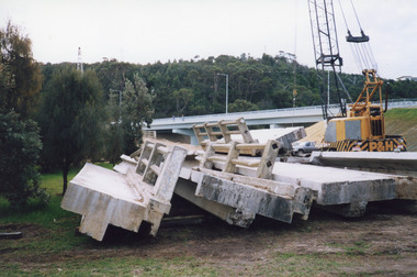 Lakes Entrance Historical Society
Photograph - Old North Arm Bridge, 2000
... Bridges ...Date made May 2000.Colour photograph of stacked sections of the old concrete North Arm bridge, Lakes Entrance, Victoria.bridges, demolition -
Lakes Entrance Historical Society
Book, McGrath, Michelle, Trestle Bridge, 2005
... Bridges ...Research, interpretation and management recommendations for the trestle bridge at Stony Creek, Nowa Nowa, Gippsland, VictoriaConservation and Land Management Culture Analysis Reporttransport, bridges -
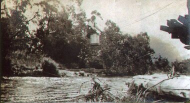
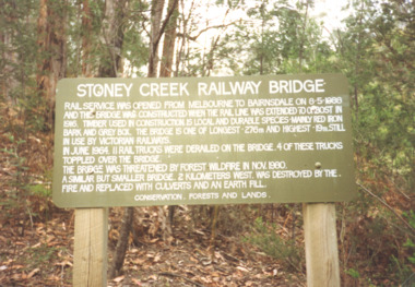 Lakes Entrance Historical Society
Photograph, Davies Judy, Stoney Creek Bridge Nowa Nowa Victoria, c1990
... Bridges ...Colour photograpf of the sign erected by the Conservation, Forests and Lands Dept. at the Stoney Creek Bridge Nowa Nowa Victoria . Plus two other photos of the bridgebridges, forestry, tourism, topography -
 Greensborough Historical Society
Photograph - Digital image, Charles Marshall et al, New bridge, 1917-1918
This photograph shows a new bridge location unclear.Digital copy of black and white photograph. "New bridge [last word illegible, possibly Gaza]"charles marshall, world war 1 -
 Lakes Entrance Historical Society
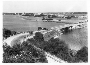
Photograph - North Arm bridge Lakes Entrance Victoria, 1935c
... Bridges ...Black and white photograph of view of concrete North Arm Bridge, showing highway to town, Cunninghame Arm, sand hummocks, vegetation, touring car approaching bridge, and three cars parked at town end of bridge, electricity and telegraph poles. Lakes Entrance Victoriatownship, vegetation, transport, bridges