Showing 10091 items matching "demolished"
-
 Whitehorse Historical Society Inc.
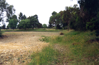
Photograph, Narmara Primary School, 13/01/1994 12:00:00 AM
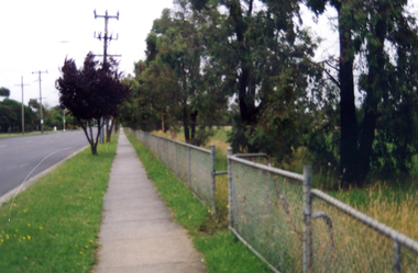
Coloured photo of Narmara Primary School site looking West along Highbury Road. School on North side of Highbury Road between Middleborough and Blackburn Roads. Since demolished and site developed for housing.narmara primary school, warner, philip -
 Whitehorse Historical Society Inc.
Photograph, 6 Edward Street, Mitcham, 1/11/1991 12:00:00 AM
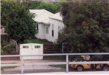
Coloured photo - 6 Edward Street, Mitcham. Built 1890 - 2 Additions Post World War Two. Demolished. Replaced as part of a pair of semi-detached dwellings with Number 4 Edward street.edward street, mitcham -
 Whitehorse Historical Society Inc.
Photograph, House in Queen Street Mitcham
Coloured print from a 110 slide of house in Queens Street, Mitcham, (Raglans) demolished c1974. Shows details of the Australian Tesselated Tile Co. products used|See also NP1210 AND NP1214 - NP1216queen street mitcham, raglans, australian tesselated tile co. pty ltd -
 Kew Historical Society Inc
Work on paper, Joy Stewart, Southesk, c. 1978
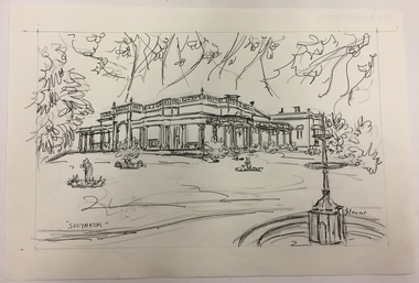
Sydney Joy (joy) Stewart (1925-2018) was a founding member of the Kew Historical Society, and during the 1970s its secretary. During her residence in Kew, she completed numerous property illustrations on commission. These ranged from preliminary sketches, including architectural details to finished pen & ink and wash illustrations on paper. On moving to Queensland, Joy Stewart donated the remaining property illustrations in her possession to the Kew Historical Society. In 1987-88, she fulfilled a commission by the Society of designs for a series of embroideries completed by residents during the Australian Bicentennial commemorations.Sydney Joy (Joy) Stewart was born in Melbourne 1925. She studied at Swinburne Technical College Art School from 1941-1945, then the National Gallery Art School 1946-1948. Her career included employment positions as a display artist, designer/painter, gallery assistant, and art teacher. Joy relocated to Cairns in 1981. Solo exhibitions in Melbourne and Cairns, including 'Done By Me' at Cairns Regional Gallery in 1999. Group exhibitions at Cairns Regional Gallery, 'The Fish John West Regrets, 1993' and 'Facets of Life' 1994. Joy Stewart died in Cairns in 2018.Pencil, pen & Ink sketch on paper of 'Southesk' (demolished) in Cotham Road, Kew by the artist Joy Stewart. To see the image at the next stage as an image created with watercolour, pen and ink on paper, see 1980.0013.Inscription: "Southesk". Signed lower right: "JStewart". c.1978ordsall, cotham road (kew), southesk -
 Kew Historical Society Inc
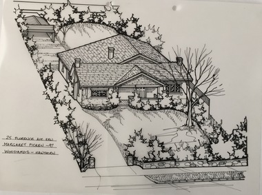
Drawing - Property Illustration, Margaret Picken, 25 Florence Avenue, Kew, 1997
This architectural drawing is one of a series created by Margaret Picken for a number of real estate agents in Melbourne between 1983 and 2005. Each work is signed and dated by the artist.Gift of Margaret Picken, 2020Pen and ink architectural drawing on drafting film of 25 Florence Avenue, Kew; made by Margaret Picken in 1997. A permit to demolish the house was granted by the City of Boroondara in 2006. A new house was subsequently erected.25 FLORENCE AVE., KEW / MARGARET PICKEN '97 / WOODARDS ~ HAWTHORNartist -- margaret picken 1950-, architectural drawings -- houses -- kew (vic.), 25 florence avenue - kew (vic). -
 Port Melbourne Historical & Preservation Society
Financial record, Pat Grainger, Port Melbourne Historical & Preservation Society Annual Report 1996, Aug 1996
PMH&PS was incorporated in 1994, and from 1995 was required to hold an AGM and present an Annual Report. These were compiled, designed, printed on photocopier and bound by the Secretary, except for the Tenth anniversary edition.Annual Report of the PMH&PS, 1996 A5 8 pp plus cover - khaki, with photo of Town Hall, Contains financial reports, list of members and photo of recently demolished Missions to Seamen buildingsocieties clubs unions and other organisations, port melbourne historical & preservation society, pmhps, annual report, glen cosham -
 Eltham District Historical Society Inc
Photograph, Cottage, corner Main and Reynolds roads, Research, Vic, 1986
Wal and Bernie Dodkins, rented the house from Miss Reynolds probably from around 1938 until they left in the 1970s to become caretakers at the Kangaroo Ground Tower. Lyn Dodkins (wife of Graeme Hardiman) was born there and lived in this house for her first 19 years. [Graeme Hardiman email 5 Aug 2022]Six colour photographs of old cottage corner Main and Reynolds roads at Research in 1986. The cottage was built by/for Grandfather Reynolds and was demolished 2 Mar 1987. Three views show widening of Main Road.houses, main road, reynolds road, research (vic.), lyn dodkins, wal dodkins, bernie dodkins, miss reynolds -
 Whitehorse Historical Society Inc.
Photograph - ColouredPhotograph, Narmara Primary School, 13/01/1994 12:00:00 AM
Coloured photo of Narmara Primary School, looking North from south boundary. School on North side of Highbury Road between Middleborough Road and Blackburn Road. Since demolished and site developed for housing.narmara primary school, warner, philip -
 Eltham District Historical Society Inc
Negative - Photograph, Hill family home, Bridge Street, Eltham, c.1892
Mrs. Henry Hill (nee Georgina Reynolds of Research), mother of Arthur Ernest Hill (1891-1961). Taken outside the old Hill family home in Bridge Street, south side between Susan and Bolton Streets. Demolished many years prior to 1965. Georgina Reynolds (1864-1927) married Henry Hill (1862-1948) in 1884. Arthur Ernest Hill was married to Edna Hill. Edna Hill donated the postcard to the Shire of Eltham in 1965, four years after her husband Arthur Ernest Hill's death. At the time she did not know the identity of the others in the photo but it is possible that it is Henery Hill and baby Arthur Ernest Hill.This photo forms part of a collection of photographs gathered by the Shire of Eltham for their centenary project book,"Pioneers and Painters: 100 years of the Shire of Eltham" by Alan Marshall (1971). The collection of over 500 images is held in partnership between Eltham District Historical Society and Yarra Plenty Regional Library (Eltham Library) and is now formally known as the 'The Shire of Eltham Pioneers Photograph Collection.' It is significant in being the first community sourced collection representing the places and people of the Shire's first one hundred years.Digital image 4 x 5 inch B&W Neg Sepia postcard 8.5 x 13.5 cmOn reverse of postcard: Mrs Henry Hill (nee Georgina Reynolds of Research) Mother of Arthur Ernest Hill. Identity of others not known to Mrs A.E. Hill, who states 'photo was taken outside the old Hill residence, Bridge St, (south side between Susan St. & Bolton St.) Demolished many years ago - 26.7.65 Also stamped - Shire of Elthamsepp, shire of eltham pioneers photograph collection, eltham, georgina hill (nee reynolds), hill residence, bridge street, hill family, hill family home, houses, mrs henry hill, arthur ernest hill, henry hill -
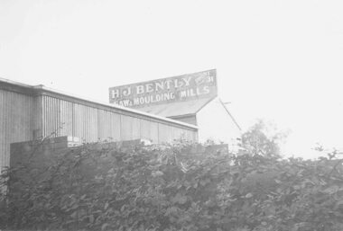 Ringwood and District Historical Society
Photograph, H.J. BentleysTimber Yard and Boiler House Demolition, Ringwood 1959. (4 views)
Written next to photographs: SS0180a: "Timber racks in B. Timber yard. Now demolished. 1959. Taken from Matlocks Stables." SS0180b: "Boiler house and workshop being pulled down." SS0180c: "Bentleys from Warrandyte Rd. Pipes etc. in backyard of Bissetts shop, corner Main Street." SS0180d: "Further snap of boiler house being demolished." -
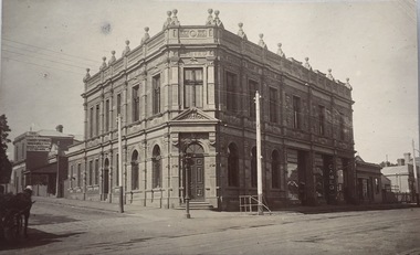
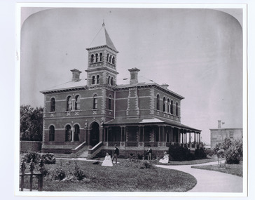 St Kilda Historical Society
Photograph, Donald McDonald, Euro Reko, c.1872
Front view of two storey mansion, central tower, polychrome brick, arched windows and single storey verandah to right side of building. Two couples in garden foreground. Built 1860, photograph taken 1872. Designed by Reed and Barnes.backed, unmounted copy, black and white photo, good condition.Built 1860, designed by Reed and Barnes, Euro Reko, Burnett Street S E side, through to Gurner Street. Photograph taken 1872. Demolished.' -
 Whitehorse Historical Society Inc.
Photograph, Mitcham Hospital
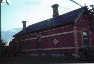
Copy of black and white photo of 'Warrender' Mitcham Private Hospital, corner McDowall and Harrison Streets, Mitcham, since demolished. Owned by Dr. Stanley Cochrane.|Cross Ref: Photos NP1791 1-2| NP1794warrender hospital, mitcham private hospital, cochrane, stanley dr -
 Whitehorse Historical Society Inc.
Photograph, House in Queen Street Mitcham
Coloured print of a 110 slide of the detail of a house in Queens Street, Mitcham; demolished c1974. Shows detail of the Australian Tesselated Tile Co. products used in the building.|See also NP1210, NP1214 & NP1216-7queen street mitcham, australian tesselated tile co.pty ltd -
 Kew Historical Society Inc
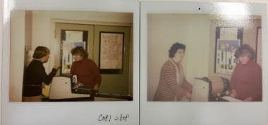
Photograph - 'Copy Shop', Old Masonic Hall, Walpole Street
The 'Copy Shop' in Walpole Street, Kew was located in the former Masonic Hall. It was a community operated facility. The 'shop' was designed for use by groups to run off leaflets or newsletters. It also served as a community space where people could drop in for a coffee and leave leaflets and information about events in the City of Kew. Two polaroid photographs, Thea Sartori in a red jumper is in both photographs. The woman in the pink cardigan is Aileen Cahill. Both photos were taken at the 'Copy Shop' in the old Masonic Hall [demolished] in Walpole Street. front: "Copy Shop"copy shop - walpole street - kew (vic), community facilities -- city of kew, masonic hall -- kew (vic.) -
 Kew Historical Society Inc
Booklet, Institute of Early Childhood Development, 1916-1976 Diamond Jubilee, 1976
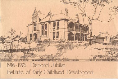
The Free Kindergarten Union of Victoria commenced teacher training in 1909. A two year course was run in cooperation with the Education Department in 1910-14, but from 1917 the Union trained its students independently. In 1922 the Kindergarten Training College was established in Mooroolbeek, Kew. In 1965, the institution, as the Melbourne Kindergarten Teachers' College, became an entity separate from the Union, and in 1973 joined the State College of Victoria as the Institute of Early Childhood Development. It subsequently amalgamated with the University of Melbourne to become the Department of Early Childhood Studies and moved from Madden Grove, Kew, to 234 Queensberry St, Carlton, early in July 1997.[16]p. : ill., ports. ; 19 x 28 cm. Includes photographs of the Institute, its leaders and students. Included are a chronology and a number of photos (above) of Mooroolbeek, part of the complex, which is now all demolished.institute of early childhood development, mooroolbeek -
 Bendigo Historical Society Inc.
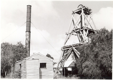
Photograph - WOODEN POPPET HEAD North Hustlers GM, 1969
James Lerk 17/12/2000.North Hustlers Gold Mine. Oregon Poppet head adjoining engine house, galvanized iron buildings, metal chimney peppercorn tree at right. This mine was demolished in 1969.Alan Doneyplace, building, industrial -
 Whitehorse Historical Society Inc.
Photograph - Coloured photograph, Narmara Primary School, 13/01/1994 12:00:00 AM
Coloured photo of Narmara Primary School Site, looking East from South East corner. North side of Highbury Road between Middleborough Road and Blackburn Road. Since demolished and site developed for housing.narmara primary school, warner, philip -
 Whitehorse Historical Society Inc.
Photograph - Coloured photograph, Narmara Primary School, 13/01/1994 12:00:00 AM
Coloured photo of Narmara Primary School, looking South from North West corner. School on North side of Highbury Road between Middleborough Road and Blackburn Road. Since demolished and site developed for housing.narmara primary school, warner, philip -
Whitehorse Historical Society Inc.
Article, History fails to impress, 2004
David Green, owner of a house at 36 Burnett Street, Mitcham wants the Council to remove a heritage overlay so that he can demolish it.David Green, owner of a house at 36 Burnett Street, Mitcham wants the Council to remove a heritage overlay so that he can demolish it. The house was originally owned by John McClare and his son John Edward McClare.David Green, owner of a house at 36 Burnett Street, Mitcham wants the Council to remove a heritage overlay so that he can demolish it.burnett street, mitcham, no 36, green, david hamilton, mcclare, john, mcclare, john e, city of whitehorse -
 Whitehorse Historical Society Inc.
Photograph, House in Queen Street Mitcham
Coloured print from a 110 slide of the detail of a house in Queen Street, Mitcham, (the Raglans) demolished c1974. Photo shows detail of the Australian Tesselated Tile Co. products used.|See also NP1210 AND NP1214 - NP1217queen street, mitcham, raglans, australian tesselated tile co. pty ltd -
 Kew Historical Society Inc
Postcard, National Bank of Australasia, Kew
Monochrome postcard of the National Bank of Australasia on the corner of Walpole and High Streets, Kew. The bank was built in 1888. The two north-eastern bays facing High Street were subsequently demolished in the second half of the 20th century.KH-385national bank of australasia - kew, high street - kew -
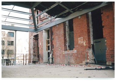 Queen Victoria Women's Centre
Photograph, c.1996
Colour photograph. Ground floor facing south towards Lonsdale street. Entrances show where access corridors were to connect demolished buildings. What was the cafe and in 2015 is the Breacan office. Taken during restoration inspectionhistoric buildings, building construction, cultural structures and establishments -
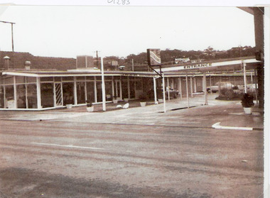 Lakes Entrance Historical Society
Photograph, 1970c
The first 20 units and restaurant were built in 1959 with firsts guests on Dec. 22nd.1959. The units 21-27 plus the front residence and office were built in 1962.Black and white copy photograph of Tween Lakes Motel, showing restaurant opposite new entrance and office which were built after Johns Fish Cafe was demolished. Kalimna escarpment in background. Lakes Entrance Victoriamotels, restaurant, township -
Port Melbourne Historical & Preservation Society
Audio - PMHPS Meeting, Thirst-Aid Kiosk, Ted Rohan, Glen Stuart, 25 May 1998
Recording of PMHPS Meeting on 22.06.1998. Recording done by Glen Stuart at Port Town Hall. Speaker wasTed Rohan from the Thirst-Aid Kiosk, Station Pier (now demolished). Recording duration 1:07:35.piers and wharves - station pier, piers and wharves - waterside workers, transport - shipping, business and traders, edward j (ted) rohan, thirst-aid kiosk -
 Bendigo Historical Society Inc.
Photograph - LA TROBE UNIVERSITY BENDIGO COLLECTION: BENDIGO TEACHERS' COLLEGE GRADUATION
A single page handwritten brief history of the Bendigo Teacher's College hostel for female students, 1945 to the 1950's. Previously known as the Sandhurst Coffee Palace and demolished in early 1980's (see photos 3320.208 and 209)bendigo, education, la trobe university bendigo, la trobe university bendigo collection, collection, bendigo teachers' college, bendigo, education, teaching, teachers, staff, students, bendigo teachers' college graduation, bendigo teachers' college staff, bendigo teachers' college students, teacher training, tertiary education, photo, photograph, photographs, photography -
 Stawell Historical Society Inc
Photograph, Wimmera Flour Mill during Demolition -- Coloured
Various colour photos of Wimmera Flour Mill at time it was being demolished. Note roof being dismantled. Rail line in foreground. Willaim Frayne founded the Wimmera Flour Mill on a site in Taylor Street (beside the railway line) Stawell 1876. When Willian Frayne dies 1899 his son George took over the mill. The mill continued to be a propriety company until early 1966, when it was sold to the Victorian Mill Owners. The sale was forced because of the lack of export markets. A factor which affected most country mills. The Victorian Oat Growers Pool took over on July 1st, 1967. Trading under the name of Wimmera Flower Mill as a subsidiary company. Later years it sold clipped and graded seed, oats, stockfeed for poultry, pigs and dairy cattle and all types of crushed grain. The original Frayne homestead still stands behind where the Mill stood facing Frayne Street. In 2007 during our "Collection Review" the four smaller colour photos, which were donated by Mr. Mick Walsh, 52 Patrick St Stawell were very similar to the bigger photo in the file 139.6e.139-6 a-d & e Coloured photographs showing various views of the Wimmera Flour Mill or Grain Handling Corporation building in progress of being demolished. There is a red brick building with a tiled roof in these coloured photos. The rail line is shown in foreground of 139-6 e. Our records on the data base show 139-6e to be a black & white photo but the same photo in the office folder is an enlarged colour photograph. Grain Handing Corporation stawell industry -
![Airing Court Shed [demolished 1976], Kew Cottages](/media/collectors/550653872162f11fb04854aa/items/57a01944d0cdd121042a07ed/item-media/57a019f6d0cdd121042a4183/item-fit-380x285.jpg) Kew Historical Society Inc
Kew Historical Society IncPhotograph - Airing Court Shed, Kew Cottages
The Children's Cottages at Kew were first opened in 1887 as the "Idiot Ward" of Kew Asylum. Located on the asylum's grounds, the children's cottages were established to provide separate accommodation for child inmates who had previously been housed with adult patients. Although the Cottages only admitted children as patients, many of those children remained in residence at the Cottages as adults. The function of the institution was to provide accommodation and educational instruction for intellectually disabled children. Some Wards of the State and other various "difficult" children were also admitted.Shortly after opening, the Idiot Ward began functioning separately from the Kew Lunatic Asylum, and became known as the Kew Idiot Asylum from 1887 until c.1929. From 1929 they have been known as the "Children's Cottages, Kew" or alternatively "Kew Cottages Training Centre". The institution was finally closed in July 2008. [Source: Wikipedia, 2016]One of a series of framed historical photographs of the Kew Cottages that once formed part of the collection of the Kew Cottages Historical Society, founded by Dr. Cliff Judge and Fran Van Brummelen in the 1980s. The set contains both copies of originals in other collections such as the Public Record Office Victoria and photographs taken by Dr Judge for his books on intellectual disability in Victoria. The significance of the set of framed photographs is that they provide a curated collection of images of the development of the Cottages over a one hundred year period.Framed photograph, forming part of the Kew Cottages collection, donated by Kew Cottages Historical Society 1987-1993 in 1993. Dr. Judge was a consultant psychiatrist at the cottages for 14 years, as well as an author and vocal advocate for the intellectually disabled and their families." Kew Cottages - Airing Court Shed demolished 1976. The building in the foreground was a so-called 'airing-court-shed'. The other building is an old Court Pell hut (ex Royal Park) transported here after World War II. There were two other such huts behind this. All these buildings were demolished in 1976 to make way for the Graham Perkins Unit."kew cottages, dr cliff judge, kew cottages historical society 1987-1993 -
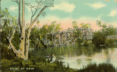 Kew Historical Society Inc
Postcard, Scene at Kew
Colourised owl photo postcard entitled;led 'Scene at Kew'. In the background is the Zig-Zag Bridge.Obverse: "Scene at Kew". Reverse: "Zig Zag Bridge adj[acent] Kew Asylum / now demolished / in this era / now called / Donated by Mrs B Challen"bridges - yarra river -- kew (vic.), zig-zag bridge, postcards -- kew (vic.) -
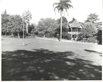 Kew Historical Society Inc
Photograph, Alexandra Gardens, c.1960
Rotunda, Alexandra Gardens (1910-c.1960). The Alexandra Gardens’ rotunda was located within three acres of ‘gem like’ gardens ‘bright with verdant lawns and choice blooms’ in the centre of Kew. Designed by architects Grainger and Little, the ornate two-storey wooden kiosk functioned as a children’s shelter on the ground level and a bandstand and oratory dais on the upper. Funded by council and community subscription, it was a ‘symbol of the public spirit of Victoria’ and a Kew Jubilee commemoration memorial. Opened in 1910, the Kew Brass Band christened it the ‘finest band rotunda in Melbourne’. Deterioration saw its demise 50 years later. This work forms part of the collection assembled by the historian Dorothy Rogers, that was donated to the Kew Historical Society by her son John Rogers in 2015. The manuscripts, photographs, maps, and documents were sourced by her from both family and local collections or produced as references for her print publications. Many were directly used by Rogers in writing ‘Lovely Old Homes of Kew’ (1961) and 'A History of Kew' (1973), or the numerous articles on local history that she produced for suburban newspapers. Most of the photographs in the collection include detailed annotations in her hand. The Rogers Collection provides a comprehensive insight into the working habits of a historian in the 1960s and 1970s. Together it forms the largest privately-donated collection within the archives of the Kew Historical Society.Lawn and original rotunda in the Alexandra Gardens, Cotham Road, Kew. The Alexandra Gardens were opened in 1908. The land on which the gardens were formed originally formed part of the Madford Estate. A feature of the gardens was a large brick, wood and tiled rotunda. "Alexandra Gardens. Formerly part of S. King. (Rest of Estate mainly belongs to St Anthonys home). Opened 1908. Alexandra Gardens. (Rotunda now demolished)"alexandra gardens, kew, dorothy rogers -
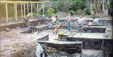 University of Melbourne, Burnley Campus Archives
Photograph - Colour print, Burnley Campus Archives, Students Building the Sunken Garden, 1983
Appears to have been used for an exhibitionColour photograph pasted on black paper which is pasted on polystyrene board. Students constructing the Sunken Garden and Wisteria Walk. Used in an ExhibitionCaption, "The house was demolished in 1980. Geoff Olive, the Gardens Manager designed the new landscaping. Students building the Sunken Garden 1983." Work had commenced 1981.geoff olive, gardens manager, sunken garden, students working outside, principal's residence, garden design, wisteria walk