Showing 15695 items
matching docuents-maps-france
-
 Lara RSL Sub Branch
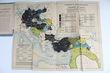
Booklet With Map, Cassell and Compnay Limited, Subject Nationalities of the German Alliance, 1917
Map Produced for Allied ForcesMap of German Alliance as to which nationalities were aligned with GermanyGrey Booklet containing Coloured map of the German AllianceGrey Booklet Subject Nationalities of the German Alliance (With a coloured map from German Sources) Cassell and Company Limited London New York Toronto Melbourne 1917 Price 2d -
 Running Rabbits Military Museum operated by the Upwey Belgrave RSL Sub Branch
Pilot's Map
Part of Survival KitMap mainly of French Indo Chinaequipment, ww2, raaf -
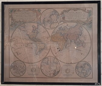 Flagstaff Hill Maritime Museum and Village
Map - World Map, Mappe Monde [Medieval Map of the World], 1910
This map from the mid-18th century doesn't include the finer details of land and sea masses that we know today. The map was produced by German cartographer and publisher, Johann Baptist Homann (1663-1724) and published in 1746, after his death. Earlier versions were published, such as 1707 and 1716. The date can be calculated from the Roman numerals on the top left text area. This print of a map is significant for its connection with early world explorers. A comparison of maps over the centuries shows the progression of navigational technology, the countries who claimed the land they explored. The naming of even some Australian locations shows who had already made their mark on Australia in the early 18th century. The print shows the fine details included by the cartographer and the beauty included that makes it attractive and interesting even today. The map is also significant for its connection with German cartographer, Johann Baptist Homann, whose Homann publishing company was renewed in Germany for producing high quality maps and atlases. Map behind glass in dark brown wooden frame on beige paper. The Coloured hand drawn line drawings show different hemispheres of the known world in the mid-18th century. Beautifully drawn figures and decorative embellishments enhance the map. The text on the top right has an explanation of the Figures I, II, III, and IV. This print of the 1746 map was produced in England by Leisure Arts Ltd. "PLANIGLOBIL TERRESTRIS" "MDCCXXXXVI" [1746] "MAPPE_MONDE" [Medieval Map of the World] "LEISURE ARTS LTD" "Printed in England"flagstaff hill, warrnambool, flagstaff hill maritime museum, flagstaff hill maritime village, flagstaff hill maritime museum and village, shipwreck coast, world map, french map, 18th century map, leisure arts ltd, cartography, early exploration, cartographer, johann homann (1663-1724), exploration, naviagtion, 1746 planiglobil terrestris -
 Bendigo Military Museum
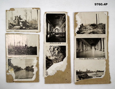
Photograph - PHOTOGRAPHS WW1
Photos from "Frederick James Baxter MC & Bar". Refer Cat No. 4219 for details.Series of small black and white photos stuck to cards relating to WW1 France Battlefield. 1. Picture of 3 ANZAC soldiers in field with 9.2 and 5.9 German shell casing. 2A. Picture of two ANZAC Soldiers in field with 9.2 shell casings and equipment. 2B. Picture of soldier on a road with ruins on either side in France. 3A. Picture of a Hall of Mirrors Versailles. 3B. Picture of unidentified ruins of a building with bomb damage. 4A. Image of bombed out battlefield with 9.2 Suzi Equip destroyed. 4B. Image of Hall of Mirrors Versailles. 4C. Image of bombed out village in France.Words unclear. 1P 9.2 and S9. 2A 9.2 Misc Ballen B. Aillea. 3A Versailles 4A. 9.2 Suzi Ballere 4B. Hall of Mirrors, Versailles.photographs, frederick james baxter, ww1, france -
Clunes Museum
Container - POWDER BOX
SMALL ROUND CARDBOARD BOX WITH BLUE AND GOLD DECORATION AND ON BOTTOM 'MRS CAROLAN' AND 3 MEDALS'PARIS D'ORSAY FRANCE' ON SIDE. 'POUDRE COMPACT DORSAY - COLEUR ROUGE POUR BLONDES'local history, personal effects, cosmetics, toiletries -
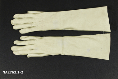 Whitehorse Historical Society Inc.
Clothing - Gloves
Pair of suede mid-length beige or fawn women's size 6 3/4 gloves with 3 stitched darts along back of hands. Gloves are joined near openings with length of white cotton. Labels and printed markings inside both gloves.Inside right hand glove : 'Made in France / 6 3/4 / (in cursive) Suedelav' Inside left hand glove : 'Leather / Made in France' '207' on paper label : 'V4/86L/ipx/39/6'costume accessories, female -
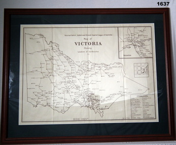 Bendigo Military Museum
Map - MAP, FRAMED, Bethany Gallery, 1949
This map originally came via Mitiamo East Loddon RSL who when they closed their Sub branch the map and their records were handed to the Bendigo RSL for safe keeping. It was framed and was hanging in the Office of the SMI until the renovations to the building in 2016.Dark green mount with brown wooden frame. Brown printing on cream paper. Perspex covering map.Top centre of map: “Returned Sailors, Soldiers & Airmen's Imperial League of Australia Map of Victoria showing Sub Branches 1949” Stamped on rear: Bethany Gallery. Traditionally a touch of Excellence Terry ? Jarvis, 116 Bridge Street, Bendigo Vic 3550 Ph (03) 5442 4771brsl, smirsl, map rsl's -
Clunes Museum
Postcard - POST CARD
CHRISTMAS POST CARD FROM NORMAN THOMAS SEND TO HIS SISTER HANNAH FROM FRANCE IN 1917 DURING W.W.1 WITH FABRIC INSERT HOLDING A CHRISTMAS GREETING.WITH BEST WISHES FROM YOUR LOVING BROTHERXXXXX A MERRY XMAS AND A HAPPY NEW YEAR. WRITE SOON.local history, document, post card, w.w.1 memorablia -
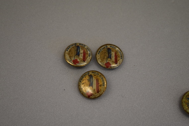 Warrnambool and District Historical Society Inc.
Badges, French Red Cross: France's Day
These badges were issued in World War One to raise funds for the victims of the war in France. Three of the badges are specifically connected to the French Red Cross (Croix Rouge Francaise) established in 1864. These badges were sold nationally in Australia during World War One to assist the people of France.These badges are retained as examples of the efforts in Australia during World War One to assist the people of France..1 Three circular metal slightly concave badges with pin clip on the reverse. The badges feature the Tricoleur and a a red cross with rays around it on a gold coloured background. There is text on a white surround and the rim is gold coloured. .2 One circular slightly concave badge with pin clip on the reverse. The badge features the Tricoleur on a gold coloured background with text. .1 FRENCH RED CROSS .2 FRANCE'S DAYworld war one, tricoleur -
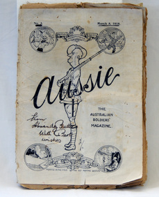 Orbost & District Historical Society
magazine, Aussie, March 18, 1918
Alexander Butters enlisted on 12 November 1914 as a gunner. He was awarded a Meritorious Service medal for his "determination and courage .....setting a splendid example to his men..." on the SOMME. 'Aussie' (1918- circa 1929) was a commercial magazine of opinion, review and entertainment. It was edited by Phillip Harris and published in France 1918 - 1919 on a small printing press that Harris brought with him to France. Initially the print run was only 10,000 copies, but soon it reached 60,000 and later 100,000. The magazine celebrated a distinctive 'Aussie' identity through language, humour and imagery. It distributed news, provided light-hearted ways of seeing the war experience and gave soldiers an outlet to express dissent or dissatisfaction. It also provided a voice for Australian authors such as Banjo Paterson, C.J. Dennis and Bernard O'Dowd. (Ref Museum Victoria)This magazine provides an Australian soldiers' view of the political and world climate during World War I, and also represents the bond between Australian soldiers. The magazine celebrated a distinctive ?Aussie? identity, through language, humour and their assertion of what it meant to be an Australian. It allowed news to be distributed, gave the soldiers an outlet to express any dissent or dissatisfaction, thus preventing any greater form of rebellion and promoted Australian authors like Banjo Paterson, C.J. Dennis and Bernard O'Dowd. (Ref. Museum Victoria)A thin black and white paper magazine called "Aussie". This is Volume 3. The magazine contains stories, illustrations, songs and poetry from the First World War. On the front cover the title is printed across the centre, with a drawing of a soldier in uniform standing sideways, and holding a gun. Four drawings within circles are positioned in each corner, joined by a wreath and ribbons bearing the names of the war fields. His head is in the shape of the map of Australia. On front cover - From Alexandy Butters with best wishesmagazine ww1 aussie military -
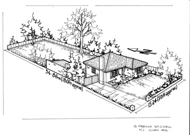 Camberwell Historical Society
Drawing (series) - Architectural drawing, 13 French Street, Camberwell, Unknown
artist, architectural drawings, margaret picken, camberwell, housesartist, architectural drawings, margaret picken, camberwell, houses -
 Whitehorse Historical Society Inc.
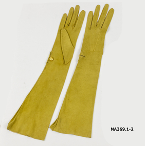
Clothing - Gloves
Pair lemon kid gloves, elbow length. 1 lemon pearl button. 'Made expressly for 'Powells'/60 Old Bond London W./Made in France/9000 3'costume accessories, female -
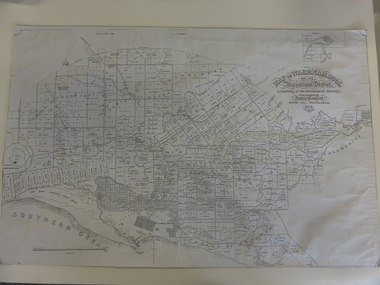
 Wonthaggi & District Historical Society
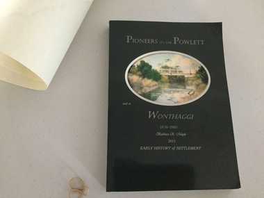
Book and Map, Barbara Moyle, Pioneers on tthe Powlett and at Wonthaggi 1878-1910, 2015
Book - families social histories, maps, photograps Map - block numbers town names physical / geographical featuresFarming and social history of pioneers of the Powlett River are prior to the establishment of the State Coal Mine at Wonthaggi. Significant land marks, buildings and photographs are included. Dark green cover with oval artists impression of Powlett river and bridge Associated map which covers the parishes plus key places of interestlPioneers on the Powlett and at Wonthaggi 1878-1910 Barbara R Moyle 2015 Early History of Settlement Map - Parish names, significant sitesfarming, pioneers of wonthaggi and district, wonthaggi families -
 The Beechworth Burke Museum
Photograph
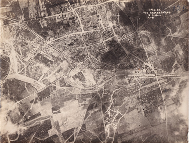
Taken some time between 1914-18, the photograph depicts an aerial view of Villers-Bretonneux in France, a region which was part of the Western Front during World War I. The image mostly shows rural landscape. The Western Front was the main theatre of war during World War I. Following the outbreak of war in August 1914, the German Army opened the Western Front by invading Luxembourg and Belgium, then gaining military control of important industrial regions in France. The German advance was halted with the Battle of the Marne. Following the Race to the Sea, both the French-British and German armies dug in along a meandering line of fortified trenches, stretching from the North Sea to the Swiss frontier with France. The First Battle of Villers-Bretonneux occurred between 30 March - 5 April 1918. It took place during Operation Michael, part of the German Spring Offensive on the Western Front. The offensive began against the British Fifth Army and the Third Army on the Somme, and pushed back the British and French reinforcements on the north side of the Somme. The capture of Villers-Bretonneux, close to Amiens, a strategically important road and rail-junction, would have brought the Germans within artillery-range. In late March, troops from the Australian Imperial Force were brought south from Belgium as reinforcements to help shore up the line. In early April, the Germans launched an attack to capture Villers-Bretonneux. After a determined defence by British and Australian troops, the attackers were close to success until a counter-attack by the 9th Australian Infantry Brigade and British troops late in the afternoon of 4 April restored the situation and halted the German advance on Amiens. The Second Battle of Villers-Bretonneux occurred between 24 - 27 April 1918, during the German Spring Offensive to the east of Amiens. It is notable for being the first occasion on which tanks fought against each other. A counter-attack by two Australian brigades and a British brigade during the night of 24 April partly surrounded Villers-Bretonneux, and on 25 April, the town was recaptured. On 26 April, the role of the Moroccan division of the French army was crucial in pushing back German units. Australian, British and French troops nearly restored the original front line by 27 April.The record is historically significant due to its connection to World War I. This conflict is integral to Australian culture as it was the single greatest loss of life and the greatest repatriation of casualties in the country's history. Australia’s involvement in the First World War began when the Australian government established the Australian Imperial Force (AIF) in August 1914. Immediately, men were recruited to serve the British Empire in the Middle East and on the Western Front. Additionally, the record's significance is enhanced by its depiction of Villers-Bretonneux. The battles that occurred in this town during World War I are especially historically significant to Australia as this is where the Australian Imperial Force had one their greatest World War I victories. An Australian flag still flies over Villers-Bretonneux in the present. Furthermore, a plaque outside the Villers-Bretonneux Town Hall recounts the battles fought to save the town in 1918. Kangaroos feature over the entrance to the Town Hall, and the main street is named Rue de Melbourne. More officially, recognition of the significance of the battle in Villers-Bretonneux is found at the Australian National Memorial, which was built just outside the town. It commemorates all Australians who fought in France and Belgium and includes the names of 10,772 who died in France and have no known grave. Each year, a small ceremony is held at the memorial to mark the sacrifice made by the soldiers. Lastly, the record has strong research potential. This is due to the ongoing public and scholarly interest in war, history, and especially the ANZAC legend, which is commemorated annually on 25 April, known as ANZAC Day.Sepia rectangular photograph printed on matte photographic paper.Obverse: yAE.2.35. / 125 / 62d.2834.35.36.VA.5. / 12.G.18-11 / F.-(?)" /military album, wwi, world war i, villers-bretonneux, australian imperial force, aif, france, war, army, conflict, germany, 1918, battle -
Bendigo Historical Society Inc.
Map - PART PARISHES OF MANDURANG AND SANDHURST, No date visible
Map: Section of Parish plan of Bendigo covering Mandurang, Diamond Hill, and Quarry Hill, ( number 147 in Map Cupboard 1).Map 11map, bendigo, city streets, parish of mandurang, parish of sandhurst, diamond hill , quarry hill -
 Bendigo Military Museum
Souvenir - TRENCH ART
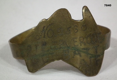
Part of the Cooper Collection. "John Percy VERCOE", No. 2530, enlisted 18/5/16 in 5th Reinforcements, 60 BN. Aged 30 years. Embarked for England 25/9/1916, embarked for France 4/2/1917, WIA 26/4/1918. GSW to left eye, severe. Left eye excised England 30/4/1918. RTA 23/9/1918. Discharged from the AIF 4/1/1919. Passed away 30/12/1925. John received a Congratulatory card from MAJ.General J.H. Hobbs, K.C.B, V.D. Commanding 5th Aust. Division - for bravery and devotion to duty in dressing and carrying wounded to the Regt. Aid Post during a counter attack on Villers Brettoneux on the night of 24/25th April 1918.Brass map of Australia fashioned into a bracelet. Band is secured with a clip. Owners details engraved on the map.Engraved in the face of the map: 'No.2530, PTE J.P. VERCOE, 60TH BATT, AIF, 1916.cooper collection, trench art, john p. vercoe -
 Montmorency/Eltham RSL Sub Branch
Map - Framed Japanese Map of Darwin Circa 1942, WW2 Japanese Map of Darwin, Estimated date 1940-41
... maps ...Returned to Australia, from America, where it had been brought back from Japan.Framed map of Darwin with Japanese overprint.'This map is a proof copy of a Japanese Reprint of an Australian map of Darwin.'darwin, world war two, japan, australia, 1942, 1941, maps -
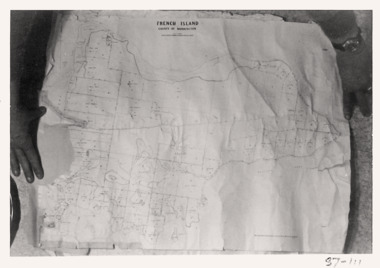 Queenscliffe Maritime Museum
Map - French Island, County of Mornington, French Island map photographs x 2, c1987
Islands off Victorian coastFrench Island mapFrench Island map photographs x 2Reverse " Nil "french island -
Bendigo Historical Society Inc.
Map - PART PARISHES OF MARONG AND LOCKWOOD, No date visible
Map: Section of Parish plan of Bendigo, covering Kangaroo Flat, Golden Square, and Specimen Hill ( number 146 in Map Cupboard 1)Map 10map, bendigo, city streets, parish of marong, parish of lockwood, kangaroo flat, golden square, specimen hill -
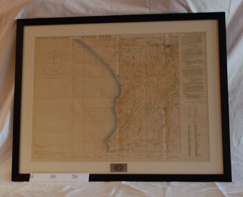
 Bendigo Military Museum
Map - MAP FRANCE, FRAMED, Ordinance Survey 1918, c.1918
Thin wooden frame with green border, glass front. Amiens,France. War Office October 1915.Amiens France 1:100,000 For Office Use Onlydocuments-maps, france, frame accessories, amiens -
 Warrnambool and District Historical Society Inc.
Map, Warrnambool 1859, Late 20th century (copy)
This is a copy of Bromfield’s 1856 map of Warrnambool and district. James Astley Bromfield was a pioneer settler in Warrnambool. He established a chemist’s shop in 1854, initially situated in Timor Street. He moved his shop to Liebig Street with a new building erected in 1875. Bromfield was a prominent resident of Warrnambool (Shire Councillor, Fire Brigade member, Cricket Club member, associated with horse racing etc). He was interested in preserving the history of Warrnambool and this map he produced in 1856 was an example of this interest.This is a copy only but this 1856 map is of prime importance as it contains the names of the original landowners of land in north Warrnambool and the surrounding district. It is a frequently-used resource by historians.This is a copy of a map of Warrnambool and its agricultural district published by James Astley Bromfield in 1856. The map is mounted on cardboard and has black printing on a white background. ‘Map of Warrnambool and its Agricultural District according to the Government Survey’s published by Astley Bromfield, Medical Hall, Warrnambool 1856, James Ferguson, Lithr., Melbne.’bromfield’s 1856, map, warrnambool and district -
 Warrnambool and District Historical Society Inc.
Document, Map: Lady Bay 1853, 1853
This is one of the earliest surveys and maps of Warrnambool harbor, Lady Bay. Being done in 1853, it shows the depths of the bay area marked in fathoms, currents and directions and areas of rocks around mouth of the Merri and the Western side of the bay as well as a large sand spit to the middle right of the beach region.. It also marks the large areas of seaweed and fuci in the outer bay area. It has the area of Pertobe Lagoon marked and shows the early tracks to the town. The engraving work was done by Tulloch and Brown, with Tulloch being one of the earliest engravers and lithographers in the state of Victoria. He arrived in Melbourne in 1849 and set up business with James Davie Brown in 1853 with Brown being a map engraver. They were awarded bronze and silver medals for their work at the Victorian Industrial Exhibition. He also worked in the vignettes on the Proeschel Map of Victoria.This map is of high historical and comparitive significance as it shows the Lady Bay area prior to the changes that have occurred in the last 160 years with the building of the breakwater. The issue regarding access to Lady Bay remains a current one. The engraver D Tulloch engraved some of the earliest scenes of the goldfields in Ballarat and as such has left a record of a very early and important era in Australian history. Rectangular cream paper with black text. Map area is outlined by fine black lined border. Key in top right hand corner and scale at bottom middle of map.Map is labelled Town of Warrnambool printed at top of map. Small logo at top right corner which has “Hydrographic Department” in circle around an anchor. Lady Bay Warrnambool Surveyed by John Barrow assistant surveyor Engraved by Tulloch & Brown in bottom right corner. Melbourne engraved by order of the legislative Council of Victoria in middle bottom.map, warrnambool, town of warrnambool map 1853, tulloch & brown map 1853, lady bay warrnambool,, warrnambool harbour, warrnambool breakwater, warrnambool beach -
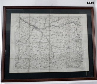
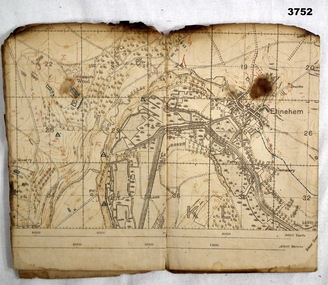 Bendigo Military Museum
Map - TRENCH MAP WW1, 1918
Areas covered on this map, “Ribemont, Morlancourt, Dernacourt, Fricourt, Mericourt, Saily Le Sec” Item re William Alexander No 502 AIF. Refer Cat No 3746.3 for his service details.Trench map, France, Edition 2 E, sheet 62D N.E, scale 1:20,000, trenches corrected to 28.5.1918, German trenches in red, British in blue.map, france, trench -
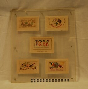 Montmorency/Eltham RSL Sub Branch
Postcard - Hand Embroidered Postcards, WW1 Hand Embroidered Postcards, 1917
A display of five hand embroidered World War One postcards mounted on a board and protected by glass. Multi-coloured lettering on a white background. From One in Camp, Harrah for England, 1917 Souvenir de France - I'm Thinking of You Until the End.embroidery, 1917, postcards, souvenirs, first world war -
 Eltham District Historical Society Inc
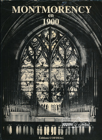
Book, Editions COFIMAG, Montmorency en 1900; Collection <<Nos villes en 1900>> II / edited by J.P. Neu and A. Magarian, 1984
This book is in the French language and predominantly includes sepia reproductions of postcard views of Montmorency, France in the nineteenth century. This book is significant in the understanding of the place of Montmorency in France in context with the local place of Montmorency, Victoria which in turn was named for Montmorency, Val-d'Oise in France.Hardback with dust jacketmontmorency (france) -
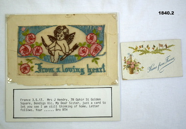 Bendigo Military Museum
Card - SILK CARDS, C.WW1
“Your Bro RTH” relates to Robert Thomas Heard No 5105, KIA. Refer Cat no 1893.2P for his service history..1) Card sent to Mrs J Hendry from France. .2) Card sent to Mrs J Hendry from France..1)” Kisses from France” .2) “From a loving Heart “ “France 3.5.17 Mrs J Hendry 78 Ophir St Golden Square Bendigo Vic” “My dear sister Just a card to let you see I am still thinking of home letter follows Your bro RTH”documents cards, silk -
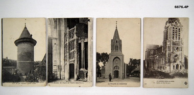 Bendigo Military Museum
Postcard - POSTCARDS WW1, PHOTOGRAPHIC, Possibly pre WW1
Series of photos of towns and churches in northern France that were relevant to various battles in WW1.1. B & W photo of tower circa 1431 in Rouen France. 2. B & W picture of Church gate at Eglise Saint-Maclou in Rouen France. 3. B & W photo of French chapel - :La Chapelle De Caestre in Northern France. 4. B & W photo of Church in Neve - Berquin, a town in Northern France.1. Titled - "Rouen - Tour De Fut Enfernee Jeanne D'Arc". 2. Titled - "Rouen - Escalier Des Orgues De L'eglise Saint - Maclou". 3. Titled - "La Chapelle De Caestre". 4. Titled - "La Guerre Dans Le Nord"passchendaele barracks trust, postcards, ww1, france -
 Bendigo Military Museum
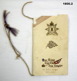
Card - XMAS CARD WW1, 1915-1918
Stanley Arthur BARRIE No 3176 enlisted in the AIF in Section A 6th Field Ambulance on 7.1.1915 age 23 years 8 months. Embarked for Egypt 4.6.1915, embark for Gallipoli 30.8.1915, hospital 8.10.1915 (unclear) rejoin unit 20.10.1915, embark for France 19.3.1916, hospital 12.11.1916 with Blistered Feet, rejoin unit 5.12.1916, detached to 2nd Div Engineers 6.7.1917, rejoin unit 29.12.1917. After getting himself into trouble AWOL twice then threatening an Officer he transfers to the 23rd Batt on 20.8.1918, KIA 1.9.1918.Xmas /New year card from Pte S BARRIE. The outer cover is yellowish cardboard with a light paper on the inside. A string tassel runs up through the spine with a faded purple tassel on the end.Front cover; Australian Engineers badge with a spring of wattle under then the words “One King, One Flag, One Empire” with a crown and flag. Under the words “On Active Service 1915-1918”. Inside has; “Best wishes for a Merry Christmas and a Happy New Year from Private S.A.Barrie A.A.M.C, 5th Field Coy Australian Engineers France” A.A.M.C meaning Australian Army Medical Corp.documents - cards, military history - souvenirs, xmas, engineers -
 Bacchus Marsh & District Historical Society
Map, Plan of Survey of Part of Crown Allotment 9, Parish of Korkuperrimul, 1890
This map documents a transfer of an allotment of land in Clarke Street Bacchus Marsh in 1890. Clarke Street is located on the eastern side of Bacchus Marsh not far from Main Street and Crook Street. It is now known as Candeloro Street. The map indicates J. Booth as the owner of the land and H. Simpson as the occupier. Next to this allotment is a an allotment of land owned by J. Elmore,Single page map showing Crown allotment 9, Parish of Korkuperrimul, County of Bourke. Scale 100 feet to inch. Part of a set of maps which are pasted into a bound volume containing 76 maps or plans in total. High resolution digital image stored on BMDHS computer network. At bottom of map: I hereby certify that I have made this survey expressly for the purpose of an application under the Transfer of Land Statute that this plan is correct. Barry B???, Lic. Surveyor, 16.10.90bacchus marsh victoria maps, clarke street bacchus marsh maps -
 Whitehorse Historical Society Inc.
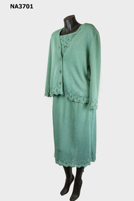
Clothing - Womens Knitted Suit, 1982
Bought to wear to donor's son's wedding and then didn't use the garment for the occasion. Wore it only two or three times since.1982 Three piece Jade ensemble in acetate and polyamide fabric. Summer weight French Spangaro label. Top has scalloped edging on neck and cap sleeves. Long sleeved jacket has clear buttons.costume, female