Showing 1562 items
matching documents - maps
-
 Flagstaff Hill Maritime Museum and Village
Document
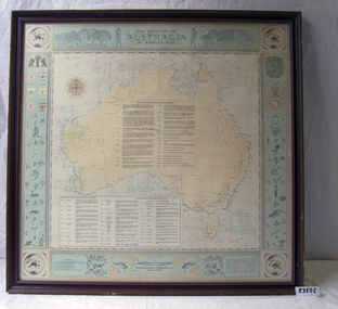
1) Large map of Australia with information on explorers, navigators etc involved in its discovery. Title "The Discovery of Australia by Western Man" 2) Poster which explains in full information formulated on .1 Also gives in great detail natural history information relevant to the formation of the Australian continent.flagstaff hill, warrnambool, shipwrecked-coast, flagstaff-hill, flagstaff-hill-maritime-museum, maritime-museum, shipwreck-coast, flagstaff-hill-maritime-village -
 Federation University Historical Collection
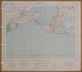
Map, Queenscliff, 1942, 1942
... "This map in an official document, if found, it must... corio bay port phillip bay "This map in an official document ...Two copies of printed colour map on paper showing Queenscliff and surrounds"This map in an official document, if found, it must be handed in to the nearest military headquarters or police station."queenscliff, portsea, point nepean, point lonsdale, barwon heads, geelong, corio bay, port phillip bay -
 Federation University Historical Collection
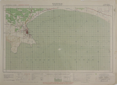
Map, Portland, 1942, 1942
... "This map is an official document. If found, it must... cape nelson lawrence rock point danger whaler's point "This map ...Printed colour map on paper"This map is an official document. If found, it must be handed in to the nearest military headquarters or police. porland, cape nelson, lawrence rock, point danger, whaler's point -
 Federation University Historical Collection
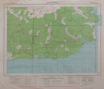
Map, Mallacoota, 1942, 1942
... This map is an official document, if found, it must... bay This map is an official document, if found, it must ...Printed colour map on paperThis map is an official document, if found, it must be handed in to the nearest military headquarters or police stationmallacoota, bass straight, cape evarard, cann river, genoa river, disaster bay -
 Federation University Historical Collection
Photograph - Photograph and Documents, Anne Beggs Sunter, Latta/Downing Family, Mount Helen
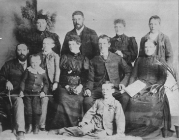
The Federation University Mt Helen Campus was once the farm of John Latta and his wife Elizabeth Ann Dean. The couple married in 1867 and had three children at the time of John Latta's death (Elizabeth Ann b.1870; Mary b.1873; John b.1875). Elizabeth later married George Downing, and had another six children. The house was situated in the vicinity of the current Administration and Caro Conference Centre buildings, surrounded by an orchard, and a well under the current Albert Coates Building (Union Building). The land was purchased by the Ballarat School of Mines for their tertiary division from the Stapleton family.Various items relating to the Federation University Mount Helen Campus, and the early settlers on the land, the Latta Family. .1) Parish Plan, including E. Latta, M. Fiscalini, R. Wynne, R. Nixon, J.U. Smith, J. Davis .2) Part of a 1930s ordinance map showing Ballarat, Buninyong and Greenhill .3) Contour Map with the first two Mt Helen Campus buildings included. .4) Drawing a a proposed campus plan .5) Latta Family negativemount helen campus, latta family, greenhill, e. latta, m. fiscalini, r. wynne, r. nixon, j.u. smith, j. davis, parish plan, john latta, elizabeth latta, george downing, elezabeth downing, green hill, pontresina, abraham baxter, g. dean, market gardens, jim downing, bob thornton, j. hateley, martin fanning, toll keeper, anne beggs sunter -
 Federation University Historical Collection
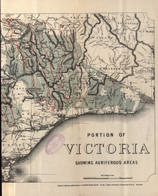
Map - Map and Information, Department of Mines: Map and Suggestions to Prospectors, 1891
... Document: 4 page type written Map: Portion of Victoria divided ...The map outlines the auriferous (gold bearing) areas in Victoria. The information for prospectors was prepared by the Department of Mines in 1894Document: 4 page type written Map: Portion of Victoria divided into Counties of 1891. Auriferous areas with red.Reference section on mapgold, auriferous areas, department of mines, victoria, map of victoria, prospectors, commissioner of crown lands, hon a mclean, alexander black, surveyor general, a mclean -
 Glenelg Shire Council Cultural Collection
Administrative record - Progress Report of Portland Harbour - Royal Commission of Victoria, 1925
Retrieved from the files of the former Maritime Discovery Centre Manager at the Portland Information Centre (A copy of this report is listed in the manifest from the Port of Portland when collection was offered in 1995)Front: Capt. J W Brown -inkport of portland -
 Ringwood and District Historical Society
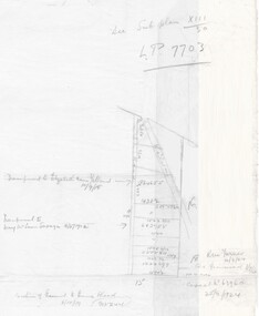
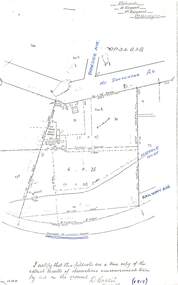
Document - Handwritten extract, Certificate of Title - LP7703 Mary Ann Williams, Bedford Road Ringwood, County of Mornington dated 18/4/1912
Two pages of notes and subdivision sketches on tracing paper.Mary Ann Williams of Bedford Road Ringwood in the County of Mornington, wife of John Williams of the same place, Gardener, is now the proprietor of and estate in fee simple subject to the encumbrances notified herunder in all that piece of land deliniated and coloured red on the map in the margin, containing 72 acres 3 roods and 30 perches of thereabouts being parts of Crown Portion 16, Parish of Ringwood, County of Mornington, together with a right of carriage way over the road coloured brown on the said map. 18/4/1912. Encumbrances - special railway conditions contained in Crown Grant to Nelson Polak. Transfer to Elizabeth Anne Yelland 10/9/1918 Transfer to Mary M Savage 16/5/1912 (?) Easement - Emma Blood 8/10/1919 (?) Turner - 12/3/1924 18 Greenwood Avenue 3/7/1915 Caveat no.63960 25/8/1924 -
 Ringwood and District Historical Society
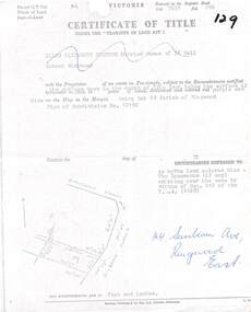
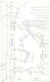
Document, Partial copy of Certificate of Title Vol 7635 Fol 096 Lot 29, 44 Sunbeam Avenue Ringwood East, Victoria
Black and white photocopied page with added notations in blue pen.Ellen Elizabeth Stanton, Married Woman of 35 Bell Street Richmond is now the Proprietor of an estate in Fee-simple, subject to the Encumbrances notified herunder in the surface down to the depth of fifty feet below the surface of the pie of land delineated and colored red purple and blue on the map in the margin, being Lot 29 Parish of Ringwood. Plan of Subdivision No. 12150. (undated). -
 Ringwood and District Historical Society
Document - Copy of Lands Department Field Notes - Ringwood, Victoria, Field Notes 76631 Surveyed in 1878
Foolscap size photocopy of survey map with handwritten notations. References include Canterbury Road, Bungalook Road, Dandenong Creek, Frank Miller, H.K. Kemps, Leech. Notations signed and dated January 1878 and May 1879. -
 Ringwood and District Historical Society
Document - Copy of Lands Department Field Notes - Ringwood, Victoria, Field Notes 86.87/108 - Survey O.P. R72A dated August 1886 by Surveyor, L. Thorn
Foolscap size photocopies of survey maps with handwritten notations. -
 Ringwood and District Historical Society
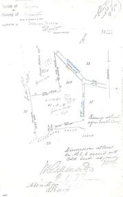
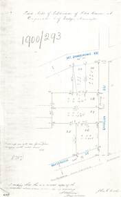
Document - Copy of Lands Department Field Notes - Subdivision of Police Reserve at Ringwood, County of Mornington, Field Notes 1900/293 - Part of O.P. R72C surveyed 1900
Foolscap size photocopy of survey map with handwritten notations. References include Mount Dandenong Road, Dublin Road, Patterson Street, Melbourne to Lilydale railway line, I certify that this is a correct copy of recorded observations made by my assistant (signed) W. Thorn, Staff Surveyor. -
 Ringwood and District Historical Society
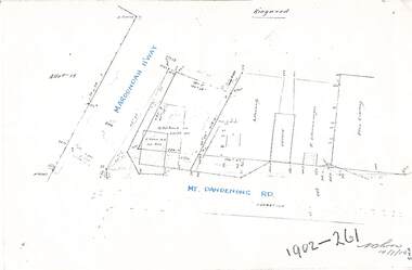
Document - Copy of Lands Department Field Notes - Ringwood, Victoria, Field Notes 1902/261 - Part of O.P. R72D surveyed 14.7.1902
Foolscap size photocopies of survey maps with handwritten notations. -
 Ringwood and District Historical Society
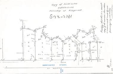
Document - Copy of Lands Department Field Notes - Subdivision Township of Ringwood, Victoria, Field Notes 1902/269 - Part of O.P. R72D surveyed in 1902
Foolscap size photocopy of survey map with handwritten notations. References include Maroondah Highway, (opposite) Mines Road, Ti tree, Sandy soil, heath, spear grass, box & stringy bark sapplings, gentle slope to creek, E. Drury. I certify that this is a correct copy of the recorded observations and measurements made by me personally and my assistant (signed) W. Thorn. -
 Ringwood and District Historical Society
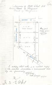
Document - Copy of Lands Department Field Notes - Subdivision of State School Site, Township of Ringwood, Victoria, Field Notes 1903/83 - Part of O.P. R72C Surveyed 13/2/1903
Foolscap size photocopy of survey map with handwritten notations. References include Everard Street, Old Lilydale Road (Maroondah Highway), Dublin Road, poor soil, coarse grass, saplings, I certify that this is a correct copy of the recorded observations & measurements made by me personally (signed) R.J. Gray Autorised Surveyor 13/2/03. -
 Ringwood and District Historical Society
Document - Copy of Lands Department Field Notes - Subdivision of Ringwood, Victoria, Field Notes 1904/188 - Part of O.P. R72D Surveyed 28.4.1904
Foolscap size photocopy of survey map with handwritten notations. References include Mount Dandenong Road to Lilydale, M. Dickson (sold), Church of England, P. Schonnenberger, Helen Lindsay, W.B. iron roof & shingles, I certify that this is a correct copy of the recorded observations and measurement made by me and my assistant (signed) W. Thorn 12/5/04 -
 Ringwood and District Historical Society
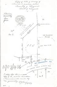
Document - Copy of Lands Department Field Notes - Survey of Extension to Recreation Reserve, Township of Ringwood, Victoria, Field Notes 1907/436 - Part of O.P. R72D Surveyed 6.8.1907
Foolscap size photocopy of survey map with handwritten notations. References include New Lilydale Road 3 chains wide (Mount Dandenong Road), Silurian, undulating, poor grass, Corner cut off to allow for road in future subdivision, Old recreation reserve, (circled area) oval now in use, A. Gisler, I certify that this is a correct copy of the recorded observations & measurements made by me personally (signed) R.J. Gray 6/8/07. -
 Ringwood and District Historical Society
Document - Copy of Lands Department Field Notes - Subdivision Sec E, Township of Ringwood, Victoria, Field Notes 1908/670 - Survey O.P. R72E dated November 1908
Foolscap size photocopies of survey maps with handwritten notations. -
 Ringwood and District Historical Society
Document - Copy of Lands Department Field Notes - Parish of Ringwood, Victoria, Field Notes 1909/174 - Part of O.P. R72D surveyed 12.3.1909
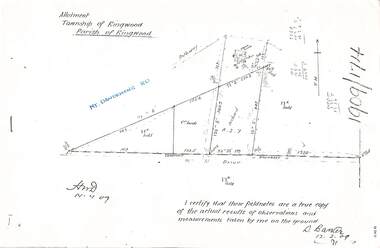
Foolscap size photocopy of survey map with handwritten notations. References include Mount Dandenong Road, pathway, 2 room house, scillion, shed, WC, 17C sold, Cr lands, orchard, 17E sold, Township boundary, I certify that these field notes are a true copy of the actual results of observations and measurements taken by me on the ground (signed) D. Barker 12.3.09. -
 Ringwood and District Historical Society
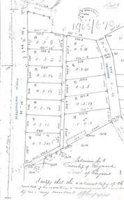
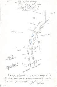
Document - Copy of Lands Department Field Notes - Township of Ringwood, Victoria, Field Notes 1913/163 - Part of O.P. R72D surveyed April 1913
5612b Foolscap size photocopy of survey map with handwritten notations. References include Mines Road, New Lilydale Road (Maroondah Highway), (area) Held for mining, Recreation Reserve, Sec D, Sec E, I certify that this is a correct copy of the recorded observations & measurements made by me personally (signed) R.J. Gray 2/4/13. -
 Ringwood and District Historical Society
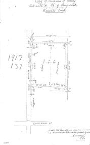
Document - Copy of Lands Department Field Notes - Parish of Ringwood, Victoria, Field Notes 1917/137 - Part of O.P. R72 - Allotment 10, surveyed June 1917
5613b Foolscap size photocopy of survey map with handwritten notations. References include Knight's land, Wantirna Road, Canterbury Road, house, wirenetted, orchard, grass paddock, I certify that these notes are a true copy of observations and measurements taken on the ground by me (signed) H.W. Moore 5/6/17. -
 Ringwood and District Historical Society
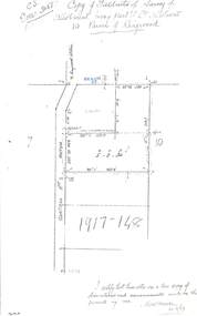
Document - Copy of Lands Department Field Notes - Parish of Ringwood, Victoria, Field Notes 1917/148 - Part of O.P. R72 - Crown Allotment 10, surveyed June 1917
5614b Foolscap size photocopy of survey map with handwritten notations. References include Wantirna Road, to Ringwood Station, Reilly Street, J. Marshall, fence to be erected on boundary, I certify that these notes are a true copy of observations and measurements made on the ground by me (signed) H.W. Moore 22/6/17. -
 Ringwood and District Historical Society
Document - Copy of Lands Department Field Notes - Parish of Ringwood, Victoria, Field Notes - OP34838 - surveyed in 1919 by D. Barker
5615b Foolscap size photocopy of survey map with handwritten notations. References include Braeside Avenue, Mount Dandenong Road, Rosedale Court, Railway Avenue, cyclone fence, Sec A, WB house, old tennis court netted, stable, old shed, tank stand, orchard, Township Boundary, netting fence, Railway fence, Ringwood to Lilydale Railway, I certify that these fieldnotes are a true copy of the actual results of observations & measurements taken by me on the ground (signed) D. Barker (1919). -
 Ringwood and District Historical Society
Document - Copy of Lands Department Field Notes - Parish of Ringwood, Victoria, Field Notes - 1928/453 - Part of OP R72C Surveyed on 17.11.1928
5616b Foolscap size photocopy of survey map with handwritten notations. References include Whitehorse Road, Mines Road, Wilson Street, Rupert Street, New Road (Braeside Avenue), Section E, Allot 31 sold, Allot 32 sold, Recreation Reserve, Allot 25 sold, Allot 29 sold, hedge, spikes, links on line from each corner, I hereby certify that these field notes were prepared from actual observations and measurements made by me or under my supervision on the ground and in accord with regulations (signed) Authorised Surveyor 17/11/28. -
 Ringwood and District Historical Society
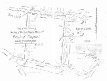
Document - Copy of Lands Department Field Notes - Parish of Ringwood, Victoria, Field Notes - Part of Crown Allotment 17D Surveyed 1952 (Amended in 1953)
5616b Double foolscap size photocopy of survey map with handwritten notations. References include Corr no. C.93151, Railway Reserve, Station Street, Bedford Road, multiple post & wire fences, multiple galv iron pipes put in, Government Road (Hill Street), Tooronga Road, multiple recent pegs found, Certification 52710 by J. Fitzgerald Licensed Surveyor 17/3/1952. -
 Ringwood and District Historical Society
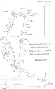
Document - Copy of Lands Department Field Notes - Parish of Ringwood, Victoria, Field Notes 55114 Survey of Allotment by J.D. Sherwood in 1955
5618b Foolscap size photocopy of survey map with handwritten notations. References include Railway (Reserve), Education Department, A-B Datum 117degrees20', Bedford Road, Certification by J.D. Sherwood Licensed Surveyor 23/11/1955. -
 Ringwood and District Historical Society
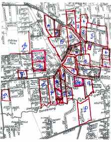
Document, Collection of copies of Maps relating to Wieland Houses and Properties (most undated), plus Document entitle Brian Pump's Orchard and House Locations, 25/2/2008
Collection of A4 photocopies of maps and plans, some with yellow highlighting, showing locations of Wieland properties and house including sub-divisions. Mostly in Heathmont but also Scoresby Most pages are undated and do not have original sources Document 28054 entitled Brian Pump's Orchard and House Locations has notes with maps of various houses with numbers corresponding to those on the included maps and also to those in 28054-003 document -
 Running Rabbits Military Museum operated by the Upwey Belgrave RSL Sub Branch
Map
Area around Ypresdocuments, ww1, general -
 Bendigo Historical Society Inc.
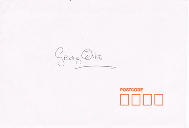
Document - LONG GULLY HISTORY GROUP COLLECTION: ENVELOPE
White Camerons Peel&Seal envelope with orange postcode squares and pale blue printed lining. Made in Australia. It has a map of Australia between the in and Australia. It contained the four photos and has George Ellis written on the front.bendigo, history, long gully history group, the long gully history group - envelope, georg ellis -
 Bendigo Historical Society Inc.
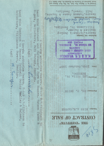
Document - H.A. & S.R. WILKINSON COLLECTION: CONTRACT OF SALE
Contract of sale dated 19th October, 1957 between Miss A.M. Sanger (seller) and Mr. C. Smith (buyer). Solicitor for vendor: Messrs. Tatchell, Dunlop, Smalley & Balmer, Williamson Street, Bendigo. Solicitor for purchaser: Messrs. Watson, James & Rogers, Bull Street, Bendigo. For property No.121 Wills Street, Bendigo being part of Crown allotments 2 and 3 section 116C together with a right of carriage way over the road colored brown on the map on the title, being land described in certificate of title volume 8149 folio 666. Price 1,500 poundsorganization, business, h.a. & s.r wilkinson real estate